
How to help prospective students learn about Edinburgh and campus locations
In preparation for the retirement of the Virtual Visit platform in October 2025, the team ran a project to understand how prospective students orientate themselves with Edinburgh and the campus. I share key findings and how updating programme profiles with Google Maps content can help with orientation.
Context
We know that the University wants to help prospective students get a feel for Edinburgh before they arrive and that students want to get a sense of place to help them decide whether to apply. We needed to learn more about this need and understand what opportunities there were to fill the gap left by the retirement of the Virtual Visit platform.
Goals of the project
The project set out to:
- understand how the University is trying to meet the orientation needs of prospective students
- understand what orientation needs prospective students have and how are they meeting them
- identify what free alternative platforms are available to meet these needs and assess their risks and benefits
- make recommendations for school web publishers on how to support prospective student orientation
Understanding business needs
What we did
We worked with colleagues across different areas of the University involved in recruitment to learn how they were meeting the orientations needs of prospective students.
We worked with:
- Student Recruitment and Admissions (SRA) who are involved with recruitment and responsible for the maintenance of the Virtual Visit platform
- Web publishers from 3 different schools involved in recruitment and updating degree programme profiles
- College of Arts, Humanities and Social Sciences (AHSS) responsible for running recruitment events such as virtual tours
What we learned
Colleagues are meeting prospective student orientation needs in different ways, such as with:
- the Virtual Visit platform map
- Google Maps
- links to virtual tours hosted on school websites
The map feature of the Virtual Visit platform, which is frequently used in recruitment events, struggles to meet this need because it is a graphic illustration and not to scale. This makes it difficult for prospective students to get a sense of perspective and proximity of different city and campus locations as well as travel and transport information.
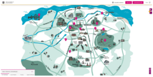
Graphic illustration map that the Virtual Visit platform uses to support prospective student orientation
Colleagues often relied on Google Maps to answer questions relating to travel and transport information that they couldn’t answer using the Virtual Visit platform.
There has been a mixed level of engagement with the Virtual Visit platform with some schools not having updated content about themselves since 2021 when it was first introduced.
Understanding user needs
What we did
We reviewed prior research conducted at an undergraduate Open Day in 2023 to explore awareness and usability of the Virtual Visit platform and reviewed website analytics to understand usage of it.
We then conducted two further rounds of user research:
Round 1: 12 new undergraduate and postgraduate students arriving on campus to complete international check-in 2025 to explore how they look for information that helps them orientate with a new city.
Round 2: 12 new undergraduate and postgraduate students at Welcome Week 2025 to explore how they orientate specifically with Edinburgh and the University campus. We also explored how well a newly designed prototype programme profile with Google Maps content added met the orientation needs of students.
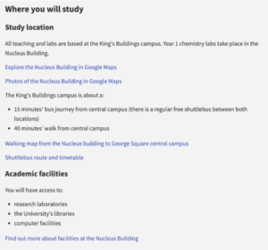
Prototyped programme profile designed in collaboration with the School of Chemistry with Google Maps content to improve student orientation with Edinburgh and campus
What we learned
From usability testing at undergraduate Open Day 2023, we learned:
- most students had not seen the Virtual Visit platform before
- most students found it difficult to navigate
From website analytics that looked at how many visitors to the University website clicked on a link to the Virtual Visit platform, we learned:
- 0.03% of visitors to the university study site during the 2022-2023 academic year clicked on a link to visit the platform
From research with students at international check-in 2025, we learned that most students were using Google Maps to meet orientation needs, which included:
- Travel and transport information relating to locations across the city and campus
- Proximity of amenities such as food and medical facilities to different locations
- Street View to explore and familiarise themselves with locations
From research with students at Welcome Week 2025, we learned that all students were using Google Maps to help meet orientation needs.
By exploring how students are using Google Maps more deeply in this round of research, we learned that the location of teaching is important because students are using this to orientate themselves with the city and campus. Most students told us that they struggled to understand what and where central campus is.
The prototype programme profile tested well with students. They told us that it helped meet their orientation needs by providing access to the kind of content they were already looking for, specifically the walking map which helped them quickly get a sense of where central campus was in relation to their teaching location.
Recommendations
Since the majority students are already using Google Maps to meet their orientation needs and given how well they responded to the prototype programme profile, we have made some recommendations for school web publishers for how to update their own profiles with this information.
Provide a walking map
A walking map helps prospective students get a contextual understanding of the city and campus by learning where they will be taught and its proximity to central campus.
Link to Street View
Street View helps students familiarise themselves with areas where they will spend most of their time.
Upload multimedia content to Google Maps
Uploading multimedia content to the platform helps them further by providing photos or videos of their teaching locations.
We would advise that before you do this, you take ownership of your Google Maps location (see guidance in next section). This provides you with more control over what content you display to prospective students.
Guidance on improving where you will study content
Check our guidance and start improving how you meet your prospective student’s’ orientation needs.
Guidance on ‘where you will study’ content – (University of Edinburgh staff login required)
Not all orientation needs will be met with the same Google Maps content. If you’re not sure what information is most useful to your students, then ask them after they’ve been on campus for a few months.
Learn more
This has been a summary of findings and recommendations from our project to help school web publishers get started.
If you want more detail about the project you can find it on the slides for the presentation that was given to the University community on 22nd October 2025.
View the presentation slides – (University of Edinburgh staff login required)


Great post! The approach of embedding interactive maps and Street-View really helps prospective students get a feel for University of Edinburgh and the city before even arriving.