Any views expressed within media held on this service are those of the contributors, should not be taken as approved or endorsed by the University, and do not necessarily reflect the views of the University in respect of any particular issue.
Digimap is an online map and data delivery service, available by subscription to UK Higher and Further Education establishments. Operated by EDINA at the University of Edinburgh, Digimap offers a number of data collections, including Ordnance Survey, historical, geological, aerial photography, LiDAR, marine maps, land cover mapping, global mapping and census data. For more information about Digimap go to our website: https://digimap.edina.ac.uk Background image Contains OS data (c) Crown Copyright and database right 2022
Join us for an engaging webinar exploring the Geology Collection in Digimap, featuring BGS data products. Helen Burke, 3D Geological Modeller and Surveyor, and Henry Holbrook, Data Sharing Manager at BGS, will guide you through the datasets and how they can support your research and teaching.
May was one of the busiest in terms of dataset updates in the history of Digimap. Around 20 separate datasets have been updated bringing them bang up to date with the most recent data available from the data suppliers. All the updates are listed in the tables below, broken down by the Collection and service that they can be found in.
Withdrawn Datasets (OS Collection):
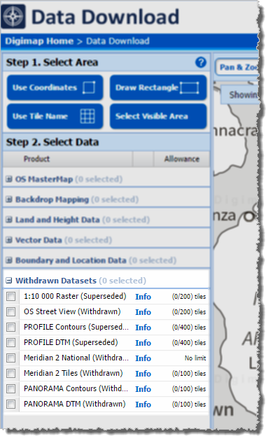
OS Download Withdrawn Datasets [click to expand]Along with the updated data, Ordnance Survey have recently withdrawn three datasets:
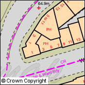
These withdrawn datasets are still available to download through the Ordnance Survey Data Download application in Digimap, but users should be aware that they are no longer updated by Ordnance Survey. Withdrawn datasets have their own separate category in the Select Data panel in OS Data Download, as shown by the image on the left hand side.
OS Roam:
Product Name
OS Publication Date
1:50,000 Colour Raster
March 2017
OS Open Map – Local (vector)
April 2017
VectorMap Local (vector)
April 2017
VectorMap District (vector)
March 2017
VectorMap Local Raster
April 2017
VectorMap District Raster
March 2017
OS Download:
Product Name
OS Publication Date
VectorMap Local Raster
April 2017
VectorMap District Raster
March 2017
VectorMap District (vector)
March 2017
OS Open Roads
October 2016 and April 2017
OS Open Map – Local (raster)
April 2017
OS Open Map – Local (vector)
April 2017
OS Terrain 5 DTM
April 2017
OS Terrain 5 Contours
April 2017
OS Open Names
April 2017
VectorMap Local (vector)
April 2017
Code-Point with Polygons
April 2017
OS Open Rivers
April 2017
Geology Download:
Product Name
BGS Publication Date
Borehole index
April 2017
The datset update pages are kept up to date with all dataset updates in the collections:
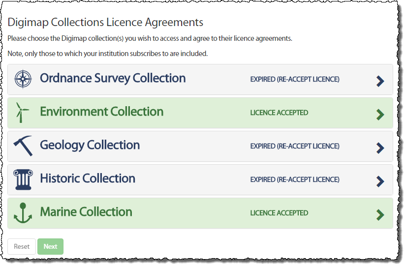
We are now at the start of a new academic year and Digimap has new licence agreements in place for the Ordnance Survey, Geology and Historic Map and Data Collections. You may have noticed already that you have been asked to agree to the licence again when you logged in. This is because some of the terms are different and you are required to agree to these new terms prior to accessing the data within the service.
When you login you will notice the Licence Agreements button at the top right of the home page.
Clicking on this will allow to you to view the licences you have agreed to and to agree to those you have not yet agreed to.
If a Collection has a new licence, the applications (e.g. Roam and Data Download) in that Collection will also appear grey. By trying to access an application which has a new licence, you will automatically be taken through the process of agreeing to it if you have not yet done so.
All you need to do is accept the licence and restate your purpose for using the service (which may or may not have changed since you agreed to the previous licence) and you will have access to the service once more.
If you have any questions or need any help or guidance have a look at the Agreeing to Licences for Digimap Collections section half way down the following help page:
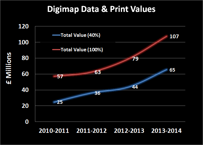
As part of our work to demonstrate the value for money of the Digimap Collections, EDINA has calculated the commercial cost of all the data downloaded and maps created for printing. We calculated the values per institution for the period August 2013 to July 2014 then totalled them; this came to approximately £65.4 million. This estimate is a conservative one because we reduce the quantity of data downloaded by 60% to account for duplication. When all the maps printed and data downloaded were included in the calculation (i.e assuming users would continue to take their own data and maps, and not share them) this total rises to over £107 million.
Click to enlarge image
We know that some data is downloaded multiple times within an institution, for example by students for a class exercise or by researchers for specific study sites. We found that on average only 40% of the data taken from Digimap over a period of time was unique within an institution. We believe that if institutions were paying commercial rates for their data they would be more likely to download it once and circulate it to those who need it; this is why we reduce the amount of data included in our calculation. However, there is considerable variation between institutions as to how much is unique; those that do more research or are smaller in size tend to have a greater proportion of unique downloads, so we calculated the 100% figure as a ceiling value.
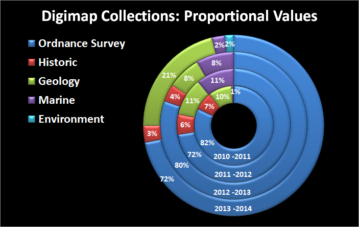
In total, over the past four academic years over £306 million (£170 million at 40%) worth of print maps and data has been served up from Digimap to subscribing institutions. The steep increase in 2013-14 was caused by more Ordnance Survey products being downloaded and printed than ever before and also by the high commercial costs of several products added to the Geology Digimap service.
How the Costs are Calculated
Click to enlarge image
The costs used in our calculations for the data come from the list prices published by data suppliers, and include any relevant multipliers or discounts declared publicly on their websites.
The data costs we calculated are done on a per product / per institution basis, with the data preparation and licensing charges assigned only once per product, per institution (rather than per data request). Many of the data collections are commercially licensed based on the number of users who have access to the data; with increasing numbers of users a multiplier is applied to a base cost. We applied the relevant multipliers according to the number of active registered users for each Collection at an institution.
We capped data costs at the price of national coverage for each product, making it impossible to assign greater cost for any one product than it would be to supply the entire dataset for use by a whole institution.
The values for the print maps (including saved maps in all Roam applications) are calculated by finding the cheapest commercially available map prints from websites such as eMapsite, NLS and FiND.
What We Didn’t Include
Click to enlarge image
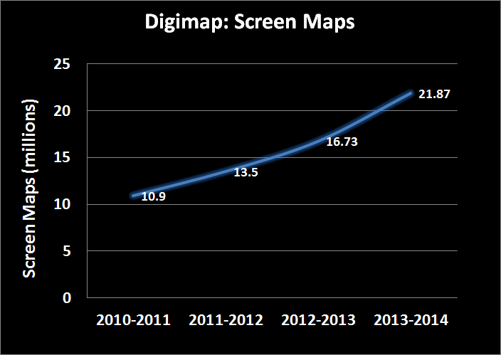
No monetary values were assigned to the millions of screen maps that are produced from Digimap. The value calculated also doesn’t take into account any of the help materials, training courses and support facilities that are all part of the Digimap service.
No OpenData downloads or maps created from OpenData are included in the calculation, despite the advantages of producing them from Digimap rather than other websites.
However, the biggest saving that isn’t included in these value calculations is your time. We only charged the data supplier’s preparation and licensing costs once per product or order, in line with each company’s policy where it applied. In reality there would be many orders occurring throughout an academic year as new research questions are raised. This all costs time, time which the data suppliers will charge for or that institutional staff would have to take to submit requests for data and time for staff to create and manage a repository for spatial data.
With 24 hour access to high quality data and maps through a purpose built mapping and data download interface, Digimap does all this work for its subscribers.
Over the coming weeks we will be sending out each institution’s data cost calculations to Digimap site representatives. If you are interested in the commercial costs of the maps and data your institution has been using please contact your site represenative. If you are unsure who your site representative is, please contact us:
This year’s annual data update will take place at the beginning of September. There will be a refresh the following Ordnance Survey products:
MasterMap Topography and ITN Layers
VectorMap Local
Meridian2
Strategi
MiniScale
Code-Point
Code-Point with Polygons
Boundary Line
1:250,000 Colour Raster
1:50 000 Colour Raster
1:25 000 Colour Raster
1:10 000 Raster
1:50 000 Scale Gazetteer
There will also be updated Hydrospatial data in Marine Digimap and a new version of the DiGMapGB-50 data in Geology Digimap.
Along with the new data Ancient Roam will be getting the Annotation Tools and there may be a bit of a surprise bonus addition to Digimap Roam. More information will be posted on the Blog, Twitter and Facebook page nearer the time.
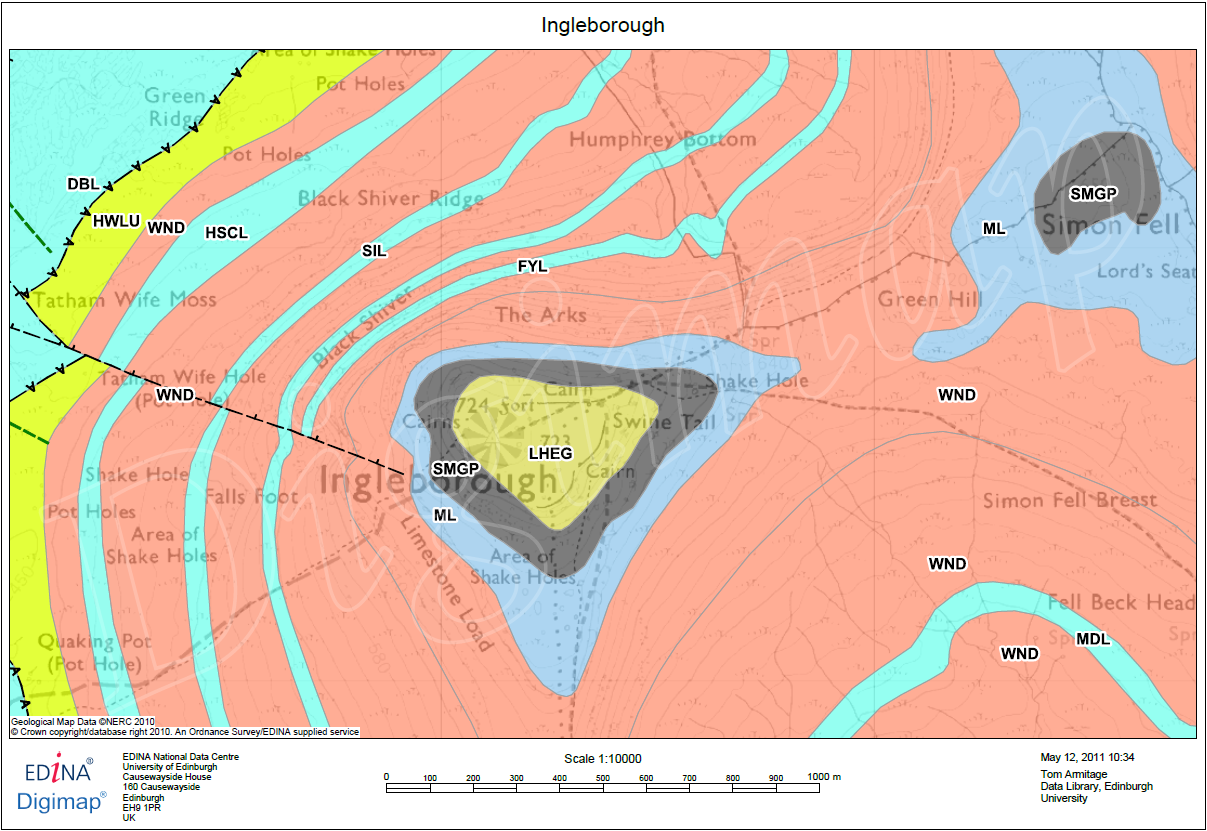
We have been working on a few improvements to Geology Roam and have now added rock labels to print maps and a new beta active legend.
Print Labels
The print labels show the lexicon code for each of the rocks on the map, therefore allowing you to identify them on a paper map and distinguish rocks with similar colours. The codes are placed in the centre of the area of each rock, if the rock area lies at the edge of the map then they are place in the centre of the area shown.
The labels are added by checking the box on the Print Map page. Below is a sample of what the maps look like, click on the thumbnail to view a full size image:
There is more information about the map labels in the printing section of the Geology roam help:
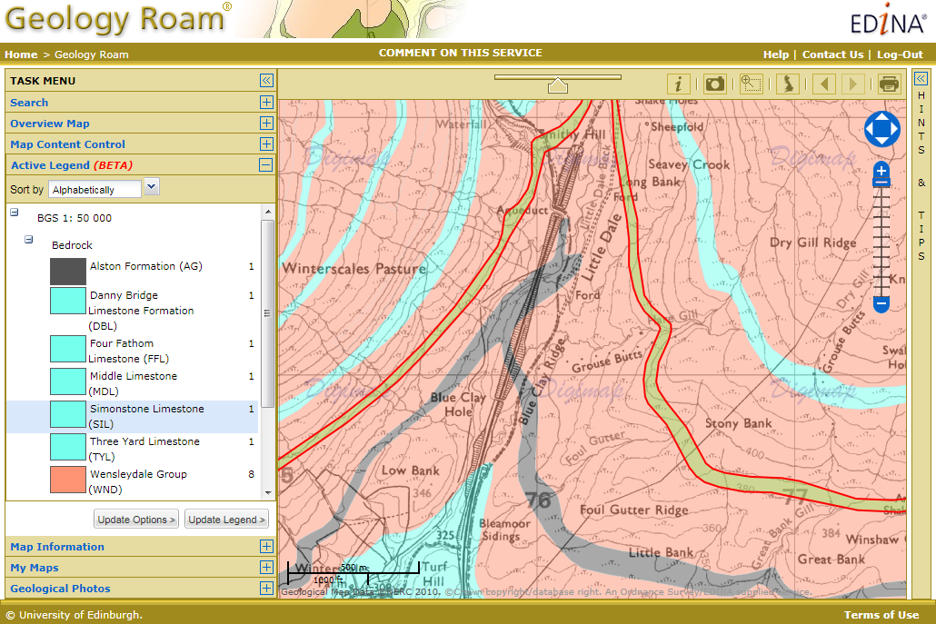
The active legend allows you to reorder the entries in the legend alphabetically or by the number units of that rock type. You can also click on the map to highlight rocks which will then be identified in the legend, this process works in reverse too, highlight rock on the map that have been selected in the legend. This functionality is still a beta version and we hope to extend the range of options available in the future. The image below shows the active legend at work, click on the thumbnail to view the full size image.
Instructions on how to use the Active legend can be found in the Geology Digimap Help pages:
We have implemented a new Help system for the Marine and Geology Digimap collections (Marine Help and Geology Help). The Help pages have been moved to a new production system which will make is easier for us to keep them more up to date and allow you to find the information you are looking for more easily and print better looking pages.
Visually there is not much change to the pages but over the coming months we will be updating and revising the content of the Help pages within Digimap to provide users with improved access to information about the Digimap facilities, the data available and how to use the data in different systems.
If you have any comments about the new Help pages or suggestions please let us know.
Tip: if you want to search for a phrase put it in quotes e.g. “zoom to position”
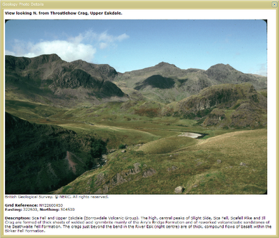
Geology Roam now allows you to view British Geological Survey images (of geological features, rocks, fossils and the BGS at work) from the JIDI Image Collection. The images area accessed via the map interface when you are zoomed in to the most detailed geology maps.
There are over 3000 images mainly found in geologically rich areas such as Cumbria, North and South Wales, the Dorset coast, Edinburgh etc. The images cover a wide range of features from details of bedding planes and large crystals in rock faces to aerial photographs of valleys showing glacial erosion features.
To access the photos go to one of the 5 most detailed zoom levels in Geology Roam and click on the camera icon in the tool bar or Geological Photos tab. You can then pan around the maps till you find an area with some photos.
The photos are marked on the map at the location they were taken from; click on the markers to see thumbnails of the image(s) for the location. You can view a full sized image with detail about what is shown by clicking on the thumbnail.
These photos are useful for geologists but there are also some spectacular landscape images that can be enjoyed by everyone.
EDINA has released Geology Roam; a new mapping facility within the Geology Digimap Collection. Geology Roam is based upon the Roam mapping facility from Digimap’s OS Collection and includes standard features such as fixed scale map views, ‘slippy maps’, map content customisation, searching by place name, postcode and grid reference, bookmarking and comprehensive help.
Geology Roam contains BGS DiGMap-625, DiGMap-250 and DiGMap-50 geology datasets and Ordnance Survey backdrop mapping. The geological data includes bedrock, superficial deposits, mass movement and faults.
Key features of Geology Roam include the ability to decrease/increase the opacity of the geology data over the Ordnance Survey back-drop map. A single click on the map will query the geology data and display details about the bedrock and any superficial deposits found at that point.
Geology Roam features a new printing interface that will become standard in all the Roam mapping facilities across Digimap. The new printing interface enables you to resize and reposition the map, and to add a map title and National Grid lines.
Beta Service
Currently available as a BETA service, we encourage you to give us feedback on the usability of Geology Roam so that issues you raise can be factored into ongoing development over the coming months. As well as responding to any issues you report, the following additional functions will be introduced:
Geological area (polygon) highlighting when clicking to obtain feature information, to make it easier to identify the extent of any geological feature to which the reported information corresponds.
Map based links to a Geology Photography Collection (JIDI Images). Icons will appear over the geology maps to indicate the availability of geological feature photographs for that location. Click on the icon to view these photographic images within the Geology Roam application.
Introduction of the BGS Rock Lexicon as an Independent application Geology Roam will run in parallel with the existing Geology Mapper during the Beta phase, after which Geology Mapper will be withdrawn (Dec 2010).
The existing mapping application will be withdrawn in December 2010 and will be wholly replaced by Geology Roam.
EDINA would welcome feedback on the service and on these proposed developments. Please contact us on edina@ed.ac.uk or 0131 650 3302.
Yesterday, Tuesday 26 January 2010, some changes were made to Digimap. These are detailed as follows:
1. Classic removed from Ordnance Survey Collection.
As advertised on 5 October 2009 and 6 January 2010 this old facility has been removed and replaced by the new Roam facility. You can find a demonstration of Roam on the EDINA website: Roam demonstration
2. Historic Digimap “preview map sheet” button has been removed.
This function used out-of-date technology to render the original historical map sheets in the browser window. It was extremely slow and was dependent upon software installed on a machine which is being decommissioned. It is much quicker and more user-friendly to download the map sheet required and view it locally.
3. Marine Digimap Hydrospatial data updated.
The 2009 version of SeaZone’s Hydrospatial data is now available through Hydrospatial Download. Late delivery of the data has meant a delay of the release from September 2009 to January 2010.