Digimap Roam: Printing PDFs from Chrome

We are getting a few reports from users experiencing issues when printing PDF maps using Chrome web browser. Unfortunately, the map watermark and any semi-transparent annotations are being printed as solid filled features. We have discovered that this occurs when the PDF is viewed and printed from within the Chrome browser, using Chrome’s in built PDF plugin.

We have investigated this problem and discovered that the bug is with Chrome and occurs with all PDFs with semi-tranparent layers not just those created by Digimap. The problem only happens on Windows computers with versions of Chrome released since the end of April (Chrome 34.0.1847 onwards).

Digimap users with Chrome should see a warning when they open the Print… window, informing them about the problem.

Print interface showing chrome alert

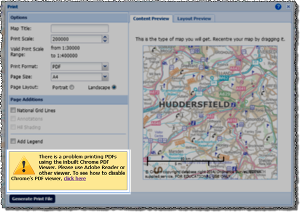
As the alert message suggests you can disable the plug-in to prevent it from opening PDFs or you can use the following workaround.
Printing from Chrome alternative method

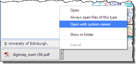
  • Create your printable map as normal it will appear at the bottom of your web browser.
  • Don’t click the file name to open the PDF, click the little arrow and choose ‘Open with system viewer’.
  • Providing it is installed on your machine, the map will open in Adobe Reader which will print the semi transparent layers correctly.

We hope that the issue is resolved by Google who develop the Chrome browser, it has been reported to them. Should you wish to disable the plug-in entirely then you can follow the instructions with the image below. You can also download the map as a file to your computer, and then open it directly with Adobe Reader, this is usually the best option anyway as it allows you to print the PDF multiple times or store it if you don’t want to print it just yet.

Disabling Chrome PDF plugin

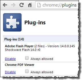
  • Type Chrome://plugins into the web address bar in chrome, this opens a list of all the plug-ins you have installed for Chrome.
  • Scroll down to the Chrome PDF Viewer on the Plug-ins page and click on the blue “Disable” link.
  • You will no longer have the option to view PDFs in the web browser.
  • Use this page to reactivate the plug-in if you want to reverse the change in the future.


If you need any assistance with opening your PDF map, please contact the EDINA helpdesk:

  • Email: edina@ed.ac.uk
  • Phone: 0131 650 3302

Historic Digimap: Printing options improved

Ancient Roam in Historic Digimap has had its print options updated so it now has the same set of options as the other Roam facilities. The two big changes to note are that you can now print up to A0 and that you can print a single county in areas where several overlap.

Until this change was made it was impossible to print an area with overlapping maps without printing all the counties available rather than just the one(s) you were viewing on the screen. Any print files now generated in areas with overlapping counties will only show those which are displayed on screen.  This allows you to have the control over how much information is on your map and to make the decision to show more or less information.

Overlapping Counties Print from Amcient RoamSingle County Print from Ancient Roam

Sometimes it can be an advantage to show multiple counties as even though the sheets overlap the actual map information doesn’t. However in the example above you can see how the counties overwrite each other in the map on the left and so produce a very confusing and fairly useless result; by switching one county off you can produce a much clearer print map such as the one on the right. [Click on the images above to view larger versions of the maps.]

The ability to print maps up to A0 brings Ancient Roam into line with the other Roam facilities so you can now print at this very large size in any Digimap collection.


Digimap Roam gets Carto features

We have introduced a raft of new print options to Digimap Roam;  some of these were previously only available in Carto, others are new altogether:Select your print scale in Digimap Roam

Select your own scale for the printed map (within sensible limits)
Print OS MasterMap at up to 1:100 scale (Carto’s limit is 1:500)
Print at paper sizes up to A0
Print landscape or portrait orientations (not available in Carto)

The new print options along with the formats already available mean that printing from Roam is now more flexible and powerful than Carto.

We have also added an extra zoom level to Roam’s screen maps called Building View. This shows OS MasterMap at around 1:500,  making it easier to add detailed annotations such as new buildings to your map.

OS MasterMap Views in Digimap Roam
© Crown copyright/database right 2013. Ordnance Survey/EDINA supplied service.
FOR EDUCATIONAL USE ONLY
Scales shown are the default print scales, screen map scale varies depending on the pixel size of your monitor / device.

With these enhancements Roam can now perform many of the tasks previously only possible with Carto.

Unfortunately, Carto has become difficult to maintain and needs to be replaced. These changes to Roam, along with some extra features planned for the coming months, will enable it to take the place of Carto. Once all the enhancements to Roam are made we will retire Carto completely; we intend to do this at the end of July 2013.

If you have any concerns about the withdrawal of Carto then please let us know:

  • Email: edina@ed.ac.uk
  • Tel: 0131 650 3302

High Quality PDF Printing For Ancient Roam

You can now download high quality PDF maps from Ancient Roam for printing.  This element of the service has been quite tricky to implement, so until now we have only had the save image button  to get a PNG image of the map you are viewing.

Now you can use the print button  to access a similar interface to the ones found in all the other Roam services.  You can see a sample PDF by clicking on the thumbnail below:

The Round Tower, Windsor Castle
A Sample PDF from Ancient Roam.

There are still a couple of options to add into Ancient Roam print maps; we need to add the ability to print 2up maps and the ability to switch off counties in areas where there are overlapping maps. Look out for these arriving in the near future.

Information about how to use all the features of Ancient Roam can be found on the following help page:

How to Use Ancient Roam

More Improvements Added 28th June

Service "At Risk".Some of the features mentioned in the previous blog post will be added into the services tomorrow, Tuesday 28th June:

More Improvements Coming Soon

Due to this work there will be some short Disruptions to all the services between 17:30 and 18:30. We hope you find the new features useful, please let us know if you have any feedback:

Mailto: EDINA help desk

or call us on: 0131 650 3302

More Improvements Coming Soon

We have had another very busy month and so a new batch of improvements for the Digimap services will be coming soon.

Printing in Ancient Roam

At the moment downloading data or saving screen images are the only ways to use the maps available in Historic Digimap once you have logged out.  Soon you will be able to create and save high quality PDF maps from Ancient Roam for use offline. We hope you will find this a much better way to get the best quality mapping out of the service.

Ancient Roam PDF
A sample image of what a PDF from Ancient Roam may look like.

New Data in Digimap Roam

Since the arrival of the Ordnance Survey’s latest large scale product, VectorMap Local,  we have been busy thinking of the best way to include it in the Digimap Roam. We have decided to use it to create four new representations available at two different scale levels.

Here is a quick look at what the four different representations might look like:

VML standard
Vectormap Local- Standard
VML Streetview
Vectormap Local - Streetview
VML Plan
Vectormap Local - Plan
VML Raster10k
Vectormap Local - 1:10,000 Raster

We haven’t stopped there either; we are also going to add in Line Drawing style mapping to the two most zoomed in levels; for those who like their MasterMap plain and simple, similar to planning application maps.

MasterMap - Plan
MasterMap - Line Drawing

You will be able to select the different views from the Map Content Control Tab using a drop down list.Alternate representations choice Menu

For more information about VectorMap Local look in the Digimap help pages as it is already available for download:

OS Products: OS VectorMap Local

Annotation Tools in Geology Roam

For those of you who have tried the annotation tools in Digimap Roam it will come as no surprise that we are very pleased to announce that we are now working on adding the same functionality in Geology Roam. Again the annotation tools are a first draft and will have exactly the same functionality as Digimap Roam’s tools.

Geology Annotation Tools

Once they are released we’d really like to hear from you about which functions you use and what else you would like added. We are already hoping to add in some Geology Mapping symbols for you to add to the maps.

As an added bonus we are also putting in the measurement tools so you can measure areas and distances too, so you can tell how long a fault is or what area is covered by different rock types.

Geology Roam gets enhanced print maps and a new Active Legend.

We have been working on a few improvements to Geology Roam and have now added rock labels to print maps and a new beta active legend.

Print Labels

The print labels show the lexicon code for each of the rocks on the map, therefore allowing you to identify them on a paper map and distinguish rocks with similar colours. The codes are placed in the centre of the area of each rock, if the rock area lies at the edge of the map then they are place in the centre of the area shown.

The labels are added by checking the box on the Print Map page. Below is a sample of what the maps look like, click on the thumbnail to view a full size image:

Geology PDF showing labels

There is more information about the map labels in the printing section of the Geology roam help:

How to use Geology Roam: Printing

If you are using Safari use the following link and then use the index to get to the Printing section:

How to use Geology Roam

Active Legend Beta

The active legend allows you to reorder the entries in the legend alphabetically or by the number units of that rock type.  You can also click on the map to highlight rocks which will then be identified in the legend, this process works in reverse too, highlight rock on the map that have been selected in the legend. This functionality is still a beta version and we hope to extend the range of options available in the future. The image below shows the active legend at work, click on the thumbnail to view the full size image.

Active Legend in Geology Roam

Instructions on how to use the Active legend can be found in the Geology Digimap Help pages:

How to use Geology Roam: Active Legend

If you are using Safari use the following link and then use the index to get to the Active Legend section:

How to use Geology Roam