Any views expressed within media held on this service are those of the contributors, should not be taken as approved or endorsed by the University, and do not necessarily reflect the views of the University in respect of any particular issue.
Digimap is an online map and data delivery service, available by subscription to UK Higher and Further Education establishments. Operated by EDINA at the University of Edinburgh, Digimap offers a number of data collections, including Ordnance Survey, historical, geological, aerial photography, LiDAR, marine maps, land cover mapping, global mapping and census data. For more information about Digimap go to our website: https://digimap.edina.ac.uk Background image Contains OS data (c) Crown Copyright and database right 2022
Webinar: A Walk Through Digimap Services
Join us for “A Walk Through Digimap Services”— a free, live webinar introducing you to Digimap’s powerful tools and features. This session will cover from an overview of map collections and navigating the platform to how to select and download your data. A live Q&A will follow to answer all your questions.
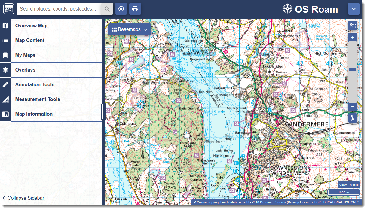
EDINA is very pleased to announce that Digimap Roam will be updated on Thursday 17th May 2018 to the new version currently available as beta. This change will apply to all Digimap Collections. The beta version has been available since November 2017 and as a result of feedback we have continued to improve it, adding some useful new features:
A “locate me” button – puts a pin on the map according to your current location
A “coordinate capture” tool – under Map Information, allows you to click a point and copy/paste the coordinates into other applications
A Variable width side panel to offer a larger map window
We are very excited about the new Roam, which has a fresher feel and a more modern look; it’s tablet-friendly with tools that are easier to find and use. All the main functions are located in the top left hand area, with a pull-out side panel ensuring maximum visibility of the map.
The new version of Roam will appear at the top of the list of applications in each Collection and will be labelled “Updated”. The previous version for each Collection will still be available until 31st July 2018:
We will be running a webinar about the new version of Roam on Wednesday 23 May from 1- 2pm. You can register for this here http://edina.ac.uk/training-and-events. Places are limited, but the webinar will be recorded and available to view later on our YouTube channel. Help pages for the new version of Roam will also be available.
As ever, we welcome feedback on Digimap. Please don’t hesitate to get in touch using any of our social media channels or use our email address or telephone number:
We have now reached the end of the Lidar Digimap Preview. We hope that everyone who has used the service has found it a great way to access the Lidar data available. From now on the service will continue to be available to Digimap Users whose institution subscribes to the Aerial Digimap service.
Lidar Point Cloud Forth Rail Bridge. Crown copyright Scottish Government, SEPA and Scottish Water (2012).
Despite the addition of Lidar Digimap, Aerial Digimap subscription prices will not be increased for the 17/18 academic year. We will also be looking to add further datasets to Lidar Digimap over the next 12 months, these include:
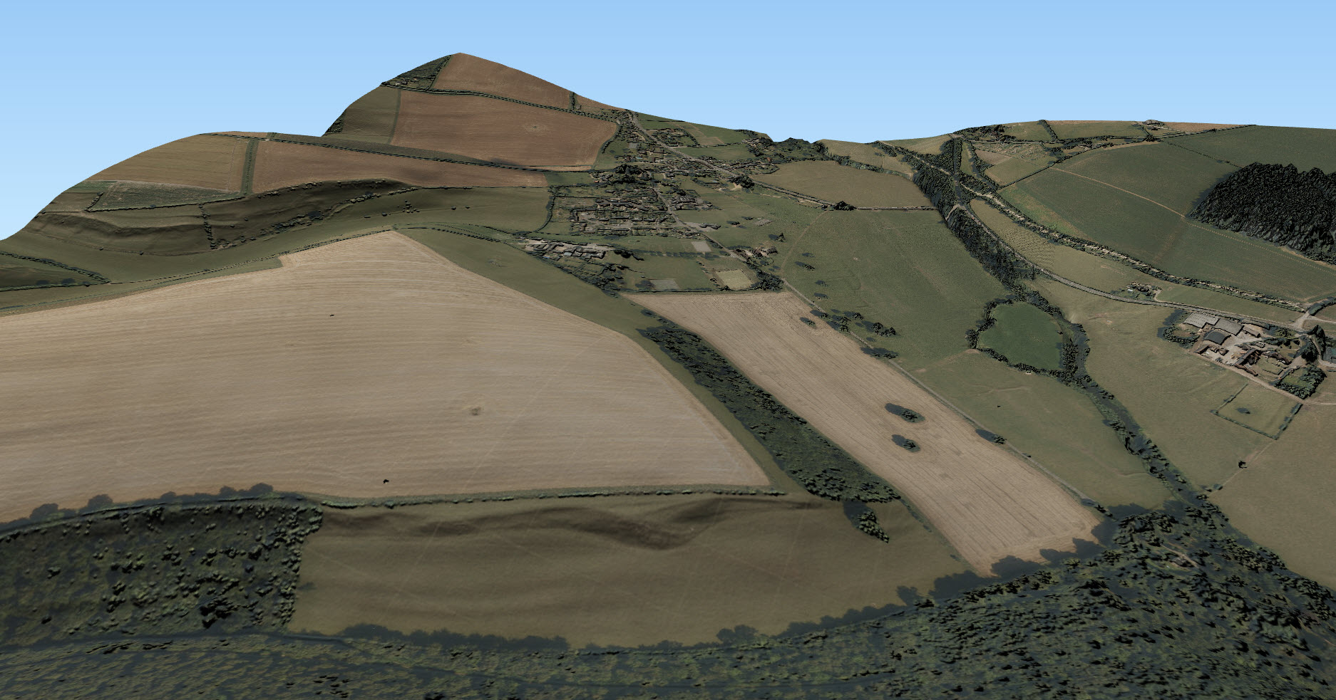
Additional Point Cloud datasets ideal for use in CAD software for creating 3D models like this one of the Forth Rail Bridge
Photography; aerial images captured at the same time as the Lidar data
We’d also like to thank the hundreds of people who took the time to fill in our user feedback survey on Lidar Digimap, we have seen a huge range of uses for the data across a very broad range of disciplines. This feedback exercise has been very successful and we will be making the draw to see who has won the Amazon vouchers very soon. Keep watching the blog for the announcement in the coming weeks.
If you would like any more information about the Lidar or Aerial Digimap collections or details on how to subscribe then please do not hesitate to contact us:
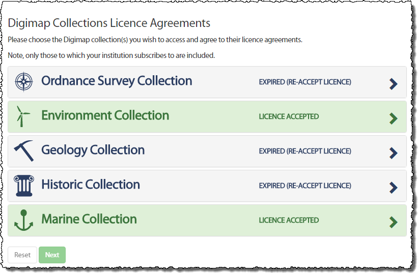
We are now at the start of a new academic year and Digimap has new licence agreements in place for the Ordnance Survey, Geology and Historic Map and Data Collections. You may have noticed already that you have been asked to agree to the licence again when you logged in. This is because some of the terms are different and you are required to agree to these new terms prior to accessing the data within the service.
When you login you will notice the Licence Agreements button at the top right of the home page.
Clicking on this will allow to you to view the licences you have agreed to and to agree to those you have not yet agreed to.
If a Collection has a new licence, the applications (e.g. Roam and Data Download) in that Collection will also appear grey. By trying to access an application which has a new licence, you will automatically be taken through the process of agreeing to it if you have not yet done so.
All you need to do is accept the licence and restate your purpose for using the service (which may or may not have changed since you agreed to the previous licence) and you will have access to the service once more.
If you have any questions or need any help or guidance have a look at the Agreeing to Licences for Digimap Collections section half way down the following help page:
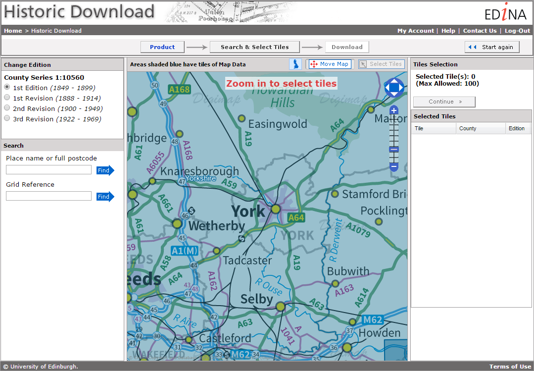
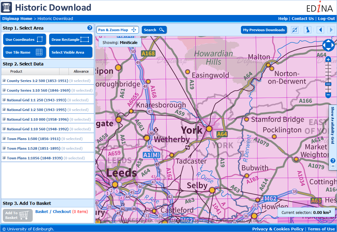
EDINA will be withdrawing the old Historic Download on Friday the 11th of December. With most people now using the new Historic Download we have taken the decision to switch off the old version to free up resources. The new interface contains all the same data but allows you to take multiple products and revisions in a single order. Existing users’ Download History from the old interface will NOT be available to reorder from the new interface so please make sure you have made all the necessary orders in the old interface before the 11th.
New Historic Download
Please note that if you want a definitive list of published dates for the maps you download from the new interface, it is available in the contents.txt file delivered in your zip folder with your data. This text file has the details for every tile / sheet of map data you have taken.
The old Historic Download was the last remaining download interface that was different to the other collections, so now every collection uses the same interface to retrieve data for use in CAD or GIS software.
We are introducing a new registration system in January (26th to the 28th) and would like to give advance warning of the service disruption this is will cause.
New users will not be able to register for Digimap from 4pm on 26th January
All Digimap services will be unavailable all day on 27th January
Normal service will resume on 28th January
New registrations for Digimap, using the current system, will be closed from 4pm Monday 26th January to ensure that no registrations are lost during the changeover. All Digimap services will then be unavailable all day on Tuesday 27th January, while we put the new system in place. Once all the work is complete the service will be available again hopefully by midday on Wednesday 28th January.
We apologise for the inconvenience caused but due to the significant changes required to release the new system we must close access to Digimap during this time. We urge you to create any maps or download data that you may need during the period of service unavailability in advance.
The new registration system will allow users to register and instantly access Digimap Collections via email verification speeding up access for new users significantly. We hope that this will help make up for the fact that new users will be prevented from registering during the maintenance. Existing registered and active users will not notice any change once normal service has been resumed.
If you have any questions or concerns please contact us:
Email: edina@ed.ac.uk
Phone: 0131 650 3302
More details about how the new system looks and works will be posted on the Digimap blog in the New Year.
EDINA will be making use of the “At Risk” period on Tuesday the 10th of June between 08:30 and 09:30. The service will be unavailable for a short time during this hour while we make some changes.
All Digimap services will be unavailable between 08:30 and 10:00 on Tuesday 28th of January, and should be considered “at risk” for the rest of the morning. We are carrying out an essential database upgrade, this affects logging into the service so there will be no access until the work is complete. We apologise for any inconvenience caused.
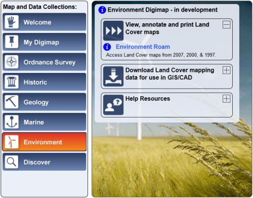
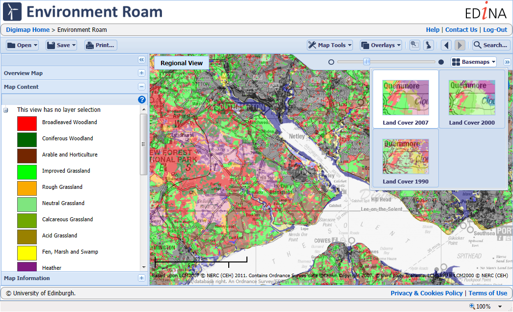
EDINA and Jisc are pleased to announce the launch of a new Digimap Collection, Environment Digimap.
This new collection offers land cover map data from the Centre for Ecology & Hydrology (CEH). Environment Digimap is a subscription service; however, it will be available free of charge until 31 July 2014. After this period a subscription fee will apply per institution.
Environment Digimap offers two facilities: mapping through Environment Roam, and the ability to download data through Environment Download. The data available, CEH’s Land Cover Map products, provide a snapshot of land cover for each of the years 1990, 2000 and 2007. There are raster datasets available at 25m and 1km resolutions for each year and a vector version of the 2000 dataset. The data are in a range of formats depending on the year. More details are available in the Environment Digimap Help Pages: CEH Products Available
How to get access…
To use this service for free your institution needs to subscribe, this is free till the end of the 2013 – 14 academic year and can be arranged via the Jisc Collections website:
If your institution doesn’t subscribe the Environment Digimap button on the home page will be grey. Contact your Digimap site rep and they will be able to help arrange your institutions subscription: List of Digimap Site Reps
If you have any questions about Environment Digimap, please contact us:
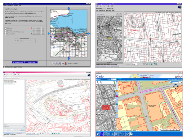
At 11:00 am access to Digimap Carto will be closed and by 12:00 noon it will have made its last map. Carto was at the cutting edge of web mapping technology for several years, delivering Ordnance Survey maps to thousands of users while Google was still just a search engine. The high quality EPS and then PDF print files it produced meant that staff, students and researchers could print out maps of anywhere in Great Britain and were no longer limited to their library’s collection.
Carto over the years 1998 to 2013
As time passed Carto could easily keep up with the latest offerings from MultiMap (later bought by Microsoft and eventually becoming Bing Maps) and Google Maps. It had more advanced tools and much better data in the form of OS MasterMap, so as the Java updates got more frequent we all put up with the software being a bit unreliable for a few days before we could issue a fix. However after 2011 the number of Java updates ramped up significantly and the changes became more difficult to accommodate. Once anti-virus software began seeing Carto as a potential threat and preventing it operating we decided that maintenance was unsustainable.
EDINA realised that continuing to support Carto would be too costly in terms of developer time spent fixing problems rather than improving and enhancing the service. In the meantime the rest of the world had become much more accustomed to viewing maps online in a web browser; EDINA’s other mapping service, Roam was able to take on much of what Carto was offering without confusing or frustrating its users.
Some recent changes to the capabilities of the web mapping platform that Roam uses meant that we could finally offer a Carto replacement without the need for any software to run on the end user’s computer. These changes have allowed us to withdraw Carto and let Roam to take on all the mapping duties for Digimap. We can now get on with the business of all those improvements and enhancements we have been wanting to make. We hope you will like the changes that we are aiming to have in place this August: