Any views expressed within media held on this service are those of the contributors, should not be taken as approved or endorsed by the University, and do not necessarily reflect the views of the University in respect of any particular issue.
Digimap is an online map and data delivery service, available by subscription to UK Higher and Further Education establishments. Operated by EDINA at the University of Edinburgh, Digimap offers a number of data collections, including Ordnance Survey, historical, geological, aerial photography, LiDAR, marine maps, land cover mapping, global mapping and census data. For more information about Digimap go to our website: https://digimap.edina.ac.uk Background image Contains OS data (c) Crown Copyright and database right 2022
EDINA will be withdrawing the old Historic Download on Friday the 11th of December. With most people now using the new Historic Download we have taken the decision to switch off the old version to free up resources. The new interface contains all the same data but allows you to take multiple products and revisions in a single order. Existing users’ Download History from the old interface will NOT be available to reorder from the new interface so please make sure you have made all the necessary orders in the old interface before the 11th.
New Historic Download
Please note that if you want a definitive list of published dates for the maps you download from the new interface, it is available in the contents.txt file delivered in your zip folder with your data. This text file has the details for every tile / sheet of map data you have taken.
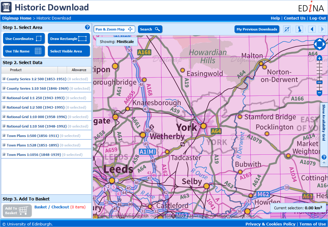
The old Historic Download was the last remaining download interface that was different to the other collections, so now every collection uses the same interface to retrieve data for use in CAD or GIS software.
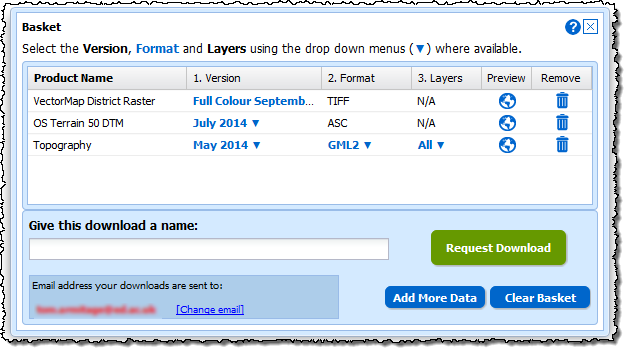
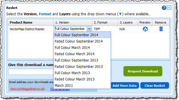
We have updated all the new style Download interfaces in Digimap to make it easier to change the options for the data you have selected. When you have added some data to your basket you can now see more clearly what can be changed; the version (date and style), the format and the layers.
Where these options are highlighted in blue with a ▼ next to them you can click them and get a drop down menu with the alternatives.
Make the changes you need, add a name, then click on the Request Download button to order your data.
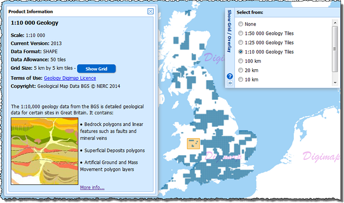
We have also made a slight change to the Product Information pages for some of the data products too. Where the data is available on tiles you can now click a Show Grid button to see the tile outlines on the map. When you make a selection on the map you will get all the grid tiles that are partially or entirely within your orange selection area.
This feature is particularly useful for data products like the 1:10,000 and 1:25,000 scale geology data and the Marine HydroView Charts, where the data isn’t a continuous coverage and your selected area may contain no tiles. When you click the Show Grid button it will also automatically open the menu from the right of the map which allows you to change the grid shown or switch it off.
Remember, you open the Product Information panels by clicking on the blue Info links in the list of data products to the left of the map.
Please let us know if you have any questions about these changes or anything else:
All Digimap Download facilities should be considered ‘at risk’ next Tuesday (26th April) due to some essential hardware maintenance. MasterMap Download will take longer to process orders on this day so it would be wise get these in beforehand if you have deadlines to meet.
On Tuesday 1st March, EDINA will be updating the metadata for the historical maps in Historic Digimap. The metadata changes will affect only the Scottish County Series maps and will mean that some maps will appear to “move decade”. More details of the implications of these changes are given below.
Accuracy of publication dates
When the maps were originally scanned, the detailed marginalia on the original paper map sheets was not captured at the same time. The marginalia contained information such as the survey year, publication year, re-publication year (if applicable) and surveyor name. During the digitisation process only one year from the marginalia was recorded; it is assumed this was the publication year but there was always some uncertainty around this.
A joint project between EDINA and the National Library of Scotland (NLS) was undertaken to digitise the marginalia of the original paper copies of the historical maps held by NLS. The metadata captured included the Survey Year and Publication Year. Until now, the survey year of all maps in Historic Digimap was unknown. We now have the survey year for a significant number (but not all) of the County Series maps for Scotland at both 1:2500 and 1:10 560 scales.
The significance of this project to Historic Digimap is that we can now use the more accurate and reliable publication dates for many of the County Series maps to improve the mapping and download facilities offered. In order to make use of the new NLS publication dates, these were matched with the original metadata using a series of rigorous database queries and manual processing.
How many maps have changed?
Consequently, around 35,000 County Series map tiles* (18%) now have survey years. Of these, around 28,000 tiles also have a more accurate publication date. In the majority of cases (over 70%) the publication date has only changed by a year or two. For nearly 2,000 tiles the change in publication date is more than 10 years, with the largest single change being 39 years. For those tiles which have not had updates to the survey year, the Landmark publication year used remains unchanged.
So what does this mean for Ancient Roam and Historic Download?
Nothing has changed in Historic Download in terms of how historical maps can be found and downloaded, but the updated publication dates will be reflected in dates provided on the order summary page in the downloader. These will be more accurate and reliable than previously.
For Ancient Roam, there are some more significant effects. The publication date is used to determine which maps are visible in each decade given in the timeline along the top of the map screen.
Many of the maps for which the publication date has changed by one or two years will remain within the same decade and therefore will not be affected. However, for some maps a change of a year or two in the publication date may be enough to shift the map from one decade to another. For example, a map previously thought to have been published in 1889 but now known to have been published in 1901, originally appeared in the 1890s decade but now appears in the 1900s decade.
Where there have been more significant changes in the publication date some have resulted in entirely new decades being available in the timeline for particular areas. For example, in Forfarshire there were two County Series editions in the 1890s. This was because maps originally published in the 1860s and 1870s were re-published in the 1890s. So where no maps appeared for Forfarshire in 1860/70s, they do now!
Other maps with significant publication date changes tend to be odd outlying tiles that for some reason had a significantly different date from neighbouring tiles. This means that some odd ‘holes’ have been filled.
How do I find out the map date source?
In addition to the new survey and publication data information, the Map Details information box will also be updated. A new icon has been added to the tool bar to access the map information and the information box styling has been updated in keeping with the other Digimap Roam clients. Three new attributes have been added to the Map Details information: Year Surveyed (where applicable), Sheet Title (where applicable) and Date Source. The Date Source information will tell you whether the publication year came from the original Landmark data or the NLS metadata.
While these changes to Scottish County Series maps means that the per decade classification is now different, the changes mean that the dates are now more accurate. Our thanks go to the National Library of Scotland for their hard work on this project.
The updates to Historic Digimap will take effect on the evening of 1 March 2011.
*Map tiles refers to the ‘cookie-cut’ National Grid versions of the maps, not the original County Sheets
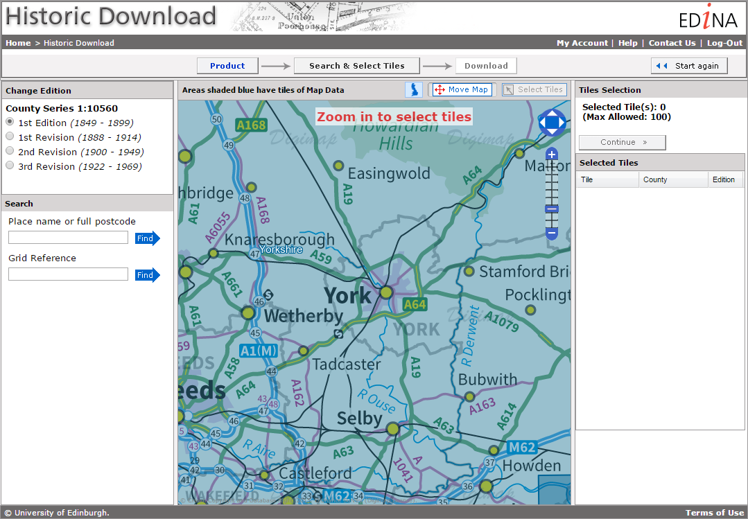
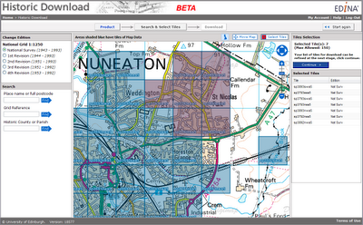
Launched as a BETA service on 20 April 2010, Historic Download is an entirely new facility allowing users to select and download larger quantities of historical map data.
The facility offers the capability to browse contemporary maps of the UK which have been shaded blue to indicate the coverage of historical maps of each series and edition. Areas of historical maps can be selected for download by clicking on the appropriate shaded polygons or by dragging a box to select multiple map sheets.
The interface has been designed to improve selection and retrieval of larger quantities of data for research projects. Build up a list of the data you need, choosing maps from different editions of a given product and take up to 200 maps in a single download.
EDINA welcomes feedback on this BETA service. You can contact us on edina@ed.ac.uk or 0131 650 3302.