Any views expressed within media held on this service are those of the contributors, should not be taken as approved or endorsed by the University, and do not necessarily reflect the views of the University in respect of any particular issue.
Digimap is an online map and data delivery service, available by subscription to UK Higher and Further Education establishments. Operated by EDINA at the University of Edinburgh, Digimap offers a number of data collections, including Ordnance Survey, historical, geological, aerial photography, LiDAR, marine maps, land cover mapping, global mapping and census data. For more information about Digimap go to our website: https://digimap.edina.ac.uk Background image Contains OS data (c) Crown Copyright and database right 2022
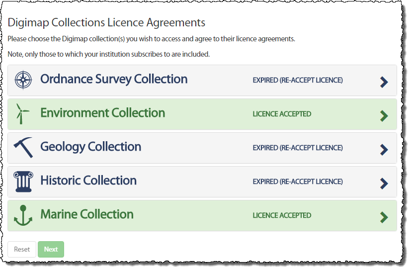
We are now at the start of a new academic year and Digimap has new licence agreements in place for the Ordnance Survey, Geology and Historic Map and Data Collections. You may have noticed already that you have been asked to agree to the licence again when you logged in. This is because some of the terms are different and you are required to agree to these new terms prior to accessing the data within the service.
When you login you will notice the Licence Agreements button at the top right of the home page.
Clicking on this will allow to you to view the licences you have agreed to and to agree to those you have not yet agreed to.
If a Collection has a new licence, the applications (e.g. Roam and Data Download) in that Collection will also appear grey. By trying to access an application which has a new licence, you will automatically be taken through the process of agreeing to it if you have not yet done so.
All you need to do is accept the licence and restate your purpose for using the service (which may or may not have changed since you agreed to the previous licence) and you will have access to the service once more.
If you have any questions or need any help or guidance have a look at the Agreeing to Licences for Digimap Collections section half way down the following help page:
We are often asked whether Ordnance Survey maps from Digimap can be published on the web and whether the Digimap licence allows this. The simple answer is yes, but there are (as always) caveats. The most obvious one is that any maps from Digimap that you publish on a website must relate to your academic work. That applies to the use of Digimap, regardless of what you do with the maps or the service.
The section of the Ordnance Survey Licence you need to look at is Schedule 2 of the Second Variation Agreement. This was originally called Appendix 4 under the original 2007 – 2009 licence, but has since been superseded by the first and second variations. You can find all the licence documents online here:
If you wish to publish a static image on your public-facing, “open to the world” website, you may do so on condition that the image is no bigger than 1 048 576 pixels. This is the equivalent of a square 1024 x 1024 pixels.
If you wish to publish a static image on an intranet page, that is, a website with access restricted to members of your institution, there are no restrictions on the size of the image you can use.
You can publish as many images as you wish, as long as each one is less than 1 048 657 pixels (1024 x 1024 or equivalent).
Interactive Mapping
A more common and complex question is whether you can put up a “zoomable” map with your own data overlaid on it. If this is what you wish to do, you need to consider the following stipulations in the licence:
When rendering mapping on a website:
Only Digital Maps may be published. Digital Data and mapping in GeoPDF format may not be published at any time.
It must only be available as an image and not be accompanied by drawing or measuring tools.
It is permissible to zoom in and out to enlarge or reduce the viewing scale of a discrete map image but not to change from one dataset to another of higher/lower resolution.
It is permissible to pan to the edge of a discrete map image (where the ‘viewing frame’ is smaller than the overall image).
Digital Maps may be displayed at any size on screen.
More than one Digital Map may be included but no single Digital Map may be of a size greater than specified above.
Note that “Digital Maps” is a capitalised term and is specifically defined in the licence agreement. The definition given is: “any or all of the maps created by a Datacentre from the Licensed Work to be used in a Service provided by a Datacentre.” In essence this means any map created by Digimap which is “non intelligent”. That is, it contains no vector data, cannot be interrogated to extract data of any sort (in the same way as one might interrogate a satellite image to identify the spectral signature of a particular pixel), and is a dumb image.
Given these stipulations, you are not permitted to use the Ordnance Survey licensed data available through Digimap to display a series of maps using different OS data products which the public can zoom in and out of, pan around the whole country and add their own markers to, in a similar way to many other online mapping services (such as Google Maps or Apple Maps or OpenStreetmap). Note that this does not apply if you wish to use the OS OpenData, which is also available through Digimap.
Alternative Sources of Mapping
If you do wish to create an interactive mapping function on your website, you might like to consider the alternatives to using licensed Ordnance Survey data. EDINA operates a free service called OpenStream which provides OS OpenData through an API. You need an academic email address to register for OpenStream (ending .ac.uk) , but it doesn’t cost. The maps area available under the OS OpenData licence and the licensing terms are therefore much more flexible than the data licensed through Digimap.
As ever, if you have any questions about what you can and cannot do under the Digimap licence, please do not hesitate to contact EDINA with details of what you wish to do, what data you wish to use and who you intend should benefit from your work. We are keen to hear of licensing questions you would like to see explained further on this blog.
Remember that you need to renew your institution’s subscription to Digimap’s Ordnance Survey Collection BEFORE 30 September 2009 in order to ensure continuity of service.
If your institution has not completed and returned the appropriate licensing forms by this date, access to Digimap’s Ordnance Survey Collection will be removed.
Owing to the way access is controlled under the UK Federation there will be no exceptions to and no leeway given for this date. If you have already requested an invoice, you still need to return the subscription forms to the address supplied on the forms by 30 September 2009.
On 1 August 2009, the Ordnance Survey Data Sub-Licence Agreement was extended and amended by a Variation Agreement. If institutions wish to continue their subscription to Digimap’s Ordnance Survey Collection, the Variation Agreement must be signed and returned by Wednesday 30 September 2009. Institutions not submitting renewal forms by this date will have access to the service removed. There will be no exceptions to this. Details of how to re-subscribe are given on the JISC Collections website.
When an institution re-subscribes to Digimap’s Ordnance Survey Collection, it agrees to the terms of the Ordnance Survey Data Sub-Licence Agreement AND the Variation Agreement. Some of the clauses in the Sub-Licence Agreement are superseded by those in the Variation Agreement. Both documents must be read in conjunction with one another, since one is not valid without the other.
EDINA has drawn up a set of Frequently Asked Questions to help you understand what the the Sub-Licence and Variation Agreements will permit in terms of map and data usage. These can be found at: http://edina.ac.uk/digimap/support/faq_oslicence.html
The following is a summary of the changes which are brought into effect on 1 August 2009 by the Variation Agreement. The original Sub-Licence Agreement holds good unless it has been amended by the Variation Agreement. Please read the Variation Agreement itself for full details of the amendments.
The definition of Authorised User has changed. An individual must fulfill three conditions in order to be an Authorised User. Individuals must:
be a student of, staff (both current or retired) of, or visitor to an Authorised Institution
be authorised by an Authorised Institution to access the Authorised Institution’s electronic information services via secure authentication; and
be registered with EDINA Digimap
Overseas Students are also specifically excluded from being Authorised Users, unless they are resident within the UK. Check the wording of the Variation Agreement carefully. Note also that it is the institution’s responsibility to ensure that students who are not eligible for access to this service are not given the means to access it. Under the UK Federation, EDINA is not able to check eligibility.
All references to Athens have been superseded by references to the UK Access Management Federation.
Class Registration is no longer possible. This has been the case since the introduction of the UK Access Management Federation in August 2008, but has now been formalised in this Variation Agreement. Assigning one username to more than one individual (as per a Class registrations) is not permitted under UK Federation policy.
Authorised Users are now explicitly permitted to share data with other Authorised Users, either in the same or another Authorised Institution. This was previously implicit, but has now been made explicit. Sharing data between Authorised Institutions is still subject to completion of the Transfer of Data form as specified in the original Sub-Licence Agreement (Schedule 7, section 8.1)
The Permissible Publication Sizes have been amended. These now offer a significant improvement on the previous restrictions to the size of maps published. For example, it is now possible to publish a map of Great Britain in electronic format. Please read Schedule 2 of the Variation Agreement for specific details of the new rules.
Two new datasets have been included in the agreement: MiniScale® and the 1:250,000 Scale Colour Raster. A full list of products available can be found on the EDINA website.
Both the Sub-Licence Agreement and the Variation Agreement are available from EDINA’s website:
Questions regarding the subscription process and the licence agreements should be directed at JISC Collections. Questions relating to the Digimap service should be directed at the EDINA Helpdesk.
I’ve been asked to provide my institution’s “Digimap Licence Number”. Where do I find this?
There is no such thing as a “Digimap Licence Number”. If you need a specific licence number, we would suggest the OS Educational Copyright Licence number is the most appropriate one to use.
This licence is arranged directly between the institution and Ordnance Survey and therefore doesn’t relate to Digimap specifically. Institutions can hold an OS Educational Copyright Licence without having a subscription to Digimap, although the licence is required in order to take out a subscription to Digimap.
A copy of the licence (on which you will find the licence number) is held by your institution and the licence number is submitted with your institution’s Digimap subscription forms, which are sent to JISC Collection’s subscription agent. Ordnance Survey will also have a record of it.
Lorraine Estelle, CEO of JISC Collections, has issued the following as an email to all institutions subscribing to Digimap’s Ordnance Survey Collection. EDINA will also be distributing this information to site representatives and other support staff.
The current Ordnance Survey Licence Agreement for Digimap ends on 31st July 2009. Ordnance Survey and JISC Collections are working on the renewal of licence which will cover the period from 1st August 2009 to 31st July 2014.
Although the new Licence Agreement is not yet available from the JISC Collections’ website, the subscription fees for first year of the new Agreement from 1st August 2009 to 31st July 2010 are confirmed: in light of the current economic situation the subscription fees for this period will remain at the current level, with no retail price index increase.
JISC Collections will be consulting with users about a new subscription model from 1st August 2010, which it hopes will enable more institutions to afford the other datasets available from the Digimap Collections: Historic Digimap, Marine Digimap and Geology Digimap. The consultation will commence in the autumn of this year.
Given that the pricing model for 1st August 2010 to 31st July 2014 is uncertain until the consultation is complete, institutions signing the new Licence Agreement for 1st August 2009 31st July 2014, may opt-out at 31st July 2010 if they need to.
Reminder of new licence agreement
A new, three-year sub-licence is now available for Historic Digimap, the service offering historic Ordnance Survey maps and data from the Landmark Information Group. Current subscribing institutions will be contacted directly to ensure continued access from 1 August 2008 onwards. The new licence will run from 1 August 2008 until 31 July 2011. Full details, including subscription forms and costs, can be found on the JISC Collections website at: http://www.jisc-collections.ac.uk/catalogue/coll_digimap_historic.aspx
Trials
In addition, 30-day trials are offered to those from institutions wishing to assess the service prior to subscription. Please contact the EDINA Helpdesk on edina@ed.ac.uk to request such a trial. You can read more about Historic Digimap on the EDINA website at: http://edina.ac.uk/digimap/description/historic_overview.shtml
Consultation on additional datasets
JISC Collections are currently running a consultation for the purchase of additional datasets for Historic Digimap. Among the suggested purchases are the GOAD Fire Insurance plans and historical town plans.
Representatives from existing institutions and others interested in the Collection are invited to complete the short survey at their earliest convenience. This can be done online, and should take only a few minutes to complete:
If your institution subscribes to Historic Digimap, you should note that the current licence ends on 31 July 2008 and the new licence begins on 1 August 2008. Subscription costs for the next licence period are now available from JISC Collections website.
All subscription forms should be completed and sent to the JISC Collections Helpdesk. Details of the subscription process can be found on the JISC Collections “how to subscribe” page.
Please do not send subscription forms to EDINA.
Note also that from 1 August 2008 access to Historic Digimap will be via the UK Federation and OpenAthens.
Are you coming to the end of your course? Are you changing jobs and moving to a different University or College? Are you retiring? If so, there are some issues relating to the use of Digimap which you should be aware of.
IF YOU ARE GRADUATING, OR YOUR COURSE IS COMING TO AN END… …you will cease to be a member of a subscribing institution and therefore will no longer be a Digimap Authorised User. This means you must delete any data you hold from Digimap. You may keep paper maps (including those which form parts of reports, coursework and dissertations), but not digital data.
IF YOU ARE CHANGING JOBS OR MOVING TO A DIFFERENT COLLEGE OR UNIVERSITY…
…you need to check whether your new institution subscribes to any of the Digimap Collections. If your new institution is NOT a subscriber to a particular Collection, you may not retain any digital data from that Collection in your new job. If you wish to use Digimap in your new job, and your new institution is also a subscribing institution, you will need to register with Digimap using login credentials from your new institution.
IF YOU ARE LEAVING AN EDUCATIONAL INSTITUTION AND GOING TO WORK FOR A COMMERCIAL OR CHARITABLE ORGANISATION…
…you will cease to be a Digimap Authorised User. This means you must delete any data you hold from Digimap. You may keep paper copies of maps (including those which form part of reports or dissertations), but not digital data.
WHAT IFS…
There are some circumstances where you may continue to be an Authorised User, even if you are graduating, or leaving your current institution. If you are retiring, you may continue to have rights to access your institution’s electronic resources. If you are graduating from your first degree and staying at the same institution to undertake a PhD, you will continue to be a member of your institution and therefore eligible for access to Digimap. If you believe you should continue to have access to your institution’s resources, you should check with your Digimap site representative whether this applies to Digimap too.
The rules of eligibility apply to all Digimap Collections. These rules revolve around the definition of “Authorised User” as specified in the licence agreement for each Collection. You can find these on the EDINA website at: http://edina.ac.uk/digimap/terms.shtml
A NOTE FOR SITE REPRESENTATIVES… Access to any electronic resource relies on subscribing institutions maintaining authentication and authorisation systems effectively and efficiently. An example of good practice in this regard would be deactivating local user accounts when students graduate or leave your institution. You may wish to check what your local practice is.