Any views expressed within media held on this service are those of the contributors, should not be taken as approved or endorsed by the University, and do not necessarily reflect the views of the University in respect of any particular issue.
Digimap is an online map and data delivery service, available by subscription to UK Higher and Further Education establishments. Operated by EDINA at the University of Edinburgh, Digimap offers a number of data collections, including Ordnance Survey, historical, geological, aerial photography, LiDAR, marine maps, land cover mapping, global mapping and census data. For more information about Digimap go to our website: https://digimap.edina.ac.uk Background image Contains OS data (c) Crown Copyright and database right 2022
Following our survey in April to learn more about Digimap users’ data priorities for the future, we have some interesting results, with common themes emerging.
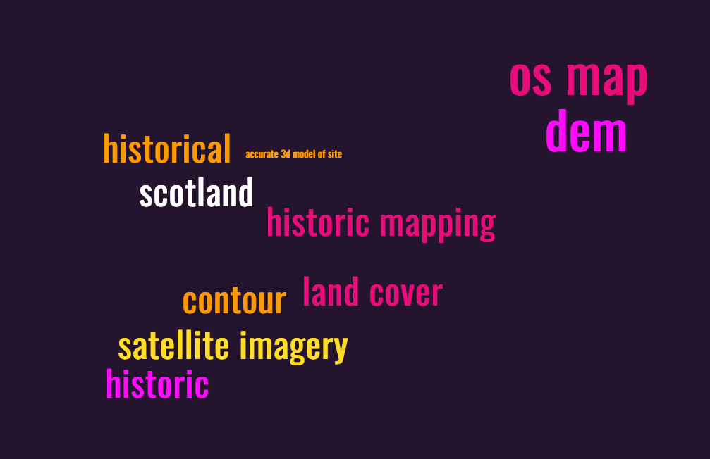
First priority datasets:
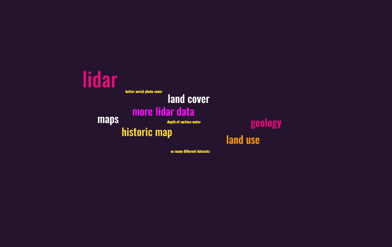
Second priority datasets:
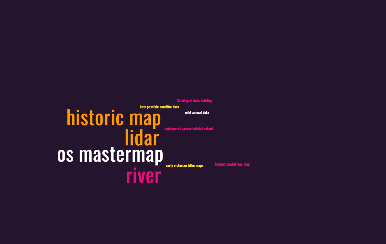
Third priority datasets:
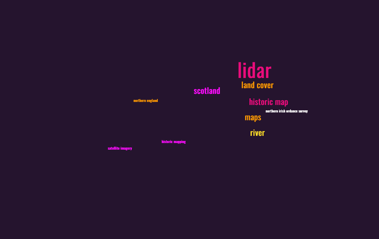
Combined, the three priorities look like this:
In summary, we think there is demand for more lidar data, more historical data and satellite imagery. We will continue to look at the detail of the survey and use the results to inform our pursuit of additional datasets for Digimap.
In the meantime, do explore what’s already there. Your institution may not subscribe to all the Digimap Collections but you can express your interest in those you don’t currently have access to by logging in to Digimap and following the prompts against each Collection. There is already a range of historical maps (OS, dating back to the 1840s), aerial photography (as much as is available from Getmapping Ltd at 25cm resolution) and Lidar data (originating from GB environment agencies), as well as a full range of DTM and DEM data, detailed OS topographical maps and land cover information. A complete list of all the data available can be found in the Digimap help pages: https://digimap.edina.ac.uk/help/our-maps-and-data/
The UK Hydrographic Office has announced the phased withdrawal of its paper charts to conclude in late 2026. This withdrawal includes digital facsimiles of its paper charts known as raster charts. These are currently available through Marine Digimap‘s Chart Roam and Marine Download applications.
EDINA is aware that the Raster Charts are very popular. As a consequence of the Hydrographic Office announcement, OceanWise (who supply the marine data available through Digimap) is urgently considering how best to support users of the Raster Charts and Raster Charts XL following their withdrawal. One option is to develop alternative raster charts through various means. You can read more about OceanWise’s approach to this on their website.
As a supplier of marine data to the academic sector, EDINA would like to gather feedback from Digimap users about the marine mapping requirements of the research and teaching community to feed into OceanWise’s review of the forthcoming change. If you would like to share your views on this, please drop us a line on digimap@ed.ac.uk
This year’s GeoForum, held in the Geological Society of London on the 22nd of June, was a very successful event for all those who attended. Academics and support staff from subscribing institutions got to meet representatives from the Digimap team and experts from our data suppliers and the wider geospatial community.
In the morning session we heard from John Murray who explained some of the complexities involved in using Lidar data for extracting meaningful information to address real world scenarios. The Lidar data used by John is now available through the Digimap Lidar Collection, which is the latest collection to be added to the service. This collection makes data available from the Environment Agency, Scottish Environment Protection Agency (SEPA) and Natural Resources Wales (NRW) easily downloadable through the easy to use Data Download application.
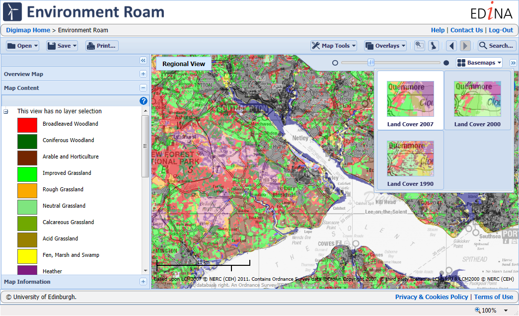
Following John was an informative and engaging presentation by Clare Rowland from the Centre for Ecology and Hydrology (CEH) who produce the Land-Cover Map datasets. Clare was heavily involved in the production of the latest version of the Land-Cover Map (LCM 2015) which is now available to view and print in Environment Roam and to download via Environment Download. Clare highlighted some interesting uses for the data including analysis of how land cover changes are affecting the numbers of bees.
The final presentation of the morning was a round up from EDINA’s Emma Diffley covering the achievements in the last 12 months and the plans for improvements to the service in the next 12 months. Of particular note were the introduction of two new collections: Aerial Digimap, launched in October 2016, and Lidar Digimap, launched in June 2017. The major work being undertaken by the team at the moment is a rewrite of all Roam clients to bring them up to date with the latest technology available, which will give them all a more modern look and feel whilst retaining all the existing functionality.
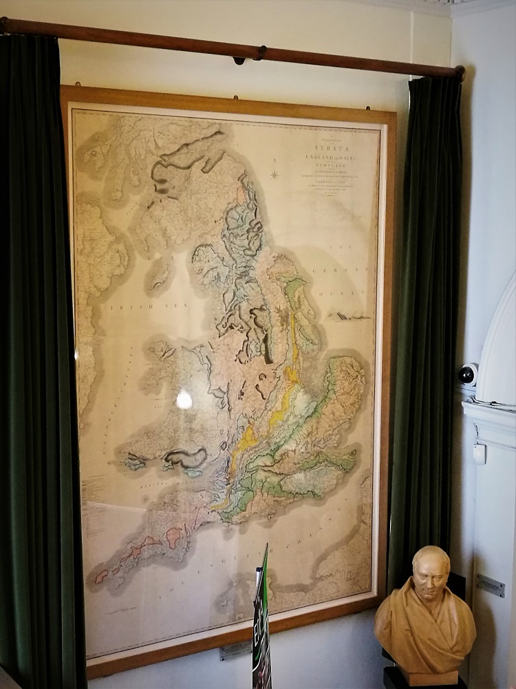
There was a great chance to network over lunch, when we also got to see William Smith’s pioneering Geological Map of Britain.
In the afternoon we held a feedback session where all the delegates had their chance to let us know how they feel Digimap is performing and what else they would like to see included in the service. This was then followed by a presentation and demonstration by EDINA’s Ian Holmes on how to use the Data from Digimap in various software packages to create 3D models. He showed us Ordnance Survey data GetMapping Aerial Imagery and some of the Environment Agency’s Lidar data in ArcGIS Pro, QGIS with the QGIS2Threejs plugin, and AutoDESK Infraworks.
The Presentations
John Murray: We have the Technology… We have the data… What next?
GeoForum included a workshop involving all participants on how EDINA runs the Digimap Service. We asked participants what they would like us to add or improve in terms of the data, service and support we provide.
Data
The main theme that came out of this discussion was that there is a great demand for overseas data, both global datasets and national data for other countries. Datasets such as OpenStreetMap and some of the global satellite data are now part of our long-term investment plans for Digimap.
There were also calls for Ordnance Survey’s AddressBase data. We have enquired about this particular dataset with Ordnance Survey before and the sticking point is the joint intellectual property rights with third party organisations. We will keep up the pressure and do our best to make this data available.
Service
The common theme running through most of the service enhancement requests was to be more joined up. Improvements would come by making maps, tools and data more interoperable between collections, improving the ability to analyse all the data that individual users are licensed to use. Other features highlighted come more under the banner of personalisation, allowing users to customise their experience more, or to share maps they have created with other Digimap users.
Support
There was broad consensus that the support we provide for Digimap is excellent, with the content and the broad range of support channels proving very useful. There was most appetite for more webinars and video tutorials which we are committed to expanding in the coming academic year. We also had requests for more marketing materials and detailed usage figures for Site Reps so that they could better support and promote Digimap.
Closing Remarks
Finally EDINA’s new director Janet Roberts closed the day with a strong message about improving the Digimap service for the academic community and the importance of feedback sessions to help guide this process. Janet also reiterated the University of Edinburgh’s commitment to the Digimap service and making further developments beyond the core offering to better meet the sector’s needs.
We feel that the day was a complete success and we learned a lot from the delegates, particularly in the feedback session. With the great presentations we know that the delegates got something from the day too. We see the feedback session as good start in a process whereby we can engage as many users of Digimap to help us continually improve the service specifically for Higher Education.
Environment Digimap has been in service for around 4 months now and already has 63 subscribing institutions, over 6000 active users and has made over 35,000 screen maps.
We’d really like to know what you think of the newest Digimap Collection and what you want to see added or improved. Once you have used the service then please go to the following web page and fill in the short survey, it will take less than 10 minutes and will help the future development of Environment Digimap:
If your institution doesn’t subscribe to Environment Digimap yet you still have 4 months where the service is completely free. The following blog post has information on how to subscribe:
For information on how previous Digimap surveys have affected the survey please have a look at the Quality Improvement reports on EDINA’s Benefits of Services page:
Digimap has become a teenager today, 10th January 2013. There have been some big changes to the service over the years, with interfaces coming and going and Ordnance Survey maps being joined by Historic (2005), Geology (2007), Marine (2009) and soon Environment (2013).
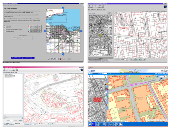
How Digimap Carto has changed since the service launched on the 10th of January 2000.
We’d really like to thank all our site reps and other institutional staff who have supported and promoted the service over the last 13 years.
Remember you can have your say about any of the Digimap Collections in the Impact Surveys available in the service and listed below. Please fill one in to let us know how we are doing and help us improve the service for the future:
Every year EDINA conducts a survey of its users to make sure that its services are meeting expectations and to find out what we should be doing to develop them further.
These surveys are very useful and have helped us prioritise the development of Digimap and our other geoservices. This year we redeveloped the Data Download facility and have begun the replacement of Carto because you told us they were areas you’d like to see improved. Other upcoming work prioritised by the surveys includes better print interfaces across all services and printable legends for Geology Roam.
As you can see it is beneficial for you to take part, so we’d really like you to let us know how we are doing. Please fill in a survey for each of the services you use; they can be found here:
Digimap Carto has been making maps for nearly 13 years now, though it last received a major facelift in 2006. Although it is still well used the underlying technology is no longer a viable platform to develop on. It has simply become too difficult to maintain in today’s environment of almost monthly changes to web browsers and the Java Runtime Environment.
Thankfully these advances in browser technology, and our underlying GIS and web mapping software, mean that we can now provide a Carto like service without the Java applet. In 2013 we will be launching a replacement for Carto that will run directly in an up-to-date web browser and still include advanced functionality. Until the new interface is launched we will keep Carto running, please go here if you are having trouble getting it to work: Carto Notes
With work starting on the new advanced mapping application we would really like to know which functions you value most in Carto. We’d also like to hear your ideas for any new features you would like to see available. We can’t promise to include everything, but knowing what you want helps us to make informed decisions.
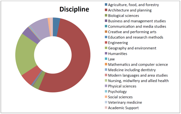
Digimap Ordnance Survey Collection Disciplines from the 2012 survey
These reports give an idea of who is using the services, what they are using them for and what their experience of using the site was like. There are a lot of interesting uses of the service quoted in the reports; it was very hard to pick the ones to include from the huge response that we had.
A final thank you to all those who filled in a survey.
Here are direct links to the reports about each geoservice provided by EDINA:
You may have noticed that the blog was pretty quiet in January and February. This has been due to an overwhelming response to the recent Digimap Surveys, and we’d like to thank everyone again who took the time to fill them in.
We have been busy creating the reports from the responses and making sure that the wealth of information you provided us is seen and recognised by our funding body, JISC. We have read so many stories about how important Digimap is to your studies, research and teaching and, as always, were very impressed by the new and innovative uses you have come up with.
We are particularly glad to see that Marine Digimap is being used for teaching and studying offshore alternative energy. This is set to be an important area of research and a growth industry in the UK so we are very pleased to see our service playing a part. Please get in touch with us if you would like your institution have trial access to Marine Digimap, or any of the other collections, to see how you can be using it to enhance your work.
We were also interested to see how widely Geology and Historic Digimap were being used by Architecture and Planning students to improve their site surveys. We knew that OS MasterMap was an important resource, but were not aware of the amount of detail that you were putting into your reports. Here are just a few more highlights of the uses you have for Digimap:
Analysing roost selection and foraging behaviour in bats.
Urban forestry ecosystem management.
4D-GIS techniques for spatio-temporal analysis of the Fylde Coast.
Mapping bumblebee distributions, salt marsh loss, wind farm locations, land use changes, the Roman Road network etc.
Research into accessibility of health services and environmental determinants of health.
Locating where an artist had made their pictures on the Pembroke coast.
At the same time as gathering information for JISC we also added in a few questions at the end of the survey about what you would like to see us concentrate on doing next. We got some very good feedback here and have recognised that there is a great demand for features such as printed maps and data to be provided in different formats. Over the coming months we will be using the survey’s findings to help us schedule improvements and additions to the service.
Once again, a huge thank you for filling in the survey, for the useful feedback and for the very kind comments about Digimap. It is great to know how important our work is to you.
You may have noticed that there are currently surveys running on all the Digimap services. These surveys are there to give you the opportunity to help us improve the service; we want your views to help shape the future of Digimap.
There is also another reason we are asking these questions; in the current economic climate, JISC will be shortly undertaking a detailed review of all the geo-services they fund including Digimap. It is very important that you have your say about any of these services that you use as your responses will contribute to this process.
We thank all of you who have responded to this survey; last year the results were fed back into the service and many of the comments were very valuable in helping us decide future directions. It is due to your feedback last time that we have included new features such as the Annotation Tools and prioritised redevelopment of the Data Download interface. Our aim is to do the same again this time and we have given more space to finding out what you want us to do next in the questions.
For those of you that are finding the survey an inconvenience we do apologise, however we hope you understand our reasons for making it as noticeable as possible. Due to good response rates for the Ordnance Survey Collection and Historic Digimap we now allow users to ignore the survey straight away. There is still a short time delay on the Marine and Geology services to make sure people take the time to read what we are asking them to do.

 This year’s GeoForum, held in the Geological Society of London on the 22nd of June, was a very successful event for all those who attended. Academics and support staff from subscribing institutions got to meet representatives from the Digimap team and experts from our data suppliers and the wider geospatial community.