Any views expressed within media held on this service are those of the contributors, should not be taken as approved or endorsed by the University, and do not necessarily reflect the views of the University in respect of any particular issue.
Digimap is an online map and data delivery service, available by subscription to UK Higher and Further Education establishments. Operated by EDINA at the University of Edinburgh, Digimap offers a number of data collections, including Ordnance Survey, historical, geological, aerial photography, LiDAR, marine maps, land cover mapping, global mapping and census data. For more information about Digimap go to our website: https://digimap.edina.ac.uk Background image Contains OS data (c) Crown Copyright and database right 2022
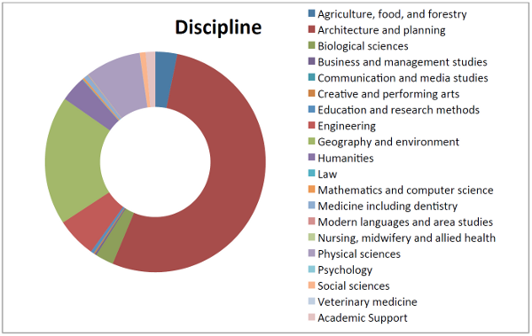
Digimap Ordnance Survey Collection Disciplines from the 2012 survey
These reports give an idea of who is using the services, what they are using them for and what their experience of using the site was like. There are a lot of interesting uses of the service quoted in the reports; it was very hard to pick the ones to include from the huge response that we had.
A final thank you to all those who filled in a survey.
Here are direct links to the reports about each geoservice provided by EDINA:
You may have noticed that the blog was pretty quiet in January and February. This has been due to an overwhelming response to the recent Digimap Surveys, and we’d like to thank everyone again who took the time to fill them in.
We have been busy creating the reports from the responses and making sure that the wealth of information you provided us is seen and recognised by our funding body, JISC. We have read so many stories about how important Digimap is to your studies, research and teaching and, as always, were very impressed by the new and innovative uses you have come up with.
We are particularly glad to see that Marine Digimap is being used for teaching and studying offshore alternative energy. This is set to be an important area of research and a growth industry in the UK so we are very pleased to see our service playing a part. Please get in touch with us if you would like your institution have trial access to Marine Digimap, or any of the other collections, to see how you can be using it to enhance your work.
We were also interested to see how widely Geology and Historic Digimap were being used by Architecture and Planning students to improve their site surveys. We knew that OS MasterMap was an important resource, but were not aware of the amount of detail that you were putting into your reports. Here are just a few more highlights of the uses you have for Digimap:
Analysing roost selection and foraging behaviour in bats.
Urban forestry ecosystem management.
4D-GIS techniques for spatio-temporal analysis of the Fylde Coast.
Mapping bumblebee distributions, salt marsh loss, wind farm locations, land use changes, the Roman Road network etc.
Research into accessibility of health services and environmental determinants of health.
Locating where an artist had made their pictures on the Pembroke coast.
At the same time as gathering information for JISC we also added in a few questions at the end of the survey about what you would like to see us concentrate on doing next. We got some very good feedback here and have recognised that there is a great demand for features such as printed maps and data to be provided in different formats. Over the coming months we will be using the survey’s findings to help us schedule improvements and additions to the service.
Once again, a huge thank you for filling in the survey, for the useful feedback and for the very kind comments about Digimap. It is great to know how important our work is to you.
You may have noticed that there are currently surveys running on all the Digimap services. These surveys are there to give you the opportunity to help us improve the service; we want your views to help shape the future of Digimap.
There is also another reason we are asking these questions; in the current economic climate, JISC will be shortly undertaking a detailed review of all the geo-services they fund including Digimap. It is very important that you have your say about any of these services that you use as your responses will contribute to this process.
We thank all of you who have responded to this survey; last year the results were fed back into the service and many of the comments were very valuable in helping us decide future directions. It is due to your feedback last time that we have included new features such as the Annotation Tools and prioritised redevelopment of the Data Download interface. Our aim is to do the same again this time and we have given more space to finding out what you want us to do next in the questions.
For those of you that are finding the survey an inconvenience we do apologise, however we hope you understand our reasons for making it as noticeable as possible. Due to good response rates for the Ordnance Survey Collection and Historic Digimap we now allow users to ignore the survey straight away. There is still a short time delay on the Marine and Geology services to make sure people take the time to read what we are asking them to do.
Here at EDINA we are constantly evaluating our services and really value user feedback. Our funders are also keen to know what impact the services have. We are currently assessing how satisfied our users are with the Digimap Collections so we can gauge how well we are doing. Please could you fill in a quick user satisfaction survey for each of the Digimap Collections you use; you can pass on the links to anyone else you know who uses Digimap.
The survey is very short with only 5 questions after you have put in some details about yourself. All data collected will be held anonymously and securely. No cookies are used in the completion of the survey.
EDINA is undertaking a survey to understand more about support for online geospatial resources, spatial data, GIS and related software. We would like to learn more about what support and training is currently available, what is useful and what might be provided to improve the support available.
If you have any kind of support role with respect to spatial data, GIS, CAD or geospatial resources we would be grateful if you would complete the following survey and would pass it on to others who are also involved in supporting users of all things geospatial.
The survey will remain open and available until TUESDAY 23 JUNE 2009.
This is NOT a service-specific survey, so anyone involved in supporting users of geospatial data and resources has something valuable to contribute. Please pass it on. Gathering feedback is a challenging task, so your efforts to complete these questions is very much appreciated.
The survey should take around 20 minutes to complete and the majority of questions are multiple choice checkboxes. There will be a prize draw for four £25 Amazon vouchers. Please enter your name and email address at the end of the survey if you wish to be entered into the draw.