Any views expressed within media held on this service are those of the contributors, should not be taken as approved or endorsed by the University, and do not necessarily reflect the views of the University in respect of any particular issue.
Digimap is an online map and data delivery service, available by subscription to UK Higher and Further Education establishments. Operated by EDINA at the University of Edinburgh, Digimap offers a number of data collections, including Ordnance Survey, historical, geological, aerial photography, LiDAR, marine maps, land cover mapping, global mapping and census data. For more information about Digimap go to our website: https://digimap.edina.ac.uk Background image Contains OS data (c) Crown Copyright and database right 2022
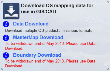
Both MasterMap Download and Boundary Download have been withdrawn today 28th May 2013.
The functionality and datasets offered by MasterMap Download and Boundary Download are now available through the standard Data Download application. This can be found in the Download OS mapping data section of Digimap’s Ordnance Survey Collection.
Please let us know if you have any questions or concerns about this or anything else:
All Digimap services will be unavailable for at least 2 hours on Saturday 26th of January for some essential hardware maintenance. The service should also be considered ‘at risk’ for the rest of the weekend. We apologise for any inconvenience caused.
In January 2013 the OS MasterMap®, Boundary-Line™ and Code-Point® data products will be available from the Data Download service. We have tried to keep the changes necessary to accommodate these products to a minimum as the current interface has proved so successful (190,000 map tiles and files downloaded Nov 2012).
Here is a list of the changes and additions you will see in the interface; please note that they may still be subject to some change prior to launch.
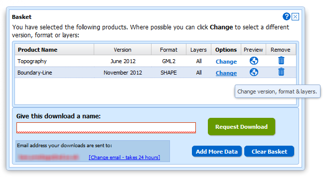
Both Boundary-Line and MasterMap have layers so we have had to make changes to the basket:
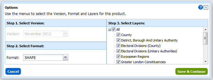
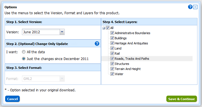
Instead of selecting Version and Format using drop-down menus there is a new pop-up for changing both these and the layers for each of the products in your basket. You can access this pop-up by clicking on the Change link in the Options column:
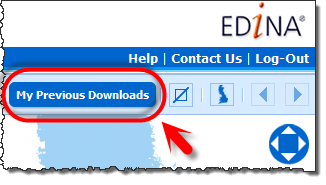
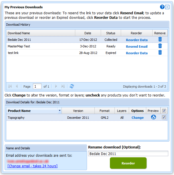
We have also improved the “My Account” section which is now called “My Previous Downloads”:
Once in the interface you can access any of your past downloads and reopen them at the basket stage:
It is now much easier to update your previous downloads to the latest version, get the same data in a different format or simply reorder data you have previously taken. In addition to these functions we have incorporated the ability to make Change-Only-Updates (COUs) to MasterMap Data:
Both Boundary Download and MasterMap Download will be kept in service for a transition period but as there are so many benefits to using Data Download we hope everyone will make the switch quickly. We expect to have switched off these services by the end of April.
Digimap Carto has been making maps for nearly 13 years now, though it last received a major facelift in 2006. Although it is still well used the underlying technology is no longer a viable platform to develop on. It has simply become too difficult to maintain in today’s environment of almost monthly changes to web browsers and the Java Runtime Environment.
Thankfully these advances in browser technology, and our underlying GIS and web mapping software, mean that we can now provide a Carto like service without the Java applet. In 2013 we will be launching a replacement for Carto that will run directly in an up-to-date web browser and still include advanced functionality. Until the new interface is launched we will keep Carto running, please go here if you are having trouble getting it to work: Carto Notes
With work starting on the new advanced mapping application we would really like to know which functions you value most in Carto. We’d also like to hear your ideas for any new features you would like to see available. We can’t promise to include everything, but knowing what you want helps us to make informed decisions.
If you use Mozilla’s Firefox as your browser then you may not be able to access Digimap’s Carto application. The reason for this is that Mozilla is now (from the 30th August 2012) automatically blocking Java. The reason that Mozilla has taken this stance is that a Java exploit has been added to the notorious Blackhole exploit toolkit. In simple terms, running Java applications through your browser opens your machine up to hackers, and we dont want that.
We are working on Carto’s successor which we hope to launch in 2013 and this will not rely on Java. If you need to use Carto, then it will still work in Internet Explorer and Chrome browsers. Hopefully Java will patch the breach soon and it will work again in Firefox.
For more information about this security issue please read this.
Due the success of the New Data Download we are announcing the retirement of our old Data Download and Gazetteer Download facilities. The new Data Download performs all the functions of the two older ones, which have now been around for many years.
Were not stopping there though as the new Data Download is continuing to be developed and we hope to have a few enhancements added in June. In addition to this the data from Boundary Download will be brought in later this year and eventually MasterMap data will be included. This will allow you to get all the Ordnance Survey Data offered by Digimap from one single facility.
Please note that the Gazetteer Query and Gazetteer Plus services will not be affected.
If you have any comments or suggestions about the new Data Download facility or any other part of the Digimap service then please let us know: edina@ed.ac.uk
As lots of people are currently working on projects and dissertations we thought we’d share a few tips on using the OS MasterMap data from Digimap.
NOTE: MasterMap Download will be temporarily unavailable as part of the ‘At Risk’ period on Monday the 22nd of August. It will also be unavailable for about an hour on either Wednesday 24th or Thursday the 25th of August as well. This is to allow for some essential hardware maintenance on the server that houses the Database. We are really sorry for any inconvenience this causes.
The MasterMap data available will be updated as part of our annual data refresh at the beginning of September. If you need the 2010-2011s data then please order in advance of Monday the 22nd to ensure you don’t get caught up with the maintenance.
Downloading the Data
Remember that if you just want MasterMap as a background map you can use the 1:1000 or 1:2000 Raster versions of the data. This is available from the Data Download facility:
Once you have downloaded your MasterMap Data you will most likely need to convert it into a format that your GIS can use. There are three main options to do this, InterpOSe, OSM2MIF and Productivity Suite, see the following link for more information:
Due to this work there will be some short Disruptions to all the services between 17:30 and 18:30. We hope you find the new features useful, please let us know if you have any feedback:
The Digimap services will be no longer be ‘at risk’ on Thursday the 9th of June. The software updates are now being rescheduled for another date, we will inform you once we know when this will be.
Once again we apologise for any inconvenience caused.
All Digimap services will be ‘at risk’ from 8:00 a.m. on Thursday the 9th of June. Our servers are undergoing some software updates so there will be some brief interruptions to the service while we switch over to our back up computers. Later in the day the will again be brief interruptions when we switch back to the main servers. If you find that your Digimap session is interrupted please wait for 15 minutes and then login again; though you may find access to certain facilities takes a little longer to be reinstated.
We apologise in advance for any inconvenience this may cause.