Any views expressed within media held on this service are those of the contributors, should not be taken as approved or endorsed by the University, and do not necessarily reflect the views of the University in respect of any particular issue.
Digimap is an online map and data delivery service, available by subscription to UK Higher and Further Education establishments. Operated by EDINA at the University of Edinburgh, Digimap offers a number of data collections, including Ordnance Survey, historical, geological, aerial photography, LiDAR, marine maps, land cover mapping, global mapping and census data. For more information about Digimap go to our website: https://digimap.edina.ac.uk Background image Contains OS data (c) Crown Copyright and database right 2022
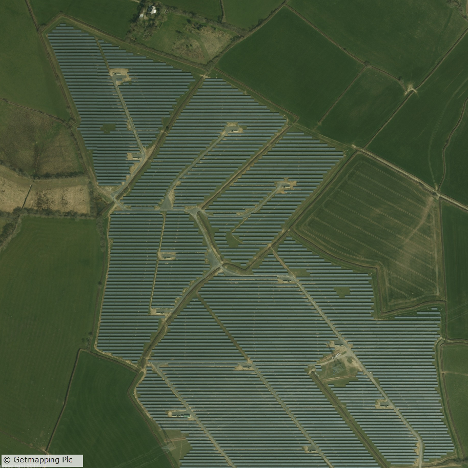
Canworthy Solar Farm, which became operational in 2014 and covers approximately 55 hectares (~67 football fields)
Aerial Digimap updates
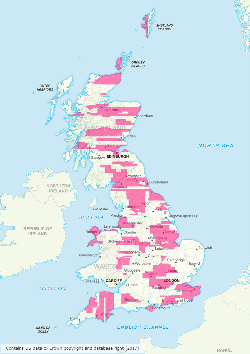
March/April 2017 has been a busy couple of months for the Data Team who have been working hard to process a huge area of updated aerial imagery data from the data supplier, Getmapping. The update consists of around 80,000 individual 1km tiles, all captured in 2015, which is approximately 30% of the country.
Prior to the update just over 50% of the data was from 2013 or later; after the update 77% of the data is from 2013 or later.
This means that more up to date imagery is now available for viewing and download through Aerial Digimap for a significant proportion of the country.
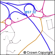
The map below shows the approximate distribution of the updated data.
Click on map to view larger version
This is the first update we have received from Getmapping, but we are expecting another update later this year containing imagery captured in 2016.
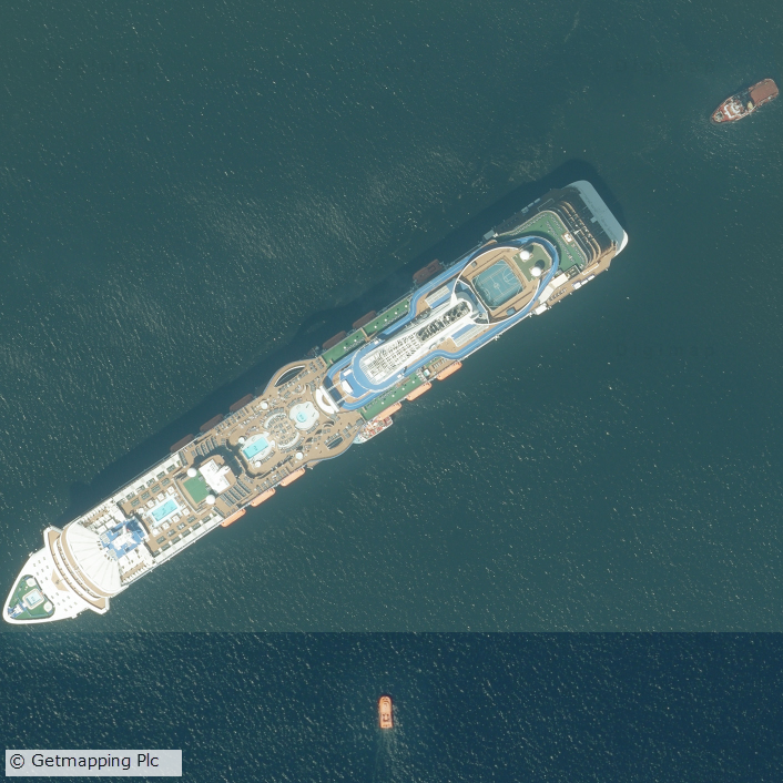
Cruise liner in the Firth of Forth
We will add this to the service as quickly as we can to ensure that the most up to date data is always available to Aerial Digimap users. In order to make it clear where the data has been updated, we will add an Availability/Reference Grid to Aerial Download so that users can easily identify if the imagery has been updated in their study area(s). This grid will be added to the system in the next couple of weeks.
We are still investigating the best way to make previous versions of the data available, but in the mean time only the most recent data is available through Aerial Roam and Aerial Download.
Webinar resources
We recently ran a webinar highlighting the data and showcasing a number of potential uses for the imagery. The webinar was recorded in full and is available on our YouTube channel. The slides used during the webinar and a transcript of all questions and answers are available on our help page.
3D model using Aerial Imagery, OS Terrain 5 DTM and MasterMap Building Height Attribute
Data information
The aerial imagery data in the service is 25cm resolution vertical aerial orthophotography supplied by Getmapping PLC, and is the most detailed aerial imagery available for the whole of Great Britain. As well as being a really interesting dataset the imagery also has a number of practical uses across a wide range of disciplines from urban planning and 3D modelling to land use and archaeological studies.
Subscribing
To see if your institution already subscribes to Aerial Digimap, please see our subscribing institutions help page. Information on how to subscribe to the new service is available on the Aerial Digimap Subscription page.
If you have any questions about the service please consult the dedicated Aerial Digimap help pages or contact the Digimap support team using the details below.
Dataset updates in Ordnance Survey Digimap
OS Data Download:
Product Name
OS Publication Date
Code-Point
February 2017
1:25,000 Colour Raster
March 2017
1:50,000 Colour Raster
March 2017
Points of Interest
March 2017
OS Roam:
Product Name
OS Publication Date
1:25,000 Colour Raster
March 2017
The OS data update page is kept up to date with all dataset updates in the collections.
If you have any questions about the dataset updates or Digimap please contact us:
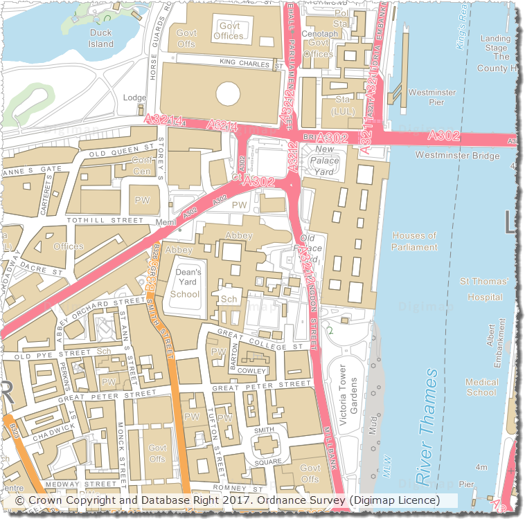
We have updated a number of key datasets in Jan/Feb 2017 in the Ordnance Survey collection of Digimap. These updates bring the datasets available from Digimap inline with the latest versions published by Ordnance Survey. Of particular note are the updates to the two most detailed mapping products available from Ordnance Survey: OS MasterMap Topography Layer and OS VectorMap Local.
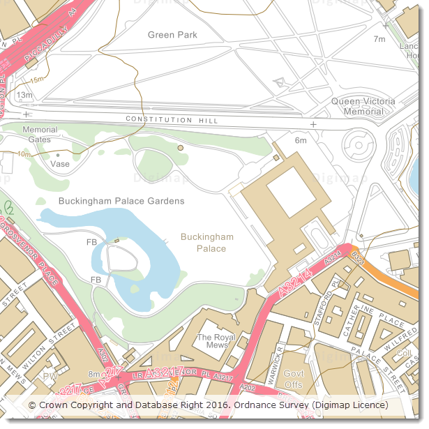
OS VectorMap Local showing WestminsterOS MasterMap Topography Layer showing Westminster
OS Data Download:
Product Name
OS Publication Date
Integrated Transport Network (ITN) Layer
December 2016
OS MasterMap Topography Layer
December 2016
OS MasterMap Water Network Layer
January 2017
OS VectorMap Local
January 2017
OS VectorMap Local Raster
January 2017
MiniScale
January 2017
OS Terrain 5 Contours
January 2017
OS Terrain 5 DTM
January 2017
OS Open Names
January 2017
Code-Point with polygons
January 2017
Code-Point Open
February 2017
OS Roam:
Product Name
OS Publication Date
OS MasterMap Topography Layer
December 2016
OS VectorMap Local
Jan 2017
OS VectorMap Local Raster
Jan 2017
MiniScale
January 2017
The OS data update page is kept up to date with all dataset updates in the collections.
If you have any questions about the dataset updates or Digimap please contact us:
OS Open Map – Local (OML) was recently added to the Digimap Roam application, giving users the ability to create maps online with a detailed, vector open dataset. OML is the most detailed vector mapping product available from Ordnance Survey as Open Data. We have added this dataset to the following map views in Digimap Roam:
Map View
Default Print Scale
Neighbourhood View
1:10,000
Street View
1:5,000
Detailed View
1:2,500
The dataset is rich in features and includes detailed building outlines and Car Charging Points, which are sourced from the National Charge Registry.
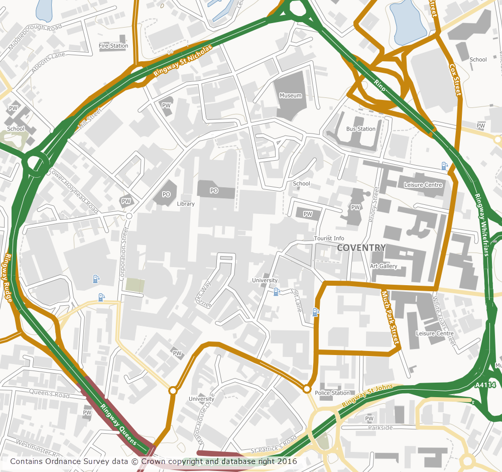
OS Open Map – Local showing Coventry City Centre
Ordnance Survey first released OML as a beta product in March 2015 and Digimap users have been able to download this dataset via the Data Download application since April 2015. The October 2016 release of OML marks the end of the beta period and provides the first main version of the dataset.
OML is intended to be used as a detailed basemap on which to visualise your own data and is designed to be an alternative to OS Street View, which will be withdrawn in March 2017 by Ordnance Survey.
The cartography team at Digimap have worked hard to implement a consistent style with that of the smaller scale VectorMap District product, ensuring a familiar look and feel between the two Open Data products. Contours from the OS Terrain 50 product are included when viewing the data in Roam, to give greater context especially in rural and hilly areas.
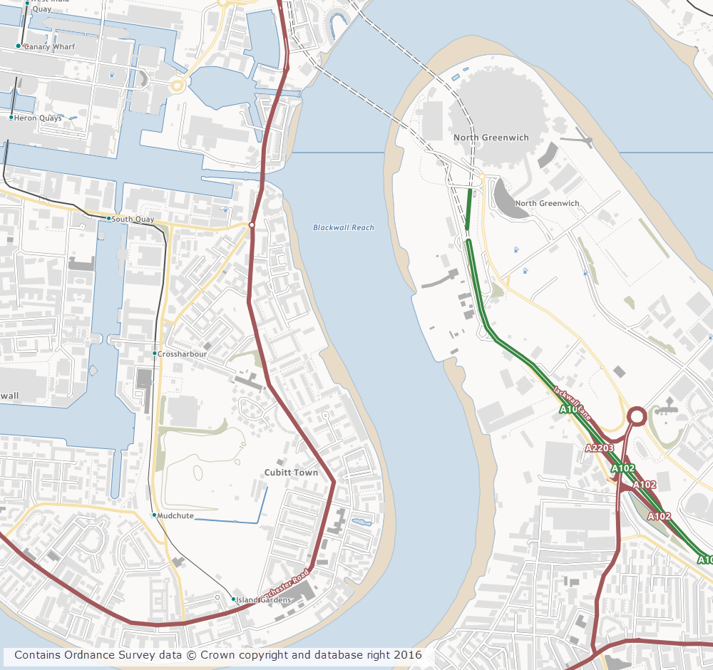
OS Open Map – Local showing Canary Wharf
Further information on the new dataset can be found on the Digimap help page or the Ordnance Survey website. We hope you like the new data, if you have any questions about the dataset or Digimap please contact us:
A number of datasets in the Ordnance Survey Collection have been updated in May this year. We’ve also made a number of improvements to some of the datasets that are popular for 3D modelling which will hopefully make it easier to use these datasets in CAD applications. The main changes are:
OS MasterMap Sites Layer now available in DWG and ESRI Shapefile format (previously it was only available in GML)
OS Terrain 5 DTM is now available in XYZ format for use in CAD applications
OS Terrain 5 Contours in DWG format are now provided as as 3D contours with the height of each feature set to the correct contour height
The data format help page has been updated to reflect these changes and is a good place to go if you are interested to see which datasets are available in a specific format.
The dataset updates are detailed in the tables below for OS Data Download and OS Roam:
OS Data Download:
Product Name
OS Publication Date
Boundary Line
May 2016
* OS Locator
May 2016
OS Terrain 5 Contours
April 2016
OS Terrain 5 DTM
April 2016
OS VectorMap Local Raster
April 2016
OS VectorMap Local
April 2016
OS Open Roads
May 2016
Code-Point Open
May 2016
* Note: this is the last update to OS Locator that will be supplied by Ordnance Survey who have announced that they are retiring this product. Users are advised to use OS Open Names instead. Whilst the data will still be available to download through Digimap, these products will no longer be updated to reflect changes in the real world.
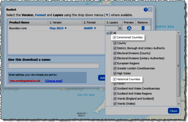
The latest version of Ordnance Survey’s Boundary-Line data contains two new layers, Ceremonial Counties and Historical Counties.
Ceremonial Counties
This new layer in the Boundary-Line data represents the areas of England, Scotland and Wales that are represented by a Lord Lieutenant. The Lord Lieutenant is the chief officer of the county and representative of the Crown; whenever the Queen visits an area she will be accompanied by the Lord Lieutenant.
This layer is very useful for those who want to make a map of Great Britain divided into its counties without all the complexities of Unitary Authorities, Districts and Boroughs. This is the layer to choose when making a map showing a more traditional view of Great Britain without making a historical view.
Historical Counties
The historic counties dataset shows the county boundaries in place in 1888 in England and Wales and 1899 in Scotland. The boundaries for England and Wales were derived from mapping from the National Archives dating from 1890. The Scottish boundaries are derived from maps as late as 1940.
This layer is very useful for those studying this time period and when combined with the ceremonial counties and modern the most up to date boundaries gives a good picture of how fluid the boundaries are over time.
Selecting Layers in Data Download
If you have the Boundary-Line data you need already but would like to add the new layers without downloading it all again then follow this useful tip. Once you have added the product to your basket click on the arrow in the layers column to pick and choose those that you want to take. See the image below:
You will then just receive these new layers and not all the others which you may already have or not need.
Please let us know if you have any questions about this or any other aspect of the service:
Ordnance Survey’s most detailed open data product, Open Map – Local, is now available to download from the Digimap service along with the OS Open Names gazetteer, OS Open Rivers water network and OS Open Roads road network. There are no restrictions on what the data can be used for, it just needs to carry a simple copyright acknowledgement:
This is a vector dataset best viewed at a scale of 1:10,000, with layers including buildings, roads, sites, railways, hydrology, coastline, woodland and cartographic text. The data comes in Shapefile format for easy access in the most commonly used GIS software.
The data isn’t quite as feature rich as the licensed VectorMap Local data, though it does contain some nice additions such as the ability to highlight public buildings and their grounds.
OS Open Names
This is a gazetteer with 2.5 million entries, made up of over 870,000 named and numbered roads, nearly 44,000 settlements and over 1.6 million postcodes. This dataset is billed as the comprehensive list of Great Britain’s place names, road names and numbers and postcodes, and is certainly the most detailed gazetteer in Digimap. The data is available in CSV or GML formats.
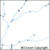
OS Open Rivers
This is a generalised network view of the rivers of Great Britain. The data is designed to give its users a high-level view of where the water flows across the land surface. Though it doesn’t show the detail of the actual width or shape of the river as the topographic data it is a proper network. This means it doesn’t get interrupted by bridges or other features that prevent the topographic data from being used to “route” water through the river network. The data is available in Shapefile and GML formats.
OS Open Roads
Like OS Open Rivers this is a generalised network of roads. Topographic data will provide more detail about the road dimensions and real world position, however this data provides an uninterrupted network for road routing analysis. The data is available in Shapefile and GML formats.
Geoforum aims to bring together staff who support the use of Digimap and other geoservices from subscribing institutions around the country and showcase what’s new and upcoming from EDINA. It also gives people an opportunity to ask the Digimap team questions and to chat with others about how support and promote geoservices.
There was a live blog running throughout the day which is still available for you to read and find out what happened.
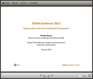
Keynote Address
The keynote was delivered by Shelley Mosco of The University of Greenwich and was titled: Digimap Data and a non-traditionalist approach. Shelley is a member of the The School of Architecture, Design and Construction and described the ways in which spatial data could be used to inform design. Shelley was keen to stress the importance of spatial data and GIS in the implementation of Building Information Models (BIMs). BIMs have been used in large engineering projects for some time, however the government is making them mandatory for all publicly funded building projects in England and Wales. This means that commercial organisations will be looking for students to have been trained in the concept of BIMs and the software that drives them. You can find out more about BIMs through the following links:
BIM Task Group – government site promoting best practise for BIM
COBie – Construction Operations Building Information Exchange
Two of Shelley’s current MSc students also gave brief overviews of their experiences of learning about GIS and using spatial data in their projects. Both David Parfitt and Robert Park were self-confessed GIS newbies, but they managed to get data from Digimap and use it in their conservation projects. The data allowed them to visualise and analyse the environment and provide evidence to support their proposed designs. Their demo’s were excellent a they really showed the power of simple GIS analysis.
You can view the slides from this presentation here:
After the Keynote was a presentation that focused on Open or “Free” resources for geospatial teaching and research. The presentation looked at software, web-mapping and data. The main resources are listed below:
Data
OS Open data is available through the Digimap Data Download service.
ShareGeo Open is a repository for open geospatial data. It has lots of useful and interesting datasets on a variety of subjects such as wind farms, crime, boundaries and DTMs
QGIS – one of the best open source GIS out there. Lots of functionality and plugins that allow you to perform complex spatial analysis. It is also well supported by forums.
GRASS – a remote sensing package aimed at serious remote sensor’s. If you are a newbie to remote sensing, you can access GRASS tool through the GRASS plugin for QGIS which makes things really simple.
Web-mapping
Digimap is a great web mapping tool, but how can you create your own interactive web map for your website?
MapBox – simple intuitive web site that helps users build interactive web maps. Basic functionality is free, more advanced functions are available for a small fee.
Leaflet – the engine behind MapBox, it is free but requires user to do a “bit” of programing
Openlayers – an alternative to Leaflet which is more flexible. Openlayers powers Digimap. Requires a fair amount of programming knowledge.
MapServer – implements Openlayers for enterprise scale operations. MapServer is also used for Digimap services.
You can view the slides from this presentation on slideshare here:
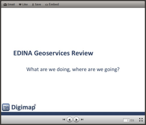
After lunch the lead of EDINA’s geoservices Support team, Emma Diffley, shared what we have been busy working on.
Interfaces
Digimap is being streamlined, each collection will eventually have just a Roam and a Download. These interfaces will all look and work in a very similar way. The aim is to make the service more consistent and easier to use, but also much easier to maintain.
EDINA will be withdrawing Digimap Carto on 31st July 2013. Carto, launched in 1996, is harder and harder to maintain, so we have taken the best bits and put them into Roam.
On top of the Carto functionality already added to Roam the following improvements are coming soon:
an improved way of saving and opening maps and annotations
a Basemaps button to change the style or even mapping product you are viewing at each scale
The Download interfaces will also going through a similar process.
Data
A single consistent style for all the vector products through all the scale levels accessible through using the basemaps button in the new Roam.
VectorMap Local (VML) in shapefile and DWG formats
ArcGIS layer files for symbolising VML shapefiles coming soon
OS MasterMap Topo available as DWG is being planned
Support
There is a new Resource Centre, which does not require login, with answers to questions, videos, case studies etc.
Beyond Digimap
GoGeo has added more resources and now highlights the “Editor’s Picks”
ShareGeoOpen now has over 210 resources all of which are open and free to use
FieldTrip GB is a mobile app for capturing data, see below
GeoTagger – a tool to allow you to edit the metadata for your photos
Cartogrammar – upload your data and visualise it in different ways
UKBORDERS is now the UK Data Service Census Support Unit
On the horizon
We are still awaiting news on funding, but are lots of things we would like to do. Currently our focus is to “mobilise” more services and we will be continuing to add new support materials once the latest round of Roam and Download changes have been made.
If there are things you would like us to do we really want to hear about them. Recommendations from the user community carry real weight for us, and we are keen to hear ideas on new data or services we should be providing.
You can view the slides from this presentation here:
The final part of the day was about EDINA’s new mobile app for carrying out field work Fieldtrip GB. It simplifies the process of capturing data in the field against quality cartographic mapping. It is equally at home in urban environments as it is in rural ones. Custom forms allow users to design their own data capture projects and collect exactly what they need for their research. The session gave a brief overview before running a “live” group data collection exercise. A custom form was created and deployed to participants mobile phones. They then headed outside and captured data on things like building fabric and design. After 15 mins everyone reconvened and the collected data was “synced” and exported to Google Earth.
You can view the slides from this presentation on slideshare here:
As mentioned earlier, there is a transcript of the whole day in the form of a live blog so if you didn’t manage to attend and want to find out what happened please have a look.
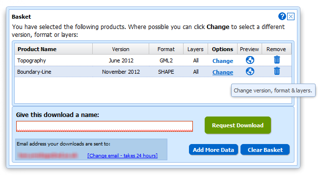
In January 2013 the OS MasterMap®, Boundary-Line™ and Code-Point® data products will be available from the Data Download service. We have tried to keep the changes necessary to accommodate these products to a minimum as the current interface has proved so successful (190,000 map tiles and files downloaded Nov 2012).
Here is a list of the changes and additions you will see in the interface; please note that they may still be subject to some change prior to launch.
Both Boundary-Line and MasterMap have layers so we have had to make changes to the basket:
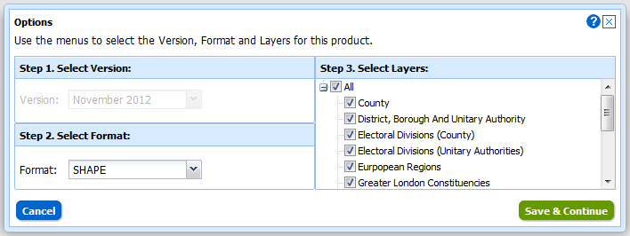
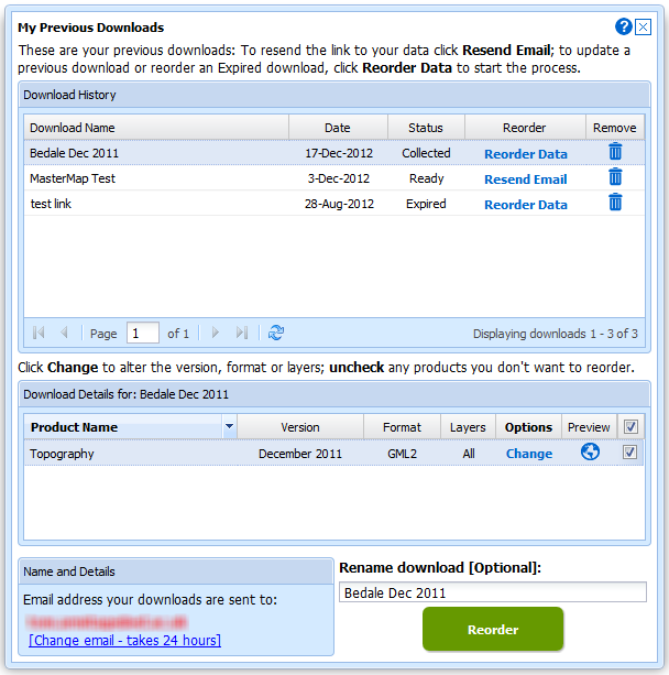
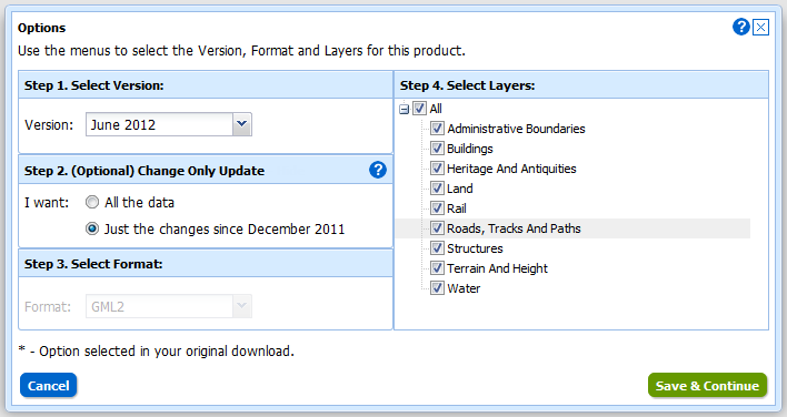
Instead of selecting Version and Format using drop-down menus there is a new pop-up for changing both these and the layers for each of the products in your basket. You can access this pop-up by clicking on the Change link in the Options column:
We have also improved the “My Account” section which is now called “My Previous Downloads”:
Once in the interface you can access any of your past downloads and reopen them at the basket stage:
It is now much easier to update your previous downloads to the latest version, get the same data in a different format or simply reorder data you have previously taken. In addition to these functions we have incorporated the ability to make Change-Only-Updates (COUs) to MasterMap Data:
Both Boundary Download and MasterMap Download will be kept in service for a transition period but as there are so many benefits to using Data Download we hope everyone will make the switch quickly. We expect to have switched off these services by the end of April.
Digimap OpenStream, EDINA’s open WMS service, has been updated with the latest version of OS Street View from the OS OpenData collection. The latest version is from May 2011 and contains change-only updates.
EDINA aims to provide the latest version of OS OpenData via the OpenStream service. This means that datasets may be updated part way through an academic year.
For more information about OpenStream and to register click on the following link:


 EDINA’s Geoforum 2013 was a great success with over 50 academic and support staff attending four very well received presentations: