WMS functionality added to Digimap Roam

We are very pleased to announce that we we recently added WMS (Web Map Service) functionality to all Digimap Roam applications. This new facility allows you to pull in map data from a whole host of publicly accessible services allowing you to visualise a wealth of data in the familiar Digimap Roam interface. This is beta functionality, and there are a few areas that need further improvement but we were keen to get it out there as quickly as possible so that you could start making use of it. Whilst we continue to work on the functionality, we welcome any feedback you may have. Our contact details can be found at the bottom of this post.

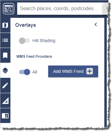
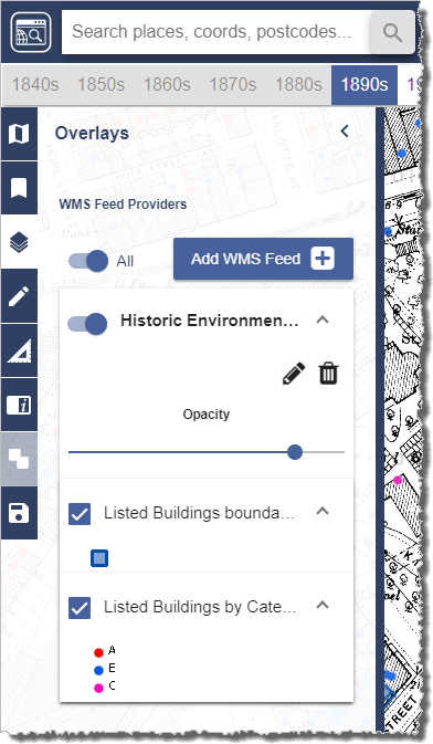
The WMS functionality can be found in the Overlays menu panel on the left hand side:

WMS functionality

To add a WMS feed to your map you need to press the Add WMS Feed button, which will bring up the following window:

Add WMS Feed popup

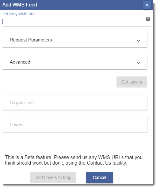
You will need to paste the getCapabilities URL in to the ‘3rd Party WMS URL’ field at the top of the popup. This URL is usually in the following format, but may be different depending on the service:

https://[servername]/service?SERVICE=WMS&Version=1.1.1&REQUEST=getCapabilities

Having entered the URL the Get Layers button should become active, press this to retrieve all the layers available via the entered WMS URL. Finally add the layers to your map using the Add Layers to Map button to add them to your current map window. You can then control the opacity of each layer using the appropriate opacity slider and the order they are displayed by clicking and dragging. It’s possible to edit the names displayed e.g. to choose shorter names that are easier to see by pressing the edit button next to each entry:

WMS overlay panel controls

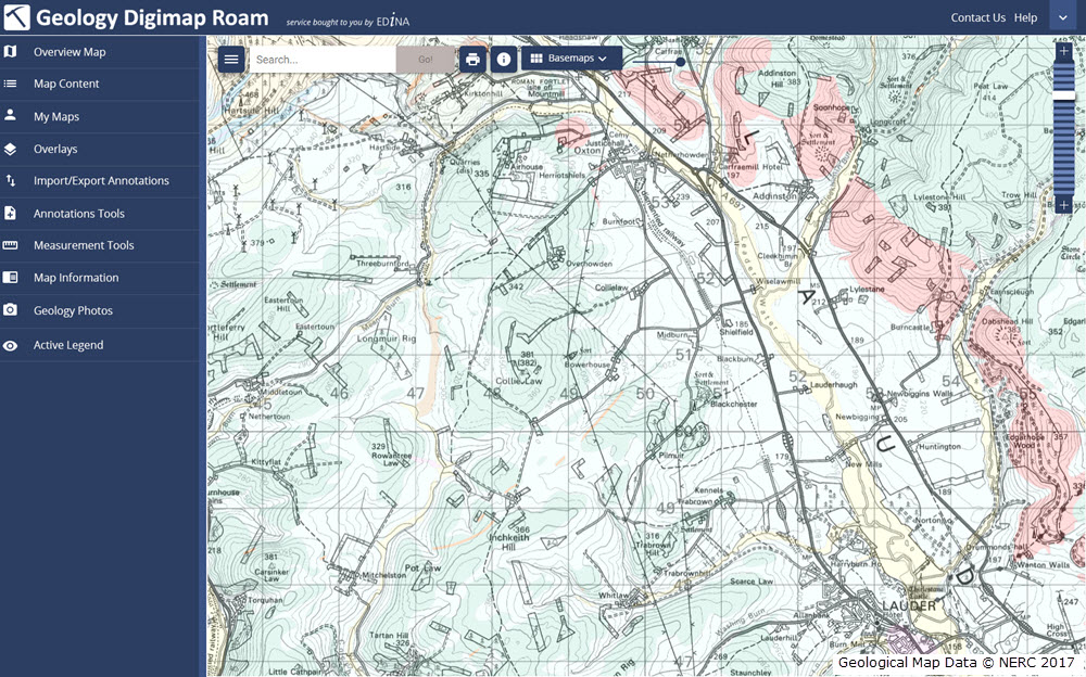
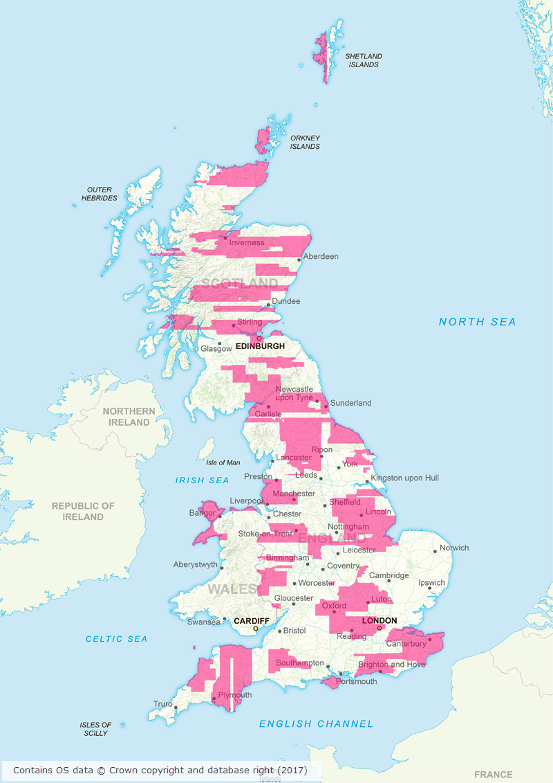
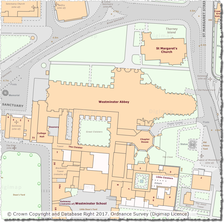
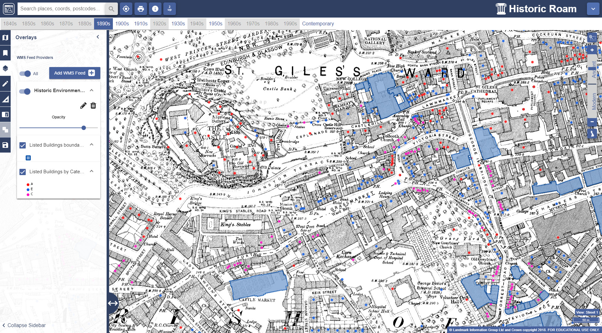
There are numerous WMS available for the UK, many of which are listed on data.gov.uk. The image below shows listed buildings (boundaries and category) published by Historic Environment Scotland on top of the 1st Edition 1:2500 County Series map published in 1896 in Ancient Roam:

Listed buildings pulled via WMS on top of historic map from 1896 in Historic Roam

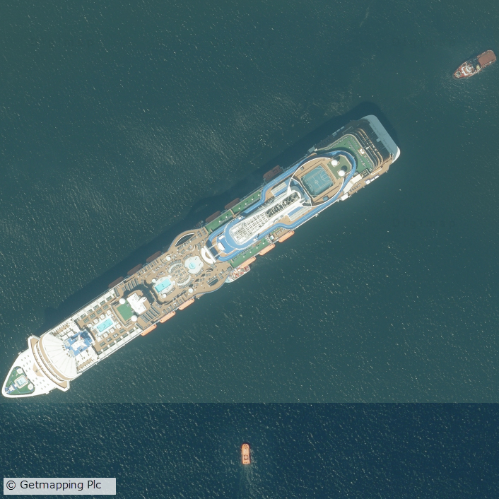
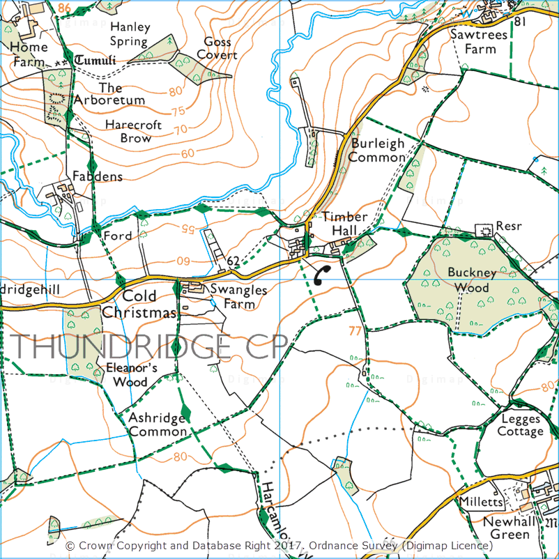
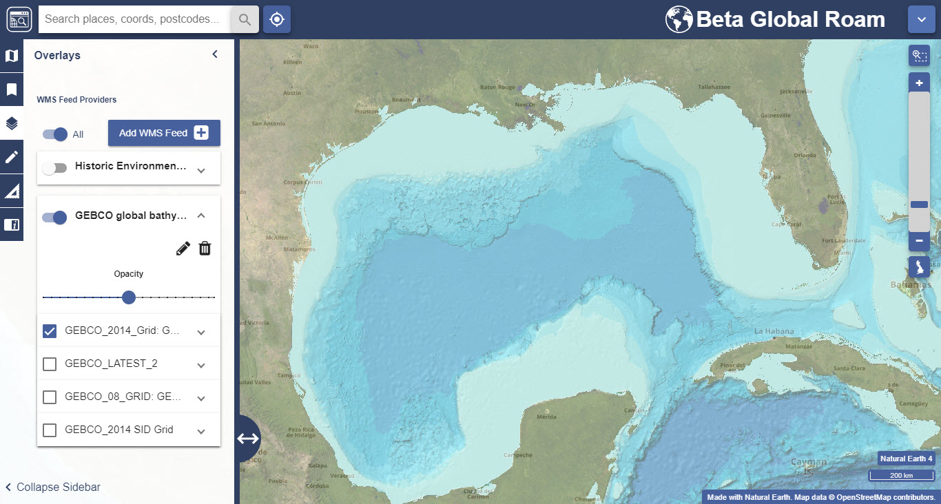
There are also lots of WMS available that serve up global data and can be viewed using the latest Global Digimap collection.  One example of this is the General Bathymetric Chart of the Oceans (GEBCO), shown below in Global Roam centred on the Gulf of Mexico:

Bathymetric data via WMS on top of OpenStreetMap data in Global Roam

We have put together a help page which lists examples of a variety of WMS from different sources. Whilst we can’t guarantee that they will all work all of the time if you do come across a WMS that you think should work and have tested that it works in other software, such as QGIS or ArcGIS Online, please let us know so we can improve the service.

Known issues

As mentioned above, this is new beta functionality and as such there are a number of known issues and things to bear in mind:

  • Currently no warning messages are displayed if a WMS fails to load. If the data has not appeared after a reasonable period of time please try to access the data via the same URL in QGIS or ArcGIS Online. If the data does load in QGIS or ArcGIS Online please send the URL to us so we can investigate.
  • In some cases the Get Layers button will not return any layers. When this happens it is worth copying and pasting the text displayed if you visit the getCapabilities URL in a browser window in to the Advanced box.
  • WMS data is not included in print files.
  • It is not currently possible to edit the details of a WMS service or dataset names in IE11 as the wrapping in the edit window is not quite correct.
  • Some WMS URLs (including those published by the Environment Agency) are published with the HTTP prefix but in order for these to work in Digimap Roam you need to change the prefix to HTTPS instead.
  • The WMS must be able to supply data in the same projection of the current Roam application. All Roam applications use the British National Grid with the exception of Chart Roam and Global Roam which both use WGS84 Web Mercator. No warning is given if the WMS projection is not compatible with the current Roam application.
  • WMS entries in the Overlays panel are persistent between log-ins in the same browser, so if you add a WMS in Chrome, the same WMS entries will be available the following day in Chrome providing the browser cache/temporary storage has not been cleared overnight.
  • WMS entries added in one Roam application are also automatically available in all other Roam applications e.g. if you add a WMS in OS Roam it will also be available in Historic Roam etc.
  • There is no Get Feature information displayed for a WMS layer so you cannot click on a feature and get its attribute information. However the Legend for the layer is displayed in the WMS panel if you expand the layer.

Get in touch

If you have any questions or comments about the new functionality please do not hesitate to get in touch; our contact details are below:

  • Email: edina@ed.ac.uk
  • Phone: 0131 650 3302

Beta version of OS Roam now available

On 3rd October 2017, we released a Beta version of a new Roam mapping client for Digimap’s Ordnance Survey Collection.  OS Roam – Beta is available next to the existing version, simply log in to the Digimap service and select Ordnance Survey Collection to view the new beta version:

OS Roam - Beta

Whilst the functionality remains the same, we hope you agree that the look and feel of the interface is more modern. The majority of functions are available from a new menu panel down the left hand side, which is hidden by default, maximising the area available for the main map element.

There are some issues we are aware of in this version, which we are working on, for example, some elements can be slow using Internet Explorer and Edge.

New versions of the Roam applications in all other collections will be available in due course. Both new and old versions will run side by side for an extended period of time to give users the opportunity to get used to the new interface.

We would encourage you to try the beta version and we welcome any feedback you have.

  • Email: edina@ed.ac.uk

Coming soon: New Roam for Digimap

As mentioned at Geoforum earlier this year, we’re currently working hard on a new version of Digimap Roam. The new-look application will bring Digimap Roam, the online mapping tool in the Digimap family, bang up to date with the latest web technologies available. Whilst the functionality will remain the same, the look and feel of the interface will be more modern. The majority of functions will be available from a new menu panel down the left hand side which is hidden by default maximising the area available for the main map element. By utilising the latest technologies we will be able to add new functionality and make further enhancements to the application in the future.

The new interface makes further improvements to the experience on mobile devices, an area where we’re seeing an increase in usage across the service. A mock up of how the new Geology Roam interface might look is included below to give you an idea of the proposed layout and styling:

Mockup of the new Geology Roam interface

Currently we are on target to launch the new interface early in the first semester of the 2017-2018 academic year, but we will post progress updates on this blog as the new interface approaches completion. There will be a phased release with the new Roam applications with the Ordnance Survey Collection being first in line.

We appreciate that you may have teaching or lecture materials that may require updating as a result of this change in interface, so we will run all the existing Roam applications alongside the new versions so you can get up to speed with the new interface whilst the existing versions are still available. At the moment we anticipate running both versions in each Collection side by side until at least the end of the year. During this period we would welcome any comments and feedback that you may have.

As ever, if you have any questions about the new Roam, please do not hesitate to contact us.

Huge number of datasets updated in May 2017

May was one of the busiest in terms of dataset updates in the history of Digimap. Around 20 separate datasets have been updated bringing them bang up to date with the most recent data available from the data suppliers. All the updates are listed in the tables below, broken down by the Collection and service that they can be found in.

Withdrawn Datasets (OS Collection):

OS Download Withdrawn Datasets
OS Download Withdrawn Datasets [click to expand]
Along with the updated data, Ordnance Survey have recently withdrawn three datasets:

  • Land-Form PANORAMA
  • OS Street View
  • Meridian 2 (this was covered in an earlier blog post)

These withdrawn datasets are still available to download through the Ordnance Survey Data Download application in Digimap, but users should be aware that they are no longer updated by Ordnance Survey. Withdrawn datasets have their own separate category in the Select Data panel in OS Data Download, as shown by the image on the left hand side.


OS Roam:

Product Name OS Publication Date
1:50,000 Colour Raster March 2017
OS Open Map – Local (vector) April 2017
VectorMap Local (vector) April 2017
VectorMap District (vector) March 2017
VectorMap Local Raster April 2017
VectorMap District Raster March 2017


OS Download:

Product Name OS Publication Date
VectorMap Local Raster April 2017
VectorMap District Raster March 2017
VectorMap District (vector) March 2017
OS Open Roads October 2016 and April 2017
OS Open Map – Local (raster) April 2017
OS Open Map – Local (vector) April 2017
OS Terrain 5 DTM April 2017
OS Terrain 5 Contours April 2017
OS Open Names April 2017
VectorMap Local (vector) April 2017
Code-Point with Polygons April 2017
OS Open Rivers April 2017


Geology Download:

Product Name BGS Publication Date
Borehole index April 2017


The datset update pages are kept up to date with all dataset updates in the collections:

If you have any questions about the dataset updates or Digimap please contact us:

  • Email: edina@ed.ac.uk

New Contact Us system launched across all Digimap Collections

As part of our continuous work to improve Digimap and make it more user friendly, we recently added a new Contact Us system. The new system is available in all Digimap Collections and guides you to useful help resources based on what it is you want to know:

Contact Us - stage 1
Contact Us – stage 1

If you are not able to find the answer to your question using the resources then you are asked to complete a short form outlining the problem you are experiencing:

Contact Us - stage 2
Contact Us – stage 2

If you are logged in to Digimap you have the option to submit the completed form to either the local Digimap support team at your institution or to the Digimap Helpdesk at EDINA. All queries submitted by users who are not logged in to the service are automatically routed to the EDINA Digimap Helpdesk. The details are sent by email, and copied to you so that you have a full record of what was asked. The new system has been available since the beginning of May and is available from the all Contact Us links in the Roam and Data Download clients, as well as the Contact Us link on the footer of the Digimap home page:

Contact Us Link in Data Download
Contact Us Link in Roam

We hope you like using this improved feature, but if you have any questions or comments regarding this or anything else to do with Digimap, please get in touch using the email address below, or try out the new Contact Us form in Digimap!

  • Email: edina@ed.ac.uk

Massive area of updated Aerial Imagery and other Digimap dataset updates in March/April 2017

Canworthy solar farm
Canworthy Solar Farm, which became operational in 2014 and covers approximately 55 hectares (~67 football fields)

Aerial Digimap updates

March/April 2017 has been a busy couple of months for the Data Team who have been working hard to process a huge area of updated aerial imagery data from the data supplier, Getmapping. The update consists of around 80,000 individual 1km tiles, all captured in 2015, which is approximately 30% of the country.

Prior to the update just over 50% of the data was from 2013 or later; after the update 77% of the data is from 2013 or later.

This means that more up to date imagery is now available for viewing and download through Aerial Digimap for a significant proportion of the country.

The map below shows the approximate distribution of the updated data.

2015 update to Aerial Digimap data
Click on map to view larger version

This is the first update we have received from Getmapping, but we are expecting another update later this year containing imagery captured in 2016.

Cruise liner in Firth of Forth
Cruise liner in the Firth of Forth

We will add this to the service as quickly as we can to ensure that the most up to date data is always available to Aerial Digimap users. In order to make it clear where the data has been updated, we will add an Availability/Reference Grid to Aerial Download so that users can easily identify if the imagery has been updated in their study area(s). This grid will be added to the system in the next couple of weeks.

We are still investigating the best way to make previous versions of the data available, but in the mean time only the most recent data is available through Aerial Roam and Aerial Download.


Webinar resources

We recently ran a webinar highlighting the data and showcasing a number of potential uses for the imagery. The webinar was recorded in full and is available on our YouTube channel. The slides used during the webinar and a transcript of all questions and answers are available on our help page.

3D model using Aerial Imagery, OS Terrain 5 DTM and MasterMap Building Height Attribute

Data information

The aerial imagery data in the service is 25cm resolution vertical aerial orthophotography supplied by Getmapping PLC, and is the most detailed aerial imagery available for the whole of Great Britain. As well as being a really interesting dataset the imagery also has a number of practical uses across a wide range of disciplines from urban planning and 3D modelling to land use and archaeological studies.

Subscribing

To see if your institution already subscribes to Aerial Digimap, please see our subscribing institutions help page. Information on how to subscribe to the new service is available on the Aerial Digimap Subscription page.

If you have any questions about the service please consult the dedicated Aerial Digimap help pages or contact the Digimap support team using the details below.


Dataset updates in Ordnance Survey Digimap

OS Data Download:

Product Name OS Publication Date
Code-Point February 2017
1:25,000 Colour Raster March 2017
1:50,000 Colour Raster March 2017
Points of Interest March 2017


OS Roam:

Product Name OS Publication Date
1:25,000 Colour Raster March 2017


The OS data update page is kept up to date with all dataset updates in the collections.

If you have any questions about the dataset updates or Digimap please contact us:

  • Phone: 0131 650 3302
  • Email: edina@ed.ac.uk

Aerial Digimap: huge area of new images coming soon!

Aerial imageryAerial Digimap was only launched at the end of last year but the response from the Digimap Community has been amazing. The service already has thousands of active users who have created hundreds of thousands of screen maps. Users have downloaded tens of thousands of square kilometres of this data, for use directly in reports or GIS and CAD software.


Data updates

Whilst we’re excited to see such a high level of usage of the new service, behind the scenes our Data Team are currently processing the 2015 data which will be available in the service early next month. This is the first update we have received from the data supplier, Getmapping, and contains updates to around 80,000 tiles. This is a significant update as it covers roughly 30% of the country providing more up to date imagery for a large proportion of Great Britain. The map below shows the likely distribution of the updated 2015 data.

2015 update to Aerial Digimap data
Click on map to view larger version

Webinar resources

We recently ran a webinar highlighting the data and showcasing a number of potential uses for the imagery. The webinar was recorded in full and is available on our YouTube channel. The slides used during the webinar and a transcript of all questions and answers are available on our help page.

3D model using Aerial Imagery, OS Terrain 5 DTM and MasterMap Building Height Attribute


Data information

The aerial imagery data in the service is 25cm resolution vertical aerial imagery supplied by Getmapping PLC, and is the most detailed aerial imagery available for the whole of Great Britain. As well as being a really interesting dataset the imagery also has a number of practical uses across a wide range of disciplines from urban planning and 3D modelling to land use and archaeological studies.


Subscribing

To see if your institution already subscribes to Aerial Digimap, please see our subscribing institutions help page. Information on how to subscribe to the new service is available on the Aerial Digimap Subscription page.

If you have any questions about the service please consult the dedicated Aerial Digimap help pages or contact the Digimap support team using the details below.

  • Phone: 0131 650 3302
  • Email: edina@ed.ac.uk

Digimap dataset updates: January-February 2017

We have updated a number of key datasets in Jan/Feb 2017 in the Ordnance Survey collection of Digimap. These updates bring the datasets available from Digimap inline with the latest versions published by Ordnance Survey. Of particular note are the updates to the two most detailed mapping products available from Ordnance Survey: OS MasterMap Topography Layer and OS VectorMap Local.

OS VectorMap Local showing Westminster
OS MasterMap Topography Layer showing Westminster

OS Data Download:

Product Name OS Publication Date
Integrated Transport Network (ITN) Layer December 2016
OS MasterMap Topography Layer December 2016
OS MasterMap Water Network Layer January 2017
OS VectorMap Local January 2017
OS VectorMap Local Raster January 2017
MiniScale January 2017
OS Terrain 5 Contours January 2017
OS Terrain 5 DTM January 2017
OS Open Names January 2017
Code-Point with polygons January 2017
Code-Point Open February 2017


OS Roam:

Product Name OS Publication Date
OS MasterMap Topography Layer December 2016
OS VectorMap Local Jan 2017
OS VectorMap Local Raster Jan 2017
MiniScale January 2017


The OS data update page is kept up to date with all dataset updates in the collections.

If you have any questions about the dataset updates or Digimap please contact us:

  • Phone: 0131 650 3302
  • Email: edina@ed.ac.uk

Free Aerial Digimap Webinar: 25th January 2017

Aerial imagery: giraffes at Chester Zoo
Aerial imagery: Giraffes at Chester Zoo

EDINA will be running a free webinar about Aerial Digimap on Wednesday 25th January at 13:00 – 13:30pm.

Please join us to learn more about Aerial Digimap and the benefits the data can bring to research, teaching and education. The webinar is free, but you will need to register (see link below). Places on the webinar are limited with only 100 available, so book now to secure your place.

Register here:

https://attendee.gotowebinar.com/register/7136525734914725378

Land Use
Aerial imagery: A solar farm in Wiltshire

In the webinar you will hear about the new Digimap Aerial Collection launched in October 2016.  We will give you a guided tour of the new Aerial Roam application explaining the data and functionality available.

You can read more about the Aerial Digimap service in this previous blog post:

Aerial Digimap – open for subscriptions

Digimap dataset updates: December 2016

The tables below list the datasets that were updated in December 2016 and at the very start of January 2017. The most significant change is the addition of OS Open Map – Local to Roam, which was covered in an earlier blog post. The other updates bring the data available up to date with the most recent versions published by Ordnance Survey.


Cold Christmas, 1:25,000 Colour Raster

OS Data Download:

Product Name OS Publication Date
1:25,000 Colour Raster December 2016
1:50,000 Colour Raster December 2016
Points of Interest December 2016


OS Roam:

Product Name OS Publication Date
OS Open Map – Local December 2016
1:25,000 Colour Raster December 2016
1:50,000 Colour Raster December 2016
OS VectorMap District September 2016


The OS data update page is kept up to date with all dataset updates in the collections.

If you have any questions about the dataset updates or Digimap please contact us:

  • Phone: 0131 650 3302
  • Email: edina@ed.ac.uk