Any views expressed within media held on this service are those of the contributors, should not be taken as approved or endorsed by the University, and do not necessarily reflect the views of the University in respect of any particular issue.
Digimap is an online map and data delivery service, available by subscription to UK Higher and Further Education establishments. Operated by EDINA at the University of Edinburgh, Digimap offers a number of data collections, including Ordnance Survey, historical, geological, aerial photography, LiDAR, marine maps, land cover mapping, global mapping and census data. For more information about Digimap go to our website: https://digimap.edina.ac.uk Background image Contains OS data (c) Crown Copyright and database right 2022
On 3rd October 2017, we released a Beta version of a new Roam mapping client for Digimap’s Ordnance Survey Collection. OS Roam – Beta is available next to the existing version, simply log in to the Digimap service and select Ordnance Survey Collection to view the new beta version:
Whilst the functionality remains the same, we hope you agree that the look and feel of the interface is more modern. The majority of functions are available from a new menu panel down the left hand side, which is hidden by default, maximising the area available for the main map element.
There are some issues we are aware of in this version, which we are working on, for example, some elements can be slow using Internet Explorer and Edge.
New versions of the Roam applications in all other collections will be available in due course. Both new and old versions will run side by side for an extended period of time to give users the opportunity to get used to the new interface.
We would encourage you to try the beta version and we welcome any feedback you have.
As mentioned at Geoforum earlier this year, we’re currently working hard on a new version of Digimap Roam. The new-look application will bring Digimap Roam, the online mapping tool in the Digimap family, bang up to date with the latest web technologies available. Whilst the functionality will remain the same, the look and feel of the interface will be more modern. The majority of functions will be available from a new menu panel down the left hand side which is hidden by default maximising the area available for the main map element. By utilising the latest technologies we will be able to add new functionality and make further enhancements to the application in the future.
The new interface makes further improvements to the experience on mobile devices, an area where we’re seeing an increase in usage across the service. A mock up of how the new Geology Roam interface might look is included below to give you an idea of the proposed layout and styling:
Mockup of the new Geology Roam interface
Currently we are on target to launch the new interface early in the first semester of the 2017-2018 academic year, but we will post progress updates on this blog as the new interface approaches completion. There will be a phased release with the new Roam applications with the Ordnance Survey Collection being first in line.
We appreciate that you may have teaching or lecture materials that may require updating as a result of this change in interface, so we will run all the existing Roam applications alongside the new versions so you can get up to speed with the new interface whilst the existing versions are still available. At the moment we anticipate running both versions in each Collection side by side until at least the end of the year. During this period we would welcome any comments and feedback that you may have.
As ever, if you have any questions about the new Roam, please do not hesitate to contact us.
GeoForum is a free all day event aimed at lecturers, researchers and support staff who promote and support the use of geospatial data and services at their institution. Throughout the day we there will be talks and demonstrations to inform you of current geospatial developments at EDINA and the wider community. It is also an opportunity to offer feedback on the services EDINA provides and discuss geospatial issues with the team.
This year we will be introducing some new features to the Digimap Collections and looking at future developments. Come along to have your say and find out more!
Full details of this years event will and the programme will appear on the GeoForum website when available; you can also find out what happened at last year’s event: GeoForum 2016.
Location: the Geological Society, Piccadilly, London, W1J 0BD
We are pleased to announce the addition of two new datasets to the Digimap Ordnance Survey Collection, which are available to download through the Data Download application. Both these datasets are detailed network datasets and form part of the OS MasterMap family of products. The datasets should prove useful for individuals carrying out detailed network analysis using the road and river network of Great Britain.
OS MasterMap Highways Network
OS MasterMap Highways Network is a new dataset from Ordnance Survey which provides the most detailed road network dataset available for Great Britain. The new Highways Network product is a replacement for OS MasterMap Integrated Transport Network (ITN), which will be retired at some point in the future. Highways Network was built using ITN as the base network and then further improved adding information from other authoritative sources including the National Street Gazetteer (NSG) and local authorities in England and Wales.
OS MasterMap Highways Network with OS MasterMap Topography Layer (raster version)
Highways Network is provided in GML format as a single, national dataset covering the whole of Great Britain. This is a large dataset and is available through Digimap as a single download of 1.1GB in size.
Ordnance Survey have produced a number of supporting documents that are available for download directly from their website. We recommend that you consult these before using the data.
Current version: June 2016
OS MasterMap Water Network Layer
OS MasterMap Water Network Layer is a new network dataset from Ordnance Survey that represenets the centrelines of watercourses including flow direction and suplementary information.
OS MasterMap Water Network Layer on top of aerial imagery for an area of the Scottish Highlands
OS MasterMap Water Network Layer is provided in GML format in 5 x 5km tiles. Water network features that cross tile boundaries are included in all tiles that they cross, so the data is called ‘hairy data’ due to the presence of these ‘hairs’ around the edge of each tile. This means that some processing is required to de-duplicate the features that cross tile boundaries if your order contains data from more than one 5 x 5km tile.
OS MasterMap Water Network Layer is projected in the ESPG 7405, which is a British National Grid projection that also includes the Z value using Ordnance Datum Newlyn.
Ordnance Survey have produced a Getting Started Guide which describes the process of importing the Water Network Layer in to common GIS packages.
EDINA is pleased to announce the launch of Aerial Digimap, a new Collection offering aerial photography from Getmapping Plc.
Aerial imagery capture dates
The crystal clear imagery from Getmapping is 25cm resolution vertical aerial photography and the most detailed national coverage available. The largest proportion of the imagery dates from post-2011 with updates due every year.
Aerial Digimap offers both a mapping and a data download facility, both familiar to those who already have access to other Digimap Collections.
Aerial Roam offers the ability to view, annotate and print the aerial photographs as well as an overlay function to allow comparison with current Ordnance Survey mapping.
Aerial Roam with Road/Place name overlay
Aerial Download offers the ability to select specific locations for which to download the aerial photography for use in local desktop software. Data is delivered in jpeg format each with a corresponding world file (.jgw).
In order to access Aerial Digimap, your institution must subscribe. Please contact your local Digimap Site representative, Learning Resources team or Information Services to express your interest, (you can find your site rep details on this help page: http://bit.ly/DigimapSiteReps).
Subscriptions must be requested by an authorised member of staff. Details about how to subscribe to Aerial Digimap can be found here: http://bit.ly/AerialDigimapSubs
Please contact EDINA directly on edina@ed.ac.uk with any subscription enquiries.
We have recently added detailed, large scale, contemporary mapping to Ancient Roam allowing users to compare side by side historic mapping with detailed modern mapping.
The detailed modern mapping is visible at all zoom levels in both the 1-up and 2-up views. The most detailed mapping uses the new OS OpenMap – Local product, which is the most detailed Open Data product available from Ordnance Survey and can be downloaded through the Digimap Ordnance Survey collection. We further enhanced the most detailed mapping to include the additional features from OS VectorMap District:
Contours
Spot heights
Medical centres
Police stations
Heritage sites
Places of worship
The other products we have added are OS StreetView and OS VectorMap District Raster to provide a comprehensive set of contemporary map data suitable for all zoom levels in Ancient Roam.
We hope you find the new data useful, if you have any questions about the updates or Digimap please contact us:
Last week (3rd March) we released a new version of Digimap which includes a number of changes that may be of interest to our growing user base. Our set-up allows us to release new versions without requiring any downtime so the recent changes are highlighted below as they may not be obvious at first glance.
Greyscale versions of the 1:25,000 Colour Raster and 1:50,000 Colour Raster have been added to OS Roam
We have added greyscale versions of the 1:25,000 Colour Raster and 1:50,000 Colour Raster products in the Roam client of the Ordnance Survey Collection. These can be selected using the Basemaps drop-down.
The new greyscale versions make it much easier to see your annotations on top of the basemap. The greyscale versions can be saved and printed like all other basemaps available in OS Roam.
Warning about losing changes in all Roam clients
If you customise a map in one of the Roam clients, for example by modifying the layers that are displayed or by creating annotations on the map, then press the browsers back button or navigate away from Roam you will now see a warning prompt advising you that you may lose your changes. The prompt that is displayed in Chrome is shown below:
The prompt is not displayed if you have saved the map, printed the map, or exported the annotations.
Updates to the Open/Save wording in all Roam clients
We have updated the text on the Open and Save menus in all Roam clients to make it clearer what each option does:
Open > Saved maps allows you to open any maps you have previously created and saved within Roam.
Open > Import annotations is where you go to import external datasets in to Roam (we currently support the import of datasets in Shapefile, KML, GPX, CSV, and GeoJSON formats).
Save > Save map will save the current map extents along with any annotations to Digimap for retrieval at a later date.
Save > Export annotations allows you to export annotations from Roam as an external dataset for use GIS/CAD (we currently support the export of datasets in Shapefile, KML, and GeoJSON formats).
Background mapping in Data Download of all Collections is now shown in greyscale
The background mapping data in all Data Download clients has been converted to greyscale:
This makes it much easier to see the availability and reference grids in these applications.
Further improvements
We hope you enjoy using these new features. We are continually improving the service so if you have any suggestions for improvements to the service please get in touch:
We released a new version of Digimap last week (2nd February) which included a number of improvements to the service. Whilst we try to minimise downtime during releases some users may have noticed some of the new features; in this post we’ll highlight the changes that affect Digimap users.
Chart Roam
By far the biggest change happened in the Marine Collection where the old, somewhat dated, Marine Maps application was replaced with the new Chart Roam application. Chart Roam uses the familiar Roam interface to display hydrographic charts, enabling users to quickly and easily navigate around using the tools they are familiar with from other Roam clients.
Chart Roam displays marine Hydrographic Charts from SeaZone Solutions using the WGS84 Web Mercator projection. As part of the work done to support the display of map data in different projections we added Nautical Miles to the distance measurement tool in Chart Roam. Users can now measure distances in metric (metres and kilometres), imperial (yards and miles) and nautical units; areas measurements can only be made in metric units at present.
Annotations [all Roam clients]
We have made significant improvements behind the scenes to the way annotations are handled in all Roam applications. This work was done to ensure that users uploading annotations with a large number features can style, save and print the data once loaded in to one of the Roam applications. Other notable improvements are detailed below:
We have added the ability to load multiple Shapefiles as annotations from a single Zip archive. Previously it was only possible to import a single Shapefile from a Zip archive, and all other Shapefiles were ignored by the import process. Now all Shapefiles in your Zip archive will be added to the map, and they can be of different geometry types e.g. points, lines and polygons.
We have improved the printing process so that it is possible to create prints that contain many more annotations.
Improvements have been made to remove some of the internal file size and feature number limits when loading, saving and exporting larger annotations. Note there is a 10MB file size limit when importing annotations.
Annotations in CSV (comma separate value) format can now be imported using Latitude and Longitude values; previously it was only possible to import CSV annotations in the British National Grid projection.
Ordnance Survey Roam
A number of changes have been made to the Ordnance Survey Roam application, predominantly to rationalise the data available at the different zoom levels:
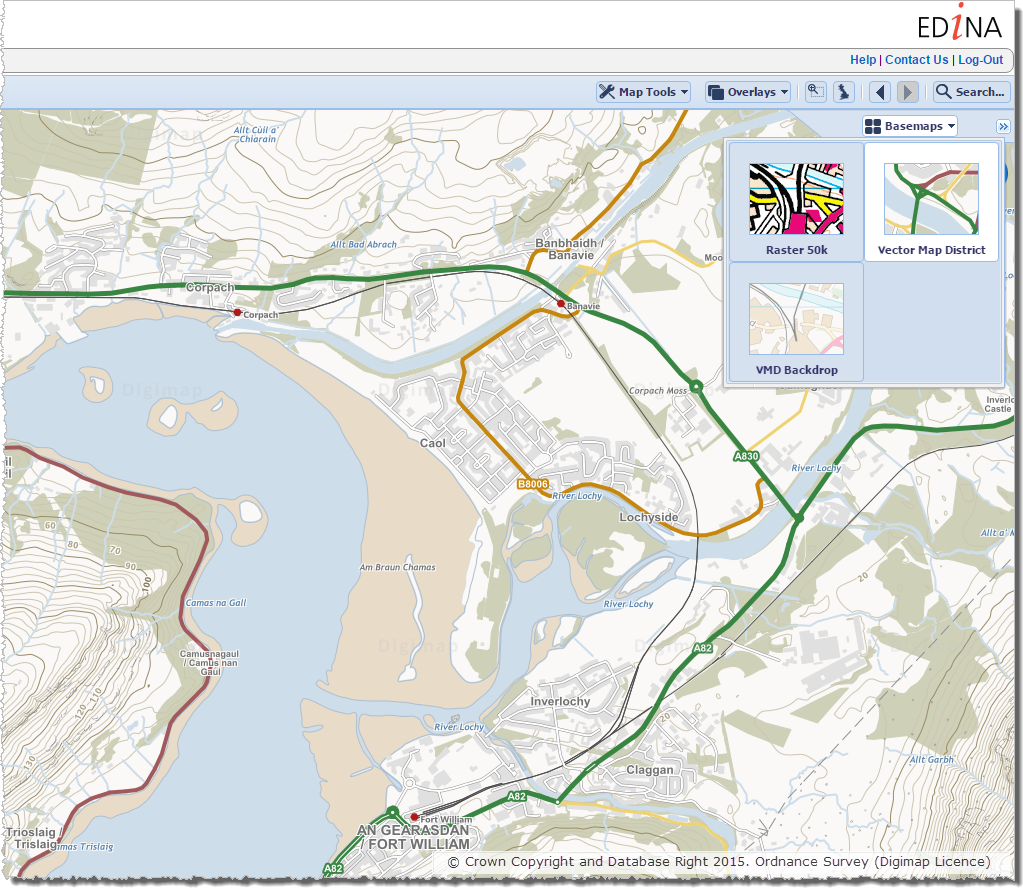
The vector version of VectorMap District (VMD) has been added to OS Roam and is available at the Local View zoom level (approx. 1:19,000) as an alternative map accessed through the Basemaps option:
The Local Plus View has been removed and the datasets available in the District and Local Views have been rationalised. Full details of the datasets available in each View can be found on this help page.
Accessing Product Help [all Roam clients]
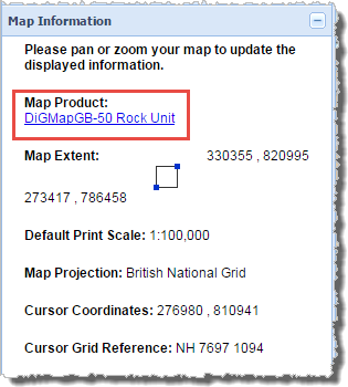
As well as updating the help pages to cover the changes listed above, we have also changed the Map Information panel in all Roam clients making it easier for users to get help on the particular map product(s) they are currently viewing in the map window.
Hyperlinks to help pages for each product have been added to product names in all Roam clients. The screen grab below was taken from Geology Roam where the hyperlink takes the user through to a help page dedicated to the map product currently displayed in the map window (DiGMapGB-50 Rock Unit):
We hope you enjoy using these new features, and if you have any suggestions for improvements to the service please get in touch:
Digimap’s new registration system was released on the 28th of January, we hope you’ll agree that it is a huge improvement over the previous version.
Users no longer have to wait up to 48 hours for registrations to be approved, they simply have to click a link in an email sent to them after filling in the registration form.
It already has its fans leading one site rep to say “I love the new registration system!” and another told us “Congratulations on instant registration for students. This is going to be very popular.”
The new instant access system is much more inline with user expectations from online services. Removing the need to wait overnight (or longer over weekends) to gain access has been very popular and has resulted in a significant increase in registrations during February. Over 6000 registrations were processed through the new system at all times of day and night!
We now need your help to make sure that the support material at your institution is up-to-date and that your students know that they can have access to the service the same day.
There is a full description of how to register using the new system in the help pages which guides you through the process:
If you are responsible for any local support pages, lecture notes, practical guides and any other course material please make sure these get updated. We actively encourage the incorporation of the images and text from the help page in any material produced. Please can you circulate this information as widely as possible to ensure that all users have up to date guidance.
One final plea is that you highlight the importance of entering the correct email address when registering. This should be an email address that is used regularly and it should be spelt correctly!
In January 2013 the OS MasterMap®, Boundary-Line™ and Code-Point® data products will be available from the Data Download service. We have tried to keep the changes necessary to accommodate these products to a minimum as the current interface has proved so successful (190,000 map tiles and files downloaded Nov 2012).
Here is a list of the changes and additions you will see in the interface; please note that they may still be subject to some change prior to launch.
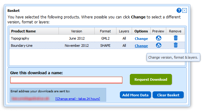
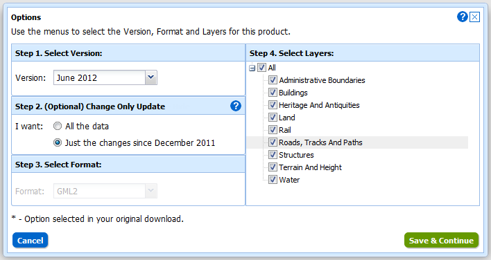
Both Boundary-Line and MasterMap have layers so we have had to make changes to the basket:
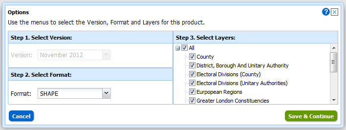
Instead of selecting Version and Format using drop-down menus there is a new pop-up for changing both these and the layers for each of the products in your basket. You can access this pop-up by clicking on the Change link in the Options column:
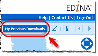
We have also improved the “My Account” section which is now called “My Previous Downloads”:
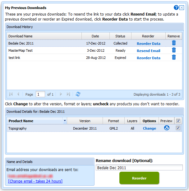
Once in the interface you can access any of your past downloads and reopen them at the basket stage:
It is now much easier to update your previous downloads to the latest version, get the same data in a different format or simply reorder data you have previously taken. In addition to these functions we have incorporated the ability to make Change-Only-Updates (COUs) to MasterMap Data:
Both Boundary Download and MasterMap Download will be kept in service for a transition period but as there are so many benefits to using Data Download we hope everyone will make the switch quickly. We expect to have switched off these services by the end of April.

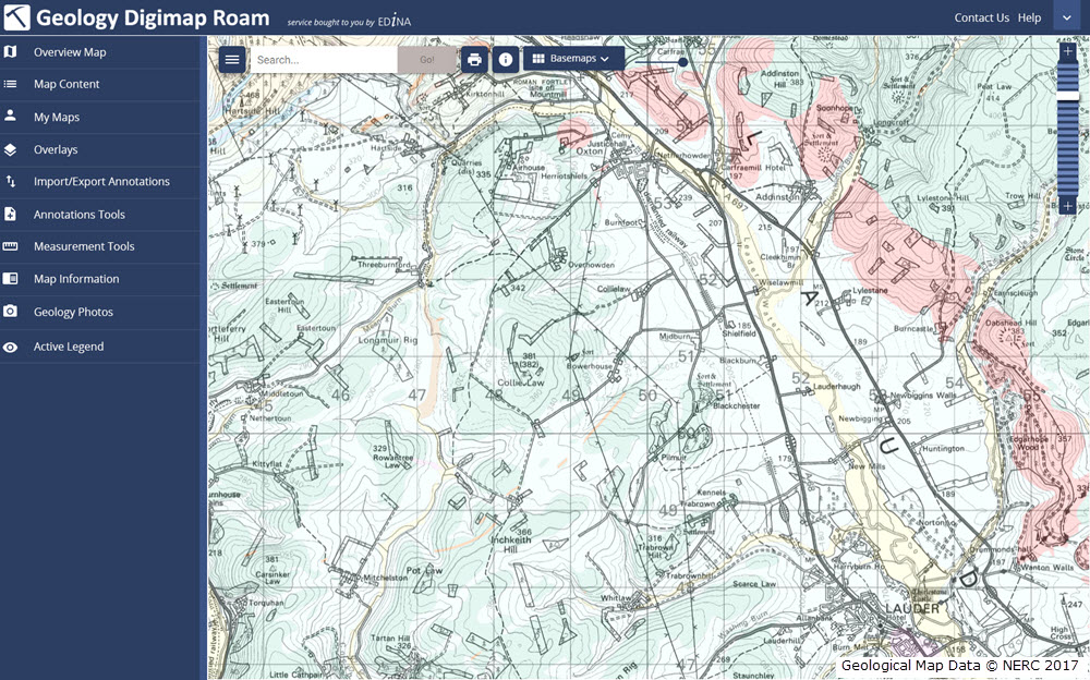

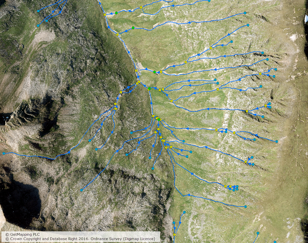
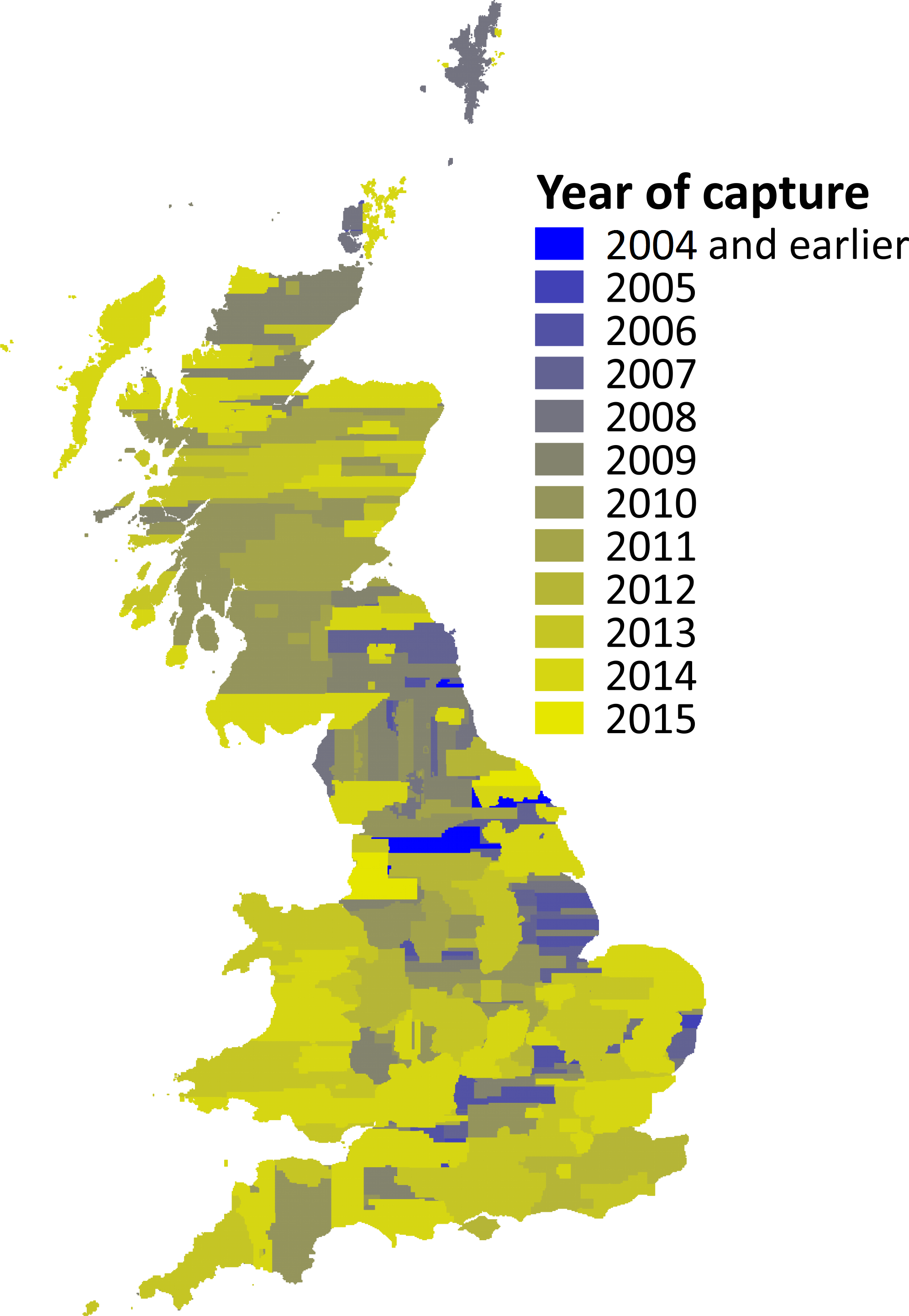
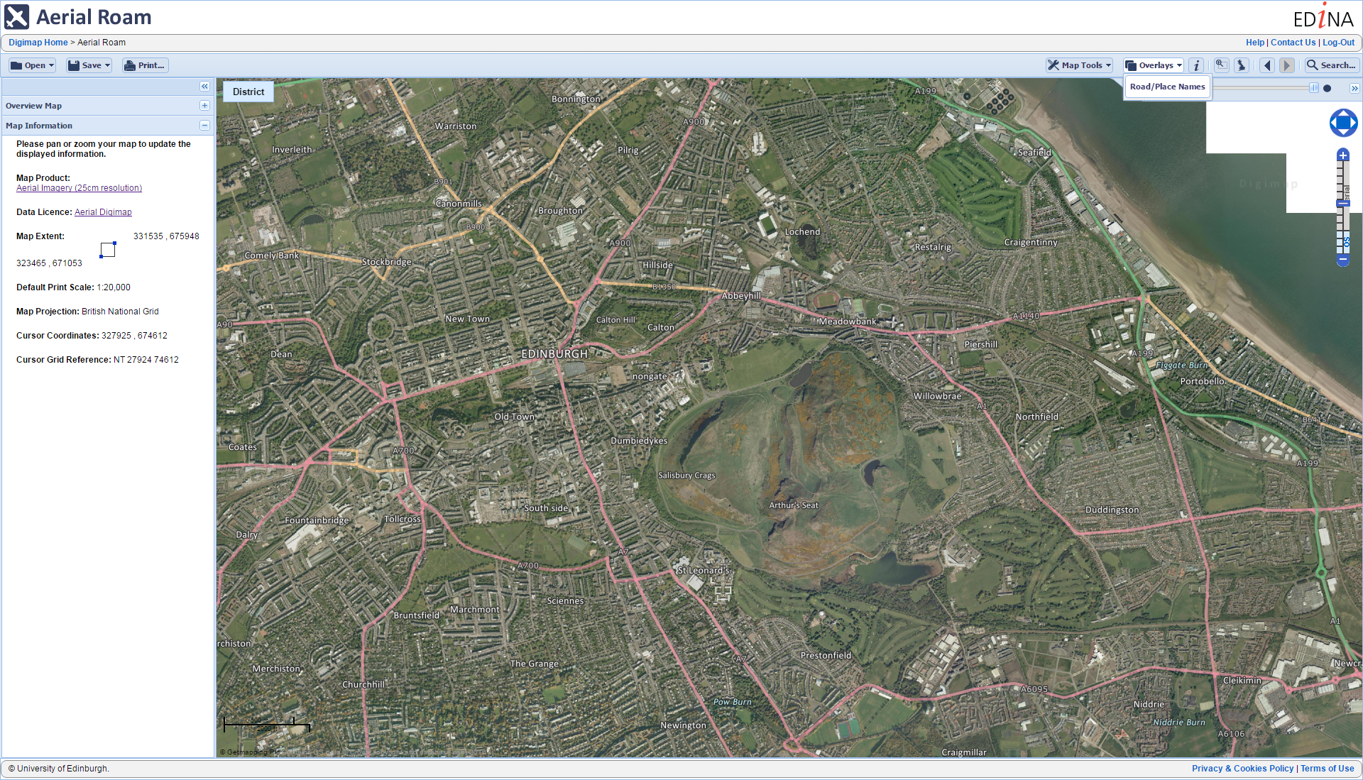
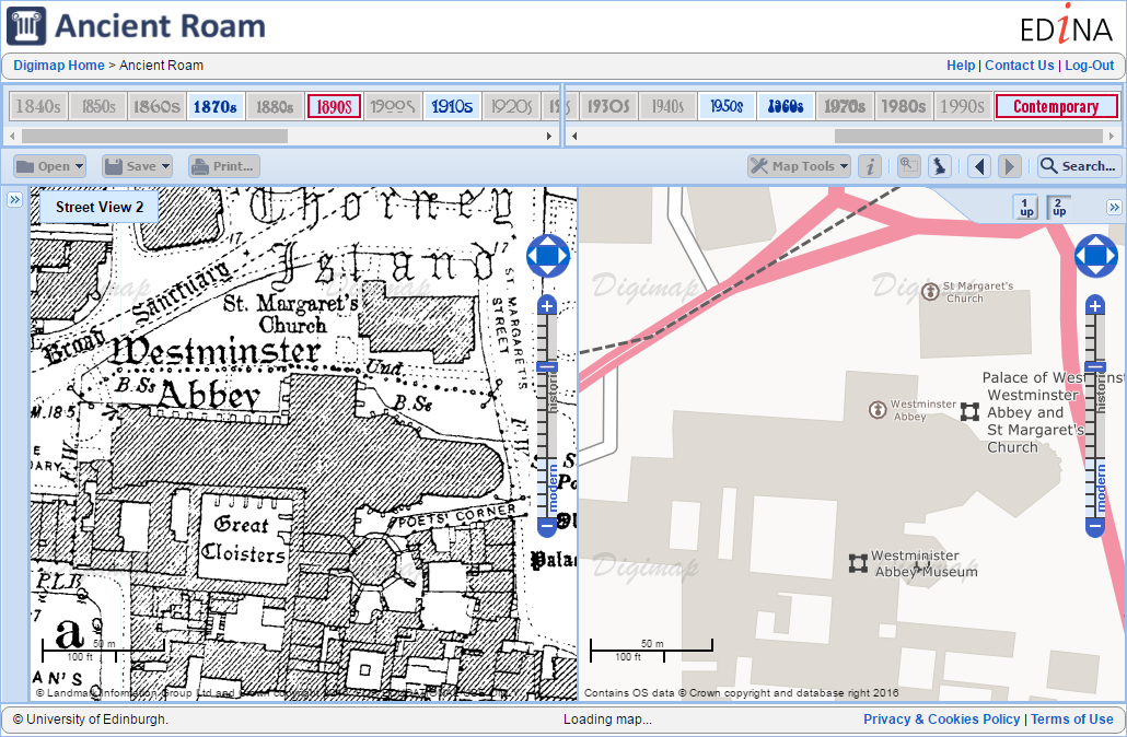
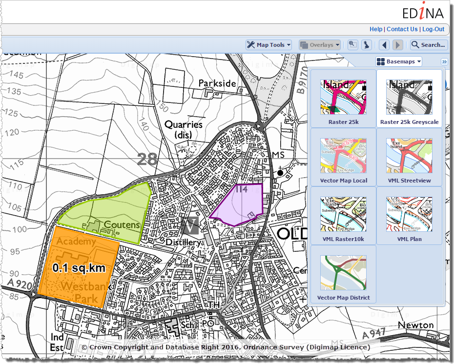
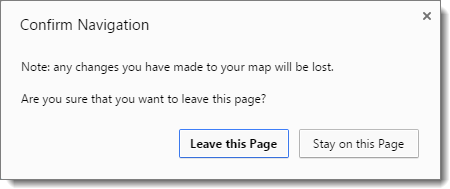
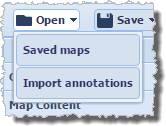
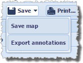
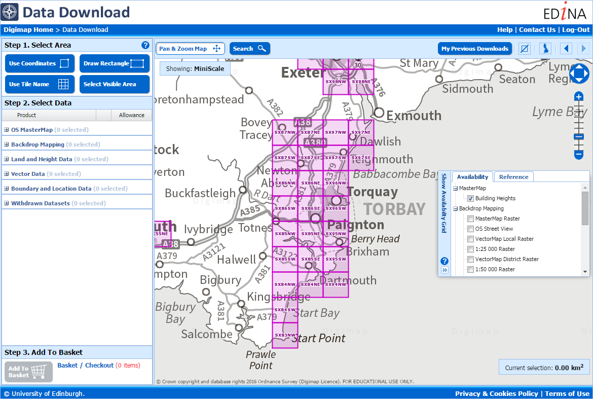
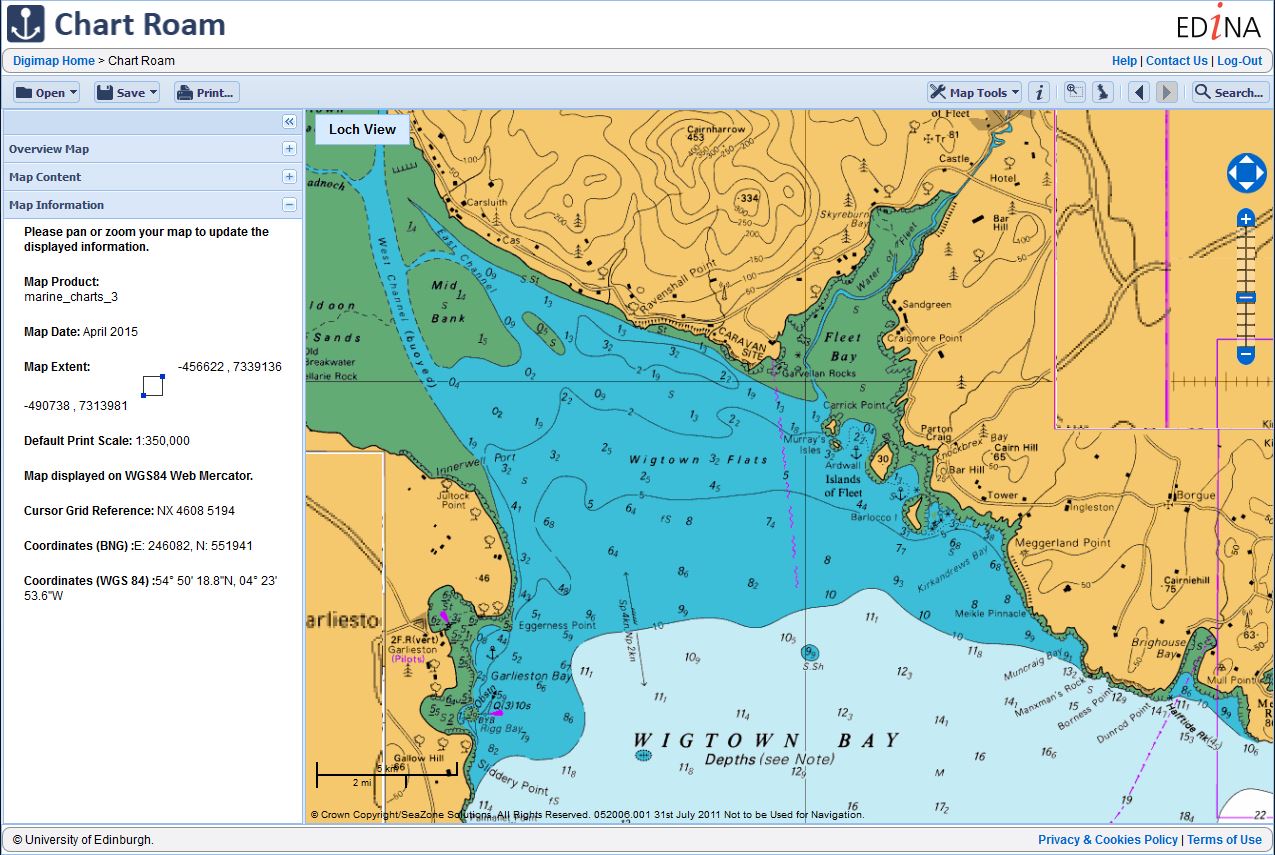
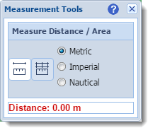 Chart Roam displays marine Hydrographic Charts from