Any views expressed within media held on this service are those of the contributors, should not be taken as approved or endorsed by the University, and do not necessarily reflect the views of the University in respect of any particular issue.
Digimap is an online map and data delivery service, available by subscription to UK Higher and Further Education establishments. Operated by EDINA at the University of Edinburgh, Digimap offers a number of data collections, including Ordnance Survey, historical, geological, aerial photography, LiDAR, marine maps, land cover mapping, global mapping and census data. For more information about Digimap go to our website: https://digimap.edina.ac.uk Background image Contains OS data (c) Crown Copyright and database right 2022
EDINA is pleased to announce the release of Digimap OpenStream – a web service delivering OS OpenData to the UK academic sector using open standard WMS technology.
Digimap OpenStream is an EDINA Digimap value-added service freely available to the academic community. Access is not restricted to registered Digimap users, although a one-off online registration is required. The OS OpenData offered is accessible 24/7 and users are able to embed it into their own application software without the overheads of downloading and managing large quantities of data.
Digimap OpenStream provides access to the following OS OpenData products:
MiniScale®
1:250,000 Scale Colour Raster
OS Vector Map™ District (Raster)
OS Street View®
Details of the Application Programming Interface (API) are provided along with simple guides illustrating how to use the service within popular GIS software.
EDINA has released Geology Roam; a new mapping facility within the Geology Digimap Collection. Geology Roam is based upon the Roam mapping facility from Digimap’s OS Collection and includes standard features such as fixed scale map views, ‘slippy maps’, map content customisation, searching by place name, postcode and grid reference, bookmarking and comprehensive help.
Geology Roam contains BGS DiGMap-625, DiGMap-250 and DiGMap-50 geology datasets and Ordnance Survey backdrop mapping. The geological data includes bedrock, superficial deposits, mass movement and faults.
Key features of Geology Roam include the ability to decrease/increase the opacity of the geology data over the Ordnance Survey back-drop map. A single click on the map will query the geology data and display details about the bedrock and any superficial deposits found at that point.
Geology Roam features a new printing interface that will become standard in all the Roam mapping facilities across Digimap. The new printing interface enables you to resize and reposition the map, and to add a map title and National Grid lines.
Beta Service
Currently available as a BETA service, we encourage you to give us feedback on the usability of Geology Roam so that issues you raise can be factored into ongoing development over the coming months. As well as responding to any issues you report, the following additional functions will be introduced:
Geological area (polygon) highlighting when clicking to obtain feature information, to make it easier to identify the extent of any geological feature to which the reported information corresponds.
Map based links to a Geology Photography Collection (JIDI Images). Icons will appear over the geology maps to indicate the availability of geological feature photographs for that location. Click on the icon to view these photographic images within the Geology Roam application.
Introduction of the BGS Rock Lexicon as an Independent application Geology Roam will run in parallel with the existing Geology Mapper during the Beta phase, after which Geology Mapper will be withdrawn (Dec 2010).
The existing mapping application will be withdrawn in December 2010 and will be wholly replaced by Geology Roam.
EDINA would welcome feedback on the service and on these proposed developments. Please contact us on edina@ed.ac.uk or 0131 650 3302.
EDINA welcomes the release of Ordnance Survey datasets for free use and re-use. We are actively working to realise to the full the opportunities offered by this new policy for the enhancement and development of new and existing services for research and education.
As many will already know the Government published details on 31 March 2010 of the package of datasets and products from Ordnance Survey that are now available under OS OpenData – see http://www.ordnancesurvey.co.uk/oswebsite/opendata/. The list coincides partially with the datasets currently available through EDINA Digimap – see below. Note especially that OS MasterMap, the large-scale vector data, is only available through registration with EDINA Digimap.
The key task for EDINA Digimap is to provide ease and continuity of access to a whole range of geo-spatial datasets, including re-use in materials that are shared in research and teaching. We are therefore seeking clarification from Ordnance Survey regarding the licence terms that can now apply to the data available through Digimap which are now covered under OS OpenData.
The release of many Ordnance Survey datasets as open data is also good news for Unlock, the EDINA service which is there to help you geo-enable research data and other Internet-accessible documents and images. Unlock, and its predecessor GeoCrossWalk, were previously limited by license to academic use only. Relevant datasets now regarded as open data, including Boundary-Line, Code-Point® Open and the 1:50 000 gazetteer of place names, can now be used by Unlock Places, Unlock Text and Unlock Geocodes.
We are keen to learn from users of Digimap how you wish us to take best advantage of these changes in availability and licensing. Contact us by email on edina@ed.ac.uk or leave a comment on this blog.
Product Name
EDINA Digimap
OS OpenData
OS MasterMap Topography
Yes
No
OS MasterMap ITN
Yes
No
1:10 000 Scale Raster
Yes
No
nearest equivalent is OS StreetView
1:25 000 Scale Colour Raster
Yes
No
1:50 000 Scale Colour Raster
Yes
No
1:250 000 Scale Colour Raster
Yes
Yes
MiniScale®
Yes
Yes
Meridian™2
Yes
Yes
Strategi®
Yes
Yes
Land-Form PANORAMA® Contours
Yes
Yes
Land-Form PANORAMA® DTM
Yes
No
Land-Form PROFILE®
Yes
No
Boundary-Line®
Yes
Yes
Code-Point®
Yes
No
CodePoint® with Polygons
Yes
No
Code-Point® Open
(point data only; subset of Code-Point®)
MiniScale and 1:250 000 Raster data are now available in Digimap’s Ordnance Survey Collection Data Download facility.
The datasets have been available from the ShareGeo service for some time, but are now also available from within Digimap. In addition to the new products you can now also:
download the OS Land-Form PROFILE, 1:10 000 Contour data in DXF format
download Shapefile and MID/MIF versions of Meridian2 data
The new Meridian2 formats have their own entry on the Product & Format page of Data Download. These formats are available as national coverage, with a single download covering the whole of Great Britain. The NTF and DXF formats are still available as individual tiles.
Land-Line style maps available in Carto
Maps of OS MasterMap data in Carto can now be styled to look like previous Land-Line.Plus maps. This is particularly useful for black and white printing or to recreate Land-Line.Plus data for comparison with older printed maps.
Yesterday, Tuesday 26 January 2010, some changes were made to Digimap. These are detailed as follows:
1. Classic removed from Ordnance Survey Collection.
As advertised on 5 October 2009 and 6 January 2010 this old facility has been removed and replaced by the new Roam facility. You can find a demonstration of Roam on the EDINA website: Roam demonstration
2. Historic Digimap “preview map sheet” button has been removed.
This function used out-of-date technology to render the original historical map sheets in the browser window. It was extremely slow and was dependent upon software installed on a machine which is being decommissioned. It is much quicker and more user-friendly to download the map sheet required and view it locally.
3. Marine Digimap Hydrospatial data updated.
The 2009 version of SeaZone’s Hydrospatial data is now available through Hydrospatial Download. Late delivery of the data has meant a delay of the release from September 2009 to January 2010.
On 26 January, the Digimap Classic mapping facility available in the OS Collection will be removed and will no longer be available for use. NOTE: ALL OTHER DIGIMAP FACILITIES WILL REMAIN AS THEY ARE.
Any maps present in your Classic Map Chest on 26 January will be lost. Please ensure that you print or save any maps that you require before 26 January. Please contact the EDINA Helpdesk (edina@ed.ac.uk) if you require any assistance in saving or printing maps from Classic.
The new Roam facility (released in October 2009) replaces Classic as the standard mapping facility in Digimap OS Collection. Key features of Roam include: 12 fixed scale map views, click-and-drag navigation or “slippy maps” and enhanced printing options enabling you to generate printable PDF maps in landscape or portrait and A4 or A3 size. Roam is a significant improvement on Classic, providing many enhanced futures and an easier to use, more intuitive user interface.
Today, Monday 5 October, a new mapping tool is available to all registered users, through Digimap’s Ordnance Survey Collection.
Roam, the new mapping facility, is available as a BETA service and will therefore be subject to various improvements over the next few months. Planned changes include:
– additional print formats as alternatives to PDF
– inclusion of scalebar on printed maps
– provision of scale and extent indication on screen maps
– adding a “My Maps” function for bookmarking maps
Roam offers “click and drag” functions to locate your map, 12 map views at different scales, printing in PDF at both A3 and A4 sizes, search by place name, postcode or grid reference, seamless scrolling through the fixed scale maps and 5 customisable map views. You can access Roam from the icon above Classic in Digimap’s Ordnance Survey Collection home page.
We hope you will use the new facility and let us know what you think of it. There is a link within Roam for you to report any feedback you have (positive and negative). You can also email us on edina@ed.ac.uk or telephone us on 0131 650 3302.
Roam will replace the current Classic facility in January 2010.
New data
On Thursday 17th September EDINA released all available updates for data provided through Digimap’s Ordnance Survey Collection. Details of the versions of all the data offered can be found on the EDINA website here. The Digimap licence also now offers MiniScale and the OS 1:250,000 scale colour raster data. These are currently available through ShareGeo and will be added to the Data Download as soon as possible.
Architectural Changes
As well as updating the data, other significant changes have been made to the underlying technologies supporting Digimap. In short, we have replaced the entire GIS architecture which produces the maps you see online.
The new software, from Cadcorp, offers a number of benefits to both EDINA and end users of Digimap. As well as enhanced quality maps and faster map generation online, the printed output gives crisp, clear maps as PDF files. EPS files are no longer available from any facility within Digimap’s OS Collection, including Carto, but EDINA is working on the provision of additional formats to PDF.
New mapping facility: Roam
With the arrival of the new GIS software, EDINA has also developed a new mapping facility, called Roam. Still in a development phase, Roam offers the usual search functions as well as “slippy maps”, the click-and-drag function used to position a map, familiar to users of other popular online mapping facilities. It is easier to locate your map, easier to zoom in and out, and now offers maps at 12 different fixed scales. An additional small scale Ordnance Survey mapping product, MiniScale, has been included, and other datasets (e.g. Strategi and OS MasterMap) are available at more than one fixed scale.
Currently Roam is available as a Beta facility to site representatives only until Monday 5th October, when it will become available to all registered users of Digimap’s Ordnance Survey Collection. Roam is available from the OS Collection Home page; you will find the new icon next to those for Classic and Carto. It will be greyed out if you don’t yet have access to it.
Roam will run in Beta alongside the current Classic facility until January 2010 when Classic will be withdrawn entirely. Regular updates will be made to Roam to add new functionality, such as MyMaps, prior to its release as a full service in January 2010.
If you have any questions about this email or about Digimap in general, please do not hesitate to contact the EDINA Helpdesk on edina@ed.ac.uk
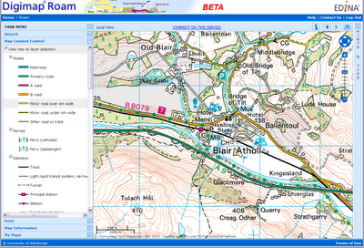
As indicated in a previous post, EDINA is creating a new version of the existing Classic mapping facility.
A sneaky peek at the new interface under development....
Given that the new facility works in a very different way, we would like to give it a new name. We have a number of suggestions, and would like to know your views on them. To this end, we have posted a poll on this blog (look to the top right hand side of this window) for you to vote with.
There are a number of things we need to take into account in choosing a name. For example:
1. It needs to give the mapping facility an identity. When users contact our helpdesk asking for assistance with it, they need to be able to refer to it by name with confidence that we will know what they are referring to. Similarly, our helpdesk need to be confident that they understand which facility a user is talking about, and using an easily identifiable and catchy name for it is an easy means to that end.
2. It needs to be memorable – users need to know which facility they are using.
3. It needs to be unique, not used by any other mapping organisation for a mapping service or product.
Vote on the blog here, or if you would rather, send us an email with your ideas. Thanks for your help!
The current version of Digimap’s Classic facility (available through the Ordnance Survey Collection) is currently undergoing both a facelift and some reconstruction work!
Later this year we will be introducing “slippy” maps (drag the map with your mouse to move it around) and some new ways of saving your maps and producing printed copies. The new facility will offer the same maps and the same functions as those currently available but will be easier and more intuitive to use. Everyday use of online mapping technology has grown dramatically since the current version of Classic was released. Users’ familiarity with online mapping has increased and there are now common expectations of how map services online should work. The current re-engineering aims to accommodate these changes and build a service which meets those expectations.
Although this is still work in progress, below is a sneak preview of how the new version might look.
EDINA will operate both new and existing versions of this facility in parallel to ensure that a smooth transition is made between them. If you have teaching materials or help pages which are currently based on the existing version, there will be plenty of time to update them before the existing version of Classic is withdrawn.