Any views expressed within media held on this service are those of the contributors, should not be taken as approved or endorsed by the University, and do not necessarily reflect the views of the University in respect of any particular issue.
Digimap is an online map and data delivery service, available by subscription to UK Higher and Further Education establishments. Operated by EDINA at the University of Edinburgh, Digimap offers a number of data collections, including Ordnance Survey, historical, geological, aerial photography, LiDAR, marine maps, land cover mapping, global mapping and census data. For more information about Digimap go to our website: https://digimap.edina.ac.uk Background image Contains OS data (c) Crown Copyright and database right 2022
The Digimap team are hosting a free webinar, on Wednesday 26 April 2017, from 1-1:30pm.
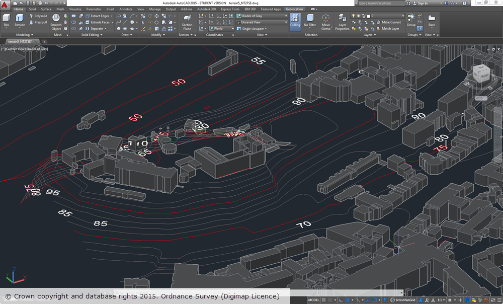
3D model showing bedrock geology of the Cuillin hills in Skye with Aerial Imagery draped over OS Terrain 5 DTM.
The session will give an overview of how to create 3D models in common GIS and CAD packages (ArcGIS Pro, QGIS and AutoCAD) using data downloaded from Digimap.
The session will look at the datasets available from Digimap that are of use for 3D modelling.
You will also have the opportunity to ask questions on any aspect of Digimap.
Registration is required – please note that spaces are limited, so it’s advisable to register early.
As many of you may be aware, the number of users of the Digimap service using CAD systems has increased considerably over the years. As this user base has grown we have endeavoured to make the data we provide as easy to use as possible in these systems. As part of this effort to continually improve the service we offer, we have made some considerable enhancements to the products we offer for use in CAD systems.
Part of the problem is that there is a proliferation of systems in use under the general banner of ‘CAD’ systems, including AutoCAD, Revit, Rhinoceros, Vectorworks to name a few. A common factor between these systems is that they can accept vector data in DWG format, however, the way that DWG data is handled can vary between systems.
A number of our products in DWG format were loading into CAD systems but some were not correctly spatially referenced. This meant that although the data looked fine and worked perfectly well on its own, but it was difficult to overlay or integrate it with other datasets. We have now fixed this issue, so that it is possible to overlay common products together much more easily.
To accompany the DWG map data we also provide Digital Terrain Model (DTM) data to allow you to create a landsurface to loacte buildings and infrastructure on. In the past we only provided the OS Terrain 5 DTM in a format that was not so easily used in some CAD systems. To remedy this, we are now delivering OS Terrain 5 DTM in the XYZ format that can be used in most CAD systems.
These are the Changes we have made:
All data available as DWG should overlay correctly where appropriate in AutoCAD Map 3D, AutoCAD, AutoCAD Civil, Revit and Rhinoceros.
All data has the correct Spatial Reference (British National Grid) and Units (metres).
OS Terrain 5 Contours are available as 3D Polyline data which is suitable for creating surfaces in Revit and Rhinoceros 5.
OS Terrain 5 DTM is available in an XYZ format which can be used to create surfaces in AutoCAD and Rhinoceros 5.
OS MasterMap Sites Layer is now available in DWG.
OS MasterMap Topography Layer Building Height Attribute data on top of OS Terrain 5 Contours
We have updated our help pages in line with these changes and recommend that you consult the AutoCAD FAQ page which has further details for how you can load Digimap data in to common CAD packages.
We hope our CAD users find these changes useful but if you have any questions about using Digimap data in a CAD system please let us know. Similarly if you can provide us with any information about using Digimap data in a CAD system we would be very pleased to hear from you.
We are pleased to announce the release of DWG versions of both OS Terrain™ 5 (vector) and OS MasterMap® Topography Layer Building Height Attribute, which makes their use in CAD applications much easier and quicker.
Recently we have been working to produce DWG versions of the detailed vector dataset OS Terrain™ 5 and the popular Building Height Attribute component of OS MasterMap® Topography Layer. Both these datasets have proved popular with CAD users for detailed modelling applications but until now using them has proved time-consuming as many steps were required to convert them in to a format suitable for use in CAD applications.
OS Terrain 5 Vector
OS Terrain 5 Vector is dataset consisting of contour lines with five metre vertical spacing and spot heights (point features). The dataset also includes contours for mean high and low water around coastal areas, along with labels for both spot heights and contours. OS Terrain 5 is the most detailed height dataset available from Ordnance Survey. A Digital Terrain Model (DTM) version is also available in ASCII grid format and can be downloaded through Digimap.
Building Height Attribute (BHA)
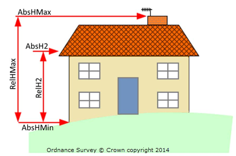
As with the other BHA datasets provided through Digimap the DWG version is supplied as a dataset of building polygons together with the building height attributes supplied by OS in the latest alpha release of their Building Height Attribute dataset (December 2014 at the time of writing). The DWG dataset is a 3D dataset which uses two of the height attributes supplied by OS to create the 3D features. The base height of buildings is set using the value of the AbsHMin attribute and the roof height is defined by the AbsH2 attribute:
All height attributes supplied by OS, as indicated in the image above, are included as XDATA which can be readily viewed in CAD applications.
Note: the DWG BHA dataset is not supplied with a terrain surface so the building features will appear to float above the surface if it is displayed without a suitable terrain surface. We recommend using either OS Terrain 5 or OS Terrain 50, both of which can be downloaded from Digimap.
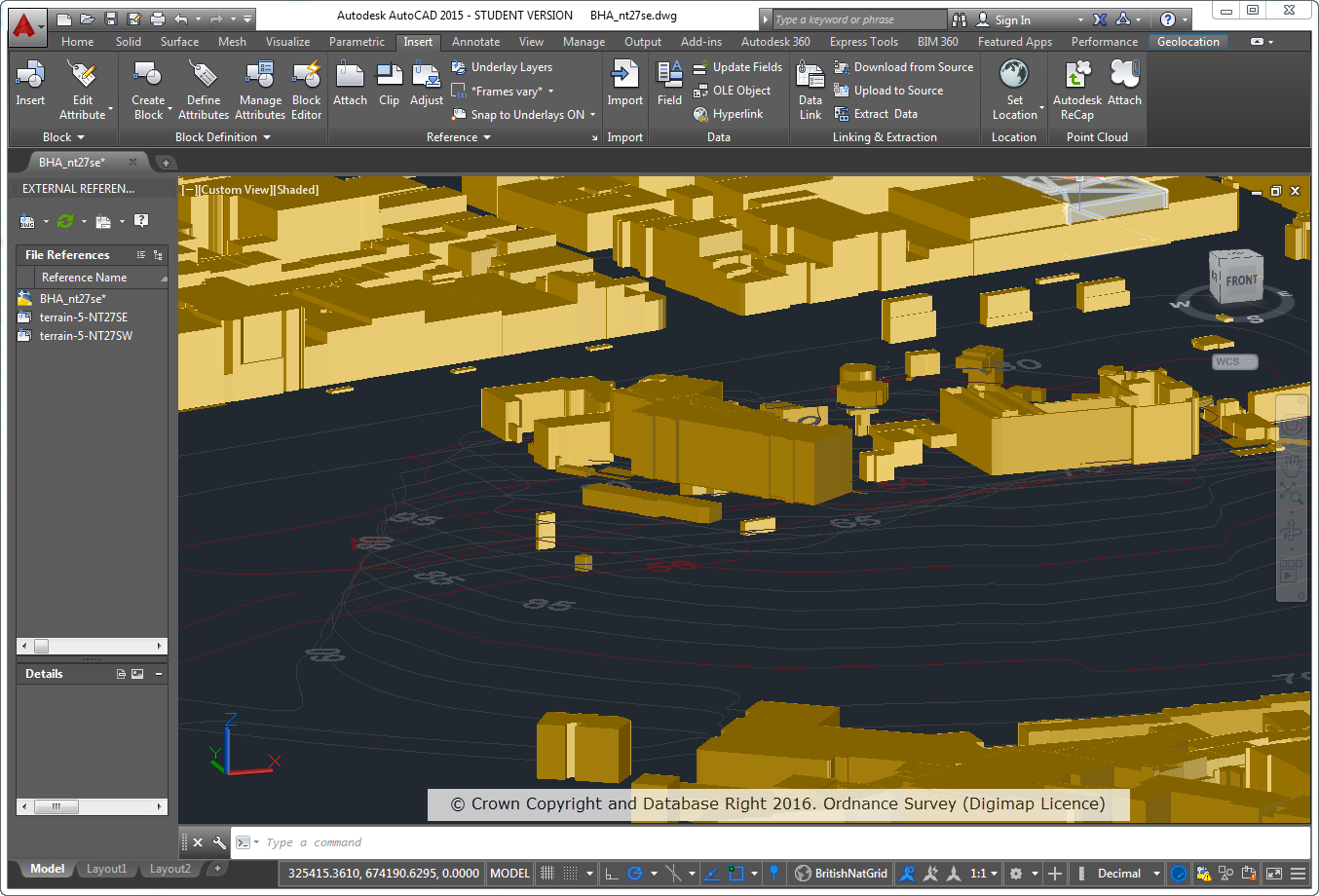
The image below shows OS Terrain 5 vector overlaid with BHA in AutoCAD 2015 for the area around Edinburgh Castle. Both datasets were supplied by Digimap in DWG format and required no manipulation or processing in order to display them.
OS Terrain 5 vector and OS MasterMap BHA datasets are supplied on a 5x5km grid, so you may receive multiple multiple files if your area covers more than one 5km grid square.
We hope this makes it much easier to use the data and we welcome any feedback you may have.
Until now anyone wanting to use OS MasterMap® Topography data in CAD software would have to convert their data, often a lengthy and complicated process. Now you can simply download the OS MasterMap Topography Layer in DWG format directly from Data Download. The DWG data should open in most CAD software such as AutoCAD, Vectorworks and ArchiCAD.
We always knew it wasn’t that easy to convert OS MasterMap data for use in CAD, the conversion software has a lot of options and can confuse at the best of times. The conversion software also doesn’t work on Apple Mac computers which are a popular choice with CAD users. However, we redoubled our efforts to provide DWG format data when we heard that some of our users were making PDF maps of OS MasterMap data and then manually digitising them from the screen… something had to be done!
Incorporating a conversion process into Data Download has not been simple and can produce some very large file sizes, especially if you need data for a busy urban area. Please only take enough OS MasterMap as necessary, or your computer may run out of memory when you work with the data.
Selecting DWG format
To get your data in DWG format simply follow the usual steps for making an order in Data Download:
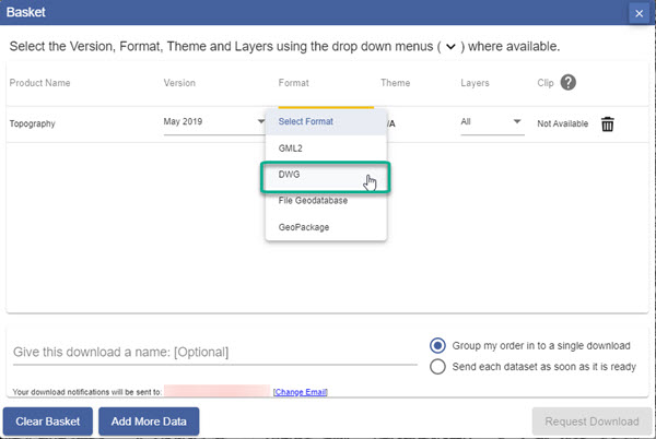
Once you have added your OS MasterMap Topography data to the basket, use the drop down arrow in the Format column.
Select DWG format from the available formats.
Selecting a theme and layers
You can select one of two themes for your OS MasterMap topography data. Standard has full colour whereas Plan is in black and white with buildings outlined in red.
Note that you can also choose which layers of Os MasterMap data you wish to download – just select the Layers arrow and check the boxes next to the layers you need, e.g. Buildings, Rail, Roads etc.
Your OS MasterMap data will not need any conversion to open in most CAD software, enjoy playing with the vectors! Please let us know if you have any problems using this data or if you have suggestions as to how it could be improved.
Digimap will be holding a webinar this week, Wednesday 22nd February 10:30 to 11:30, for people who want to use MasterMap in CAD software. This is going to be especially useful for Architecture and Planning students or anyone else who uses CAD software. Attendance is free and only requires an up-to-date web browser. (Browser requirements and test page can be found here: Technical Details.)
All the booking and joining details can be found on the EDINA Training & Events page:
There are more webinars and training events planned for Digimap users this spring on the EDINA training and events page; for a “Digimap Only” list check the Training Events tab here on the blog:
As lots of people are currently working on projects and dissertations we thought we’d share a few tips on using the OS MasterMap data from Digimap.
NOTE: MasterMap Download will be temporarily unavailable as part of the ‘At Risk’ period on Monday the 22nd of August. It will also be unavailable for about an hour on either Wednesday 24th or Thursday the 25th of August as well. This is to allow for some essential hardware maintenance on the server that houses the Database. We are really sorry for any inconvenience this causes.
The MasterMap data available will be updated as part of our annual data refresh at the beginning of September. If you need the 2010-2011s data then please order in advance of Monday the 22nd to ensure you don’t get caught up with the maintenance.
Downloading the Data
Remember that if you just want MasterMap as a background map you can use the 1:1000 or 1:2000 Raster versions of the data. This is available from the Data Download facility:
Once you have downloaded your MasterMap Data you will most likely need to convert it into a format that your GIS can use. There are three main options to do this, InterpOSe, OSM2MIF and Productivity Suite, see the following link for more information: