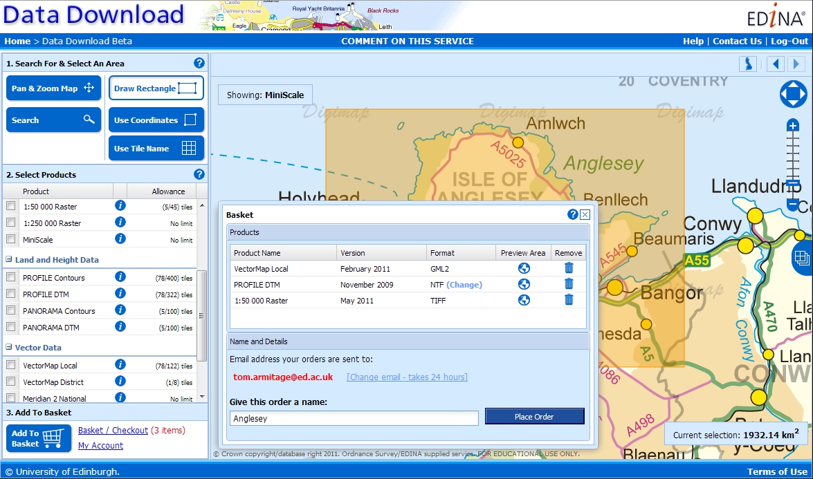
More Improvements Coming Soon

We have had another very busy month and so a new batch of improvements for the Digimap services will be coming soon.

Printing in Ancient Roam

At the moment downloading data or saving screen images are the only ways to use the maps available in Historic Digimap once you have logged out.  Soon you will be able to create and save high quality PDF maps from Ancient Roam for use offline. We hope you will find this a much better way to get the best quality mapping out of the service.

Ancient Roam PDF
A sample image of what a PDF from Ancient Roam may look like.

New Data in Digimap Roam

Since the arrival of the Ordnance Survey’s latest large scale product, VectorMap Local,  we have been busy thinking of the best way to include it in the Digimap Roam. We have decided to use it to create four new representations available at two different scale levels.

Here is a quick look at what the four different representations might look like:

VML standard
Vectormap Local- Standard
VML Streetview
Vectormap Local - Streetview
VML Plan
Vectormap Local - Plan
VML Raster10k
Vectormap Local - 1:10,000 Raster

We haven’t stopped there either; we are also going to add in Line Drawing style mapping to the two most zoomed in levels; for those who like their MasterMap plain and simple, similar to planning application maps.

MasterMap - Plan
MasterMap - Line Drawing

You will be able to select the different views from the Map Content Control Tab using a drop down list.Alternate representations choice Menu

For more information about VectorMap Local look in the Digimap help pages as it is already available for download:

OS Products: OS VectorMap Local

Annotation Tools in Geology Roam

For those of you who have tried the annotation tools in Digimap Roam it will come as no surprise that we are very pleased to announce that we are now working on adding the same functionality in Geology Roam. Again the annotation tools are a first draft and will have exactly the same functionality as Digimap Roam’s tools.

Geology Annotation Tools

Once they are released we’d really like to hear from you about which functions you use and what else you would like added. We are already hoping to add in some Geology Mapping symbols for you to add to the maps.

As an added bonus we are also putting in the measurement tools so you can measure areas and distances too, so you can tell how long a fault is or what area is covered by different rock types.

YouTube Videos Available to Edit and Reuse

YouTube IconAll our YouTube videos are now available under the Creative Commons licence. This means that you can copy, distribute and create derivative works from them if you give us credit. The videos are now available in the YouTube video editor so you can use them to help other users or show people what you have learned to do.

For information on what the Creative Commons licence means and how to edit the videos within YouTube go to this web page:

YouTube Instructions

We’d really like to hear from you if you have been using our videos; please send us an  email: edina@ed.ac.uk

If you have an idea for a video you’d like us to make you can join the discussion on our Facebook page: Facebook | YouTube Discussion

Geology Roam gets enhanced print maps and a new Active Legend.

We have been working on a few improvements to Geology Roam and have now added rock labels to print maps and a new beta active legend.

Print Labels

The print labels show the lexicon code for each of the rocks on the map, therefore allowing you to identify them on a paper map and distinguish rocks with similar colours. The codes are placed in the centre of the area of each rock, if the rock area lies at the edge of the map then they are place in the centre of the area shown.

The labels are added by checking the box on the Print Map page. Below is a sample of what the maps look like, click on the thumbnail to view a full size image:

Geology PDF showing labels

There is more information about the map labels in the printing section of the Geology roam help:

How to use Geology Roam: Printing

If you are using Safari use the following link and then use the index to get to the Printing section:

How to use Geology Roam

Active Legend Beta

The active legend allows you to reorder the entries in the legend alphabetically or by the number units of that rock type.  You can also click on the map to highlight rocks which will then be identified in the legend, this process works in reverse too, highlight rock on the map that have been selected in the legend. This functionality is still a beta version and we hope to extend the range of options available in the future. The image below shows the active legend at work, click on the thumbnail to view the full size image.

Active Legend in Geology Roam

Instructions on how to use the Active legend can be found in the Geology Digimap Help pages:

How to use Geology Roam: Active Legend

If you are using Safari use the following link and then use the index to get to the Active Legend section:

How to use Geology Roam

Annotation Tools now in Digimap Roam

The Annotation tools are now available to use in Digimap Roam.  We have a quick guide on what you can do with them on YouTube:

[youtube width=”640″ height=”390″]http://www.youtube.com/watch?v=PSkTZvMNyKU&hd=1[/youtube]

We also have a section in the Digimap Help Pages that describes how each of the different tools works:

Annotation Tools Help

Annotations ToolbarThese annotation tools are a first phase, to see what you find the most useful. We would like to hear from you about any changes or additions you would like making to the tools. Please send feedback to our help desk:

Mailto: EDINA help desk

Changes and Additions to Digimap on Tuesday 17th May

Digimap will be ‘at risk’ between 17:30 and 18:30 on  May 17th to allow for some service changes and improvements to be made. Access to the service will have to be disrupted intermittently during this period as we add in some new features and make some software upgrades.  We apologise for any inconvenience caused and hope that you find the new additions useful.

Along with new features being added on the 17th of May all print requests from Digimap Roam and Geology Roam will have to be made using the print button  Print Button at the top right of the map. We will be removing the print tab from the list on the left of the map on June the 21st, but until then it will carry instructions on where to find the print button.

Print Tab

We are removing the tab to make room for the new features we are planning to add into the list on the left in the future.  You may have noticed that it is already getting a little crowded in Geology Roam, with Geology Photos and an Overview Map being added since the service was launched, and there are more additions on the way.

New Annotation Tools: Coming Soon

EDINA has been busy over these last few months creating some significant new features for Digimap Roam. To go along with the measurement tools we added at the beginning of April we are now working on some annotation tools.

Annotations ToolbarThese tools will allow you to draw symbols, lines and polygons on the map; add text, labels and area values; and set the colour and style of the features you have added. The features you add remain the same geographical size when zooming in and out and you can include them on your PDF print maps.

Annotations in use
Final version may differ from the image shown above.

You can download a sample PDF map here: Sample Annotations

We hope to have the annotation tools added soon, please keep checking the blog or the Digimap Facebook page for further announcements.


Digimap for Schools wins Gold Award

EDINA are delighted to announce that the new Digimap for Schools service has been awarded the GOLD Certificate for the best overall resource in the the Geographical Association’s 2011 Publishers’ Awards.

The GA Publishers’ Awards aim to recognise material which is likely to make a significant contribution to geography in primary schools, secondary schools or colleges, and to encourage the creative development of new materials. Further information about the awards can be found here: http://www.geography.org.uk/news/publishersawards/

OS MasterMap in Digimap for Schools
OS MasterMap available through Digimap for Schools

The Award was presented at the Geographical Association’s Annual Conference at the University of Surrey, Guildford on Thursday 14th April 2011 to EDINA’s Director Peter Burnhill and Ordnance Survey’s Director General and CEO, Vanessa Lawrence.

Peter Burnhill said, “This Gold Certification from the Geography Association Publishers is  splendid recognition for all those who have worked together on Digimap for Schools to bring Ordnance Survey mapping into the classroom.

“At EDINA, which is based at the University of Edinburgh, we aim to  live up to your expectations and do for primary and secondary schools  what we have done so successfully for universities and colleges,  encouraging love of maps as well as helping to prepare students for the future.”

About Digimap for Schools
Digimap for Schools is a joint venture between EDINA (University of Edinburgh), Ordnance Survey and JISC Collections and provides easy access to a wide range of current Ordnance Survey maps including national coverage of OS MasterMap, Landranger and Explorer series. Also included are street level maps showing street names and road-atlas style maps.

Subscribing schools can use a seamless digital map of Great Britain at each scale available. Maps can be printed as PDF files at A3 or A4 size and in landscape or portrait orientation. Maps can be printed with an individual’s own map title and name included with the scale bar and school name and address. Search tools include postcode, place name or national grid reference and maps can be moved to centre on any chosen location within Great Britain. Map keys are available for each scale map to explain the symbols used within the map.

For information about Digimap for Schools, how to subscribe and links to a free trial demonstration version of the service, please check the following links:

The New Digimap Blog

This is the new Digimap blog and replaces our old Blogger site. From now on this will be one of the places that the Digimap team post news, information about updates and other useful things like tip and hints.  You can subscribe to the blog through the RSS feed:

http://digimap.blogs.edina.ac.uk/feed/

If you find a link to our old blog, please inform the administrator of the site that you found it on, or send us the URL and we will try to contact the site owner to get the link updated.

“How To” Videos on YouTube

You Tube IconWe have created some “How To” video clips and put them on YouTube for everyone to view. They show how to carry out various tasks with Digimap’s online maps and downloaded data.

You can see all the videos on the EDINA Digimap YouTube channel: http://www.youtube.com/user/EDINADigimap

If there are any particular aspects of the service for which you would like us to make a video, you can add them to the discussion on our Facebook page or email us directly at edina@ed.ac.uk.

Digimap is now on Facebook and Twitter

You can now follow the EDINA Digimap service on Facebook and Twitter, as well as keeping up to date here on our blog. Our Twitter feed can be found on @EDINA_Digimap and our Facebook page is at: http://www.facebook.com/edinadigimap

We will be posting news about the Digimap service, forthcoming events, service maintenance operations and new features and functions, all of which may be of interest to Digimap users. Don’t forget you can also start your own discussions about Digimap on the Facebook page and you can leave comments or queries on the blog.

If you click Like at the bottom of the left hand column on the Facebook page or follow us on Twitter you will be kept up-to-date with all the latest news.