Any views expressed within media held on this service are those of the contributors, should not be taken as approved or endorsed by the University, and do not necessarily reflect the views of the University in respect of any particular issue.
Digimap is an online map and data delivery service, available by subscription to UK Higher and Further Education establishments. Operated by EDINA at the University of Edinburgh, Digimap offers a number of data collections, including Ordnance Survey, historical, geological, aerial photography, LiDAR, marine maps, land cover mapping, global mapping and census data. For more information about Digimap go to our website: https://digimap.edina.ac.uk Background image Contains OS data (c) Crown Copyright and database right 2022
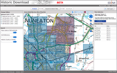
Launched as a BETA service on 20 April 2010, Historic Download is an entirely new facility allowing users to select and download larger quantities of historical map data.
The facility offers the capability to browse contemporary maps of the UK which have been shaded blue to indicate the coverage of historical maps of each series and edition. Areas of historical maps can be selected for download by clicking on the appropriate shaded polygons or by dragging a box to select multiple map sheets.
The interface has been designed to improve selection and retrieval of larger quantities of data for research projects. Build up a list of the data you need, choosing maps from different editions of a given product and take up to 200 maps in a single download.
EDINA welcomes feedback on this BETA service. You can contact us on edina@ed.ac.uk or 0131 650 3302.
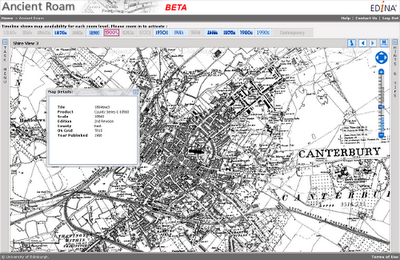
Ancient Roam is a new mapping facility within Historic Digimap. It is based upon the Roam mapping client available from Digimap’s OS Collection and includes the standard features such as fixed scale map views, ‘slippy maps’, searching by place name, postcode and grid reference, easy to use zooming and comprehensive help.
Key features specific to Ancient Roam include the ability to select historical maps from any decade (depending on map coverage and availability) using the Timeline along the top of the map window. Ancient Roam also offers an easier means of identifying and selecting maps in areas where County Series overlap at County boundaries. A single click on the map will also query maps to display the year the map shown was published along with other information about the map.
New Town Plan Maps
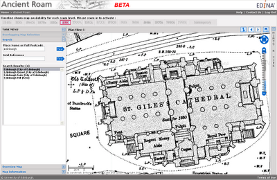
The large scale Town Plans are now available to view in Ancient Roam and download from Historic Download. The Town Plans are the largest scale historical maps available from Digimap offering great detail at 1:500, 1:528 and 1:1056 scales. The coverage of these maps is limited in that only settlements with a population greater than 4000 at the time of surveying were mapped. It is interesting to see what were regarded, then, as “urban” areas. The detail captured is enlightening; individual trees are marked in parkland and many industrial and commercial uses of land and buildings are noted.
Beta Service
Currently available as a BETA service, Ancient Roam will continue to undergo development over the coming weeks. Proposed additional functions include:
PDF map creation for printing
My Maps, to enable bookmarking screen maps for future reference
Multiple historical map views, to enable comparison of maps of different dates
Map fade slider, to show transition between maps of different dates
The ability to download the original Map sheet data which makes up your current on-screen map view
EDINA would welcome feedback on the service and on these proposed developments. Please contact us on edina@ed.ac.uk or 0131 650 3302
MiniScale and 1:250 000 Raster data are now available in Digimap’s Ordnance Survey Collection Data Download facility.
The datasets have been available from the ShareGeo service for some time, but are now also available from within Digimap. In addition to the new products you can now also:
download the OS Land-Form PROFILE, 1:10 000 Contour data in DXF format
download Shapefile and MID/MIF versions of Meridian2 data
The new Meridian2 formats have their own entry on the Product & Format page of Data Download. These formats are available as national coverage, with a single download covering the whole of Great Britain. The NTF and DXF formats are still available as individual tiles.
Land-Line style maps available in Carto
Maps of OS MasterMap data in Carto can now be styled to look like previous Land-Line.Plus maps. This is particularly useful for black and white printing or to recreate Land-Line.Plus data for comparison with older printed maps.
Yesterday, Tuesday 26 January 2010, some changes were made to Digimap. These are detailed as follows:
1. Classic removed from Ordnance Survey Collection.
As advertised on 5 October 2009 and 6 January 2010 this old facility has been removed and replaced by the new Roam facility. You can find a demonstration of Roam on the EDINA website: Roam demonstration
2. Historic Digimap “preview map sheet” button has been removed.
This function used out-of-date technology to render the original historical map sheets in the browser window. It was extremely slow and was dependent upon software installed on a machine which is being decommissioned. It is much quicker and more user-friendly to download the map sheet required and view it locally.
3. Marine Digimap Hydrospatial data updated.
The 2009 version of SeaZone’s Hydrospatial data is now available through Hydrospatial Download. Late delivery of the data has meant a delay of the release from September 2009 to January 2010.
On 26 January, the Digimap Classic mapping facility available in the OS Collection will be removed and will no longer be available for use. NOTE: ALL OTHER DIGIMAP FACILITIES WILL REMAIN AS THEY ARE.
Any maps present in your Classic Map Chest on 26 January will be lost. Please ensure that you print or save any maps that you require before 26 January. Please contact the EDINA Helpdesk (edina@ed.ac.uk) if you require any assistance in saving or printing maps from Classic.
The new Roam facility (released in October 2009) replaces Classic as the standard mapping facility in Digimap OS Collection. Key features of Roam include: 12 fixed scale map views, click-and-drag navigation or “slippy maps” and enhanced printing options enabling you to generate printable PDF maps in landscape or portrait and A4 or A3 size. Roam is a significant improvement on Classic, providing many enhanced futures and an easier to use, more intuitive user interface.
New data
On Thursday 17th September EDINA released all available updates for data provided through Digimap’s Ordnance Survey Collection. Details of the versions of all the data offered can be found on the EDINA website here. The Digimap licence also now offers MiniScale and the OS 1:250,000 scale colour raster data. These are currently available through ShareGeo and will be added to the Data Download as soon as possible.
Architectural Changes
As well as updating the data, other significant changes have been made to the underlying technologies supporting Digimap. In short, we have replaced the entire GIS architecture which produces the maps you see online.
The new software, from Cadcorp, offers a number of benefits to both EDINA and end users of Digimap. As well as enhanced quality maps and faster map generation online, the printed output gives crisp, clear maps as PDF files. EPS files are no longer available from any facility within Digimap’s OS Collection, including Carto, but EDINA is working on the provision of additional formats to PDF.
New mapping facility: Roam
With the arrival of the new GIS software, EDINA has also developed a new mapping facility, called Roam. Still in a development phase, Roam offers the usual search functions as well as “slippy maps”, the click-and-drag function used to position a map, familiar to users of other popular online mapping facilities. It is easier to locate your map, easier to zoom in and out, and now offers maps at 12 different fixed scales. An additional small scale Ordnance Survey mapping product, MiniScale, has been included, and other datasets (e.g. Strategi and OS MasterMap) are available at more than one fixed scale.
Currently Roam is available as a Beta facility to site representatives only until Monday 5th October, when it will become available to all registered users of Digimap’s Ordnance Survey Collection. Roam is available from the OS Collection Home page; you will find the new icon next to those for Classic and Carto. It will be greyed out if you don’t yet have access to it.
Roam will run in Beta alongside the current Classic facility until January 2010 when Classic will be withdrawn entirely. Regular updates will be made to Roam to add new functionality, such as MyMaps, prior to its release as a full service in January 2010.
If you have any questions about this email or about Digimap in general, please do not hesitate to contact the EDINA Helpdesk on edina@ed.ac.uk
Remember that you need to renew your institution’s subscription to Digimap’s Ordnance Survey Collection BEFORE 30 September 2009 in order to ensure continuity of service.
If your institution has not completed and returned the appropriate licensing forms by this date, access to Digimap’s Ordnance Survey Collection will be removed.
Owing to the way access is controlled under the UK Federation there will be no exceptions to and no leeway given for this date. If you have already requested an invoice, you still need to return the subscription forms to the address supplied on the forms by 30 September 2009.
On 1 August 2009, the Ordnance Survey Data Sub-Licence Agreement was extended and amended by a Variation Agreement. If institutions wish to continue their subscription to Digimap’s Ordnance Survey Collection, the Variation Agreement must be signed and returned by Wednesday 30 September 2009. Institutions not submitting renewal forms by this date will have access to the service removed. There will be no exceptions to this. Details of how to re-subscribe are given on the JISC Collections website.
When an institution re-subscribes to Digimap’s Ordnance Survey Collection, it agrees to the terms of the Ordnance Survey Data Sub-Licence Agreement AND the Variation Agreement. Some of the clauses in the Sub-Licence Agreement are superseded by those in the Variation Agreement. Both documents must be read in conjunction with one another, since one is not valid without the other.
EDINA has drawn up a set of Frequently Asked Questions to help you understand what the the Sub-Licence and Variation Agreements will permit in terms of map and data usage. These can be found at: http://edina.ac.uk/digimap/support/faq_oslicence.html
The following is a summary of the changes which are brought into effect on 1 August 2009 by the Variation Agreement. The original Sub-Licence Agreement holds good unless it has been amended by the Variation Agreement. Please read the Variation Agreement itself for full details of the amendments.
The definition of Authorised User has changed. An individual must fulfill three conditions in order to be an Authorised User. Individuals must:
be a student of, staff (both current or retired) of, or visitor to an Authorised Institution
be authorised by an Authorised Institution to access the Authorised Institution’s electronic information services via secure authentication; and
be registered with EDINA Digimap
Overseas Students are also specifically excluded from being Authorised Users, unless they are resident within the UK. Check the wording of the Variation Agreement carefully. Note also that it is the institution’s responsibility to ensure that students who are not eligible for access to this service are not given the means to access it. Under the UK Federation, EDINA is not able to check eligibility.
All references to Athens have been superseded by references to the UK Access Management Federation.
Class Registration is no longer possible. This has been the case since the introduction of the UK Access Management Federation in August 2008, but has now been formalised in this Variation Agreement. Assigning one username to more than one individual (as per a Class registrations) is not permitted under UK Federation policy.
Authorised Users are now explicitly permitted to share data with other Authorised Users, either in the same or another Authorised Institution. This was previously implicit, but has now been made explicit. Sharing data between Authorised Institutions is still subject to completion of the Transfer of Data form as specified in the original Sub-Licence Agreement (Schedule 7, section 8.1)
The Permissible Publication Sizes have been amended. These now offer a significant improvement on the previous restrictions to the size of maps published. For example, it is now possible to publish a map of Great Britain in electronic format. Please read Schedule 2 of the Variation Agreement for specific details of the new rules.
Two new datasets have been included in the agreement: MiniScale® and the 1:250,000 Scale Colour Raster. A full list of products available can be found on the EDINA website.
Both the Sub-Licence Agreement and the Variation Agreement are available from EDINA’s website:
Questions regarding the subscription process and the licence agreements should be directed at JISC Collections. Questions relating to the Digimap service should be directed at the EDINA Helpdesk.
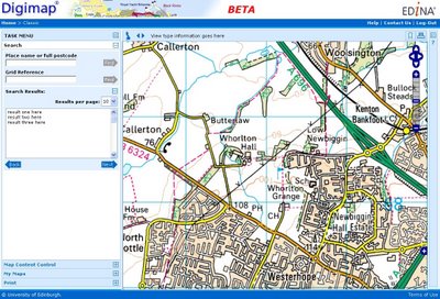
As indicated in a previous post, EDINA is creating a new version of the existing Classic mapping facility.
A sneaky peek at the new interface under development....
Given that the new facility works in a very different way, we would like to give it a new name. We have a number of suggestions, and would like to know your views on them. To this end, we have posted a poll on this blog (look to the top right hand side of this window) for you to vote with.
There are a number of things we need to take into account in choosing a name. For example:
1. It needs to give the mapping facility an identity. When users contact our helpdesk asking for assistance with it, they need to be able to refer to it by name with confidence that we will know what they are referring to. Similarly, our helpdesk need to be confident that they understand which facility a user is talking about, and using an easily identifiable and catchy name for it is an easy means to that end.
2. It needs to be memorable – users need to know which facility they are using.
3. It needs to be unique, not used by any other mapping organisation for a mapping service or product.
Vote on the blog here, or if you would rather, send us an email with your ideas. Thanks for your help!
Have you created geospatial data for your research project or teaching module?
If so, why not put it in ShareGeo and share it with other Digimap users?
ShareGeo is a facility in Digimap where users can share and re-use geospatial data, whether they have been derived from exiting Digimap data or created entirely from scratch.
Why should I put my data in ShareGeo?
increase the visibility of your research
share datasets easily with colleagues and peers
create a record of your data with simple metadata
manage your data for future use
Also, you will:
find datasets you may be interested in
save time by re-using existing data that others have created
What’s new in ShareGeo?
New datasets available in ShareGeo include: UK Digital Terrain Model (DEM), UK National Parks boundaries, Government Office Regions, Strategic Health Authority boundaries and many others.
A full list of all datasets in ShareGeo can be found here.
How do I access ShareGeo?
ShareGeo can be accessed by logging in to Digimap and following the link on the Collections page to ShareGeo. http://edina.ac.uk/digimap/