Any views expressed within media held on this service are those of the contributors, should not be taken as approved or endorsed by the University, and do not necessarily reflect the views of the University in respect of any particular issue.
Digimap is an online map and data delivery service, available by subscription to UK Higher and Further Education establishments. Operated by EDINA at the University of Edinburgh, Digimap offers a number of data collections, including Ordnance Survey, historical, geological, aerial photography, LiDAR, marine maps, land cover mapping, global mapping and census data. For more information about Digimap go to our website: https://digimap.edina.ac.uk Background image Contains OS data (c) Crown Copyright and database right 2022
This is the new Digimap blog and replaces our old Blogger site. From now on this will be one of the places that the Digimap team post news, information about updates and other useful things like tip and hints. You can subscribe to the blog through the RSS feed:
If you find a link to our old blog, please inform the administrator of the site that you found it on, or send us the URL and we will try to contact the site owner to get the link updated.
We have created some “How To” video clips and put them on YouTube for everyone to view. They show how to carry out various tasks with Digimap’s online maps and downloaded data.
If there are any particular aspects of the service for which you would like us to make a video, you can add them to the discussion on our Facebook page or email us directly at edina@ed.ac.uk.
You can now follow the EDINA Digimap service on Facebook and Twitter, as well as keeping up to date here on our blog. Our Twitter feed can be found on @EDINA_Digimap and our Facebook page is at: http://www.facebook.com/edinadigimap
We will be posting news about the Digimap service, forthcoming events, service maintenance operations and new features and functions, all of which may be of interest to Digimap users. Don’t forget you can also start your own discussions about Digimap on the Facebook page and you can leave comments or queries on the blog.
If you click Like at the bottom of the left hand column on the Facebook page or follow us on Twitter you will be kept up-to-date with all the latest news.
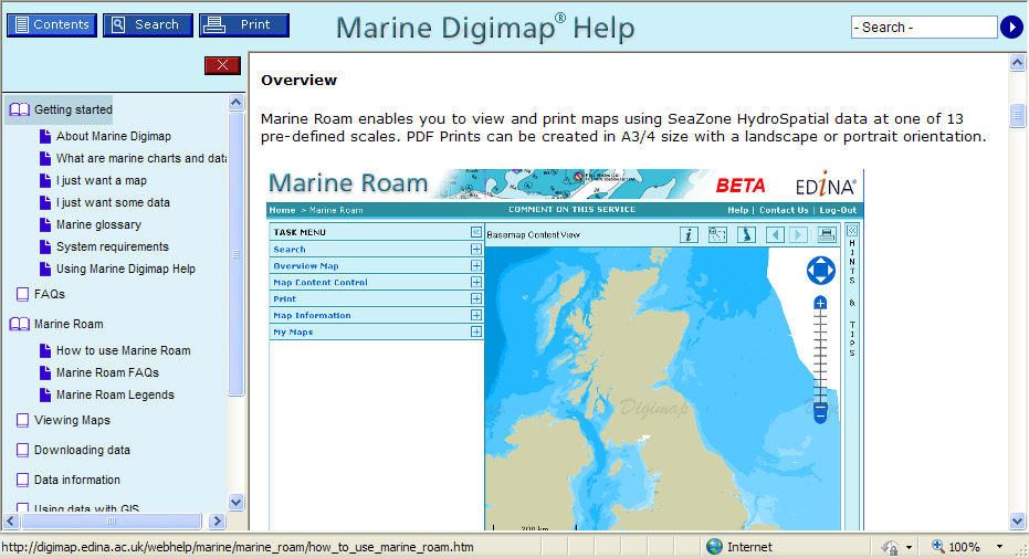
We are currently offering free trial access to the new Marine Roam facility to institutions which do not yet subscribe to Marine Digimap.
Marine Roam provides the only available online mapping tool for Hydrospatial data, a comprehensive dataset of features found in the marine environment, including buoys, wrecks, windfarms, sandbanks, flora and fauna, as well as transportation and socio-economic use information. Marine Roam is currently available as a beta service.
Any staff member at a UK Higher or Further Education Institution can request a free trial. EDINA will issue one username and password per institution which may be shared with anyone at that institution wishing to try the facility. Passwords will be valid until 31 March 2011.
Please feel free to pass this message to others who may be interested or request your trial account.
Information regarding how to subscribe to the Marine Digimap resource can be found at – http://edina.ac.uk/digimap/access/ a subscription provides access to data download facilities as well as online mapping.
We have implemented a new Help system for the Marine and Geology Digimap collections (Marine Help and Geology Help). The Help pages have been moved to a new production system which will make is easier for us to keep them more up to date and allow you to find the information you are looking for more easily and print better looking pages.
Visually there is not much change to the pages but over the coming months we will be updating and revising the content of the Help pages within Digimap to provide users with improved access to information about the Digimap facilities, the data available and how to use the data in different systems.
If you have any comments about the new Help pages or suggestions please let us know.
Tip: if you want to search for a phrase put it in quotes e.g. “zoom to position”
EDINA has receive a Highly Commended mention at the annual Association for Geographic Information (AGI) Awards for Innovation and Best Practice. http://www.agi.org.uk/agi-awards/
EDINA was entered in the Innovation and Best Practice (Charitable Status) category based on the presentation given at GeoCommunity 2010 by Tim Riley. Tim presented a paper entitled Digimap: 10 Years Old and yet Brand New. The migration of an established service to new GIS infrastructure. This described how much of the infrastructure of Digimap had been updated to a mainly Open Source solution which significantly improved the quality of service offered by Digimap. You can download Tim’s paper here: http://assgeoinf.squarespace.com/storage/geocommunity/papers/TimRiley.pdf
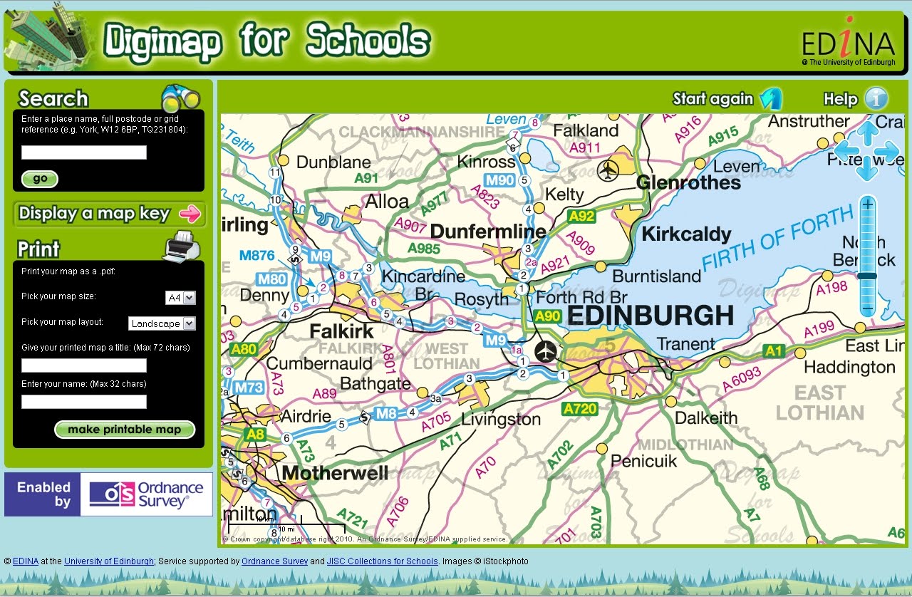
Baroness Joan Hanham CBE, Parliamentary Under Secretary of State for Communities and Local Government (CLG) has launched a brand new service to help improve the teaching of geography in schools with Dr Vanessa Lawrence CB, Director General and Chief Executive of national mapping agency Ordnance Survey. The launch took place at Graveney School in Wandsworth, London on Wednesday 10 November at 2pm.
Ordnance Survey is increasing its support for the teaching of geography at all levels by launching a brand new online mapping service for all schools across Great Britain. ‘Digimap for Schools’ provides schools with easy access to Ordnance Survey’s most detailed digital mapping for the whole of Great Britain. For the first time, pupils will have access to maps showing individual building outlines as well as familiar scales of mapping used by outdoor enthusiasts and on websites.
EDINA is pleased to announce the release of Digimap OpenStream – a web service delivering OS OpenData to the UK academic sector using open standard WMS technology.
Digimap OpenStream is an EDINA Digimap value-added service freely available to the academic community. Access is not restricted to registered Digimap users, although a one-off online registration is required. The OS OpenData offered is accessible 24/7 and users are able to embed it into their own application software without the overheads of downloading and managing large quantities of data.
Digimap OpenStream provides access to the following OS OpenData products:
MiniScale®
1:250,000 Scale Colour Raster
OS Vector Map™ District (Raster)
OS Street View®
Details of the Application Programming Interface (API) are provided along with simple guides illustrating how to use the service within popular GIS software.
Head of Research and Geo Data Services £46,510 – £52,347
Open-ended Contract
We seek a recognised leader in Geographic Information to sustain, develop and advance our strategic contribution to research and education in the UK. Use your experience in the use of geo-data, and proven record of research and team-working, to deliver online services and take forward project work at EDINA.
Based in Information Services at The University of Edinburgh, EDINA has world-class reputation for its service delivery and project success, in geographic information and more widely, http://edina.ed.ac.uk/. As a UK National Academic Data Centre, designated by the JISC, EDINA serves the needs of staff and students in universities and colleges across the UK, and is called upon to meet needs in the policy research and the school sectors – examples include support for INSPIRE and the recently-launched Digimap for Schools.
For further details about the post and to apply, please visit www.jobs.ed.ac.uk Job Ref Number: 3013235
EDINA has released Geology Roam; a new mapping facility within the Geology Digimap Collection. Geology Roam is based upon the Roam mapping facility from Digimap’s OS Collection and includes standard features such as fixed scale map views, ‘slippy maps’, map content customisation, searching by place name, postcode and grid reference, bookmarking and comprehensive help.
Geology Roam contains BGS DiGMap-625, DiGMap-250 and DiGMap-50 geology datasets and Ordnance Survey backdrop mapping. The geological data includes bedrock, superficial deposits, mass movement and faults.
Key features of Geology Roam include the ability to decrease/increase the opacity of the geology data over the Ordnance Survey back-drop map. A single click on the map will query the geology data and display details about the bedrock and any superficial deposits found at that point.
Geology Roam features a new printing interface that will become standard in all the Roam mapping facilities across Digimap. The new printing interface enables you to resize and reposition the map, and to add a map title and National Grid lines.
Beta Service
Currently available as a BETA service, we encourage you to give us feedback on the usability of Geology Roam so that issues you raise can be factored into ongoing development over the coming months. As well as responding to any issues you report, the following additional functions will be introduced:
Geological area (polygon) highlighting when clicking to obtain feature information, to make it easier to identify the extent of any geological feature to which the reported information corresponds.
Map based links to a Geology Photography Collection (JIDI Images). Icons will appear over the geology maps to indicate the availability of geological feature photographs for that location. Click on the icon to view these photographic images within the Geology Roam application.
Introduction of the BGS Rock Lexicon as an Independent application Geology Roam will run in parallel with the existing Geology Mapper during the Beta phase, after which Geology Mapper will be withdrawn (Dec 2010).
The existing mapping application will be withdrawn in December 2010 and will be wholly replaced by Geology Roam.
EDINA would welcome feedback on the service and on these proposed developments. Please contact us on edina@ed.ac.uk or 0131 650 3302.