Digimap and ShareGeo Open Break Usage Records

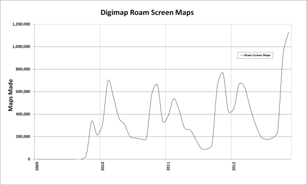
November was a record month for the Digimap Service with over 2 million screen maps made by the four collections. Digimap Roam made over 1 million screen maps alone and also broke its record for the number of print maps generated, over 28,000.

Digimap Roam Screen Maps to November 2012

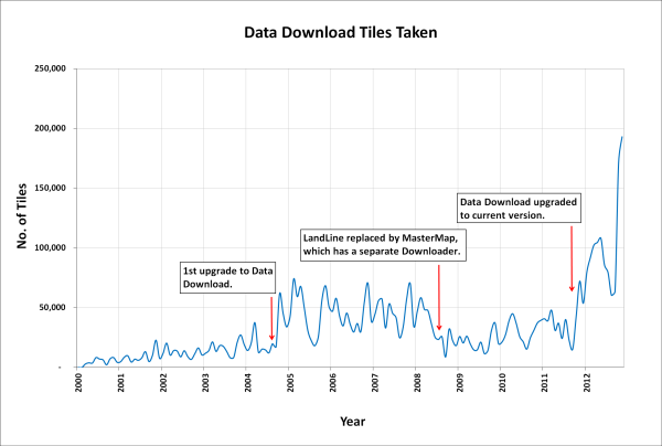
The number of files downloaded was also a record for Digimap with nearly 250,000 map tiles or files taken from the four collections. The Data Download facility for the Ordnance Survey Collection provided the bulk of these, over 190,000. Since the introduction of the new Data Download there has been a great deal more data supplied to staff and students but October and November have seen a huge spike.  This has also been achieved from a lower total number of orders showing how the changes made in the upgrade have greatly improved the efficiency of the process. It is now much easier to get all the data you need in a smaller number of orders.

Tiles Downloaded from Data Download, January 2000 to November 2012

On top of the downloads from the Digimap Collections, ShareGeo Open also had a record month. ShareGeo Open is a repository for open spatial data that promotes the sharing and re-use of spatial data in teaching and learning.

There were over 3400 downloads of datasets from the service, nearly double last November’s total. There are almost 200 different datasets available from the service, with the recent addition of wind farm locations for the UK proving popular. The most downloaded dataset for the past 6 months is the Postcode Areas file, made from the Code-Point Open data.

ShareGeo for Sharing Data

Have you created geospatial data for your research project or teaching module?
If so, why not put it in ShareGeo and share it with other Digimap users?

ShareGeo is a facility in Digimap where users can share and re-use geospatial data, whether they have been derived from exiting Digimap data or created entirely from scratch.

Why should I put my data in ShareGeo?

  • increase the visibility of your research
  • share datasets easily with colleagues and peers
  • create a record of your data with simple metadata
  • manage your data for future use

Also, you will:

  • find datasets you may be interested in
  • save time by re-using existing data that others have created

What’s new in ShareGeo?

New datasets available in ShareGeo include: UK Digital Terrain Model (DEM), UK National Parks boundaries, Government Office Regions, Strategic Health Authority boundaries and many others.

A full list of all datasets in ShareGeo can be found here.

How do I access ShareGeo?

ShareGeo can be accessed by logging in to Digimap and following the link on the Collections page to ShareGeo. http://edina.ac.uk/digimap/

More information about ShareGeo can be found at: http://edina.ac.uk/projects/sharegeo/index.shtml

Let us know what you think about ShareGeo by sending an email to: mailto:edina@ed.ac.uk?subject=ShareGeo

ShareGeo Launched

A new geospatial data sharing facility has been released today which enables Digmap users to find and share geospatial datasets.

ShareGeo forms part of the EDINA Digimap suite of services and is accessible from the Digimap Collections main page in the ‘Find and Share’ section. It is free for all Digimap users to use.


Use ShareGeo to contribute your own (derived or user-generated) geospatial datasets, or to download datasets which are already there for your research, teaching or personal use.

Have you created a geospatial dataset for your dissertation? Do you use them in your teaching? Do you think they would be interesting/useful to others? If so, contribute them to ShareGeo and they will be accessible for download by other Digimap users*.

Geospatial datasets in a number of formats (raster, vector and tabular) can be contributed for anywhere in the world. A minimal amount of metadata is required for each dataset. Access ShareGeo by logging in to Digimap (http://edina.ac.uk/digimap) and then either follow the link on the Collections page to ShareGeo or click on the following link: http://digimap.edina.ac.uk/sharegeo/

Help and further information is available at: http://edina.ac.uk/projects/sharegeo/Help/help.shtml We would welcome comments and feedback sent to us at edina@ed.ac.uk Alternatively you can use the form within ShareGeo at: http://digimap.edina.ac.uk/sharegeo/feedback

*Licensing restrictions may apply to some datasets. If, for example, a dataset is derived from Ordnance Survey data, only Digimap users registered for Digimap’s Ordnance Survey Collection will be able to access it. Specific licence restrictions may apply to individual datasets and these must be adhered to.

NEW! Geospatial data sharing service

EDINA have implemented a new geospatial data sharing facility called ShareGeo. It forms part of the Digimap Collections suite of services.


It is intended that ShareGeo will be accessible to all Digimap users at the beginning of February, however we are providing early access to it for readers of the Digimap blog (details of how to access it are below).

Please feel free to browse and download any datasets that are already there. If you have any geospatial datasets, we would ask you to contribute these to ShareGeo. ShareGeo is free to use for all registered Digimap users.

ShareGeo can be accessed after logging in to Digimap, using the following liks.

  • First login to Digimap at: http://edina.ac.uk/digimap You will see a greyed out link to ShareGeo.
  • The visible link is not active, so you will need to go to ShareGeo by entering the following link in your browser: http://digimap.edina.ac.uk/sharegeo/ (Note: Once the facility is accessible to all, there will be a link on the Digimap Collections page to take you directly to ShareGeo)

Help and further information is available at: http://edina.ac.uk/projects/sharegeo/Help/help.shtml We would welcome comments and feedback sent to us at edina@ed.ac.uk Alternatively you can use the form within ShareGeo at: http://digimap.edina.ac.uk/sharegeo/feedback

If you need help or advice regading ShareGeo please do not hesitate to contact us.