Any views expressed within media held on this service are those of the contributors, should not be taken as approved or endorsed by the University, and do not necessarily reflect the views of the University in respect of any particular issue.
Digimap is an online map and data delivery service, available by subscription to UK Higher and Further Education establishments. Operated by EDINA at the University of Edinburgh, Digimap offers a number of data collections, including Ordnance Survey, historical, geological, aerial photography, LiDAR, marine maps, land cover mapping, global mapping and census data. For more information about Digimap go to our website: https://digimap.edina.ac.uk Background image Contains OS data (c) Crown Copyright and database right 2022
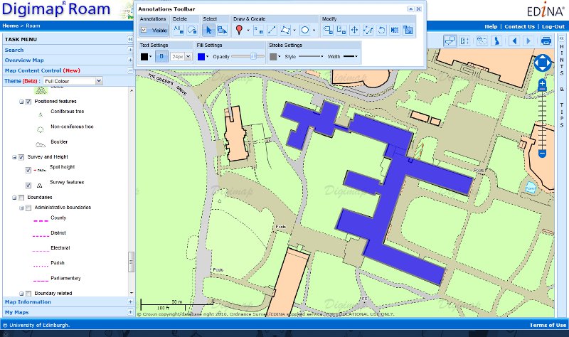
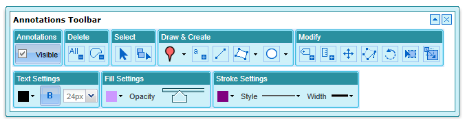
Ancient Roam now has the annotation tools, so all the Roam facilities allow you to add your own features (symbols, lines, polygons and text) to the map.
We are always looking for feedback so if you have any requests for symbols, line styles or any other features you would like put on the map, let us know. You can comment on this post or email us directly here:
The 2011 Esri UK and Eduserv Seminar will be taking place on 13th September at Surgeons Hall in Edinburgh. The event is a chance for Esri users from UK Academia to hear about the new Esri CHEST agreement which started on 1st August, as well as what’s coming in ArcGIS 10.1 and various presentations from members of the Higher Education community. Members of the Digimap team will be attending to present on using Digimap data in ArcGIS, we will also have a stand so if you are attending, come and talk to us!
Digimap OpenStream, EDINA’s open WMS service, has been updated with the latest version of OS Street View from the OS OpenData collection. The latest version is from May 2011 and contains change-only updates.
EDINA aims to provide the latest version of OS OpenData via the OpenStream service. This means that datasets may be updated part way through an academic year.
For more information about OpenStream and to register click on the following link:
Ordnance Survey isn’t the national mapping agency for the Isle of Man, however they do include it in a few of the mapping products they produce:
OS MiniScale,
1:250,000 Scale Colour Raster
Strategi,
Land-Form PANORAMA,
1:50,000 Scale Colour Raster
The easiest way to view the Isle of Man is to do a place name search for Douglas or anywhere else on the island in Digimap Roam. This will take you straight to the Local View, which uses the 1:50,000 Scale Colour Raster. You can zoom out from this view and see maps at each scale level, though there are only contours in the District View as there is no Meridian 2 data to provide roads and other topography.
Unfortunately you cannot zoom in from the Local View as this is the most detailed mapping the Ordnance Survey have for the Isle of Man. If you need more detail then you will have to contact the Isle of Man Government:
As lots of people are currently working on projects and dissertations we thought we’d share a few tips on using the OS MasterMap data from Digimap.
NOTE: MasterMap Download will be temporarily unavailable as part of the ‘At Risk’ period on Monday the 22nd of August. It will also be unavailable for about an hour on either Wednesday 24th or Thursday the 25th of August as well. This is to allow for some essential hardware maintenance on the server that houses the Database. We are really sorry for any inconvenience this causes.
The MasterMap data available will be updated as part of our annual data refresh at the beginning of September. If you need the 2010-2011s data then please order in advance of Monday the 22nd to ensure you don’t get caught up with the maintenance.
Downloading the Data
Remember that if you just want MasterMap as a background map you can use the 1:1000 or 1:2000 Raster versions of the data. This is available from the Data Download facility:
Once you have downloaded your MasterMap Data you will most likely need to convert it into a format that your GIS can use. There are three main options to do this, InterpOSe, OSM2MIF and Productivity Suite, see the following link for more information:
This year’s annual data update will take place at the beginning of September. There will be a refresh the following Ordnance Survey products:
MasterMap Topography and ITN Layers
VectorMap Local
Meridian2
Strategi
MiniScale
Code-Point
Code-Point with Polygons
Boundary Line
1:250,000 Colour Raster
1:50 000 Colour Raster
1:25 000 Colour Raster
1:10 000 Raster
1:50 000 Scale Gazetteer
There will also be updated Hydrospatial data in Marine Digimap and a new version of the DiGMapGB-50 data in Geology Digimap.
Along with the new data Ancient Roam will be getting the Annotation Tools and there may be a bit of a surprise bonus addition to Digimap Roam. More information will be posted on the Blog, Twitter and Facebook page nearer the time.
Now we have the annotation tools up and running they are being added to all the Roam services thick and fast! Marine Roam is the latest to get the tools, again they are an initial version with the basic set of features.
Please let us know if you have any requests for symbols, line styles or any other features you would like to be able to annotate the map with. You can comment on this post or email us directly here:
Following on from the success of the annotation tools in Digimap Roam, we have now added them to Geology Roam. The tools are the same as the one in Digimap Roam at the moment but we hope to add in a set of geology specific symbols and features in the near future.
We’d like to know what sort of annotations you’d like to put on the geology maps; perhaps a dip and strike symbol you can rotate and add a dip value to, or a borehole symbol that you can label with a depth and ID number. Please comment on this article if you have any ideas or send us an email:
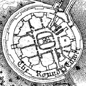
You can now download high quality PDF maps from Ancient Roam for printing. This element of the service has been quite tricky to implement, so until now we have only had the save image button to get a PNG image of the map you are viewing.
Now you can use the print button to access a similar interface to the ones found in all the other Roam services. You can see a sample PDF by clicking on the thumbnail below:
A Sample PDF from Ancient Roam.
There are still a couple of options to add into Ancient Roam print maps; we need to add the ability to print 2up maps and the ability to switch off counties in areas where there are overlapping maps. Look out for these arriving in the near future.
Information about how to use all the features of Ancient Roam can be found on the following help page: