Training Reminder: Manchester and Nottingham

EDINA would like to remind you that booking is now open and there are spaces available on the following Digimap training courses, which are open to staff members in UK higher and further education institutions:

University of Manchester:

  • Guidance for site reps: 9 March 2010
  • Making maps in Digimap Collections: 10 March 2010
  • Downloading data from Digimap Collections 11 March 2010

Bilborough College, Nottingham:

  • Guidance for site reps: 7 April 2010
  • Making maps in Digimap Collections: 8 April 2010
  • Downloading data from Digimap Collections: 9 April 2010

You will find more details of course content and booking forms on EDINA’s Training and Events page . If you are uncertain about the relevance of a course for your needs, please contact EDINA for advice at edina@ed.ac.uk.

Changes to Digimap on 26 January

Yesterday, Tuesday 26 January 2010, some changes were made to Digimap. These are detailed as follows:

1. Classic removed from Ordnance Survey Collection.
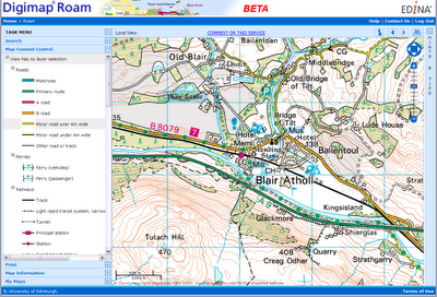
As advertised on 5 October 2009 and 6 January 2010 this old facility has been removed and replaced by the new Roam facility. You can find a demonstration of Roam on the EDINA website: Roam demonstration

2. Historic Digimap “preview map sheet” button has been removed.
This function used out-of-date technology to render the original historical map sheets in the browser window. It was extremely slow and was dependent upon software installed on a machine which is being decommissioned. It is much quicker and more user-friendly to download the map sheet required and view it locally.

3. Marine Digimap Hydrospatial data updated.
The 2009 version of SeaZone’s Hydrospatial data is now available through Hydrospatial Download. Late delivery of the data has meant a delay of the release from September 2009 to January 2010.

MapAction – Haiti Appeal

MapAction is a a volunteer-based charity and non-governmental organisation which works in disaster zones providing frequently updated situation maps showing where relief help is most urgently needed.

The earthquake in Haiti has killed all but two members of the Haitian national mapping agency (the equivalent of Ordnance Survey). At Digimap’s 10th Anniversary event on 20th January 2010, Vanessa Lawrence, Ordnance Survey’s Chief Executive and Director General, took a moment to tell of the work that MapAction are doing in Haiti and encouraged donations to this cause.

Donations can be made online directly from the MapAction website: http://mapaction.org/.


ArcGIS and raster catalogs

The following may be of interest to those Digimap users who have ArcGIS 9.3.1 and are using raster catalogs.

ESRI have just released a patch fixing the issue with Microsoft SQL Server and Raster Catalogues. This works with ArcGIS 9.3.1 Service Pack 1.

ESRI’s announcement is as follows:

“ESRI announces ArcSDE 9.3.1 SP1 SQL Server Raster Catalog and Raster Field Patch. This patch addresses the raster catalog display and raster field identify problem for SQL Server following the install of 9.3.1 sp1. We recommend that all who store raster catalogs or raster fields in ArcSDE for SQL Server download and install this Patch at their earliest convenience to ensure the highest quality experience when working with ArcSDE 9.3.1 Service Pack 1.”

Link to patch🙁http://support.esri.com/index.cfm?fa=downloads.patchesServicePacks.viewPatch&PID=17&MetaID=1586)

Not getting emails?

We have recently noticed that some Hotmail accounts are rejecting emails from edina@ed.ac.uk as spam. This also includes emails which have been automatically forwarded to a Hotmail account from an institutional email account (.ac.uk).

This means that some users may not receive emails from which to download OS MasterMap data or their “Welcome to Digimap” registration confirmation.

If you believe you are not receiving emails from EDINA, please check that you have edina@ed.ac.uk in your Hotmail list of Safe Senders.

Training: Southampton, 1 February

EDINA will be running a Digimap training course entitled “What to do with Digimap data” on Monday 1 February at Southampton University.

Further details of this course can be found on the EDINA website.

Please register by 17 January 2010 if you would like to attend. The course is free and lunch/refreshments will be provided.

If you have any questions about who should attend or about the course content, please contact the EDINA Helpdesk on edina@ed.ac.uk or 0131 650 33302.

Digimap Classic Removal

On 26 January, the Digimap Classic mapping facility available in the OS Collection will be removed and will no longer be available for use. NOTE: ALL OTHER DIGIMAP FACILITIES WILL REMAIN AS THEY ARE.

Any maps present in your Classic Map Chest on 26 January will be lost. Please ensure that you print or save any maps that you require before 26 January. Please contact the EDINA Helpdesk (edina@ed.ac.uk) if you require any assistance in saving or printing maps from Classic.

The new Roam facility (released in October 2009) replaces Classic as the standard mapping facility in Digimap OS Collection. Key features of Roam include: 12 fixed scale map views, click-and-drag navigation or “slippy maps” and enhanced printing options enabling you to generate printable PDF maps in landscape or portrait and A4 or A3 size. Roam is a significant improvement on Classic, providing many enhanced futures and an easier to use, more intuitive user interface.


Digimap 10th Anniversary Celebration

EDINA is holding a celebratory event to mark the 10th anniversary of the launch of the Digimap service on the 20th January 2010. All Digimap site reps and support staff are invited to join us in Edinburgh to mark the occasion.

During the day, there will be a number of speakers and demonstrations to showcase the Digimap service past, present and future and in the evening there will be a drinks reception followed by dinner with guest speaker, Mike Parker (television presenter and author of ‘Map Addict’).

The daytime event will be free of charge with lunch and refreshments provided. Tickets for the evening event (including drinks reception) will be available for £24 (or £30 including wine).

Site reps and Support staff can find out more details and register for the event here:

Event Programme

#digimap10

Live Webinar: Productivity Suite

ESRI (UK) is running a LIVE WEBINAR entitled:

Productivity Suite 2.0 – Unlocking the Full Potential of Ordnance Survey Data

It is being held on Wednesday 4 November 2009, 10:00 – 11:00 am

If you are using Ordnance Survey data from Digimap and your institution has a licence to use ArcGIS, you might find this a useful event to attend. Licensing ArcGIS via Chest includes the Productivity Suite, an additional software application providing data conversion tools. Productivity Suite does not cost extra, but should be requested specifically when the Chest licence is purchased.

Further details of the Webinar can be found on the ESRI (UK) website at: http://www.esriuk.com/trainingevents/events/productivitysuite041109/

A further note on creating EPS files…

You can create EPS files directly from Adobe Acrobat by using an appropriate Printer Driver e.g. CutePDF or one downloaded from Adobe’s website. For example: http://www.adobe.com/support/downloads/detail.jsp?ftpID=1500 and follow the instructions at: http://www.ep.ph.bham.ac.uk/general/printing/winsetup.html

Note: you will need the Generic Colour Postscript PPD file linked in the document if you want to print A3 or larger. You can download the PDD file from the above website.

Load the PDF into Acrobat and then go to File ->Print. Select CutePDF Writer (or another Postscript printer you have installed). Click on Properties and then the Advanced… button.

There is a section called Postscript Options; expand this to find the PostScript Output Option and change this from ‘Optimize for Speed’ to ‘Encapsulated Postscript (EPS)’.

When you print you will now be asked to save a file which you should add the extension .eps to your file. You should be able to open this file in Ghostview as a vector EPS.