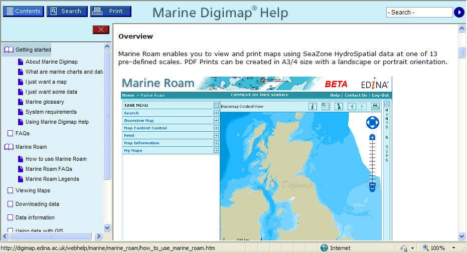
In lieu of EPS files…

Since Digimap ceased to generate EPS files we have had a number of enquiries about suitable alternatives. Currently, Digimap’s mapping facilities will only produce PDF files. However, there are a number of options for those who prefer to use other formats. The following notes may help.

Note that EDINA does not endorse or recommend any of the products or services detailed here or guarantee their quality or performance.

PDF files generated from Digimap can be converted to various other formats including PNG, SVG, and PS/EPS using free software called Inkscape (http://www.inkscape.org/). The only down side to this that we have found is that it seems to blur the PS/EPS because of the ‘Digimap’ watermark.

You can also edit the vectors in Inkscape. If you want to put the map (or a bit of it) into a Word document there is a nifty little command in Acrobat under Tools –> Select & Zoom–> Snapshot Tool which allows you to define an area and then paste it into Word (or another programme) – note this is lower resolution than you can create with Inkscape.

The PDFs themselves can be opened in CS3 Adobe Illustrator as editable vector graphics and then exported to various formats. The PDFs can also be opened and converted to EPS in GhostView but this seems to treat them as images rather than vectors.

There are various software packages that will convert from vector PDF to DXF (e.g. http://www.trixsystems.com/pdfFLY.html) but we have not found any which are free of charge.

If DXF/DWG is required for OS MasterMap, the best option is to download GML and use Dotted Eyes’ InterpOSe software to convert from GML to DXF/DWG.

Roam – new mapping tool available

Today, Monday 5 October, a new mapping tool is available to all registered users, through Digimap’s Ordnance Survey Collection.

Roam, the new mapping facility, is available as a BETA service and will therefore be subject to various improvements over the next few months. Planned changes include:
– additional print formats as alternatives to PDF
– inclusion of scalebar on printed maps
– provision of scale and extent indication on screen maps
– adding a “My Maps” function for bookmarking maps

Roam offers “click and drag” functions to locate your map, 12 map views at different scales, printing in PDF at both A3 and A4 sizes, search by place name, postcode or grid reference, seamless scrolling through the fixed scale maps and 5 customisable map views. You can access Roam from the icon above Classic in Digimap’s Ordnance Survey Collection home page.

We hope you will use the new facility and let us know what you think of it. There is a link within Roam for you to report any feedback you have (positive and negative). You can also email us on edina@ed.ac.uk or telephone us on 0131 650 3302.

Roam will replace the current Classic facility in January 2010.

New Digimap Training Schedule 2009-10

Booking is now open for several Digimap training courses and online workshops to be run in 2009-10. These events are open to staff members in UK higher and further education institutions.

Further details of course content and learning objectives can be found on our website, where you will also find booking forms: http://edina.ac.uk/events/

The first online workshop, Digimap Site Reps – Update for 09/10, is scheduled for 7 October 2009 at 12:00 noon. Emma Sutton will discuss the Variation Agreement to the Ordnance Survey Data sub-licence, which took effect in August 2009. The recent data update will also be covered.

Lunch and refreshments are provided for attendees. All EDINA training courses are free of charge. Regretfully, however, we will charge £25.00 per person for each day of absence of which EDINA is not given prior notice.

If you are uncertain about the relevance of a course for your needs, please get in touch with EDINA for advice at edina@ed.ac.uk.

MasterMap Download: availability update

Following an unscheduled outage over the past 24 hours, MasterMap Download is now available again.

However, Topographic Layer orders are limited to 25sq.km and all orders may take longer than the advertised 2 days to process. Please be patient and do not resubmit your order.

We aim to restore full service early next week. Further information will be posted here when available. Apologies for the inconvenience.

MasterMap Download unavailable

Following some unsuccessful remedial work carried out on the database this morning, MasterMap Download continues to be unavailable.

At this time we do not know when the service might be restored. Engineers are working towards this, but a time estimate is not yet available.

Further information will be posted here when available. Apologies for the inconvenience caused.

MasterMap Download now available

Following this afternoon’s diagnostics test, MasterMap Download is now available but running under reduced capacity. Orders for Topography Layer are limited to 5 x 5 km (25 sq. km) as a temporary measure.

Between 07.30 and 09.30 hrs on Thursday 24 September, MasterMap Download will be unavailable to allow a fix to be applied. Further information on its success will be available thereafter.

Apologies for the inconvenience caused.

MasterMap Download temporarily withdrawn: 23.9.09

The MasterMap Download facility will be temporarily withdrawn at 14.00 hours today, Wednesday 23 September 2009.

Currently, significant software faults are causing most data orders to fail and the system is unstable. Withdrawing access will allow EDINA to undertake diagnostic work to identify a solution to the problem. External software suppliers are also involved.

As yet, we do not know how long the service will need to be unavailable, but futher information will be posted here and on the Digimap login page, as and when it is available.

Should you have an urgent data order, please contact the EDINA Helpdesk with details of the data you require. We cannot process orders immediately, but we may still have an opportunity to meet the advertised 2-day delivery schedule. This very much depends on the problem identified.

EDINA apologises for any inconvenience caused.

2009 Annual Data Update

New data
On Thursday 17th September EDINA released all available updates for data provided through Digimap’s Ordnance Survey Collection. Details of the versions of all the data offered can be found on the EDINA website here. The Digimap licence also now offers MiniScale and the OS 1:250,000 scale colour raster data. These are currently available through ShareGeo and will be added to the Data Download as soon as possible.

Architectural Changes

As well as updating the data, other significant changes have been made to the underlying technologies supporting Digimap. In short, we have replaced the entire GIS architecture which produces the maps you see online.

The new software, from Cadcorp, offers a number of benefits to both EDINA and end users of Digimap. As well as enhanced quality maps and faster map generation online, the printed output gives crisp, clear maps as PDF files. EPS files are no longer available from any facility within Digimap’s OS Collection, including Carto, but EDINA is working on the provision of additional formats to PDF.

New mapping facility: Roam

With the arrival of the new GIS software, EDINA has also developed a new mapping facility, called Roam. Still in a development phase, Roam offers the usual search functions as well as “slippy maps”, the click-and-drag function used to position a map, familiar to users of other popular online mapping facilities. It is easier to locate your map, easier to zoom in and out, and now offers maps at 12 different fixed scales. An additional small scale Ordnance Survey mapping product, MiniScale, has been included, and other datasets (e.g. Strategi and OS MasterMap) are available at more than one fixed scale.

Currently Roam is available as a Beta facility to site representatives only until Monday 5th October, when it will become available to all registered users of Digimap’s Ordnance Survey Collection. Roam is available from the OS Collection Home page; you will find the new icon next to those for Classic and Carto. It will be greyed out if you don’t yet have access to it.

Roam will run in Beta alongside the current Classic facility until January 2010 when Classic will be withdrawn entirely. Regular updates will be made to Roam to add new functionality, such as MyMaps, prior to its release as a full service in January 2010.

If you have any questions about this email or about Digimap in general, please do not hesitate to contact the EDINA Helpdesk on edina@ed.ac.uk

Reminder: OS Collection Licence Renewal

Remember that you need to renew your institution’s subscription to Digimap’s Ordnance Survey Collection BEFORE 30 September 2009 in order to ensure continuity of service.

If your institution has not completed and returned the appropriate licensing forms by this date, access to Digimap’s Ordnance Survey Collection will be removed.

Owing to the way access is controlled under the UK Federation there will be no exceptions to and no leeway given for this date. If you have already requested an invoice, you still need to return the subscription forms to the address supplied on the forms by 30 September 2009.

Should you have any questions please contact either JISC’s Subscription Agent (subscriptionshelp@jisc.ac.uk) or the EDINA Helpdesk (edina@ed.ac.uk)

CHEST / ESRI Technical Event – 15 Sep 2009

The following event may be of interest to Digimap users.

Following the success of the ESRI Technical Event held at the University of Leeds in 2008, Eduserv and ESRI have arranged a second meeting, to be held at the University of Birmingham on 15th September 2009. The meeting is intended to bring together people from universities and colleges who are either using ArcGIS (or other ESRI software) or providing and supporting ESRI software in their institutions. In addition to an overview of the new facilities in the latest version of ArcGIS, other topics include a visit to Birmingham University’s 3-D Visualisation Suite, a discussion of how to make the most of the ArcGIS licence management system and an introduction to ArcGIS in virtualised or server environments. There is also plenty of time to meet and talk with colleagues from other institutions and staff from ESRI UK.

Lunch will be provided and there is no charge for the event. However, you do need to register your interest in attending. You can do this online at MyESRIUK here:


Date: Tuesday 15 September 2009
Time: 10:00am tea and coffee for a 10:30am start
Location: University of Birmingham (specific details and map will be provided upon registration)

Timetable:

10:00am – tea and coffee

10:30am – ESRI Introduction: Angela Baker (ESRI UK)

10:50am – Virtualisation vs. ArcGIS Server: Peter Halls (University of York) and Alison Rumble (ESRI UK)

11.20am – User Experience Talk

12.00pm – 2.00pm – Lunch with time for networking as well as guided
tours of the Virtualisation Suite at University of Birmingham

2.00pm – Interoperable Landmap and EDINA data and services: Kamie Kitmitto (Mimas)

2:30pm – new features of ArcGIS 9.3.1 and extensions – demonstration by Alison
Rumble (ESRI UK)

3:00pm – Break for tea and coffee

3:30pm – Licensing Issues: Anna Clough (University of Leeds) and Peter
Halls (University of York).
Topics include: how to find out how many
users you really have and who those users are (flex logfile analysis);
non-dongled support; use outside of the British Isles; licence servers.

4:00pm – Question and Answer

4:30pm – Tea / Coffee to close.

For full details of the Chest Agreement for ESRI please visit www.eduserv.org.uk/ESRI

If you have any questions, please see the Eduserv website or contact Eduserv Help at help@eduserv.org.uk