Any views expressed within media held on this service are those of the contributors, should not be taken as approved or endorsed by the University, and do not necessarily reflect the views of the University in respect of any particular issue.
Digimap is an online map and data delivery service, available by subscription to UK Higher and Further Education establishments. Operated by EDINA at the University of Edinburgh, Digimap offers a number of data collections, including Ordnance Survey, historical, geological, aerial photography, LiDAR, marine maps, land cover mapping, global mapping and census data. For more information about Digimap go to our website: https://digimap.edina.ac.uk Background image Contains OS data (c) Crown Copyright and database right 2022
Digimap OpenStream, EDINA’s new open WMS service, was been updated with the latest version of MiniScale from the OS OpenData collection on 25 January 2011. The most significant changes to this dataset include improved ferry route labeling and a different representation of urban areas.
EDINA aims to provide the latest version of OS OpenData via the OpenStream service. This means that datasets may be updated part way through an academic year.
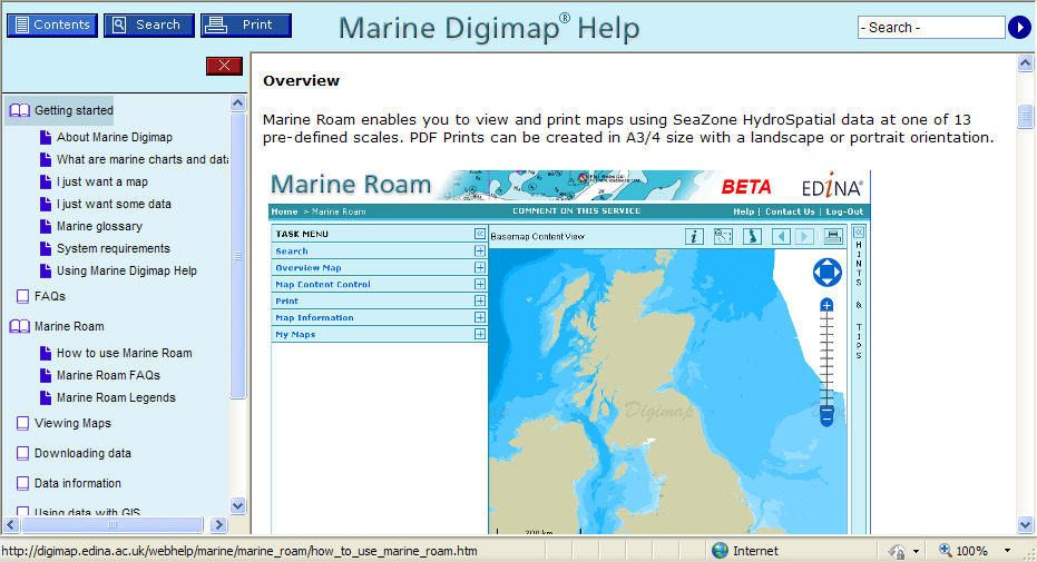
We have implemented a new Help system for the Marine and Geology Digimap collections (Marine Help and Geology Help). The Help pages have been moved to a new production system which will make is easier for us to keep them more up to date and allow you to find the information you are looking for more easily and print better looking pages.
Visually there is not much change to the pages but over the coming months we will be updating and revising the content of the Help pages within Digimap to provide users with improved access to information about the Digimap facilities, the data available and how to use the data in different systems.
If you have any comments about the new Help pages or suggestions please let us know.
Tip: if you want to search for a phrase put it in quotes e.g. “zoom to position”
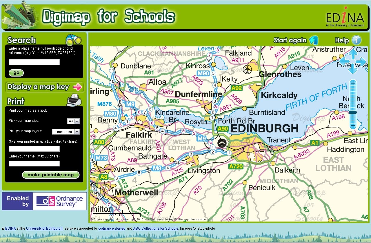
Baroness Joan Hanham CBE, Parliamentary Under Secretary of State for Communities and Local Government (CLG) has launched a brand new service to help improve the teaching of geography in schools with Dr Vanessa Lawrence CB, Director General and Chief Executive of national mapping agency Ordnance Survey. The launch took place at Graveney School in Wandsworth, London on Wednesday 10 November at 2pm.
Ordnance Survey is increasing its support for the teaching of geography at all levels by launching a brand new online mapping service for all schools across Great Britain. ‘Digimap for Schools’ provides schools with easy access to Ordnance Survey’s most detailed digital mapping for the whole of Great Britain. For the first time, pupils will have access to maps showing individual building outlines as well as familiar scales of mapping used by outdoor enthusiasts and on websites.
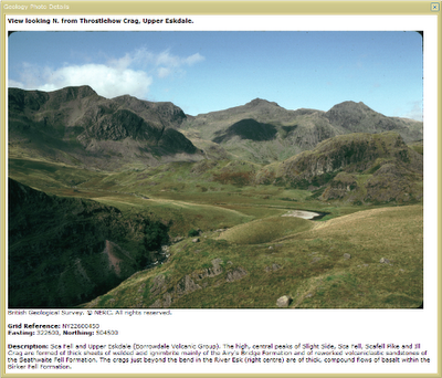
Geology Roam now allows you to view British Geological Survey images (of geological features, rocks, fossils and the BGS at work) from the JIDI Image Collection. The images area accessed via the map interface when you are zoomed in to the most detailed geology maps.
There are over 3000 images mainly found in geologically rich areas such as Cumbria, North and South Wales, the Dorset coast, Edinburgh etc. The images cover a wide range of features from details of bedding planes and large crystals in rock faces to aerial photographs of valleys showing glacial erosion features.
To access the photos go to one of the 5 most detailed zoom levels in Geology Roam and click on the camera icon in the tool bar or Geological Photos tab. You can then pan around the maps till you find an area with some photos.
The photos are marked on the map at the location they were taken from; click on the markers to see thumbnails of the image(s) for the location. You can view a full sized image with detail about what is shown by clicking on the thumbnail.
These photos are useful for geologists but there are also some spectacular landscape images that can be enjoyed by everyone.
EDINA is pleased to announce the release of Digimap OpenStream – a web service delivering OS OpenData to the UK academic sector using open standard WMS technology.
Digimap OpenStream is an EDINA Digimap value-added service freely available to the academic community. Access is not restricted to registered Digimap users, although a one-off online registration is required. The OS OpenData offered is accessible 24/7 and users are able to embed it into their own application software without the overheads of downloading and managing large quantities of data.
Digimap OpenStream provides access to the following OS OpenData products:
MiniScale®
1:250,000 Scale Colour Raster
OS Vector Map™ District (Raster)
OS Street View®
Details of the Application Programming Interface (API) are provided along with simple guides illustrating how to use the service within popular GIS software.
EDINA has released Geology Roam; a new mapping facility within the Geology Digimap Collection. Geology Roam is based upon the Roam mapping facility from Digimap’s OS Collection and includes standard features such as fixed scale map views, ‘slippy maps’, map content customisation, searching by place name, postcode and grid reference, bookmarking and comprehensive help.
Geology Roam contains BGS DiGMap-625, DiGMap-250 and DiGMap-50 geology datasets and Ordnance Survey backdrop mapping. The geological data includes bedrock, superficial deposits, mass movement and faults.
Key features of Geology Roam include the ability to decrease/increase the opacity of the geology data over the Ordnance Survey back-drop map. A single click on the map will query the geology data and display details about the bedrock and any superficial deposits found at that point.
Geology Roam features a new printing interface that will become standard in all the Roam mapping facilities across Digimap. The new printing interface enables you to resize and reposition the map, and to add a map title and National Grid lines.
Beta Service
Currently available as a BETA service, we encourage you to give us feedback on the usability of Geology Roam so that issues you raise can be factored into ongoing development over the coming months. As well as responding to any issues you report, the following additional functions will be introduced:
Geological area (polygon) highlighting when clicking to obtain feature information, to make it easier to identify the extent of any geological feature to which the reported information corresponds.
Map based links to a Geology Photography Collection (JIDI Images). Icons will appear over the geology maps to indicate the availability of geological feature photographs for that location. Click on the icon to view these photographic images within the Geology Roam application.
Introduction of the BGS Rock Lexicon as an Independent application Geology Roam will run in parallel with the existing Geology Mapper during the Beta phase, after which Geology Mapper will be withdrawn (Dec 2010).
The existing mapping application will be withdrawn in December 2010 and will be wholly replaced by Geology Roam.
EDINA would welcome feedback on the service and on these proposed developments. Please contact us on edina@ed.ac.uk or 0131 650 3302.
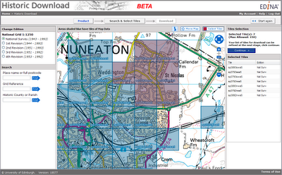
Launched as a BETA service on 20 April 2010, Historic Download is an entirely new facility allowing users to select and download larger quantities of historical map data.
The facility offers the capability to browse contemporary maps of the UK which have been shaded blue to indicate the coverage of historical maps of each series and edition. Areas of historical maps can be selected for download by clicking on the appropriate shaded polygons or by dragging a box to select multiple map sheets.
The interface has been designed to improve selection and retrieval of larger quantities of data for research projects. Build up a list of the data you need, choosing maps from different editions of a given product and take up to 200 maps in a single download.
EDINA welcomes feedback on this BETA service. You can contact us on edina@ed.ac.uk or 0131 650 3302.
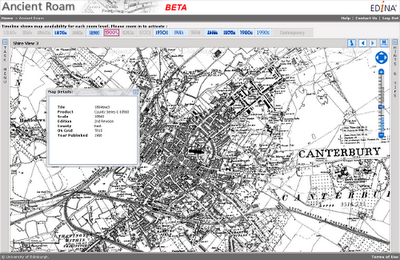
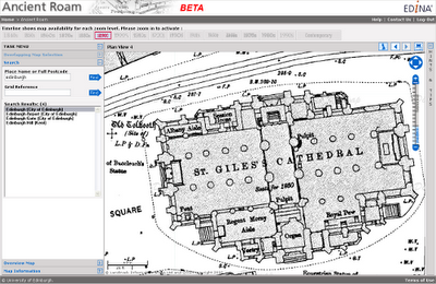
Ancient Roam is a new mapping facility within Historic Digimap. It is based upon the Roam mapping client available from Digimap’s OS Collection and includes the standard features such as fixed scale map views, ‘slippy maps’, searching by place name, postcode and grid reference, easy to use zooming and comprehensive help.
Key features specific to Ancient Roam include the ability to select historical maps from any decade (depending on map coverage and availability) using the Timeline along the top of the map window. Ancient Roam also offers an easier means of identifying and selecting maps in areas where County Series overlap at County boundaries. A single click on the map will also query maps to display the year the map shown was published along with other information about the map.
New Town Plan Maps
The large scale Town Plans are now available to view in Ancient Roam and download from Historic Download. The Town Plans are the largest scale historical maps available from Digimap offering great detail at 1:500, 1:528 and 1:1056 scales. The coverage of these maps is limited in that only settlements with a population greater than 4000 at the time of surveying were mapped. It is interesting to see what were regarded, then, as “urban” areas. The detail captured is enlightening; individual trees are marked in parkland and many industrial and commercial uses of land and buildings are noted.
Beta Service
Currently available as a BETA service, Ancient Roam will continue to undergo development over the coming weeks. Proposed additional functions include:
PDF map creation for printing
My Maps, to enable bookmarking screen maps for future reference
Multiple historical map views, to enable comparison of maps of different dates
Map fade slider, to show transition between maps of different dates
The ability to download the original Map sheet data which makes up your current on-screen map view
EDINA would welcome feedback on the service and on these proposed developments. Please contact us on edina@ed.ac.uk or 0131 650 3302
EDINA welcomes the release of Ordnance Survey datasets for free use and re-use. We are actively working to realise to the full the opportunities offered by this new policy for the enhancement and development of new and existing services for research and education.
As many will already know the Government published details on 31 March 2010 of the package of datasets and products from Ordnance Survey that are now available under OS OpenData – see http://www.ordnancesurvey.co.uk/oswebsite/opendata/. The list coincides partially with the datasets currently available through EDINA Digimap – see below. Note especially that OS MasterMap, the large-scale vector data, is only available through registration with EDINA Digimap.
The key task for EDINA Digimap is to provide ease and continuity of access to a whole range of geo-spatial datasets, including re-use in materials that are shared in research and teaching. We are therefore seeking clarification from Ordnance Survey regarding the licence terms that can now apply to the data available through Digimap which are now covered under OS OpenData.
The release of many Ordnance Survey datasets as open data is also good news for Unlock, the EDINA service which is there to help you geo-enable research data and other Internet-accessible documents and images. Unlock, and its predecessor GeoCrossWalk, were previously limited by license to academic use only. Relevant datasets now regarded as open data, including Boundary-Line, Code-Point® Open and the 1:50 000 gazetteer of place names, can now be used by Unlock Places, Unlock Text and Unlock Geocodes.
We are keen to learn from users of Digimap how you wish us to take best advantage of these changes in availability and licensing. Contact us by email on edina@ed.ac.uk or leave a comment on this blog.
Product Name
EDINA Digimap
OS OpenData
OS MasterMap Topography
Yes
No
OS MasterMap ITN
Yes
No
1:10 000 Scale Raster
Yes
No
nearest equivalent is OS StreetView
1:25 000 Scale Colour Raster
Yes
No
1:50 000 Scale Colour Raster
Yes
No
1:250 000 Scale Colour Raster
Yes
Yes
MiniScale®
Yes
Yes
Meridian™2
Yes
Yes
Strategi®
Yes
Yes
Land-Form PANORAMA® Contours
Yes
Yes
Land-Form PANORAMA® DTM
Yes
No
Land-Form PROFILE®
Yes
No
Boundary-Line®
Yes
Yes
Code-Point®
Yes
No
CodePoint® with Polygons
Yes
No
Code-Point® Open
(point data only; subset of Code-Point®)
MiniScale and 1:250 000 Raster data are now available in Digimap’s Ordnance Survey Collection Data Download facility.
The datasets have been available from the ShareGeo service for some time, but are now also available from within Digimap. In addition to the new products you can now also:
download the OS Land-Form PROFILE, 1:10 000 Contour data in DXF format
download Shapefile and MID/MIF versions of Meridian2 data
The new Meridian2 formats have their own entry on the Product & Format page of Data Download. These formats are available as national coverage, with a single download covering the whole of Great Britain. The NTF and DXF formats are still available as individual tiles.
Land-Line style maps available in Carto
Maps of OS MasterMap data in Carto can now be styled to look like previous Land-Line.Plus maps. This is particularly useful for black and white printing or to recreate Land-Line.Plus data for comparison with older printed maps.