Any views expressed within media held on this service are those of the contributors, should not be taken as approved or endorsed by the University, and do not necessarily reflect the views of the University in respect of any particular issue.
Digimap is an online map and data delivery service, available by subscription to UK Higher and Further Education establishments. Operated by EDINA at the University of Edinburgh, Digimap offers a number of data collections, including Ordnance Survey, historical, geological, aerial photography, LiDAR, marine maps, land cover mapping, global mapping and census data. For more information about Digimap go to our website: https://digimap.edina.ac.uk Background image Contains OS data (c) Crown Copyright and database right 2022
Yesterday, Tuesday 26 January 2010, some changes were made to Digimap. These are detailed as follows:
1. Classic removed from Ordnance Survey Collection.
As advertised on 5 October 2009 and 6 January 2010 this old facility has been removed and replaced by the new Roam facility. You can find a demonstration of Roam on the EDINA website: Roam demonstration
2. Historic Digimap “preview map sheet” button has been removed.
This function used out-of-date technology to render the original historical map sheets in the browser window. It was extremely slow and was dependent upon software installed on a machine which is being decommissioned. It is much quicker and more user-friendly to download the map sheet required and view it locally.
3. Marine Digimap Hydrospatial data updated.
The 2009 version of SeaZone’s Hydrospatial data is now available through Hydrospatial Download. Late delivery of the data has meant a delay of the release from September 2009 to January 2010.
On 26 January, the Digimap Classic mapping facility available in the OS Collection will be removed and will no longer be available for use. NOTE: ALL OTHER DIGIMAP FACILITIES WILL REMAIN AS THEY ARE.
Any maps present in your Classic Map Chest on 26 January will be lost. Please ensure that you print or save any maps that you require before 26 January. Please contact the EDINA Helpdesk (edina@ed.ac.uk) if you require any assistance in saving or printing maps from Classic.
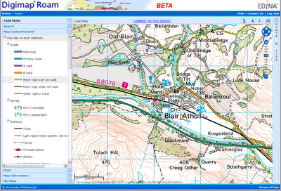
The new Roam facility (released in October 2009) replaces Classic as the standard mapping facility in Digimap OS Collection. Key features of Roam include: 12 fixed scale map views, click-and-drag navigation or “slippy maps” and enhanced printing options enabling you to generate printable PDF maps in landscape or portrait and A4 or A3 size. Roam is a significant improvement on Classic, providing many enhanced futures and an easier to use, more intuitive user interface.
Today, Monday 5 October, a new mapping tool is available to all registered users, through Digimap’s Ordnance Survey Collection.
Roam, the new mapping facility, is available as a BETA service and will therefore be subject to various improvements over the next few months. Planned changes include:
– additional print formats as alternatives to PDF
– inclusion of scalebar on printed maps
– provision of scale and extent indication on screen maps
– adding a “My Maps” function for bookmarking maps
Roam offers “click and drag” functions to locate your map, 12 map views at different scales, printing in PDF at both A3 and A4 sizes, search by place name, postcode or grid reference, seamless scrolling through the fixed scale maps and 5 customisable map views. You can access Roam from the icon above Classic in Digimap’s Ordnance Survey Collection home page.
We hope you will use the new facility and let us know what you think of it. There is a link within Roam for you to report any feedback you have (positive and negative). You can also email us on edina@ed.ac.uk or telephone us on 0131 650 3302.
Roam will replace the current Classic facility in January 2010.
New data
On Thursday 17th September EDINA released all available updates for data provided through Digimap’s Ordnance Survey Collection. Details of the versions of all the data offered can be found on the EDINA website here. The Digimap licence also now offers MiniScale and the OS 1:250,000 scale colour raster data. These are currently available through ShareGeo and will be added to the Data Download as soon as possible.
Architectural Changes
As well as updating the data, other significant changes have been made to the underlying technologies supporting Digimap. In short, we have replaced the entire GIS architecture which produces the maps you see online.
The new software, from Cadcorp, offers a number of benefits to both EDINA and end users of Digimap. As well as enhanced quality maps and faster map generation online, the printed output gives crisp, clear maps as PDF files. EPS files are no longer available from any facility within Digimap’s OS Collection, including Carto, but EDINA is working on the provision of additional formats to PDF.
New mapping facility: Roam
With the arrival of the new GIS software, EDINA has also developed a new mapping facility, called Roam. Still in a development phase, Roam offers the usual search functions as well as “slippy maps”, the click-and-drag function used to position a map, familiar to users of other popular online mapping facilities. It is easier to locate your map, easier to zoom in and out, and now offers maps at 12 different fixed scales. An additional small scale Ordnance Survey mapping product, MiniScale, has been included, and other datasets (e.g. Strategi and OS MasterMap) are available at more than one fixed scale.
Currently Roam is available as a Beta facility to site representatives only until Monday 5th October, when it will become available to all registered users of Digimap’s Ordnance Survey Collection. Roam is available from the OS Collection Home page; you will find the new icon next to those for Classic and Carto. It will be greyed out if you don’t yet have access to it.
Roam will run in Beta alongside the current Classic facility until January 2010 when Classic will be withdrawn entirely. Regular updates will be made to Roam to add new functionality, such as MyMaps, prior to its release as a full service in January 2010.
If you have any questions about this email or about Digimap in general, please do not hesitate to contact the EDINA Helpdesk on edina@ed.ac.uk
The current version of Digimap’s Classic facility (available through the Ordnance Survey Collection) is currently undergoing both a facelift and some reconstruction work!
Later this year we will be introducing “slippy” maps (drag the map with your mouse to move it around) and some new ways of saving your maps and producing printed copies. The new facility will offer the same maps and the same functions as those currently available but will be easier and more intuitive to use. Everyday use of online mapping technology has grown dramatically since the current version of Classic was released. Users’ familiarity with online mapping has increased and there are now common expectations of how map services online should work. The current re-engineering aims to accommodate these changes and build a service which meets those expectations.
Although this is still work in progress, below is a sneak preview of how the new version might look.
EDINA will operate both new and existing versions of this facility in parallel to ensure that a smooth transition is made between them. If you have teaching materials or help pages which are currently based on the existing version, there will be plenty of time to update them before the existing version of Classic is withdrawn.
A new geospatial data sharing facility has been released today which enables Digmap users to find and share geospatial datasets.
ShareGeo forms part of the EDINA Digimap suite of services and is accessible from the Digimap Collections main page in the ‘Find and Share’ section. It is free for all Digimap users to use.
Use ShareGeo to contribute your own (derived or user-generated) geospatial datasets, or to download datasets which are already there for your research, teaching or personal use.
Have you created a geospatial dataset for your dissertation? Do you use them in your teaching? Do you think they would be interesting/useful to others? If so, contribute them to ShareGeo and they will be accessible for download by other Digimap users*.
Geospatial datasets in a number of formats (raster, vector and tabular) can be contributed for anywhere in the world. A minimal amount of metadata is required for each dataset. Access ShareGeo by logging in to Digimap (http://edina.ac.uk/digimap) and then either follow the link on the Collections page to ShareGeo or click on the following link: http://digimap.edina.ac.uk/sharegeo/
*Licensing restrictions may apply to some datasets. If, for example, a dataset is derived from Ordnance Survey data, only Digimap users registered for Digimap’s Ordnance Survey Collection will be able to access it. Specific licence restrictions may apply to individual datasets and these must be adhered to.
EDINA have implemented a new geospatial data sharing facility called ShareGeo. It forms part of the Digimap Collections suite of services.
It is intended that ShareGeo will be accessible to all Digimap users at the beginning of February, however we are providing early access to it for readers of the Digimap blog (details of how to access it are below).
Please feel free to browse and download any datasets that are already there. If you have any geospatial datasets, we would ask you to contribute these to ShareGeo. ShareGeo is free to use for all registered Digimap users.
ShareGeo can be accessed after logging in to Digimap, using the following liks.
The visible link is not active, so you will need to go to ShareGeo by entering the following link in your browser: http://digimap.edina.ac.uk/sharegeo/ (Note: Once the facility is accessible to all, there will be a link on the Digimap Collections page to take you directly to ShareGeo)
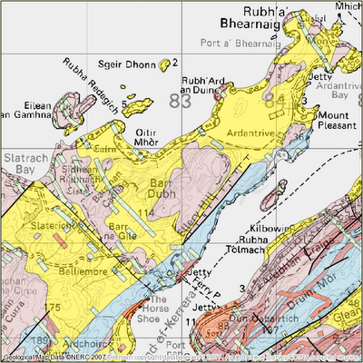
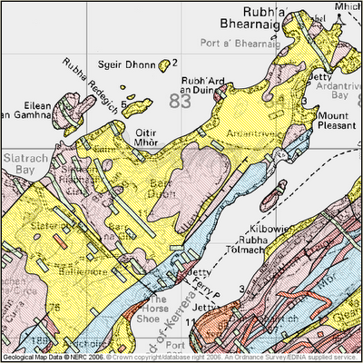
The Geology Maps facility in Geology Digimap has been greatly enhanced by upgrading the technology. The maps now use a transparency technique to represent rock types in colour, rather than hatching. The result has been much clearer maps, more closely matching their paper counterparts printed by the British Geological Survey. It also makes it easier to see the underlying context mapping, as well as identifying which rock types overlay which. Below are some examples of the new colour scheme.
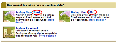
Old and new versions, clearly labelled
The previous version of Geology Maps is still available for those who have become accustomed to it or have created training courses based upon it. This version is clearly labelled “old“. It will be withdrawn at the start of the next academic year (2008/9) when we hope everyone will be enjoying the benefits of the new maps.
New style cartography, using transparency
Old style cartography, using traditional hatching methods