Any views expressed within media held on this service are those of the contributors, should not be taken as approved or endorsed by the University, and do not necessarily reflect the views of the University in respect of any particular issue.
Digimap is an online map and data delivery service, available by subscription to UK Higher and Further Education establishments. Operated by EDINA at the University of Edinburgh, Digimap offers a number of data collections, including Ordnance Survey, historical, geological, aerial photography, LiDAR, marine maps, land cover mapping, global mapping and census data. For more information about Digimap go to our website: https://digimap.edina.ac.uk Background image Contains OS data (c) Crown Copyright and database right 2022
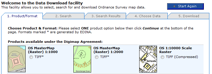
OS MasterMap data is now available to download in a rasterised (image) format from Digimap’s Data Download facility. If you need an image of OS MasterMap data (for example, as a backdrop map) but don’t need the complexity of the original vector data, this new stuff is for you.
OS MasterMap – detailed but complex
OS MasterMap is the most detailed product offered by Ordnance Survey. Maps made with with OS MasterMap have been available through Digimap’s mapping facilities since 2007, but if you wanted to use OS MasterMap as background for a customised map by overlaying your own data in a GIS you needed to download and convert the raw GML data. If all you want is a detailed colour background image, this seems like a significant investment of time.
Rasterised OS MasterMap – images not data
Digimap now offers OS MasterMap as .tif images at two scales: 1:1000 and 1:2000 through the usual Data Download facility. This saves you having to download, convert and import the data using specialist GIS software.
Where do I get the OS MasterMap raster background maps?
Log in to Digimap’s OS Collection, go to Data Download and select which scale of OS MasterMap image you want from the list of products. The images are tiled in 1km square tiles, so you can select your area of interest, and the tiles covering it, in the same way as other tiled datasets.
The scales are determined according to the distance on the ground represented by each pixel. The larger scale images are based on a measurement of 0.3125m per pixel. The smaller scale images are based on a measurement of 0.625m per pixel. These equate to approximate scales of 1:1000 and 1:2000 respectively, although these are dependent on the screen resolution of your monitor. You can easily display the maps at other scales, but some loss of image quality may occur if you do.
EDINA has been asked to post the following request for assistance from Ordnance Survey regarding the usability of particular datasets. Please follow the links below if you can help.
You may remember a similar survey being conducted in June 2010. This latest survey refers to different datasets.
Hello,
My name is Michael Brown and I work for the Ordnance Survey research department. My work includes the development and application of methods to improve the usability of OS products. I am currently exploring the use of questionnaires to evaluate the usability of our products and guide their further development. If you have any experience of the following Ordnance Survey products please follow the links provided and complete the questionnaire. Each should only take a few minutes to complete, and I would appreciate it if you could complete as many as you can.
If you have any questions feel free to contact me. Thank you for your time.
Dr. Michael Brown
Usability Specialist
Research, L1F2, Ordnance Survey
Adanac Drive, SOUTHAMPTON, United Kingdom, SO16 0AS
michael.brown@ordnancesurvey.co.uk
On Tuesday 1st March, EDINA will be updating the metadata for the historical maps in Historic Digimap. The metadata changes will affect only the Scottish County Series maps and will mean that some maps will appear to “move decade”. More details of the implications of these changes are given below.
Accuracy of publication dates
When the maps were originally scanned, the detailed marginalia on the original paper map sheets was not captured at the same time. The marginalia contained information such as the survey year, publication year, re-publication year (if applicable) and surveyor name. During the digitisation process only one year from the marginalia was recorded; it is assumed this was the publication year but there was always some uncertainty around this.
A joint project between EDINA and the National Library of Scotland (NLS) was undertaken to digitise the marginalia of the original paper copies of the historical maps held by NLS. The metadata captured included the Survey Year and Publication Year. Until now, the survey year of all maps in Historic Digimap was unknown. We now have the survey year for a significant number (but not all) of the County Series maps for Scotland at both 1:2500 and 1:10 560 scales.
The significance of this project to Historic Digimap is that we can now use the more accurate and reliable publication dates for many of the County Series maps to improve the mapping and download facilities offered. In order to make use of the new NLS publication dates, these were matched with the original metadata using a series of rigorous database queries and manual processing.
How many maps have changed?
Consequently, around 35,000 County Series map tiles* (18%) now have survey years. Of these, around 28,000 tiles also have a more accurate publication date. In the majority of cases (over 70%) the publication date has only changed by a year or two. For nearly 2,000 tiles the change in publication date is more than 10 years, with the largest single change being 39 years. For those tiles which have not had updates to the survey year, the Landmark publication year used remains unchanged.
So what does this mean for Ancient Roam and Historic Download?
Nothing has changed in Historic Download in terms of how historical maps can be found and downloaded, but the updated publication dates will be reflected in dates provided on the order summary page in the downloader. These will be more accurate and reliable than previously.
For Ancient Roam, there are some more significant effects. The publication date is used to determine which maps are visible in each decade given in the timeline along the top of the map screen.
Many of the maps for which the publication date has changed by one or two years will remain within the same decade and therefore will not be affected. However, for some maps a change of a year or two in the publication date may be enough to shift the map from one decade to another. For example, a map previously thought to have been published in 1889 but now known to have been published in 1901, originally appeared in the 1890s decade but now appears in the 1900s decade.
Where there have been more significant changes in the publication date some have resulted in entirely new decades being available in the timeline for particular areas. For example, in Forfarshire there were two County Series editions in the 1890s. This was because maps originally published in the 1860s and 1870s were re-published in the 1890s. So where no maps appeared for Forfarshire in 1860/70s, they do now!
Other maps with significant publication date changes tend to be odd outlying tiles that for some reason had a significantly different date from neighbouring tiles. This means that some odd ‘holes’ have been filled.
How do I find out the map date source?
In addition to the new survey and publication data information, the Map Details information box will also be updated. A new icon has been added to the tool bar to access the map information and the information box styling has been updated in keeping with the other Digimap Roam clients. Three new attributes have been added to the Map Details information: Year Surveyed (where applicable), Sheet Title (where applicable) and Date Source. The Date Source information will tell you whether the publication year came from the original Landmark data or the NLS metadata.
While these changes to Scottish County Series maps means that the per decade classification is now different, the changes mean that the dates are now more accurate. Our thanks go to the National Library of Scotland for their hard work on this project.
The updates to Historic Digimap will take effect on the evening of 1 March 2011.
*Map tiles refers to the ‘cookie-cut’ National Grid versions of the maps, not the original County Sheets
Digimap OpenStream, EDINA’s new open WMS service, was been updated with the latest version of MiniScale from the OS OpenData collection on 25 January 2011. The most significant changes to this dataset include improved ferry route labeling and a different representation of urban areas.
EDINA aims to provide the latest version of OS OpenData via the OpenStream service. This means that datasets may be updated part way through an academic year.
Work being undertaken by the University of Edinburgh will affect the availability of Digimap’s MasterMap Download facility from Friday 4th to Monday 7th February 2011.
MasterMap Download will be unavailable from 4pm on Friday 4 February until 12 noon on Monday 7 February and will continue to be at risk for the remainder of Monday 7th. We would encourage anyone wishing to take data for use the following week to take it prior to Friday 4th February.
While the maintenance work may be completed over the weekend, there is further software maintenance to be undertaken by EDINA following the University’s works. Currently it is difficult to estimate the length of time this will take, which is why MasterMap Download should be regarded as “at risk” for the remainder of Monday 7th February.
EDINA has been asked to post the following request for assistance regarding the usability of geographic information. Please follow the links below if you can help.
Hey Everyone,
My name is Michael Brown; I’m working with the University of Nottingham in conjunction with Ordnance Survey to develop a set of User Centred Design Tools for use with Geographic Information.
As part of this I am currently working on a questionnaire for the measurement of the Usability of Geographic Information. The next stage of this process is to validate the questionnaire by getting people to complete it, focusing on a few specific products. This will allow me to calculate how well it differentiates between different GI data sets as well as providing useful information about the products that will be fed back to Ordnance Survey.
If you have any experience with any of these products, I’d appreciate your help. Please follow the relevant link(s) and complete the questionnaire(s). This version is fairly short and should take less than 5 minutes to complete.
Feel free to complete more than one of them and please forward this on to anyone you think might be able to help me collect responses. If you have any questions, please feel free to contact me at: michael.brown@ordnancesurvey.co.uk
Over the years some problems have been reported with a few Land-Form PROFILE data tiles. Ordnance Survey have now provided us with updated versions of these tiles for which the problems have been fixed. The following tiles have been updated for both DTM and contour data:
hp50sw
nm80nw
nm80sw
nm87ne
nm87nw
nt87sw
ny47se
ny57sw
ny87sw
sd61ne
ss30ne
ss30nw
ss30se
ss30sw
ss31se
ss31sw
ss40sw
st20nw
st30se
st40ne
st40se
st50ne
st50nw
st50se
st57se
st76se
st85nw
st86nw
st86sw
sx39nw
sx49nw
sx57ne
sx57se
sy49ne
sy59nw
Thanks to those who have reported the errors in the data.
EDINA welcomes the release of Ordnance Survey datasets for free use and re-use. We are actively working to realise to the full the opportunities offered by this new policy for the enhancement and development of new and existing services for research and education.
As many will already know the Government published details on 31 March 2010 of the package of datasets and products from Ordnance Survey that are now available under OS OpenData – see http://www.ordnancesurvey.co.uk/oswebsite/opendata/. The list coincides partially with the datasets currently available through EDINA Digimap – see below. Note especially that OS MasterMap, the large-scale vector data, is only available through registration with EDINA Digimap.
The key task for EDINA Digimap is to provide ease and continuity of access to a whole range of geo-spatial datasets, including re-use in materials that are shared in research and teaching. We are therefore seeking clarification from Ordnance Survey regarding the licence terms that can now apply to the data available through Digimap which are now covered under OS OpenData.
The release of many Ordnance Survey datasets as open data is also good news for Unlock, the EDINA service which is there to help you geo-enable research data and other Internet-accessible documents and images. Unlock, and its predecessor GeoCrossWalk, were previously limited by license to academic use only. Relevant datasets now regarded as open data, including Boundary-Line, Code-Point® Open and the 1:50 000 gazetteer of place names, can now be used by Unlock Places, Unlock Text and Unlock Geocodes.
We are keen to learn from users of Digimap how you wish us to take best advantage of these changes in availability and licensing. Contact us by email on edina@ed.ac.uk or leave a comment on this blog.
Product Name
EDINA Digimap
OS OpenData
OS MasterMap Topography
Yes
No
OS MasterMap ITN
Yes
No
1:10 000 Scale Raster
Yes
No
nearest equivalent is OS StreetView
1:25 000 Scale Colour Raster
Yes
No
1:50 000 Scale Colour Raster
Yes
No
1:250 000 Scale Colour Raster
Yes
Yes
MiniScale®
Yes
Yes
Meridian™2
Yes
Yes
Strategi®
Yes
Yes
Land-Form PANORAMA® Contours
Yes
Yes
Land-Form PANORAMA® DTM
Yes
No
Land-Form PROFILE®
Yes
No
Boundary-Line®
Yes
Yes
Code-Point®
Yes
No
CodePoint® with Polygons
Yes
No
Code-Point® Open
(point data only; subset of Code-Point®)
MiniScale and 1:250 000 Raster data are now available in Digimap’s Ordnance Survey Collection Data Download facility.
The datasets have been available from the ShareGeo service for some time, but are now also available from within Digimap. In addition to the new products you can now also:
download the OS Land-Form PROFILE, 1:10 000 Contour data in DXF format
download Shapefile and MID/MIF versions of Meridian2 data
The new Meridian2 formats have their own entry on the Product & Format page of Data Download. These formats are available as national coverage, with a single download covering the whole of Great Britain. The NTF and DXF formats are still available as individual tiles.
Land-Line style maps available in Carto
Maps of OS MasterMap data in Carto can now be styled to look like previous Land-Line.Plus maps. This is particularly useful for black and white printing or to recreate Land-Line.Plus data for comparison with older printed maps.
Yesterday, Tuesday 26 January 2010, some changes were made to Digimap. These are detailed as follows:
1. Classic removed from Ordnance Survey Collection.
As advertised on 5 October 2009 and 6 January 2010 this old facility has been removed and replaced by the new Roam facility. You can find a demonstration of Roam on the EDINA website: Roam demonstration
2. Historic Digimap “preview map sheet” button has been removed.
This function used out-of-date technology to render the original historical map sheets in the browser window. It was extremely slow and was dependent upon software installed on a machine which is being decommissioned. It is much quicker and more user-friendly to download the map sheet required and view it locally.
3. Marine Digimap Hydrospatial data updated.
The 2009 version of SeaZone’s Hydrospatial data is now available through Hydrospatial Download. Late delivery of the data has meant a delay of the release from September 2009 to January 2010.