Any views expressed within media held on this service are those of the contributors, should not be taken as approved or endorsed by the University, and do not necessarily reflect the views of the University in respect of any particular issue.
Digimap is an online map and data delivery service, available by subscription to UK Higher and Further Education establishments. Operated by EDINA at the University of Edinburgh, Digimap offers a number of data collections, including Ordnance Survey, historical, geological, aerial photography, LiDAR, marine maps, land cover mapping, global mapping and census data. For more information about Digimap go to our website: https://digimap.edina.ac.uk Background image Contains OS data (c) Crown Copyright and database right 2022
Following an unscheduled outage over the past 24 hours, MasterMap Download is now available again.
However, Topographic Layer orders are limited to 25sq.km and all orders may take longer than the advertised 2 days to process. Please be patient and do not resubmit your order.
We aim to restore full service early next week. Further information will be posted here when available. Apologies for the inconvenience.
Following this afternoon’s diagnostics test, MasterMap Download is now available but running under reduced capacity. Orders for Topography Layer are limited to 5 x 5 km (25 sq. km) as a temporary measure.
Between 07.30 and 09.30 hrs on Thursday 24 September, MasterMap Download will be unavailable to allow a fix to be applied. Further information on its success will be available thereafter.
The MasterMap Download facility will be temporarily withdrawn at 14.00 hours today, Wednesday 23 September 2009.
Currently, significant software faults are causing most data orders to fail and the system is unstable. Withdrawing access will allow EDINA to undertake diagnostic work to identify a solution to the problem. External software suppliers are also involved.
As yet, we do not know how long the service will need to be unavailable, but futher information will be posted here and on the Digimap login page, as and when it is available.
Should you have an urgent data order, please contact the EDINA Helpdesk with details of the data you require. We cannot process orders immediately, but we may still have an opportunity to meet the advertised 2-day delivery schedule. This very much depends on the problem identified.
New data
On Thursday 17th September EDINA released all available updates for data provided through Digimap’s Ordnance Survey Collection. Details of the versions of all the data offered can be found on the EDINA website here. The Digimap licence also now offers MiniScale and the OS 1:250,000 scale colour raster data. These are currently available through ShareGeo and will be added to the Data Download as soon as possible.
Architectural Changes
As well as updating the data, other significant changes have been made to the underlying technologies supporting Digimap. In short, we have replaced the entire GIS architecture which produces the maps you see online.
The new software, from Cadcorp, offers a number of benefits to both EDINA and end users of Digimap. As well as enhanced quality maps and faster map generation online, the printed output gives crisp, clear maps as PDF files. EPS files are no longer available from any facility within Digimap’s OS Collection, including Carto, but EDINA is working on the provision of additional formats to PDF.
New mapping facility: Roam
With the arrival of the new GIS software, EDINA has also developed a new mapping facility, called Roam. Still in a development phase, Roam offers the usual search functions as well as “slippy maps”, the click-and-drag function used to position a map, familiar to users of other popular online mapping facilities. It is easier to locate your map, easier to zoom in and out, and now offers maps at 12 different fixed scales. An additional small scale Ordnance Survey mapping product, MiniScale, has been included, and other datasets (e.g. Strategi and OS MasterMap) are available at more than one fixed scale.
Currently Roam is available as a Beta facility to site representatives only until Monday 5th October, when it will become available to all registered users of Digimap’s Ordnance Survey Collection. Roam is available from the OS Collection Home page; you will find the new icon next to those for Classic and Carto. It will be greyed out if you don’t yet have access to it.
Roam will run in Beta alongside the current Classic facility until January 2010 when Classic will be withdrawn entirely. Regular updates will be made to Roam to add new functionality, such as MyMaps, prior to its release as a full service in January 2010.
If you have any questions about this email or about Digimap in general, please do not hesitate to contact the EDINA Helpdesk on edina@ed.ac.uk
There is a lot to know about UK postcodes! Here are some interesting key facts:
There are around 2 million postcodes in the UK, covering something like 29 million addresses.
A postcode is made up of four constituent parts. Take the postcode EH9 1PR as an example:
The postcode Area is indicated by the initial one or two letters: EH
The post District is indicated by the one or two numbers following the Area: EH9
The postcode Sector is indicated by the number after the District: EH9 1
The postcode Unit is indicated by the full postcode: EH9 1PR
Some buildings can contain delivery addresses with different postcodes. High-rise residential buildings are a good example of these. As far as the Code-Point dataset is concerned these are called Vertical Streets, and their boundaries are recorded as regular squares. These are clearly visible when the postcode boundaries are mapped.
Usually postcodes cover around 15 delivery addresses, although this isn’t a hard and fast rule.
Some postcodes apply to only one address or building. Ordnance Survey’s postcode is SO16 4GU. Buckingham Palace also has it’s own postcode, SW1A 1AA, and 10 Downing Street’s postcode is SW1A 2AA. The House of Commons is SW1A 0AA
Postcode unit boundaries (which form the OS Code-Point Polygons dataset) are mathematically calculated around a centroid and are not based on physical boundaries visible on the ground. This centroid is calculated using the coordinates for the delivery points in each postcode. These are not necessarily the precise geographic coordinats of the letterbox in your front door!
The Code-Point dataset offered through Digimap provides much more information than just the postcode and the coordinates of it’s centroid. Additional information includes the NHS Region code, Ward name, how many delivery addresses are in that postcode, how many of those are domestic or business delivery points. The range of information given is different for Scotland from England and Wales.
These enable you to link additional information to the postcode if it is already associated with a code common to the postcode dataset e.g. you can identify which postcodes are associated with data you have collected using Ward codes.
You can use Digimap’s Postcode Query facility (in the Ordnance Survey Collection) to look up the additional information about a particular postcode.
You can use Digimap’s Boundary Download facility to download the Code-Point data and the associated polygons.
Are you using Ordnance Survey data in an innovative way? If so, enter the competition and you could win a prize!
EDINA and Ordnance Survey are pleased to announce a competition to find the most innovative use of Ordnance Survey data. To enter the competition you need to submit a summary of your work which describes what you were trying to achieve, what Ordnance Survey data you used (and how), what makes the work and the use of the data innovative, and how the data could be improved to make the work easier, or to have made more possible.
Full competition details
Full details of the competition can be found here. Please ensure you read this document carefully before submitting your application.
Grand Prize The winner will receive £250 of Amazon vouchers to distribute amongst project colleagues plus travel, accommodation and conference fees for one or more researchers, up to a total value of £1,500, to a conference of your choice. There are second and third prizes of £250 and £100 in Amazon vouchers.
Closing date
The closing date for entries is midnight on Saturday 31st January 2009. Entries may be submitted by email or on paper.
Digimap will cease to deliver Land-Line.Plus data at the end of August 2008.
As a registered Digimap user you may continue to hold and use any Land-Line.Plus data you already have until 31 July 2009. Beyond this date, you will be required to delete any Land-Line.Plus data you hold, and will not be licensed to use it thereafter.
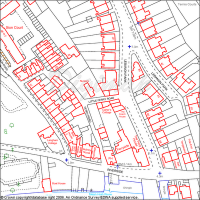
Land-Line map of urban area
Land-Line.Plus has been replaced by OS MasterMap Topography Layer. These data are available from Digimap’s MasterMap Download facility, within the Ordnance Survey Collection. The OS MasterMap Topography Layer is as detailed as Land-Line.Plus but contains a much richer attribute set. It is also available in GML format, rather than NTF.
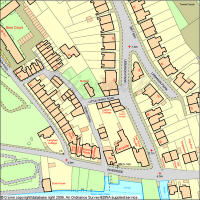
Corresponding OS MasterMap Topography Layer map of urban area
More information about OS MasterMap can be found within the Digimap Help pages.
After 1 August 2008 you will need to use OS MasterMap Topography layer instead of Land-Line data. Land-Line is the most detailed data available through the Data Download facility within Digimap’s OS Collection. It has been replaced by OS MasterMap Topography layer, which is equally detailed and available through the MasterMap Download facility.
Two OS MasterMap Layers, Topography and Integrated Transport Network, have been available from Digimap’s OS Collection since September 2007. These layers are available through the MasterMap Download facility. You can read more about OS MasterMap data on our OS MasterMap website and within the Digimap Help pages. Look in the sections under MasterMap Download and Data Information.
There are several software packages available which make the process of loading and viewing the OS MasterMap in GIS applications quite simple, more simple than using Land-Line data, in fact. These are in addition to ‘built-in’ converters supplied with the most recent versions of ArcGIS (Productivity Suite), MapInfo and AutoCAD software.
Viewing data
If you wish to simply view the OS MasterMap data (rather than undertake any spatial analysis, querying or manipulation), there is a simple viewer produced by Snowflake Software. It is called the OS MasterMap Viewer and can be downloaded for free (upon registration) from the Snowflake website.
MapInfo
The following applications are free and will load OS MasterMap, fully represented, into MapInfo:
InterpOSe (Digimap Edition) from Dotted Eyes. This is available free of charge on registration with Dotted Eyes. It includes full OS MasterMap styling, and will convert data to various file formats, including Shape, TAB, mid/mif and DWG/DXF.
ArcGIS
The following applications are freely available:
Productivity Suite 1.1. This is freely available to those licensed to use ArcGIS through Eduserv Chest. It contains MapManager and will convert OS MasterMap to Geodatabase format and comes complete with a number of layer files for representation (details can be found in the local installation folder of Productivity Suite). You will need a special Athens username and password to access the software download area. This should be available from your local Chest Representative or ESRI Technical Contact.
InterpOSe (Digimap Edition) from Dotted Eyes. This is available free of charge on registration with Dotted Eyes. It includes full OS MasterMap styling, and will convert data to various file formats, including Shape, TAB, mid/mif and DWG/DXF.
AutoCAD
InterpOSe (Digimap Edition) from Dotted Eyes. This will convert OS MasterMap to DXF and DWG and has a template file (.DWT) for representing the data using OS style. InterpOSe can be downloaded for free from Dotted Eyes website on registration there.
There are other packages and resources available which are detailed on our OS MasterMap website. Ordnance Survey also provide information about software which will read OS MasterMap data.
Instructions on using MapManager 9.1 and InterpOSe are included in the Digimap Help pages. Look in the section labelled “Using Data with GIS”. If you have any questions about the information provided here, please contact the EDINA Helpdesk on edina@ed.ac.uk or 0131 650 3302.
Are you coming to the end of your course? Are you changing jobs and moving to a different University or College? Are you retiring? If so, there are some issues relating to the use of Digimap which you should be aware of.
IF YOU ARE GRADUATING, OR YOUR COURSE IS COMING TO AN END… …you will cease to be a member of a subscribing institution and therefore will no longer be a Digimap Authorised User. This means you must delete any data you hold from Digimap. You may keep paper maps (including those which form parts of reports, coursework and dissertations), but not digital data.
IF YOU ARE CHANGING JOBS OR MOVING TO A DIFFERENT COLLEGE OR UNIVERSITY…
…you need to check whether your new institution subscribes to any of the Digimap Collections. If your new institution is NOT a subscriber to a particular Collection, you may not retain any digital data from that Collection in your new job. If you wish to use Digimap in your new job, and your new institution is also a subscribing institution, you will need to register with Digimap using login credentials from your new institution.
IF YOU ARE LEAVING AN EDUCATIONAL INSTITUTION AND GOING TO WORK FOR A COMMERCIAL OR CHARITABLE ORGANISATION…
…you will cease to be a Digimap Authorised User. This means you must delete any data you hold from Digimap. You may keep paper copies of maps (including those which form part of reports or dissertations), but not digital data.
WHAT IFS…
There are some circumstances where you may continue to be an Authorised User, even if you are graduating, or leaving your current institution. If you are retiring, you may continue to have rights to access your institution’s electronic resources. If you are graduating from your first degree and staying at the same institution to undertake a PhD, you will continue to be a member of your institution and therefore eligible for access to Digimap. If you believe you should continue to have access to your institution’s resources, you should check with your Digimap site representative whether this applies to Digimap too.
The rules of eligibility apply to all Digimap Collections. These rules revolve around the definition of “Authorised User” as specified in the licence agreement for each Collection. You can find these on the EDINA website at: http://edina.ac.uk/digimap/terms.shtml
A NOTE FOR SITE REPRESENTATIVES… Access to any electronic resource relies on subscribing institutions maintaining authentication and authorisation systems effectively and efficiently. An example of good practice in this regard would be deactivating local user accounts when students graduate or leave your institution. You may wish to check what your local practice is.