Any views expressed within media held on this service are those of the contributors, should not be taken as approved or endorsed by the University, and do not necessarily reflect the views of the University in respect of any particular issue.
Digimap is an online map and data delivery service, available by subscription to UK Higher and Further Education establishments. Operated by EDINA at the University of Edinburgh, Digimap offers a number of data collections, including Ordnance Survey, historical, geological, aerial photography, LiDAR, marine maps, land cover mapping, global mapping and census data. For more information about Digimap go to our website: https://digimap.edina.ac.uk Background image Contains OS data (c) Crown Copyright and database right 2022
Digimap has become a teenager today, 10th January 2013. There have been some big changes to the service over the years, with interfaces coming and going and Ordnance Survey maps being joined by Historic (2005), Geology (2007), Marine (2009) and soon Environment (2013).
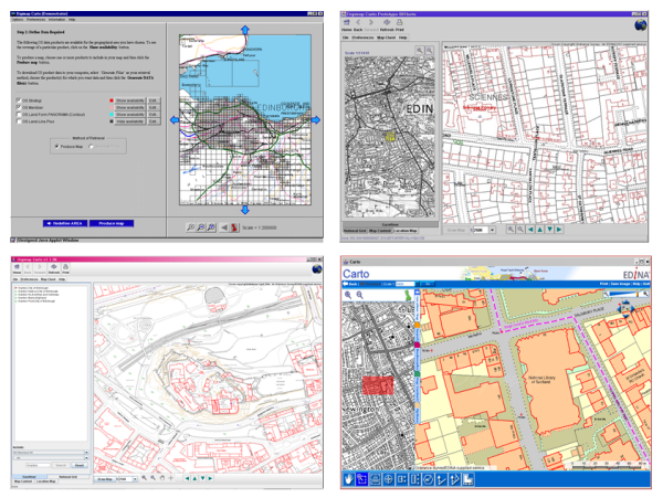
How Digimap Carto has changed since the service launched on the 10th of January 2000.
We’d really like to thank all our site reps and other institutional staff who have supported and promoted the service over the last 13 years.
Remember you can have your say about any of the Digimap Collections in the Impact Surveys available in the service and listed below. Please fill one in to let us know how we are doing and help us improve the service for the future:
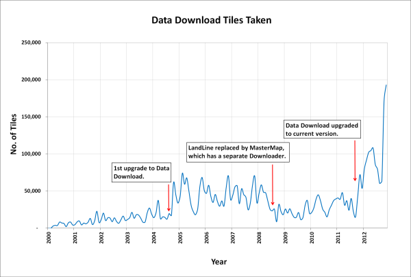
In January 2013 the OS MasterMap®, Boundary-Line™ and Code-Point® data products will be available from the Data Download service. We have tried to keep the changes necessary to accommodate these products to a minimum as the current interface has proved so successful (190,000 map tiles and files downloaded Nov 2012).
Here is a list of the changes and additions you will see in the interface; please note that they may still be subject to some change prior to launch.
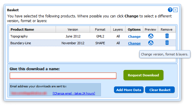
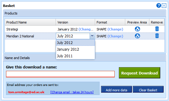
Both Boundary-Line and MasterMap have layers so we have had to make changes to the basket:
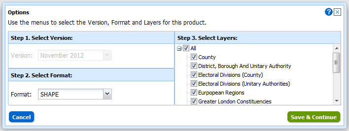
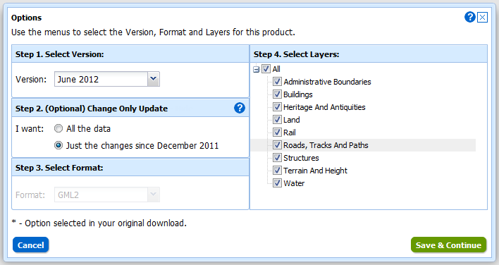
Instead of selecting Version and Format using drop-down menus there is a new pop-up for changing both these and the layers for each of the products in your basket. You can access this pop-up by clicking on the Change link in the Options column:
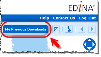
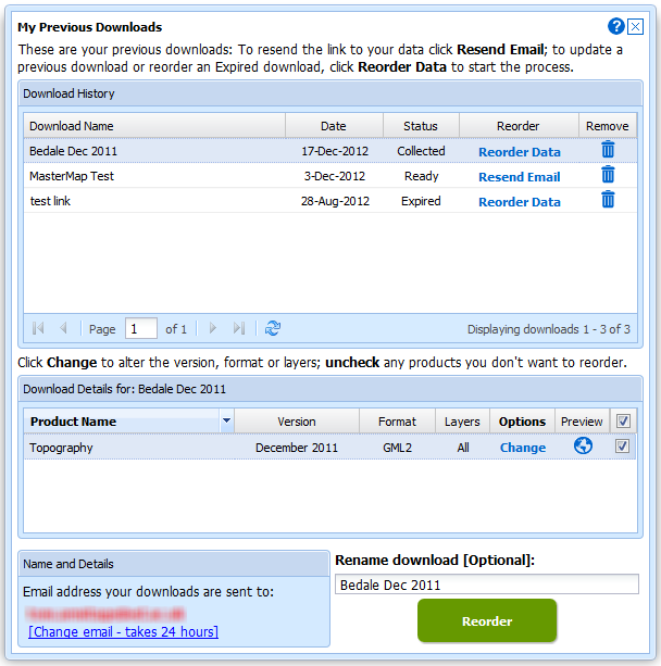
We have also improved the “My Account” section which is now called “My Previous Downloads”:
Once in the interface you can access any of your past downloads and reopen them at the basket stage:
It is now much easier to update your previous downloads to the latest version, get the same data in a different format or simply reorder data you have previously taken. In addition to these functions we have incorporated the ability to make Change-Only-Updates (COUs) to MasterMap Data:
Both Boundary Download and MasterMap Download will be kept in service for a transition period but as there are so many benefits to using Data Download we hope everyone will make the switch quickly. We expect to have switched off these services by the end of April.
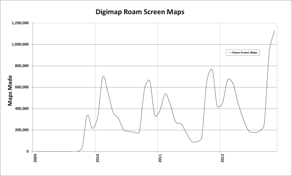
November was a record month for the Digimap Service with over 2 million screen maps made by the four collections. Digimap Roam made over 1 million screen maps alone and also broke its record for the number of print maps generated, over 28,000.
The number of files downloaded was also a record for Digimap with nearly 250,000 map tiles or files taken from the four collections. The Data Download facility for the Ordnance Survey Collection provided the bulk of these, over 190,000. Since the introduction of the new Data Download there has been a great deal more data supplied to staff and students but October and November have seen a huge spike. This has also been achieved from a lower total number of orders showing how the changes made in the upgrade have greatly improved the efficiency of the process. It is now much easier to get all the data you need in a smaller number of orders.
On top of the downloads from the Digimap Collections, ShareGeo Open also had a record month. ShareGeo Open is a repository for open spatial data that promotes the sharing and re-use of spatial data in teaching and learning.
There were over 3400 downloads of datasets from the service, nearly double last November’s total. There are almost 200 different datasets available from the service, with the recent addition of wind farm locations for the UK proving popular. The most downloaded dataset for the past 6 months is the Postcode Areas file, made from the Code-Point Open data.
We have a few events coming up that will help you get to grips with aspects of the Digimap service. The next course is a face to face training session at Leeds University on Thursday the 15th of November covering the basics of what is available from the Digimap collections.
Webinars are open to all Digimap users whereas the face-to-face training is aimed at staff researchers and postgraduates. Do note that we have a couple of sessions coming up in the South West of England where we haven’t been for a while.
For a full list and details of how to book, go to the Training page on the blog or go to the Training and Events list on the main EDINA website:
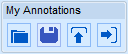
From left to right: “View saved annotations”, “Save annotations”, “Import” and “Export”.
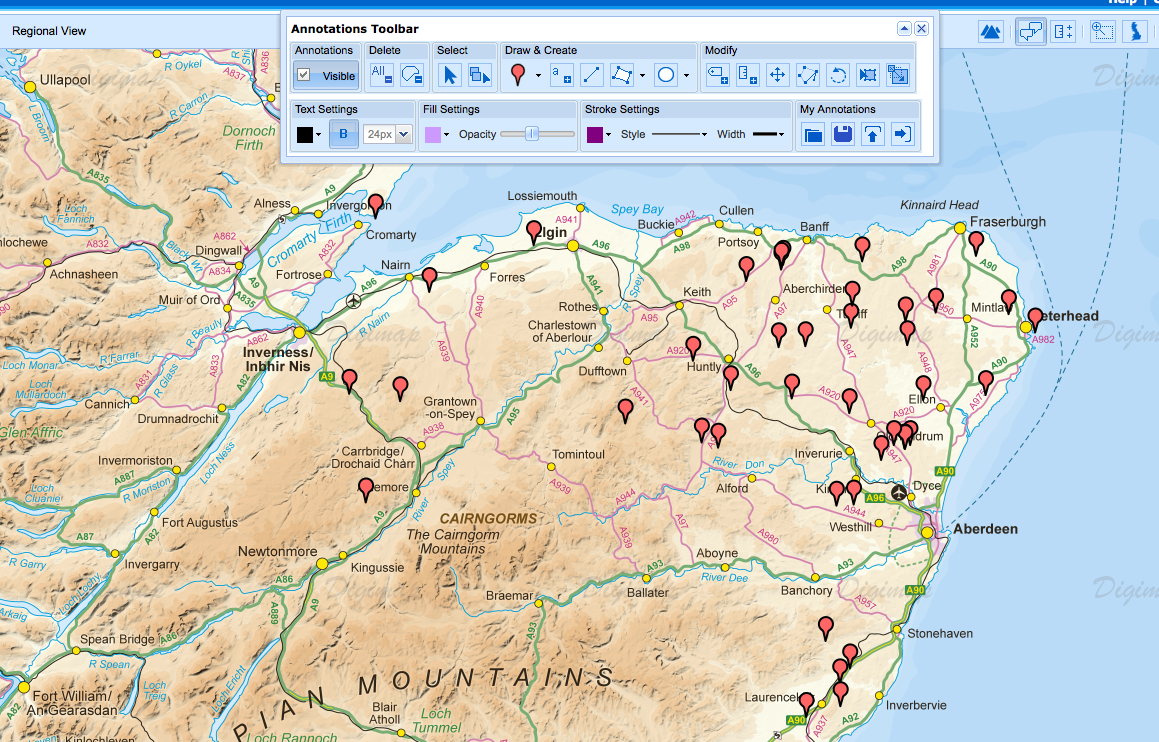
Recent enhancements to all Roam applications in Digimap (OS, Geology, Ancient and Marine) mean you can now save, import and export annotations. The new tools can be found under the ‘My Annotations’ set of tools on Annotations Toolbar.
The new Save function enables you to work on creating and editing annotations in more than one Digimap session. You can now save your work and come back to it another day. Hit the Save button to store your annotations and retrieve them any time by clicking the ‘View saved annotations’ button. Any annotations that you save in one application (e.g. OS Roam) can be opened in any other Roam client (e.g. Ancient Roam) you have access to. This is a great function that enables you to digitise a set of annotations based on one type of map, and then open them up in another Roam application to view on a different type of map. For example, you could use OS Roam to annotate a detailed map showing a proposed new building. You can then save those annotations and open them up in Geology Roam to view the geology underneath your proposed new building.
If you have a spatial dataset, you can now import it into any Roam application to view those features as annotations. This could be a dataset you have created in a GIS, downloaded from Digimap or another data provider, tracks or points surveyed using a GPS unit or a geocoded table of survey results. You can import Shapefiles, KML, GPX, CSV and GeoJSON datasets. Click the ‘Import’ button under ‘My Annotations’ on the toolbar and navigate to your dataset to import. This feature means you can quickly and easily visualise datasets that you have created or obtained from elsewhere on top of maps in any of the Roam clients.
Proposed Wind Farm locations dataset downloaded from ShareGeo Open (http://hdl.handle.net/10672/294) as a shapefile and imported into Roam as annotations.
In addition to importing, you can also export your annotations in Shapefile, KML and GeoJSON formats by clicking on the “Export” icon on the My Annotations tools. These formats cover the most popular GIS and Web Mapping software packages, such as ArcGIS, Quantum GIS, Google Earth and OpenLayers.
NOTE:If you create annotations by tracing features on a Roam map you will need to credit any maps you go on to make using the annotations with the appropriate copyright statement. Any geographic data you generate from a map is called “derived data” and is still copyright to the creators of the original map.
The copyright statement is added automatically if you print the map from Roam, however you will need to add in the statement manually if you export annotations and use them in other software. The statement to include can be found in the Terms of Use for the service you are using, just click the link a the bottom right of the Roam interface.
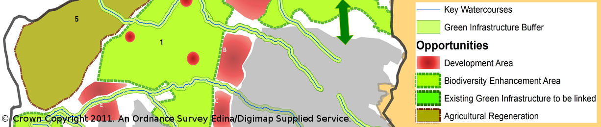
We have been busy over the last few months collating a new set of case studies showing how the different Digimap collections are being used. There are 13 new examples covering subjects as diverse as Archaeology, Religious History, Palaeontology and Geochemistry, as well as more traditional subjects like Landscape Architecture.
Green Infrastructure Study of Cheltenham and Gloucester: David Green
The new case studies can be found in the Digimap Support pages along with the previous examples we have collected over the years:
If you would like us to feature your work as a Case Study then please get in touch with us: edina@ed.ac.uk. We are especially keen to hear from those using Marine Digimap.
Every year EDINA conducts a survey of its users to make sure that its services are meeting expectations and to find out what we should be doing to develop them further.
These surveys are very useful and have helped us prioritise the development of Digimap and our other geoservices. This year we redeveloped the Data Download facility and have begun the replacement of Carto because you told us they were areas you’d like to see improved. Other upcoming work prioritised by the surveys includes better print interfaces across all services and printable legends for Geology Roam.
As you can see it is beneficial for you to take part, so we’d really like you to let us know how we are doing. Please fill in a survey for each of the services you use; they can be found here:
Digimap Carto has been making maps for nearly 13 years now, though it last received a major facelift in 2006. Although it is still well used the underlying technology is no longer a viable platform to develop on. It has simply become too difficult to maintain in today’s environment of almost monthly changes to web browsers and the Java Runtime Environment.
Thankfully these advances in browser technology, and our underlying GIS and web mapping software, mean that we can now provide a Carto like service without the Java applet. In 2013 we will be launching a replacement for Carto that will run directly in an up-to-date web browser and still include advanced functionality. Until the new interface is launched we will keep Carto running, please go here if you are having trouble getting it to work: Carto Notes
With work starting on the new advanced mapping application we would really like to know which functions you value most in Carto. We’d also like to hear your ideas for any new features you would like to see available. We can’t promise to include everything, but knowing what you want helps us to make informed decisions.
When Digimap was first launched in 2000 we consulted our users to find out how often they wanted the service updated. We found that at the time, the majority of our users wanted consistent maps and data throughout the academic year. Therefore it became Digimap policy to only update the information during the summer break so that new mapping became available for the next academic year.
As the new Data Download allows access to previous datasets during each academic year there will always be a dataset that remains constant throughout the year for those who require it. Therefore we have decided to update the maps as soon as possible after we receive the new data.
We still get most of our data updates in late spring/early summer so it is likely that you may not notice any difference to when the updates arrive, however the default setting will be to offer the most up-to-date data we have. If an update has come in since the start of the academic year you will need to change the version from the default to get the previous data.
We will use the blog notify you of any maps and data changes we make; you can see the dates of all the Ordnance Survey data we have available here:
Recently we have discovered a handful of users have found maps failing to load in Digimap’s mapping applications. All other tools are available, just the map is missing.
This appears to be caused by anti-virus software installed on the users computer blocking the maps streamed from Digimap. Adding Digimap to the list of trusted sites should resolve this problem, although the specific format of the URL to trust is important. If maps are failing to load for you too, please check that Digimap is listed as one of your trusted sites. If Digimap is listed and the maps still fail to load, please contact us for assistance. We will need to know the name and version of the anti-virus software you are using.
If your computer is centrally administered by your institution you may need to contact Computing Services for assistance to amend your list of trusted sites.