Digimap Update for the 2018-19 Academic Year

It is the start of a new academic year and we have introduced few new things for you to see in Digimap:

A New Home Page

Digimap has a new home page! It may look a little different, but it works in exactly the same way as the previous version. Responding to feedback from the community we have provided more detail about each collection in the left hand panel, including preview images of the data. Roam and Data Download are easy to find under each Collection’s tab.

Global Digimap

We are very proud to announce the launch of our new Global Digimap collection.  This is a new service, developed in response to requests for international data.  Initially Global Digimap will offer OpenStreetMap data but our objective is to develop the collection in partnership with the user community, so user feedback will shape both the content and functionality.  In return for this engagement, access to Global Digimap will be free of charge until July 2019.

We have asked all the Digimap Site Reps if they would like access to the service, if you can’t access Global Download then speak to your site rep about getting your institution switched on: List of Digimap Site Reps

There is a blog post with more detail about the Global Digimap Service.

Upgrade for Data Download

Following a lengthy beta phase, we have promoted the beta version of Data Download to a production service and this is now the default Data Download application for all Collections.  Ever mindful that work flows, and teaching and promotion materials may need updating as a result, we will continue to run the previous versions of both Roam and Data Download until the end of the year.  All saved maps and data download histories are available in both new and old versions.

New Licences

Digimap is now operating under new licences for 2018/19 so all registered users are required to accept the new terms.  This is a simple process which happens when you first log in. No re-registration is required and all saved maps and data download histories remain available as before.

Maps and Data Updates: Digimap Policy Change

When Digimap was first launched in 2000 we consulted our users to find out how often they wanted the service updated. We found that at the time, the majority of our users wanted consistent maps and data throughout the academic year. Therefore it became Digimap policy to only update the information during the summer break so that new mapping became available for the next academic year.

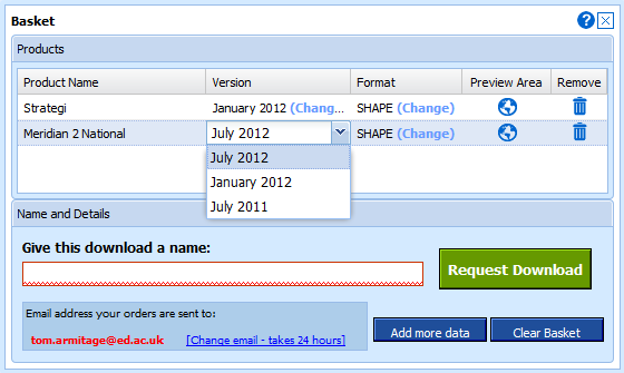
As the new Data Download allows access to previous datasets during each academic year there will always be a dataset that remains constant throughout the year for those who require it. Therefore we have decided to update the maps as soon as possible after we receive the new data.

We still get most of our data updates in late spring/early summer so it is likely that you may not notice any difference to when the updates arrive, however the default setting will be to offer the most up-to-date data we have. If an update has come in since the start of the academic year you will need to change the version from the default to get the previous data.

Select Version, Data Download

We will use the blog notify you of any maps and data changes we make; you can see the dates of all the Ordnance Survey data we have available here:

Digimap Data Update Dates

If you have any concerns about the maps in Roam or Carto changing midway through an academic year then please let us know: edina@ed.ac.uk

New 1:25,000 scale raster in Roam, Carto and Data Download

The 1:25,000 scale Raster mapping has been updated in Digimap Roam, Carto and Data Download. This new data is the latest release by Ordnance Survey from May 2012. There has been quite a few changes with just under a third of the country seeing updates with this release.
Some of the areas with the most changes have been in the Scottish Highlands and the main London 2012 Olympic site in East London.
It is great to see (what looks like) the mapping completed for the site, and to compare how it has taken shape over the last year. Download the maps from Data Download to view the changes for yourself.

Spot the difference between the Olympic site maps - 2011 (left) and 2012 (right)