OS Building Height Attribute now available in file geodatabase format

3D Building Heights in ArcGIS
© Crown Copyright and Database Right 2015. Ordnance Survey (Digimap Licence)

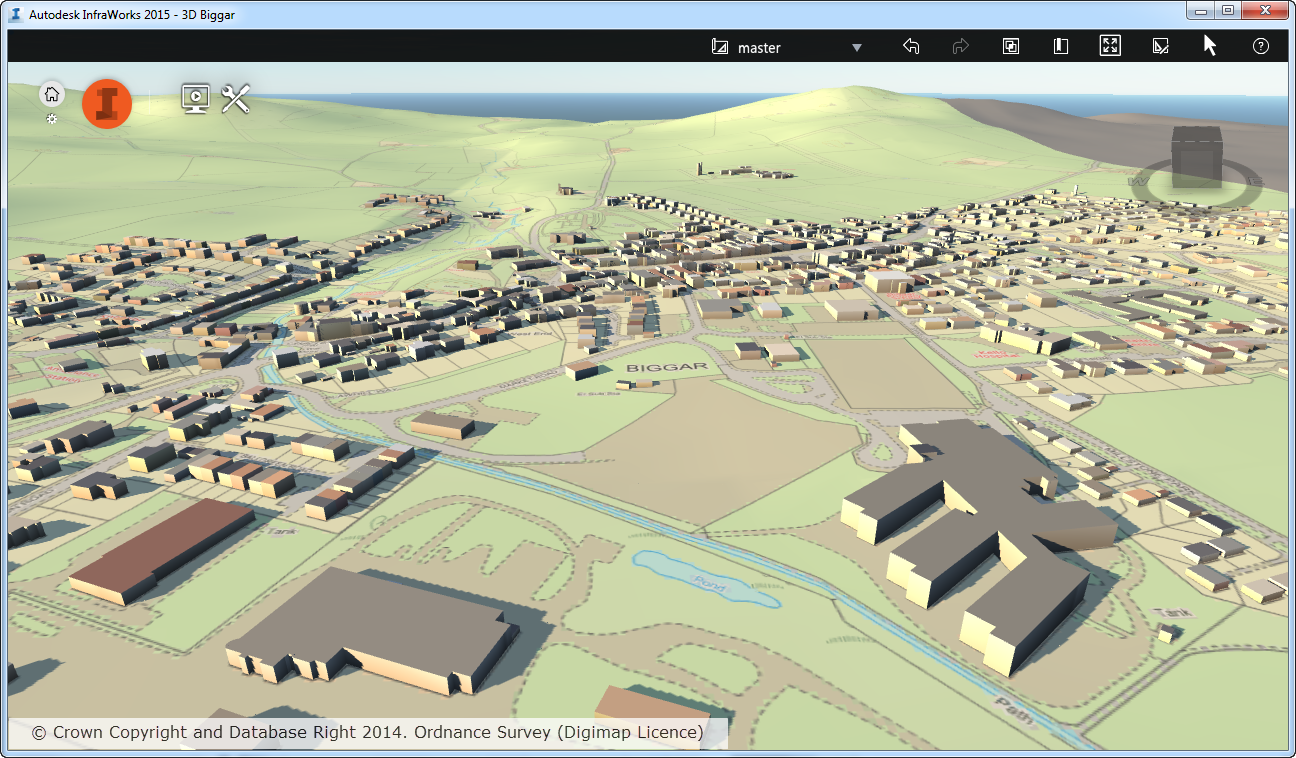
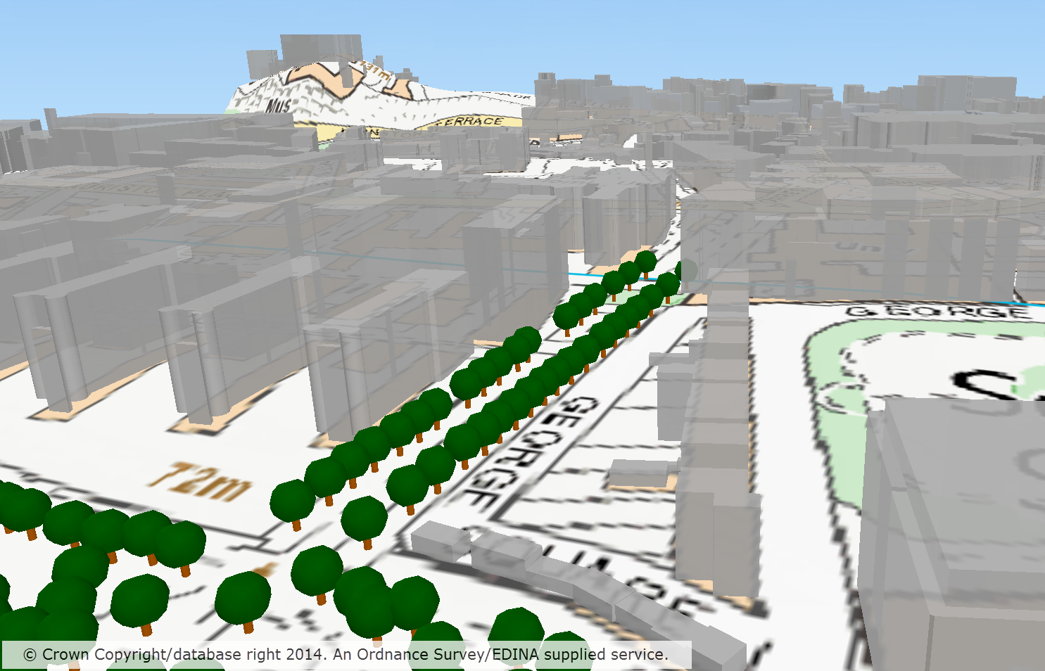
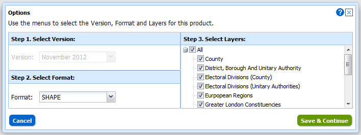
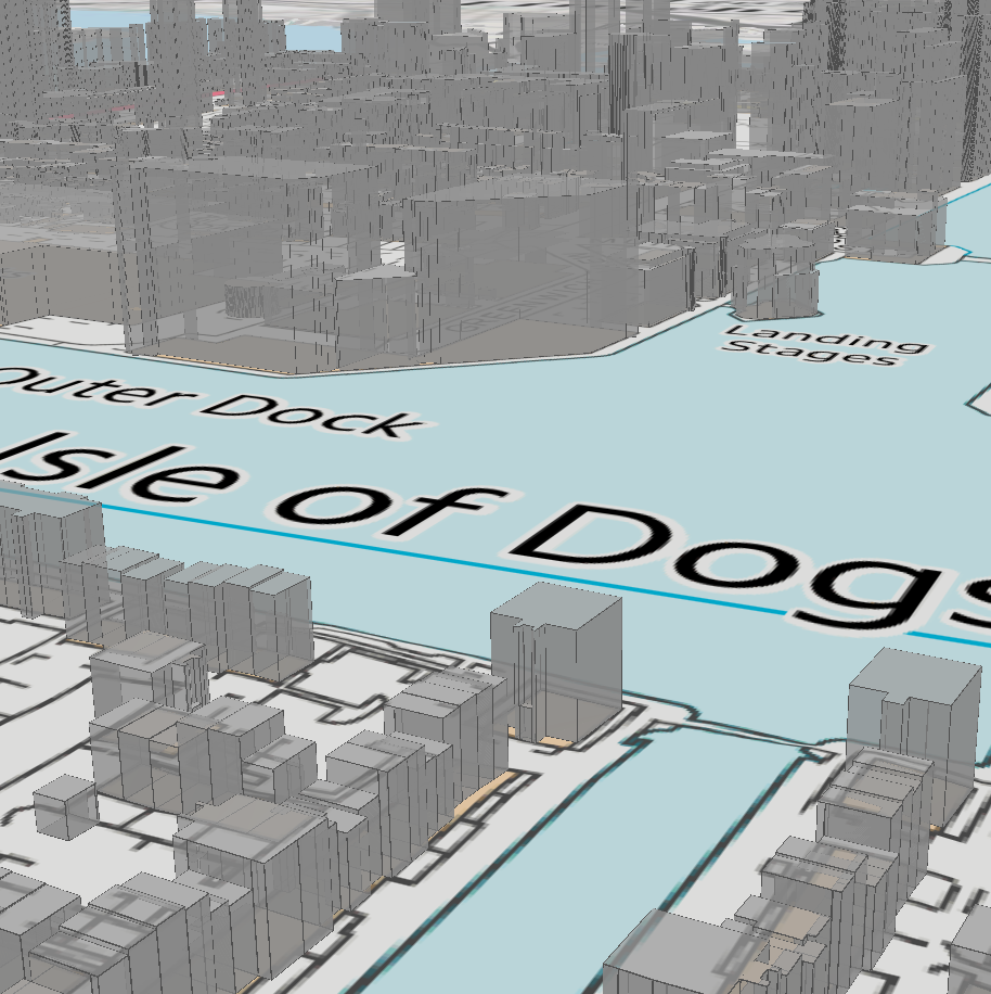
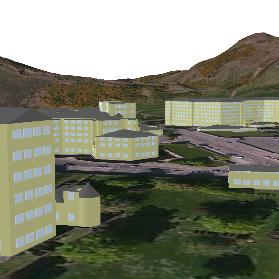
We are pleased to announce that users can now download OS MasterMap Building Height Attribute data in file geodatabase format. The data consists of building polygons together with the building height attributes supplied by OS in the latest alpha release of their Building Height Attribute dataset (December 2014 at the time of writing).

This makes the process of visualising the data in 3D much simpler for the majority of GIS users. The file geodatabase format can be read by both QGIS and ArcGIS, including the new ArcGIS Pro, without the need for any complex data processing. Making the data available in file geodatabase format removes the need for users to download building features from OS MasterMap Topography Layer and then use the JOIN function in GIS to connect the Building Height Attribute data to the buildings.

3D Buildings in ArcGIS
© Crown Copyright and Database Right 2015. Ordnance Survey (Digimap Licence)

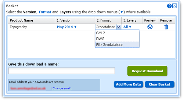
The data is supplied on a 5x5km grid, so you may receive multiple separate geodatabases if your area covers multiple 5km grid cells, however it is easy to merge the datasets together using common GIS functions.

We hope this makes it much easier to use the data but we welcome any feedback you may have.

  • Email: edina@ed.ac.uk
  • Phone: 0131 650 3302

Digimap Data: New datasets coming in the New Year

The new Ordnance Survey Licence includes some new and very interesting datasets for the Digimap service. We have already added OS Terrain 5, Ordnance Survey’s most detailed digital terrain model and contour data to the the Data Download facility. The other new datasets will require some additional effort to add into the service but we should have them available to download early in the new year. These new datasets are as follows:


OS MasterMap ITN Urban Paths

Routing information for walkers and cyclists in towns and cities.

More Info from Ordnance Survey…

OS MasterMap Sites LayerOS MasterMap Sites Layer

Identifies areas as being in categories such as schools, hospitals, transport facilities etc. The data also highlights access points to the sites and routing destinations for more accurate travel distances.

More Info from Ordnance Survey…

Points of Interest

Over 4 million points of interest classified into 3 tiers; 9 groups, 52 categories and 616 classes. The points of interest include accommodation, eating and drinking, commercial services, attractions, sport and entertainment, education and health, public infrastructure, manufacturing and production,retail, and transport.

Please note that Points of Interest data is made available under slightly different terms to the other Digimap Ordnance Survey datasets. Please see the EULA and FAQs for further details.

More Info from Ordnance Survey…


EDINA has had many requests for these datasets, especially the Urban Paths so we are very pleased to be able to offer them to you. We also intend adding some of these datasets to Digimap Roam so that they can be added to the maps you view and print as well.

Please contact the EDINA help desk if you want access to the datasets mentioned above before they are made available in the Data Download service:

  • Phone: 0131 6503302
  • Email: edina@ed.ac.uk

Visualising OS MasterMap® Topography Layer Building Height Attribute in AutoCAD Map 3D and InfraWorks

Update 12/02/2015: The contents of this blog post have been moved to the Digimap Help system and can be found at the following location (link opens in a new window):

http://digimap.edina.ac.uk/webhelp/digimapgis/index.htm#autocad/building_height_attribute/bha_in_autodesk.htm

For an overview of Building Height Attribute please see the following page (link opens in a new window):

http://digimap.edina.ac.uk/webhelp/digimapgis/index.htm#bha/bha.htm

InfraWorks visualisation
OS MasterMap® 1:2,000 Raster draped on top of OS Terrain™ 50, with buildings from OS MasterMap® Topography Layer extruded on top using Building Height Attribute data.

Visualising OS MasterMap® Topography Layer Building Height Attribute in QGIS

Update 12/02/2015: The contents of this blog post have been moved to the Digimap Help system and can be found at the following location (link opens in a new window):

http://digimap.edina.ac.uk/webhelp/digimapgis/index.htm#qgis/building_height_attribute/bha_in_qgis.htm

For an overview of Building Height Attribute please see the following page (link opens in a new window):

http://digimap.edina.ac.uk/webhelp/digimapgis/index.htm#bha/bha.htm

QGIS 3D visualisation with trees
OS VectorMap® Local Raster draped on top of OS Terrain™ 50, with buildings from OS MasterMap® Topography Layer Building Height Attribute and Positioned Non Coniferous Trees extruded on top


OS MasterMap® now available in File Geodatabase format from Digimap

To get the most from OS MasterMap data it is usually best to convert it from its supplied format, GML, to a format better suited to the software you are going to use it in. For our CAD users Digimap has been offering the DWG format for several months (see previous blog post); now we are offering a format that makes the data easier to use in GIS software.

Although Shapefile is still the most commonly requested GIS format it cannot handle the large file sizes (over 2GB) that could be requested from the Data Download service; an area of 100km2 in an urban centre would exceed this limit.  We therefore turned to the File Geodatabase format that works in the two most commonly used GIS software applications, ArcGIS and QGIS. There is more information about Geodatabases on Wikipedia here: Wikipedia -ArcGIS Geodatabase

To select the File Geodatabase format, add some MasterMap to your basket in Data Download. Once in the basket you can click the down arrow in the Format column and change it from the default GML to File Geodatabase:

File Geodatabase in Data Dowload

Geodatabase formats are the recommended formats  for use in ArcGIS software, being the most efficient for data storage and analysis. The format supports the use of .lyr files for styling the data and EDINA has provided some for the MasterMap data downloaded from Digimap.

The data can be added to a map in ArcGIS and QGIS in the usual way, though in QGIS you need to use Add vector layer –> Directory rather than a Database as you may assume.

Opening a Digimap File Geodatabase in QGIS

Styling information for both ArcGIS and QGIS has been provided by EDINA in .lyr and QML formats, these can be found at the bottom of Digimap’s help page for OS MasterMap. These representations give enough information to view the data in a style that OS MasterMap is commonly viewed in. The help page also contains a link to the official Ordnance Survey SLD styling information, please see the PDF that comes with the SLD files for information on how to use them.

There are help pages for adding styling information here:

If you require any help on using File Geodatabases from Digimap or any other dataset or format then please get in touch:

  • Phone: 0131 650 3302
  • Email: edina@ed.ac.uk

Map updates in Digimap Roam

We have updated three of the mapping datasets in Digimap Roam, so you can now view mapping published as recently as June 2013.

MasterMap in May 2013MasterMap in October 2013

The products updated are:

  • OS MasterMap: used in the three most detailed zoom levels in Roam.
  • OS VectorMap Local (VML): the next most detailed maps in Roam, available as alternate “Basemaps” in the 4th and 5th most detailed zoom levels.
  • Midscale Maps: These maps are made of the Meridian 2 mapping data along with contours. Until now they had been made with Land-form PANORAMA data, but now they use the new OS Terrain 50 contours:

Digimap Roam District View


These midscale maps are also available in a backdrop colour scheme which can be accessed by using the Basemaps tab at the top right of the map. The faded colours allow your annotations to show more strongly:

Digimap Roam District View backdrop map with annotations

The updated datasets are also available from Digimap’s Data Download service (except MasterMap which will follow in the next few months), a page in Digimap Help details the all the OS products available and their currency in Roam and Data Download:

If you have any questions about the new data or any other issues relating to Digimap then please let us know:

  • Email: edina@ed.ac.uk
  • Tel: 0131 65o 3302

Digimap Roam gets Carto features

We have introduced a raft of new print options to Digimap Roam;  some of these were previously only available in Carto, others are new altogether:Select your print scale in Digimap Roam

Select your own scale for the printed map (within sensible limits)
Print OS MasterMap at up to 1:100 scale (Carto’s limit is 1:500)
Print at paper sizes up to A0
Print landscape or portrait orientations (not available in Carto)

The new print options along with the formats already available mean that printing from Roam is now more flexible and powerful than Carto.

We have also added an extra zoom level to Roam’s screen maps called Building View. This shows OS MasterMap at around 1:500,  making it easier to add detailed annotations such as new buildings to your map.

OS MasterMap Views in Digimap Roam
© Crown copyright/database right 2013. Ordnance Survey/EDINA supplied service.
FOR EDUCATIONAL USE ONLY
Scales shown are the default print scales, screen map scale varies depending on the pixel size of your monitor / device.

With these enhancements Roam can now perform many of the tasks previously only possible with Carto.

Unfortunately, Carto has become difficult to maintain and needs to be replaced. These changes to Roam, along with some extra features planned for the coming months, will enable it to take the place of Carto. Once all the enhancements to Roam are made we will retire Carto completely; we intend to do this at the end of July 2013.

If you have any concerns about the withdrawal of Carto then please let us know:

  • Email: edina@ed.ac.uk
  • Tel: 0131 650 3302

Replacement of MasterMap Download

The functionality and datasets offered by MasterMap Download and Boundary Download are now available through the standard Data Download application. This can be found in the Download OS mapping data section of Digimap’s Ordnance Survey Collection.

This means that both MasterMap Download and Boundary Download will be withdrawn at the end of May 2013.

Download Withdrawl Notice

If you have teaching materials or course notes which are currently based on the old MasterMap Download and Boundary Download applications, please make sure you update them before these facilities are withdrawn.

If you have any concerns about this or any other issue then please contact us:

  • Email: edina@ed.ac.uk
  • Tel: 0131 650 3302

Digimap Data Download: New datasets coming in January!

In January 2013 the OS MasterMap®, Boundary-Line™ and Code-Point® data products will be available from the Data Download service. We have tried to keep the changes necessary to accommodate these products to a minimum as the current interface has proved so successful (190,000 map tiles and files downloaded Nov 2012).

Here is a list of the changes and additions you will see in the interface; please note that they may still be subject to some change prior to launch.

Both Boundary-Line and MasterMap have layers so we have had to make changes to the basket:Digimap Data Download Basket

Instead of selecting Version and Format using drop-down menus there is a new pop-up for changing both these and the layers for each of the products in your basket. You can access this pop-up by clicking on the Change link in the Options column:

Digimap Data Download Basket Options

We have also improved the “My Account” section which is now called “My Previous Downloads”:

Opening "My Previous Downloads"Once in the interface you can access any of your past downloads and reopen them at the basket stage:

Digimap Data Download My Previous Downloads

It is now much easier to update your previous downloads to the latest version, get the same data in a different format or simply reorder data you have previously taken. In addition to these functions we have incorporated the ability to make Change-Only-Updates (COUs) to MasterMap Data:

Digimap Data Download Change Only Update

Both Boundary Download and MasterMap Download will be kept in service for a transition period but as there are so many benefits to using Data Download we hope everyone will make the switch quickly. We expect to have switched off these services by the end of April.

MasterMap and CAD webinar

training courseDigimap will be holding a webinar this week, Wednesday 22nd February 10:30 to 11:30, for people who want to use MasterMap in CAD software.  This is going to be especially useful for Architecture and Planning students or anyone else who uses CAD software. Attendance is free and only requires an up-to-date web browser. (Browser requirements and test page can be found here: Technical Details.)

All the booking and joining details can be found on the EDINA Training & Events page:

http://edina.ac.uk/events/

There are more webinars and training events planned for Digimap users this spring on the EDINA training and events page; for a “Digimap Only” list check the Training Events tab here on the blog:

Training Events