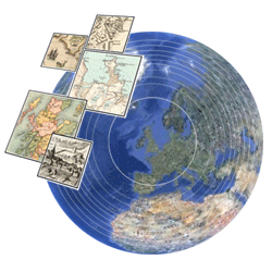
 The National Library of Scotland has just launched an exciting new application allowing their early maps of Scotland to be georeferenced and viewed in 3D as an overlay in Google Earth.
Georeferencing is quick and fun and allows historic maps to be directly compared to present day satellite imagery.
It’s a collaborative online project where anyone with access to the internet can help to georeference various historical maps from the NLS collection.
More information can be found on the NLS website.
maps
Visualising Urban Geographies
New dynamic maps of Edinburgh are now online through the National Library of Scotland’s collaborative Visualising Urban Geographies project with Edinburgh University. Included are 16 geo-referenced historical maps of Edinburgh from 1765-1940. They can all be compared together in Google Maps with present-day maps and satellite images. NLS have also created a 3-D representation of Edinburgh’s growth from 1450 to 1900 in Google Earth.
British geology maps now free to explore online
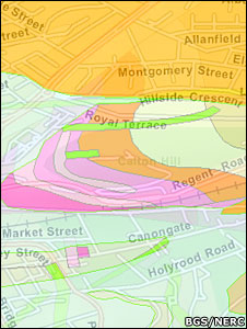
The British Geological Survey’s (BGS) new OpenGeoscience portal allows the public to study all the UK’s rocks on a simple Google map, down to a scale of 1:50,000. Toggling the map shows overlying towns and streets.
A range of educational and professional tools are also brought together on the website, including the huge national geological archive of photographs.
Tens of thousands of images have been amassed into the BGS library, showing different rock forms around Britain, fossil types, and the impact on the landscape of natural events such as flooding.
The whole archive is now searchable and free to use for non-commercial purposes.
The news is reported on the BBC website.