Historic Download – new service

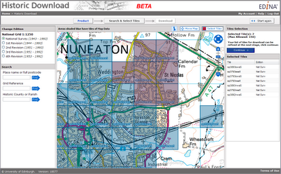
Launched as a BETA service on 20 April 2010, Historic Download is an entirely new facility allowing users to select and download larger quantities of historical map data.


The facility offers the capability to browse contemporary maps of the UK which have been shaded blue to indicate the coverage of historical maps of each series and edition. Areas of historical maps can be selected for download by clicking on the appropriate shaded polygons or by dragging a box to select multiple map sheets.

The interface has been designed to improve selection and retrieval of larger quantities of data for research projects. Build up a list of the data you need, choosing maps from different editions of a given product and take up to 200 maps in a single download.

EDINA welcomes feedback on this BETA service. You can contact us on edina@ed.ac.uk or 0131 650 3302.

Launching Ancient Roam

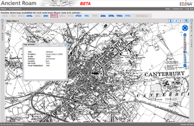
Ancient Roam is a new mapping facility within Historic Digimap. It is based upon the Roam mapping client available from Digimap’s OS Collection and includes the standard features such as fixed scale map views, ‘slippy maps’, searching by place name, postcode and grid reference, easy to use zooming and comprehensive help.


Key features specific to Ancient Roam include the ability to select historical maps from any decade (depending on map coverage and availability) using the Timeline along the top of the map window. Ancient Roam also offers an easier means of identifying and selecting maps in areas where County Series overlap at County boundaries. A single click on the map will also query maps to display the year the map shown was published along with other information about the map.

New Town Plan Maps
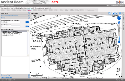
The large scale Town Plans are now available to view in Ancient Roam and download from Historic Download. The Town Plans are the largest scale historical maps available from Digimap offering great detail at 1:500, 1:528 and 1:1056 scales. The coverage of these maps is limited in that only settlements with a population greater than 4000 at the time of surveying were mapped. It is interesting to see what were regarded, then, as “urban” areas. The detail captured is enlightening; individual trees are marked in parkland and many industrial and commercial uses of land and buildings are noted.


Beta Service
Currently available as a BETA service, Ancient Roam will continue to undergo development over the coming weeks. Proposed additional functions include:

  • PDF map creation for printing
  • My Maps, to enable bookmarking screen maps for future reference
  • Multiple historical map views, to enable comparison of maps of different dates
  • Map fade slider, to show transition between maps of different dates
  • The ability to download the original Map sheet data which makes up your current on-screen map view


EDINA would welcome feedback on the service and on these proposed developments. Please contact us on edina@ed.ac.uk or 0131 650 3302

New Webinar Dates – online training

Some new webinars about Digimap have been posted on the EDINA events page:

http://edina.ac.uk/events/

These short sessions are available to any Digimap user, whether staff,
student or researcher.

Should the session times or content not be quite right for you, we will
happily set-up some alternative sessions.

You can contact us to discuss your training needs via the EDINA Helpdesk or you can call our Training Officer, Vivienne Carr, on 0131 651 1852.

OS OpenData

EDINA welcomes the release of Ordnance Survey datasets for free use and re-use. We are actively working to realise to the full the opportunities offered by this new policy for the enhancement and development of new and existing services for research and education.
As many will already know the Government published details on 31 March 2010 of the package of datasets and products from Ordnance Survey that are now available under OS OpenData – see http://www.ordnancesurvey.co.uk/oswebsite/opendata/. The list coincides partially with the datasets currently available through EDINA Digimap – see below. Note especially that OS MasterMap, the large-scale vector data, is only available through registration with EDINA Digimap.
The key task for EDINA Digimap is to provide ease and continuity of access to a whole range of geo-spatial datasets, including re-use in materials that are shared in research and teaching. We are therefore seeking clarification from Ordnance Survey regarding the licence terms that can now apply to the data available through Digimap which are now covered under OS OpenData.

The release of many Ordnance Survey datasets as open data is also good news for Unlock, the EDINA service which is there to help you geo-enable research data and other Internet-accessible documents and images. Unlock, and its predecessor GeoCrossWalk, were previously limited by license to academic use only. Relevant datasets now regarded as open data, including Boundary-Line, Code-Point® Open and the 1:50 000 gazetteer of place names, can now be used by Unlock Places, Unlock Text and Unlock Geocodes.
We are keen to learn from users of Digimap how you wish us to take best advantage of these changes in availability and licensing. Contact us by email on edina@ed.ac.uk or leave a comment on this blog.

Product Name EDINA Digimap OS OpenData
OS MasterMap Topography Yes No
OS MasterMap ITN Yes No
1:10 000 Scale Raster Yes No
nearest equivalent is OS StreetView
1:25 000 Scale Colour Raster Yes No
1:50 000 Scale Colour Raster Yes No
1:250 000 Scale Colour Raster Yes Yes
MiniScale® Yes Yes
Meridian™2 Yes Yes
Strategi® Yes Yes
Land-Form PANORAMA® Contours Yes Yes
Land-Form PANORAMA® DTM Yes No
Land-Form PROFILE® Yes No
Boundary-Line® Yes Yes
Code-Point® Yes No
CodePoint® with Polygons Yes No
Code-Point® Open
(point data only; subset of Code-Point®)
No Yes
1:50 000 Scale Gazetteer Yes Yes
OS StreetView No
nearest equivalent is 1:10 000 Scale Raster
Yes
OS Locator No Yes
OS VectorMap District
(from 1 May 2010)
No Yes

New Products added to Data Download

MiniScale and 1:250 000 Raster data are now available in Digimap’s Ordnance Survey Collection Data Download facility.

The datasets have been available from the ShareGeo service for some time, but are now also available from within Digimap. In addition to the new products you can now also:

  • download the OS Land-Form PROFILE, 1:10 000 Contour data in DXF format
  • download Shapefile and MID/MIF versions of Meridian2 data

The new Meridian2 formats have their own entry on the Product & Format page of Data Download. These formats are available as national coverage, with a single download covering the whole of Great Britain. The NTF and DXF formats are still available as individual tiles.

Land-Line style maps available in Carto

Maps of OS MasterMap data in Carto can now be styled to look like previous Land-Line.Plus maps. This is particularly useful for black and white printing or to recreate Land-Line.Plus data for comparison with older printed maps.

Training Reminder: Manchester and Nottingham

EDINA would like to remind you that booking is now open and there are spaces available on the following Digimap training courses, which are open to staff members in UK higher and further education institutions:

University of Manchester:

  • Guidance for site reps: 9 March 2010
  • Making maps in Digimap Collections: 10 March 2010
  • Downloading data from Digimap Collections 11 March 2010

Bilborough College, Nottingham:

  • Guidance for site reps: 7 April 2010
  • Making maps in Digimap Collections: 8 April 2010
  • Downloading data from Digimap Collections: 9 April 2010

You will find more details of course content and booking forms on EDINA’s Training and Events page . If you are uncertain about the relevance of a course for your needs, please contact EDINA for advice at edina@ed.ac.uk.

Changes to Digimap on 26 January

Yesterday, Tuesday 26 January 2010, some changes were made to Digimap. These are detailed as follows:

1. Classic removed from Ordnance Survey Collection.
As advertised on 5 October 2009 and 6 January 2010 this old facility has been removed and replaced by the new Roam facility. You can find a demonstration of Roam on the EDINA website: Roam demonstration

2. Historic Digimap “preview map sheet” button has been removed.
This function used out-of-date technology to render the original historical map sheets in the browser window. It was extremely slow and was dependent upon software installed on a machine which is being decommissioned. It is much quicker and more user-friendly to download the map sheet required and view it locally.

3. Marine Digimap Hydrospatial data updated.
The 2009 version of SeaZone’s Hydrospatial data is now available through Hydrospatial Download. Late delivery of the data has meant a delay of the release from September 2009 to January 2010.

MapAction – Haiti Appeal

MapAction is a a volunteer-based charity and non-governmental organisation which works in disaster zones providing frequently updated situation maps showing where relief help is most urgently needed.

The earthquake in Haiti has killed all but two members of the Haitian national mapping agency (the equivalent of Ordnance Survey). At Digimap’s 10th Anniversary event on 20th January 2010, Vanessa Lawrence, Ordnance Survey’s Chief Executive and Director General, took a moment to tell of the work that MapAction are doing in Haiti and encouraged donations to this cause.

Donations can be made online directly from the MapAction website: http://mapaction.org/.


ArcGIS and raster catalogs

The following may be of interest to those Digimap users who have ArcGIS 9.3.1 and are using raster catalogs.

ESRI have just released a patch fixing the issue with Microsoft SQL Server and Raster Catalogues. This works with ArcGIS 9.3.1 Service Pack 1.

ESRI’s announcement is as follows:

“ESRI announces ArcSDE 9.3.1 SP1 SQL Server Raster Catalog and Raster Field Patch. This patch addresses the raster catalog display and raster field identify problem for SQL Server following the install of 9.3.1 sp1. We recommend that all who store raster catalogs or raster fields in ArcSDE for SQL Server download and install this Patch at their earliest convenience to ensure the highest quality experience when working with ArcSDE 9.3.1 Service Pack 1.”

Link to patch🙁http://support.esri.com/index.cfm?fa=downloads.patchesServicePacks.viewPatch&PID=17&MetaID=1586)

Not getting emails?

We have recently noticed that some Hotmail accounts are rejecting emails from edina@ed.ac.uk as spam. This also includes emails which have been automatically forwarded to a Hotmail account from an institutional email account (.ac.uk).

This means that some users may not receive emails from which to download OS MasterMap data or their “Welcome to Digimap” registration confirmation.

If you believe you are not receiving emails from EDINA, please check that you have edina@ed.ac.uk in your Hotmail list of Safe Senders.