
The City beneath our Feet

Summary
This is an open toolkit that helps people observe cities from a brand-new perspective, allowing learners to discover the stories of the world beneath their feet through manhole cover rubbings. Learners will look for two or more safely accessible manhole covers and understand the significance of manhole covers as "nodes in the urban infrastructure network" by comparing their identification, location and function. Then, they will make a rub on one of the manhole covers and draw a simple "miniature underground network diagram" to speculate on the potential connections between these nodes. Finally, learners upload the rubbings and network maps to the class shared map, making their observations part of the urban network. If they wish, they can further mark the manhole covers on OpenStreetMap and participate in the joint construction of the public map.
The City beneath our Feet is a 20-minute open learning toolkit centered on Manhole Cover Rubbing.
“City Beneath Our Feet” is not merely about manhole cover rubbing(frottages) This technology was developed by Max Ernst in a blueprint drawn in 1925. https://www.tate.org.uk/art/art-terms/f/frottage
Max Ernst’s early “table rubbing” experiment saw the texture of wooden floors.
Place the paper on it for rubbing. The structure of the floor inspired him to place a piece of paper on it and then transfer its texture onto the paper with graphite.
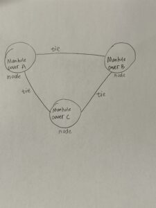
It is similar to the rubbing of manhole covers.It helps learners re-understand urban infrastructure through action – recognizing manhole covers as nodes of the underground network, and by finding multiple manhole covers and comparing them, inferences the hidden connections (ties) among them, thereby constructing their own “miniature urban infrastructure network map.
Materials Needed
- 2 to 3 sheets of A4 or larger paper (slightly thicker paper is preferred)
- Pencils or crayons (color is not limited)
- Tape (for fixing paper)
- Mobile phone or camera (optional, for taking photos and sharing)
Learning Goals
Steps
Step1
Step2
Step3
Step4
Step5
How do you understand the “connectivity” of a city through actions?
Take a photo of your print, note the city and date, and share it under the CC BY Open license to let more people see the city beneath their feet
Step6
If you want to explore further, you can mark the location of the manhole covers you find on OpenStreetMap (a completely free and open world map).
This way, we can jointly create an “underground network map” Each marker is a node. After everyone contributes, we can see how the city is connected.
This is the image uploaded by the author on openstreetmap, which can be found.https://commons.wikimedia.org/wiki/File:Rubbing_steps.jpg
https://commons.wikimedia.org/wiki/File:Tie_and_node_relationships.jpg
Open https://www.openstreetmap.org
Log in/register a free account
Zoom in on the map to your location
Click “Edit → Add a Point”
Name: “Manhole Cover – Rubbing Project (#CityBeneathOurFeet)”
Upload your rubbing photo (optional)
In this way, everyone can build a city network map together.
Further Resources
What is Frottage? (Tate Museum)
Max Ernst’s Frottage Works (Museum link)
What are “nodes and ties”? (basic network glossary link)
What is CC BY?(Creative Commons link)
The city beneath our feet © 2025 by Menger Yuan is licensed under CC BY-NC-SA 4.0
(https://commons.wikimedia.org/wiki/File:Rubbing_steps.jpg)
(https://openverse.org/image/207b3049-1c0a-41c7-8843-e6e27431e59c?q=Manhole+cover&p=4)
(https://commons.wikimedia.org/wiki/File:Rubbing_steps.jpg)
(https://commons.wikimedia.org/wiki/File:Tie_and_node_relationships.jpg)
(https://commons.wikimedia.org/wiki/File:Tie_and_node_relationships.jpg)
