Any views expressed within media held on this service are those of the contributors, should not be taken as approved or endorsed by the University, and do not necessarily reflect the views of the University in respect of any particular issue.
Digimap is an online map and data delivery service, available by subscription to UK Higher and Further Education establishments. Operated by EDINA at the University of Edinburgh, Digimap offers a number of data collections, including Ordnance Survey, historical, geological, aerial photography, LiDAR, marine maps, land cover mapping, global mapping and census data. For more information about Digimap go to our website: https://digimap.edina.ac.uk Background image Contains OS data (c) Crown Copyright and database right 2022
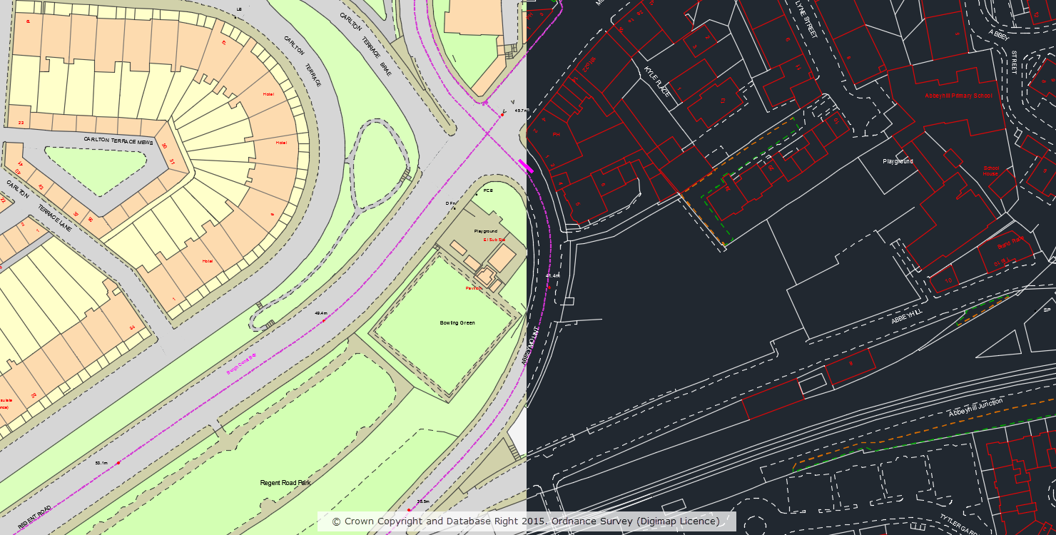
We have been hard at work developing a fresh new look for Digimap which we will be launching for the new academic year. Here is a sneak preview, though please note that nothing has been finalised just yet:
The operation of the page remains the same and the layout is almost identical, we have just given it a modern fresh look. We hope you like it!
If you have any questions or require any more information then please feel free to contact us:
A number of datasets in the Ordnance Survey Collection have been updated in May this year. We’ve also made a number of improvements to some of the datasets that are popular for 3D modelling which will hopefully make it easier to use these datasets in CAD applications. The main changes are:
OS MasterMap Sites Layer now available in DWG and ESRI Shapefile format (previously it was only available in GML)
OS Terrain 5 DTM is now available in XYZ format for use in CAD applications
OS Terrain 5 Contours in DWG format are now provided as as 3D contours with the height of each feature set to the correct contour height
The data format help page has been updated to reflect these changes and is a good place to go if you are interested to see which datasets are available in a specific format.
The dataset updates are detailed in the tables below for OS Data Download and OS Roam:
OS Data Download:
Product Name
OS Publication Date
Boundary Line
May 2016
* OS Locator
May 2016
OS Terrain 5 Contours
April 2016
OS Terrain 5 DTM
April 2016
OS VectorMap Local Raster
April 2016
OS VectorMap Local
April 2016
OS Open Roads
May 2016
Code-Point Open
May 2016
* Note: this is the last update to OS Locator that will be supplied by Ordnance Survey who have announced that they are retiring this product. Users are advised to use OS Open Names instead. Whilst the data will still be available to download through Digimap, these products will no longer be updated to reflect changes in the real world.
A number of datasets have been updated in January in both the Ordnance Survey and Marine collections.
We reported back in December that the new ‘No Marginallia’ version of SeaZone HydroView Charts were available to download through Marine Download. Since releasing this new version we have seen nearly 15% of downloads now requesting the new ‘No Marginalia’ version, which is great to see. Hot on the heels of this we have now made this new version available in the new Chart Roam application, which replaced Marine Maps. The ‘No Marginalia’ version was ideal for use in Chart Roam as the removed map marginalia means the charts are ideal for use in the slippy map interface in Chart Roam.
The tables below lists all the datasets that have been updated in each collection together with the publishing date for each one.
Ordnance Survey Roam
Product Name
OS Publication Date
1:25,000 Scale Colour Raster
December 2015
1:50,000 Scale Colour Raster
December 2015
OS VectorMap® District
September 2015
Ordnance Survey Data Download
Product Name
OS Publication Date
1:25,000 Scale Colour Raster
December 2015
1:50,000 Scale Colour Raster
December 2015
Points of Interest
December 2015
OS Open Names
January 2015
Chart Roam
Product Name
SeaZone Publication Date
HydroView Charts
August 2015
If you have any questions about the dataset updates or Digimap please contact us:
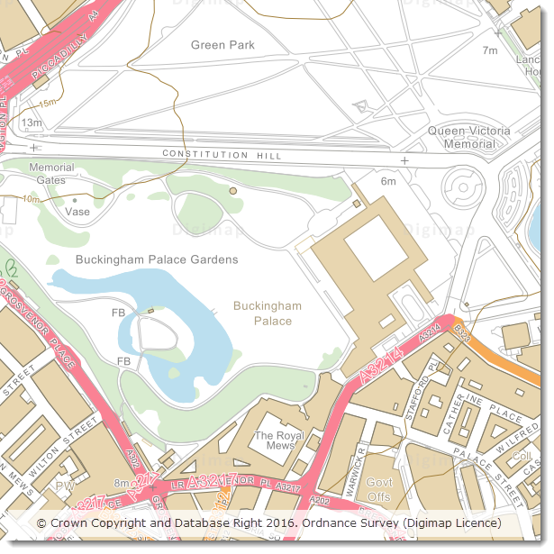
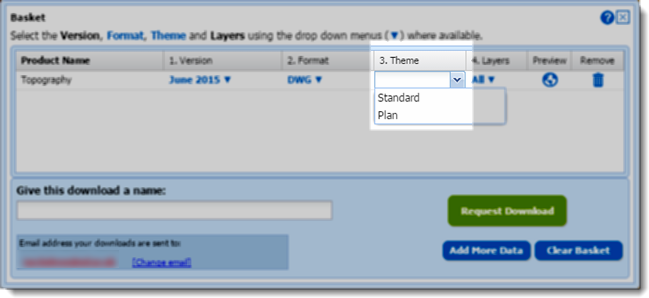
In April 2015 we made OS MasterMap Topography Layer data available to CAD users in DWG format. If you missed the announcement you can read all about it in this blog post. Since adding this option to Digimap we have processed over 13,000 orders for MasterMap in DWG format. Building on this we have now produced an outline ‘Plan’ style of MasterMap in DWG format which is a stripped down representation that mimics the alternative ‘Line Drawing’ style of MasterMap available in the Digimap Roam application.
OS MasterMap Topography Layer in standard and plan style
The alternative ‘Plan’ style is a cut down version of the full dataset and does not include polygons, users requiring the full dataset should download the original ‘Standard’ style which includes both lines and polygons.
The style is specified in the basket window of the Data Download application using the drop-down in the ‘Theme’ column:
Selecting DWG plan style in the basket
We hope you find this new style useful, if you have any questions or suggestions for further improvements please contact us:
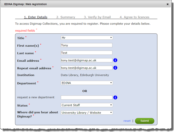
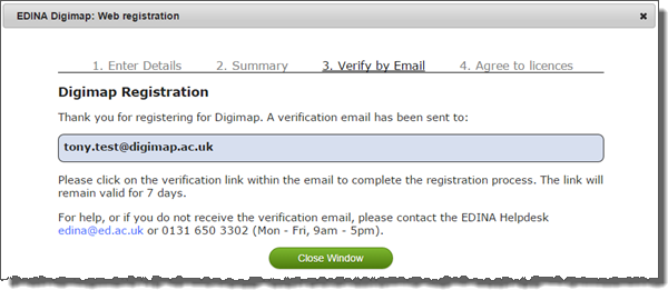
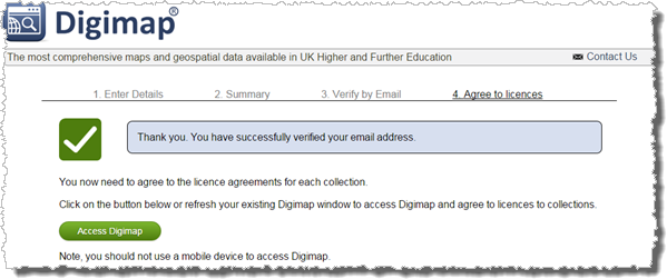
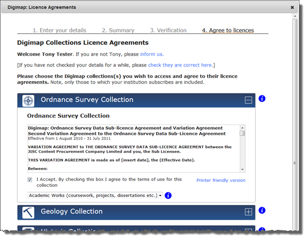
Digimap’s new registration system was released on the 28th of January, we hope you’ll agree that it is a huge improvement over the previous version.
Users no longer have to wait up to 48 hours for registrations to be approved, they simply have to click a link in an email sent to them after filling in the registration form.
It already has its fans leading one site rep to say “I love the new registration system!” and another told us “Congratulations on instant registration for students. This is going to be very popular.”
The new instant access system is much more inline with user expectations from online services. Removing the need to wait overnight (or longer over weekends) to gain access has been very popular and has resulted in a significant increase in registrations during February. Over 6000 registrations were processed through the new system at all times of day and night!
We now need your help to make sure that the support material at your institution is up-to-date and that your students know that they can have access to the service the same day.
There is a full description of how to register using the new system in the help pages which guides you through the process:
If you are responsible for any local support pages, lecture notes, practical guides and any other course material please make sure these get updated. We actively encourage the incorporation of the images and text from the help page in any material produced. Please can you circulate this information as widely as possible to ensure that all users have up to date guidance.
One final plea is that you highlight the importance of entering the correct email address when registering. This should be an email address that is used regularly and it should be spelt correctly!
As blogged about last month, we have been working on a new Digimap registration system which will be released next Wednesday (28th January) The current registration system has been in place for over ten years. It has served us well, but it is now rather dated especially because users have to wait for their registration to be manually approved and processed overnight. The new registration system allows users to get instant access to Digimap. This will be a significant improvement and help those students that leave their Digimap coursework a bit late! At least now they will be able to get access quickly and easily (unfortunately we can’t guarantee they’ll get the work submitted on time though!) Detailed help pages will be available from Wednesday, once the release has been completed and Digimap is available to users. To help prepare site reps and support staff for the change, here is an overview of the registration process. Registering with Digimap Registration will now be an automated two-step process. Users will supply their details to register and then they must activate access to collections by agreeing to the individual licences. After logging into Digimap to start, users will be presented with the registration form to enter their name, email address, department, status and where they heard about Digimap. After hitting the submit button, users will be sent an email with a link to verify their account. Once they have successfully verified, they will be directed back to the Digimap homepage, where they then complete the next step of activating collection access. Agreeing to licence for Digimap collections (activating access)After verifying their email address, users will need to agree to the licences for each of the specific Digimap collections that they wish to use, this is done through the licence agreements page. Users will only be able to agree to licences for the collections that their institution subscribes to. Once the user has agreed to the licence(s) and hit the confirm button, they will have access to those Digimap collections. If the process is completed in one go, it takes no more than a few minutes. Much quicker than the current system! Existing users Existing users will not notice any change unless they have not been active in a collection for more than 12 months. Access to a collection expires after 12 months of inactivity. If that’s the case, they will be prompted to accept the licence when they try to access an application in that collection. Generally though, if someone has not accessed a particular collection for more than 12 months, we don’t expect they will activate access and therefore will not notice any change with the new system. Access to active collections will carry on as normal. If you have any questions or comments, please contact the EDINA Helpdesk at edina@ed.ac.uk
We are introducing a new registration system in January (26th to the 28th) and would like to give advance warning of the service disruption this is will cause.
New users will not be able to register for Digimap from 4pm on 26th January
All Digimap services will be unavailable all day on 27th January
Normal service will resume on 28th January
New registrations for Digimap, using the current system, will be closed from 4pm Monday 26th January to ensure that no registrations are lost during the changeover. All Digimap services will then be unavailable all day on Tuesday 27th January, while we put the new system in place. Once all the work is complete the service will be available again hopefully by midday on Wednesday 28th January.
We apologise for the inconvenience caused but due to the significant changes required to release the new system we must close access to Digimap during this time. We urge you to create any maps or download data that you may need during the period of service unavailability in advance.
The new registration system will allow users to register and instantly access Digimap Collections via email verification speeding up access for new users significantly. We hope that this will help make up for the fact that new users will be prevented from registering during the maintenance. Existing registered and active users will not notice any change once normal service has been resumed.
If you have any questions or concerns please contact us:
Email: edina@ed.ac.uk
Phone: 0131 650 3302
More details about how the new system looks and works will be posted on the Digimap blog in the New Year.
October is the busiest time for welcoming new users to Digimap and we have already approved over 7500 registrations. As you know it is important to enter a valid email address when registering; this is how we send you a link to your data downloads and how we inform you of any changes or disruptions to the service.
We ask you to give us your academic email address where possible, we know for some this isn’t most commonly used address so please check that you have entered it correctly. Quite often the email address entered seems correct but is missing a particular element, for example:
We get: j.bloggs@university.ac.uk
We need: j.bloggs@student.university.ac.uk
Please make sure that you don’t miss out any parts of the address, you can try sending yourself an email to see if it is right… and it is always worth another check for typos.
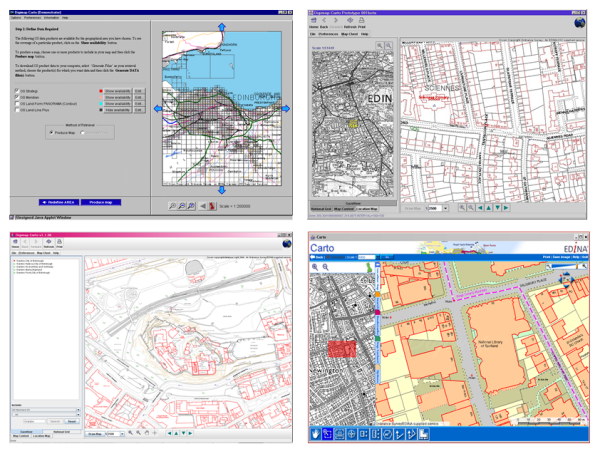
At 11:00 am access to Digimap Carto will be closed and by 12:00 noon it will have made its last map. Carto was at the cutting edge of web mapping technology for several years, delivering Ordnance Survey maps to thousands of users while Google was still just a search engine. The high quality EPS and then PDF print files it produced meant that staff, students and researchers could print out maps of anywhere in Great Britain and were no longer limited to their library’s collection.
Carto over the years 1998 to 2013
As time passed Carto could easily keep up with the latest offerings from MultiMap (later bought by Microsoft and eventually becoming Bing Maps) and Google Maps. It had more advanced tools and much better data in the form of OS MasterMap, so as the Java updates got more frequent we all put up with the software being a bit unreliable for a few days before we could issue a fix. However after 2011 the number of Java updates ramped up significantly and the changes became more difficult to accommodate. Once anti-virus software began seeing Carto as a potential threat and preventing it operating we decided that maintenance was unsustainable.
EDINA realised that continuing to support Carto would be too costly in terms of developer time spent fixing problems rather than improving and enhancing the service. In the meantime the rest of the world had become much more accustomed to viewing maps online in a web browser; EDINA’s other mapping service, Roam was able to take on much of what Carto was offering without confusing or frustrating its users.
Some recent changes to the capabilities of the web mapping platform that Roam uses meant that we could finally offer a Carto replacement without the need for any software to run on the end user’s computer. These changes have allowed us to withdraw Carto and let Roam to take on all the mapping duties for Digimap. We can now get on with the business of all those improvements and enhancements we have been wanting to make. We hope you will like the changes that we are aiming to have in place this August:
Geoforum aims to bring together staff who support the use of Digimap and other geoservices from subscribing institutions around the country and showcase what’s new and upcoming from EDINA. It also gives people an opportunity to ask the Digimap team questions and to chat with others about how support and promote geoservices.
There was a live blog running throughout the day which is still available for you to read and find out what happened.
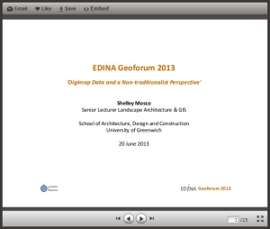
Keynote Address
The keynote was delivered by Shelley Mosco of The University of Greenwich and was titled: Digimap Data and a non-traditionalist approach. Shelley is a member of the The School of Architecture, Design and Construction and described the ways in which spatial data could be used to inform design. Shelley was keen to stress the importance of spatial data and GIS in the implementation of Building Information Models (BIMs). BIMs have been used in large engineering projects for some time, however the government is making them mandatory for all publicly funded building projects in England and Wales. This means that commercial organisations will be looking for students to have been trained in the concept of BIMs and the software that drives them. You can find out more about BIMs through the following links:
BIM Task Group – government site promoting best practise for BIM
COBie – Construction Operations Building Information Exchange
Two of Shelley’s current MSc students also gave brief overviews of their experiences of learning about GIS and using spatial data in their projects. Both David Parfitt and Robert Park were self-confessed GIS newbies, but they managed to get data from Digimap and use it in their conservation projects. The data allowed them to visualise and analyse the environment and provide evidence to support their proposed designs. Their demo’s were excellent a they really showed the power of simple GIS analysis.
You can view the slides from this presentation here:
After the Keynote was a presentation that focused on Open or “Free” resources for geospatial teaching and research. The presentation looked at software, web-mapping and data. The main resources are listed below:
Data
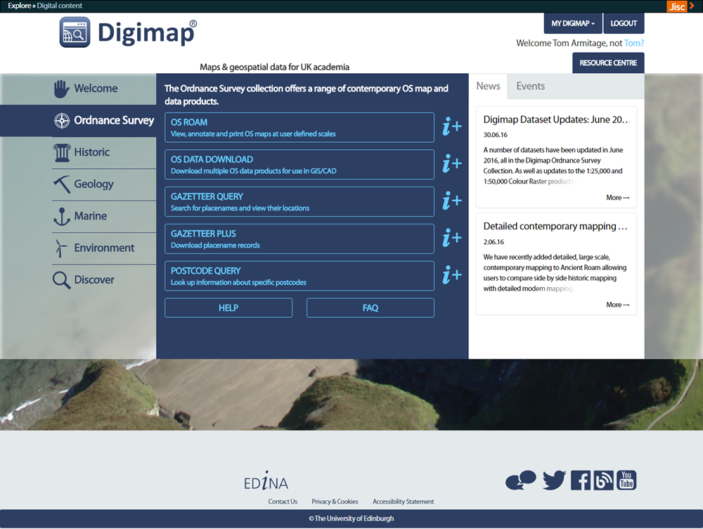
OS Open data is available through the Digimap Data Download service.
ShareGeo Open is a repository for open geospatial data. It has lots of useful and interesting datasets on a variety of subjects such as wind farms, crime, boundaries and DTMs
QGIS – one of the best open source GIS out there. Lots of functionality and plugins that allow you to perform complex spatial analysis. It is also well supported by forums.
GRASS – a remote sensing package aimed at serious remote sensor’s. If you are a newbie to remote sensing, you can access GRASS tool through the GRASS plugin for QGIS which makes things really simple.
Web-mapping
Digimap is a great web mapping tool, but how can you create your own interactive web map for your website?
MapBox – simple intuitive web site that helps users build interactive web maps. Basic functionality is free, more advanced functions are available for a small fee.
Leaflet – the engine behind MapBox, it is free but requires user to do a “bit” of programing
Openlayers – an alternative to Leaflet which is more flexible. Openlayers powers Digimap. Requires a fair amount of programming knowledge.
MapServer – implements Openlayers for enterprise scale operations. MapServer is also used for Digimap services.
You can view the slides from this presentation on slideshare here:
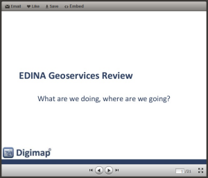
After lunch the lead of EDINA’s geoservices Support team, Emma Diffley, shared what we have been busy working on.
Interfaces
Digimap is being streamlined, each collection will eventually have just a Roam and a Download. These interfaces will all look and work in a very similar way. The aim is to make the service more consistent and easier to use, but also much easier to maintain.
EDINA will be withdrawing Digimap Carto on 31st July 2013. Carto, launched in 1996, is harder and harder to maintain, so we have taken the best bits and put them into Roam.
On top of the Carto functionality already added to Roam the following improvements are coming soon:
an improved way of saving and opening maps and annotations
a Basemaps button to change the style or even mapping product you are viewing at each scale
The Download interfaces will also going through a similar process.
Data
A single consistent style for all the vector products through all the scale levels accessible through using the basemaps button in the new Roam.
VectorMap Local (VML) in shapefile and DWG formats
ArcGIS layer files for symbolising VML shapefiles coming soon
OS MasterMap Topo available as DWG is being planned
Support
There is a new Resource Centre, which does not require login, with answers to questions, videos, case studies etc.
Beyond Digimap
GoGeo has added more resources and now highlights the “Editor’s Picks”
ShareGeoOpen now has over 210 resources all of which are open and free to use
FieldTrip GB is a mobile app for capturing data, see below
GeoTagger – a tool to allow you to edit the metadata for your photos
Cartogrammar – upload your data and visualise it in different ways
UKBORDERS is now the UK Data Service Census Support Unit
On the horizon
We are still awaiting news on funding, but are lots of things we would like to do. Currently our focus is to “mobilise” more services and we will be continuing to add new support materials once the latest round of Roam and Download changes have been made.
If there are things you would like us to do we really want to hear about them. Recommendations from the user community carry real weight for us, and we are keen to hear ideas on new data or services we should be providing.
You can view the slides from this presentation here:
The final part of the day was about EDINA’s new mobile app for carrying out field work Fieldtrip GB. It simplifies the process of capturing data in the field against quality cartographic mapping. It is equally at home in urban environments as it is in rural ones. Custom forms allow users to design their own data capture projects and collect exactly what they need for their research. The session gave a brief overview before running a “live” group data collection exercise. A custom form was created and deployed to participants mobile phones. They then headed outside and captured data on things like building fabric and design. After 15 mins everyone reconvened and the collected data was “synced” and exported to Google Earth.
You can view the slides from this presentation on slideshare here:
As mentioned earlier, there is a transcript of the whole day in the form of a live blog so if you didn’t manage to attend and want to find out what happened please have a look.


 EDINA’s Geoforum 2013 was a great success with over 50 academic and support staff attending four very well received presentations: