Any views expressed within media held on this service are those of the contributors, should not be taken as approved or endorsed by the University, and do not necessarily reflect the views of the University in respect of any particular issue.
Digimap is an online map and data delivery service, available by subscription to UK Higher and Further Education establishments. Operated by EDINA at the University of Edinburgh, Digimap offers a number of data collections, including Ordnance Survey, historical, geological, aerial photography, LiDAR, marine maps, land cover mapping, global mapping and census data. For more information about Digimap go to our website: https://digimap.edina.ac.uk Background image Contains OS data (c) Crown Copyright and database right 2022
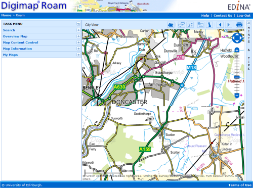
For those of you using Internet Explorer (IE) version 10, you may have noticed that the maps in Roam can get muddled up. This browser is standard for Windows 8 and is also available as an upgrade if you are using Windows 7.
The error is caused by the underlying technology EDINA uses to put the maps into your web browser. A patch for the particular piece of software that causes the issue has been released and we are now working to incorporate this into Roam.
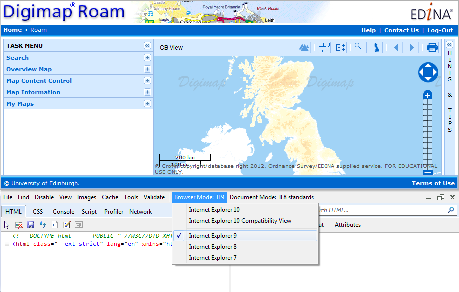
Until this fix has been released you can prevent the error from occurring by switching IE 10 to run in IE 9 mode. To do this simply press F12 on your keyboard when you are using IE 10 and change the Browser Mode: to Internet Explorer 9. The image below shows how this is done:
Click the image to enlarge it.
This issue affects all the different Roam mappers, Digimap, Ancient, Geology and Marine, however all will be fixed by making the change to the browser mode.
If you have any questions about this or any other issue with the Digimap services then please get in touch:
EDINA has added some more OS OpenData products to its Data Download facility. The new products are:
OS Terrain 50™
OS VectorMap® District Raster (Full Colour)
We have also updated the OS VectorMap District and OS VectorMap District Raster (faded colour) datasets from the beta version to the first full release.
OS Terrain 50 is currently only available as a DTM, as soon as the contours are made available we will add them to Data Download.
The list of OpenData products available from Data Download now consists of:
OS Street View
OS VectorMap District
OS VectorMap District Raster
Meridian 2
Strategi
1:250 000 Scale Colour Raster
Miniscale
Boundary-Line
Code-Point Open
Land-Form PANORAMA
OS Terrain 50
OS Locator
1:50 000 Scale Gazetteer
Why get OS OpenData from Digimap?
Digimap’s Data Download allows you to get OS OpenData in much smaller amounts than downloading it from Ordnance Survey’s website. You can take just the tiles that cover the area you are interested in, avoiding downloading large amounts of data you don’t need.
Data Download lets you take Licensed and Open data products at the same time which can save a lot of time when collating data for a project.
Data Download keeps the older versions of the datasets allowing you to see how the dataset changes over time. This is very useful when studying temporal changes though do note that not all changes on the maps are due to real word changes. Sometimes differences in survey techniques, accuracy or policy mean that new features appear or disappear from the map.
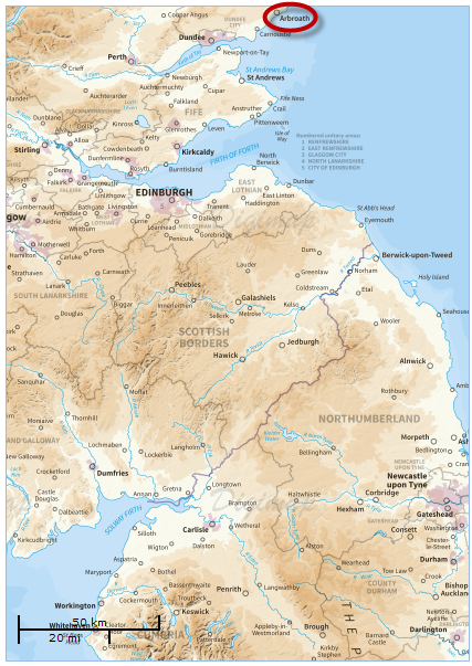
Log in to Digimap and click on Roam in the Ordnance Survey Collection.
Use the slider bar in the upper right corner of the map to zoom in once to show the National View. Don’t change the position of the map itself.
Click the Print button on the top toolbar (top right hand corner)
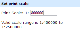
Set the print scale to 1:1.1 million (1:1100000)
Choose A0 portrait and an appropriate format from the drop-down lists (PDF will generate reasonably quickly)
Now click-and-drag the preview map directly upwards (north) so that Arbroath (shown on the east coast of Scotland) is at the very top edge of the preview map.
Click Generate Print File
The resultant file in PDF format will be around 2.9MB
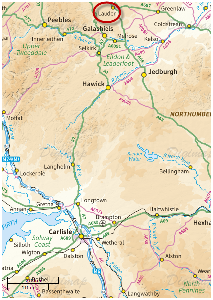
If you prefer to use a different map product, you could use the following variations on the above instructions:
Zoom in twice on the map using the slider bar (to view the County View map). Again, don’t change the location of the map.
In the print interface, set your scale to 1:1,100,000 and your paper size to A0 portrait, as previously
Now drag the map northwards so that the town of Lauder sits just below the top edge of the preview map.
This file in PDF format will be around 11MB
These instructions may need some minor alterations depending on your monitor resolution. You may find you need to drag the map either a little more or a little less further north in order to see both Shetland and the Scilly Isles on your printed map.
Booking is now open for the EDINA Geoforum Event on the 20th of June at the Congress Centre, London. All the details including a provisional programme are on the website: http://edina.ac.uk/events/geoforum2013/
It will be an all-day event with workshops, hands-on demonstrations and talks showing you what we are working on. We are very keen to hear your views about the next generation of Digimap services; so we would like you to join us and share your ideas.
Geoforum is a great opportunity for you to discuss any issues with the EDINA team and to network with geospatial people from across academia. We are aiming to provide more time and space for discussion and debate at this year’s event.
We have introduced a raft of new print options to Digimap Roam; some of these were previously only available in Carto, others are new altogether:
– Select your own scale for the printed map (within sensible limits) – Print OS MasterMap at up to 1:100 scale (Carto’s limit is 1:500) – Print at paper sizes up to A0 – Print landscape or portrait orientations (not available in Carto)
The new print options along with the formats already available mean that printing from Roam is now more flexible and powerful than Carto.
We have also added an extra zoom level to Roam’s screen maps called Building View. This shows OS MasterMap at around 1:500, making it easier to add detailed annotations such as new buildings to your map.
With these enhancements Roam can now perform many of the tasks previously only possible with Carto.
Unfortunately, Carto has become difficult to maintain and needs to be replaced. These changes to Roam, along with some extra features planned for the coming months, will enable it to take the place of Carto. Once all the enhancements to Roam are made we will retire Carto completely; we intend to do this at the end of July 2013.
If you have any concerns about the withdrawal of Carto then please let us know:
Marine Roam is a fantastic service which provides access to SeaZone HydroSpatial data for the waters around Great Britain. There are many applications for the data and the expanding offshore renewables sector, and associated research around it, immediately springs to mind. However, did you know that you can use Marine Roam for some historical sleuthing?
70 years ago today, 27th march 1943, HMS Dasher was sailing up the Firth of Clyde heading for Greenock. HMS Dasher had been converted into an aircraft carrier and was home to 8 Swordfish and 2 Sea Hurricanes. The planes were being refuelled following landing practice when there was a series of massive explosions. The ensuing fire could not be contained and the ship was abandoned. It sank just 6 minutes after the first explosion. While 149 seamen were recovered, 379 lost their lives.
Wrecks are marked in the HydroSpatial data and can be queried in Marine Roam. It is a little tricky to find the wreck of HMS Dasher. I knew it was situated in the Firth of Clyde, mid-way between Arran and the mainland, about 5 miles south of Little Cumbrae. However, the only wreck I could find was that of the Antares, a fishing trawler which sank in 1990 after its nets were apparently snagged by a submarine. After a bit of hunting I found some strange boat shaped features, seemingly related to military wrecks which for the most part appear to have been sunk during exercises. One of these marks the resting place of HMS Dasher. Below is a screenshot of the attribute information held in the HydroSpatial data about her.
Wreck of HMS Dasher in Marine Roam
You can log into Marine Roam and use the Info Tool to explore features on the map. Alternatively, you can download the data through Marine Download and load it into a GIS for further exploration.
So what other famous ship wrecks can you find in Marine Roam? Why not post a comment with the coordinates of your favorite sea-floor find.
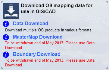
The functionality and datasets offered by MasterMap Download and Boundary Download are now available through the standard Data Download application. This can be found in the Download OS mapping data section of Digimap’s Ordnance Survey Collection.
This means that both MasterMap Download and Boundary Download will be withdrawn at the end of May 2013.
If you have teaching materials or course notes which are currently based on the old MasterMap Download and Boundary Download applications, please make sure you update them before these facilities are withdrawn.
If you have any concerns about this or any other issue then please contact us:
EDINA are planning to hold a Geoforum event on Thursday 20th June at the Congress Centre, Great Russell Street, London. If you support the use of Digimap at your institution or use it for teaching then you will want to keep the date free in your diary.
It will be an all-day event with workshops, hands-on demonstrations and talks showing you what we are working on. We are very keen to hear your views about the next generation of Digimap services; so we would like you to join us and share your ideas.
Geoforum is a great opportunity for you to discuss any issues with the EDINA team and to network with geospatial people from across academia. We are aiming to provide more time and space for discussion and debate at this year’s event.
Further information will be posted here on the Digimap blog and the EDINA Events page, including details of the programme and how to register: http://edina.ac.uk/events/
We have now put the datasets that were in MasterMap Download and Boundary Download into the Data Download facility. The datasets added are:
OS MasterMap® Topography Layer
OS MasterMap® ITN (Integrated Transport Network™) Layer
Boundary-Line™
Codepoint®
Codepoint® with Polygons
National Boundaries
National Grids
MasterMap Download and Boundary Download will continue to run until the end of May after which they will be removed from service.
You should find it quicker and easier to get the data you need from Data Download, and we have made it easier for you to come back and get updated versions or different formats too.
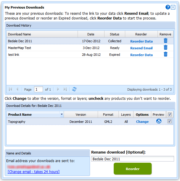
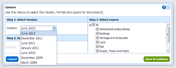
This functionality can be found in the My Previous Downloads section where you can also make a Change Only Update (COU) to your OS MasterMap data. See this blog post for more details:
Another big advantage of getting your OS MasterMap data from Data Download is that the interface allows you to select data from previous years, going back to 2009.
You can select an area, add MasterMap data from 2009, then use the Add more data button to include more MasterMap data from different dates. This is a great feature if you want to study how an area has changed over time.