Any views expressed within media held on this service are those of the contributors, should not be taken as approved or endorsed by the University, and do not necessarily reflect the views of the University in respect of any particular issue.
Digimap is an online map and data delivery service, available by subscription to UK Higher and Further Education establishments. Operated by EDINA at the University of Edinburgh, Digimap offers a number of data collections, including Ordnance Survey, historical, geological, aerial photography, LiDAR, marine maps, land cover mapping, global mapping and census data. For more information about Digimap go to our website: https://digimap.edina.ac.uk Background image Contains OS data (c) Crown Copyright and database right 2022
The Digimap team are hosting a free webinar, on Wednesday 26 April 2017, from 1-1:30pm.
3D model showing bedrock geology of the Cuillin hills in Skye with Aerial Imagery draped over OS Terrain 5 DTM.
The session will give an overview of how to create 3D models in common GIS and CAD packages (ArcGIS Pro, QGIS and AutoCAD) using data downloaded from Digimap.
The session will look at the datasets available from Digimap that are of use for 3D modelling.
You will also have the opportunity to ask questions on any aspect of Digimap.
Registration is required – please note that spaces are limited, so it’s advisable to register early.
Aerial Digimap was only launched at the end of last year but the response from the Digimap Community has been amazing. The service already has thousands of active users who have created hundreds of thousands of screen maps. Users have downloaded tens of thousands of square kilometres of this data, for use directly in reports or GIS and CAD software.
Data updates
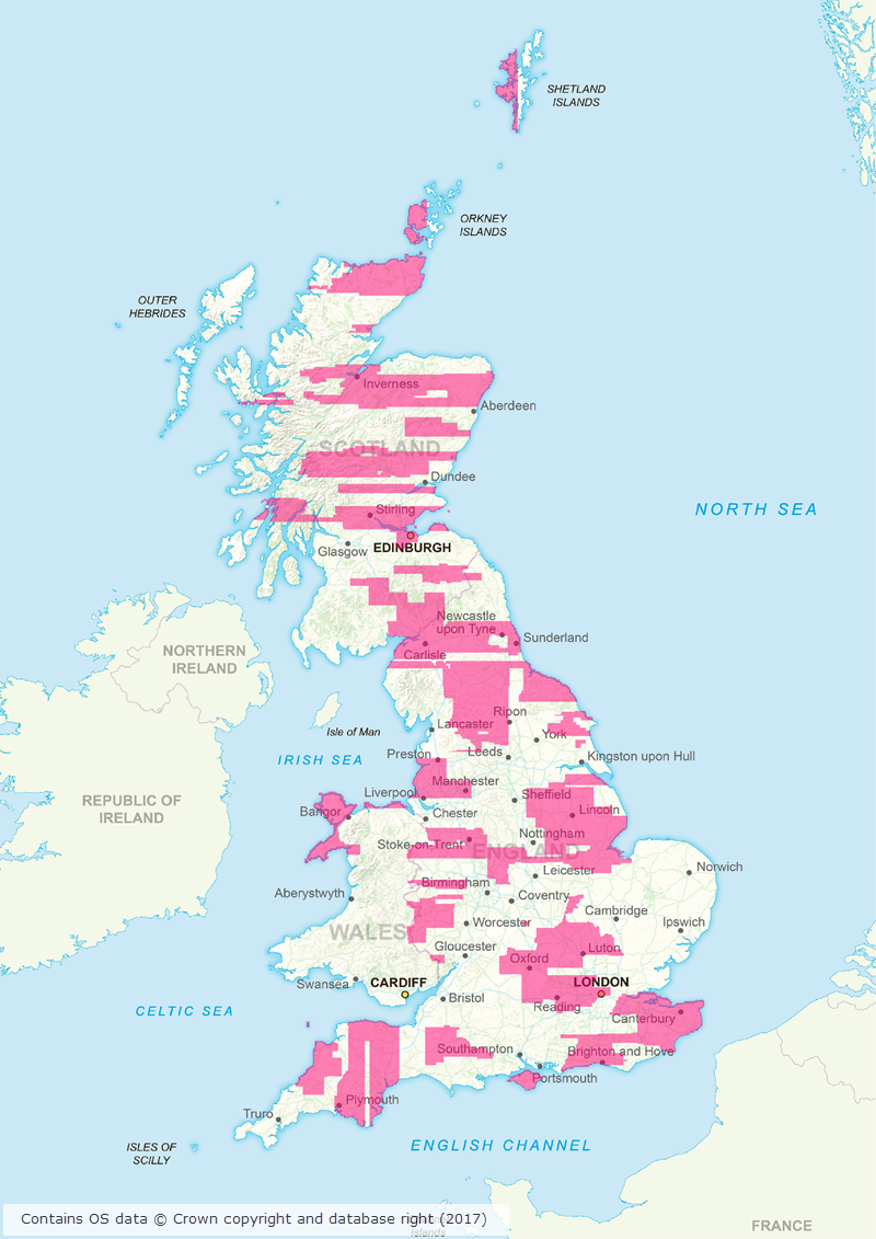
Whilst we’re excited to see such a high level of usage of the new service, behind the scenes our Data Team are currently processing the 2015 data which will be available in the service early next month. This is the first update we have received from the data supplier, Getmapping, and contains updates to around 80,000 tiles. This is a significant update as it covers roughly 30% of the country providing more up to date imagery for a large proportion of Great Britain. The map below shows the likely distribution of the updated 2015 data.
Click on map to view larger version
Webinar resources
We recently ran a webinar highlighting the data and showcasing a number of potential uses for the imagery. The webinar was recorded in full and is available on our YouTube channel. The slides used during the webinar and a transcript of all questions and answers are available on our help page.
3D model using Aerial Imagery, OS Terrain 5 DTM and MasterMap Building Height Attribute
Data information
The aerial imagery data in the service is 25cm resolution vertical aerial imagery supplied by Getmapping PLC, and is the most detailed aerial imagery available for the whole of Great Britain. As well as being a really interesting dataset the imagery also has a number of practical uses across a wide range of disciplines from urban planning and 3D modelling to land use and archaeological studies.
Subscribing
To see if your institution already subscribes to Aerial Digimap, please see our subscribing institutions help page. Information on how to subscribe to the new service is available on the Aerial Digimap Subscription page.
If you have any questions about the service please consult the dedicated Aerial Digimap help pages or contact the Digimap support team using the details below.
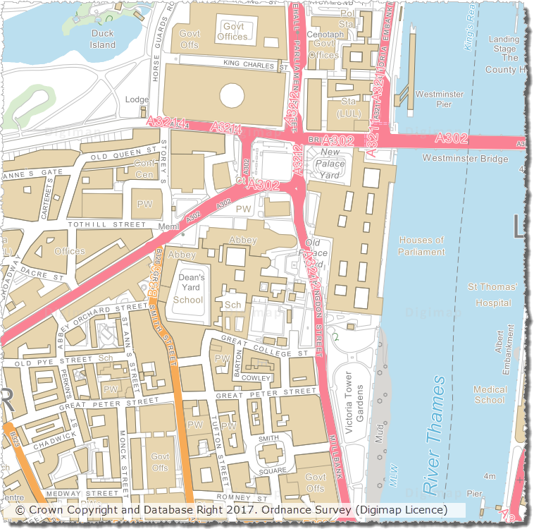
We have updated a number of key datasets in Jan/Feb 2017 in the Ordnance Survey collection of Digimap. These updates bring the datasets available from Digimap inline with the latest versions published by Ordnance Survey. Of particular note are the updates to the two most detailed mapping products available from Ordnance Survey: OS MasterMap Topography Layer and OS VectorMap Local.
OS VectorMap Local showing WestminsterOS MasterMap Topography Layer showing Westminster
OS Data Download:
Product Name
OS Publication Date
Integrated Transport Network (ITN) Layer
December 2016
OS MasterMap Topography Layer
December 2016
OS MasterMap Water Network Layer
January 2017
OS VectorMap Local
January 2017
OS VectorMap Local Raster
January 2017
MiniScale
January 2017
OS Terrain 5 Contours
January 2017
OS Terrain 5 DTM
January 2017
OS Open Names
January 2017
Code-Point with polygons
January 2017
Code-Point Open
February 2017
OS Roam:
Product Name
OS Publication Date
OS MasterMap Topography Layer
December 2016
OS VectorMap Local
Jan 2017
OS VectorMap Local Raster
Jan 2017
MiniScale
January 2017
The OS data update page is kept up to date with all dataset updates in the collections.
If you have any questions about the dataset updates or Digimap please contact us: