Roy’s Edinburgh Walks
List of walks
- 0. Edinburgh Strolls: 1- to 2-hour long strolls around places of interest in or near Edinburgh, all on quiet paths.
1. Edinburgh Circumnavigation Walk: 45-mile circular route (in five sections) around the outskirts of Edinburgh.
2. Lothian-90 Walk: 90-mile walking route (in nine sections) across the whole of West, Mid and East Lothian.
3. Stroll around Edinburgh: 35-km stroll (in five easy sections) around the quiet, outer area of Edinburgh.
4. Edinburgh’s five rivers: Almond; Figate/Braid; Bonaly/Dean/Swanston/Burdiehouse; Burdiehouse/Niddrie/Brunstane; Water of Leith.
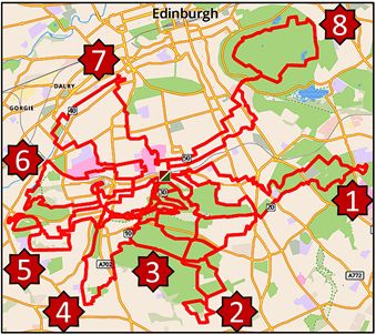
5. South Edinburgh: Eight short (5 to 7 mile) circular walks from Blackford Pond.
0. Edinburgh Strolls
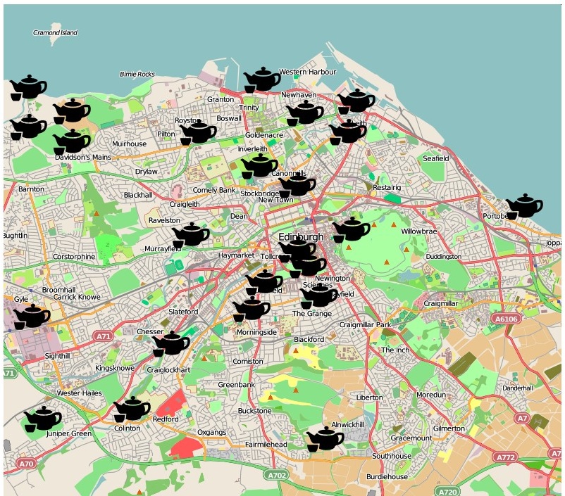
A series of short (themed) strolls. All strolls start and end at a café; all are located within Edinburgh or its suburbs; and all are easily accessible by public transport.
Maps, route decriptions and notes (yellow table below) allow self-guiding.
The strolls were devised (2023 onwards) for a local group (the Eu3a) in which members meet for a friendly get-together for tea/coffee (hence the tea pots on the city map) followed by a gentle 1-hour long stroll around a quiet area of interest.
Links to map, route description, and notes for individual strolls can be accessed from the table below.
| Location | Map | Route description | Highlights | Background information |
| Quartermile | Quartermile Map | Quartermile Route | Quartermile | Quartermile Background |
| Old Leith Docks | Leith Docks Map | Leith Docks Route | Leith Docks | Leith Timeline |
| Mortonhall | Mortonhall Map | Mortonhall Route | Mortonhall | Mortonhall History |
| Edinburgh Park | Edinburgh Pk. Map | Edinburgh Pk. Route | Edinburgh Pk. | Twelve Poets |
| Sciennes | Sciennes Map | Sciennes Route | Sciennes | Sciennes Heritage |
| Portobello | Portobello Map | Portobello Route | Portobello | Porty History & Photos |
| Botanics | Citizen Science | Citizen Sci. Route |
Phenology | Findings |
| Lasswade | Lasswade Map | Lasswade View | Lasswade | Lasswade & Kirkyard |
| North Morningside | Morningside Map | 1817 Map | Morningside | Napier and logarithms |
| Bonnington Mills | Bonnington Map | x | B. Mills | Historical Notes |
| Medieval & Old Leith | Leith Map | x | Medieval Leith |
Seven phases |
| Inverleith Park |
Inverleith Map |
x | Inverleith | Inverleith Park & Pond |
The Edinburgh Stroll routes can also be accessed at the Plotaroute website. There, for each stroll, a Dropdown Menu (top right) provides various extra features including: Route Info., Elevation profile, Directions, Zoom in and out (by tapping on the + and – buttons), Download using standard GPS formats (GPX; KML; TCX; FIT), Smartphone: use the plotaroute app to help follow the Strolls. (Tap on the Tracker icon in the bottom right to enter SatNav mode.), Animated Fly-Over of Stroll routes in Google Earth.
Map of potential future stroll routes:
1. Edinburgh Circumnavigation Walk
A 45 mile walk around the outskirts of Edinburgh and through its hinterland. The full circuit has been designed as a quiet, almost traffic-free, scenic route along quiet footpaths and lanes through outer Edinburgh and its ever-varied suburban, post-industrial and Greenbelt/rural hinterland.
1.a Brief summary of the full route
Leg 1 Linear from Ocean Terminal to Whitecraig, via Docks, Swing Bridge, Leith Links, Sewage Works, Portobello, Joppa, Musselburgh and River Esk.
Leg 2 Linear from Whitecraig to Bilston, via Dalkeith, Hardengreen, outskirts of Bonnyrigg, Springfield, Polton Mill and Bilston Burn.
Leg 3 Linear from Bilston to Colinton, via Pentland Grove, Cow Lane, Boghall, Hillend and Swanston.
Leg 4 Linear from Colinton to Cramond Brig, via Water of Leith, Wilderness Wood, Heriot-Watt, Union Canal, Hermiston Gait Shopping Centre, Edinburgh Park Station, The Gyle Technology Park, Braehead Recycling Dump, Cammo Estate and River Almond.
Leg 5 Linear from Cramond Brig to Ocean Terminal, via River Almond, Cramond, Silverknowes, Granton Point, Royston House, Granton Harbour, Primrose Bank, Newhaven, West Breakwater & Western Harbour. On reaching Ocean Terminal the 75km circuit of Edinburgh is complete.
Detailed Route Descriptions (legs 1, 2, 3, 4, 5)
Background Notes
Interactive Route Map Use zoom slider (top right) and click & drag to find route details.
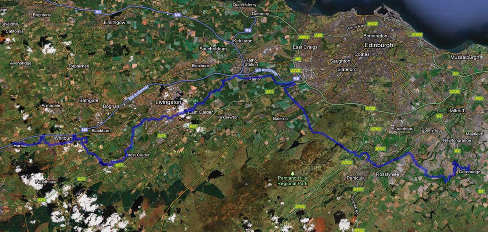
2. Lothian-90 Walk
A 90 mile walk (in nine sections) across West, Mid and East Lothian. The full traverse has been designed as a quiet, scenic route along quiet footpaths and lanes, with a minimal amount of roadside walking. All sections are easily reached by public transport.
Lothian-90 Route description (Legs 1 to 5)
Lothian-90 Route description (Legs 6 to 9)
Individual route map, elevation chart and short description for all nine sections
Lothian-90 Route (Leg 1)
Lothian-90 Route (Leg 2)
Lothian-90 Route (Leg 3)
Lothian-90 Route (Leg 4)
Lothian-90 Route (Leg 5)
Lothian-90 Route (Leg 6)
Lothian-90 Route (Leg 7)
Lothian-90 Route (Leg 8)
Lothian-90 Route (Leg 9)
Zoomable version of walk map [Legs 1 to 5: Harthill to Gorebridge] Use zoom slider (top right) and click&drag to find route details.
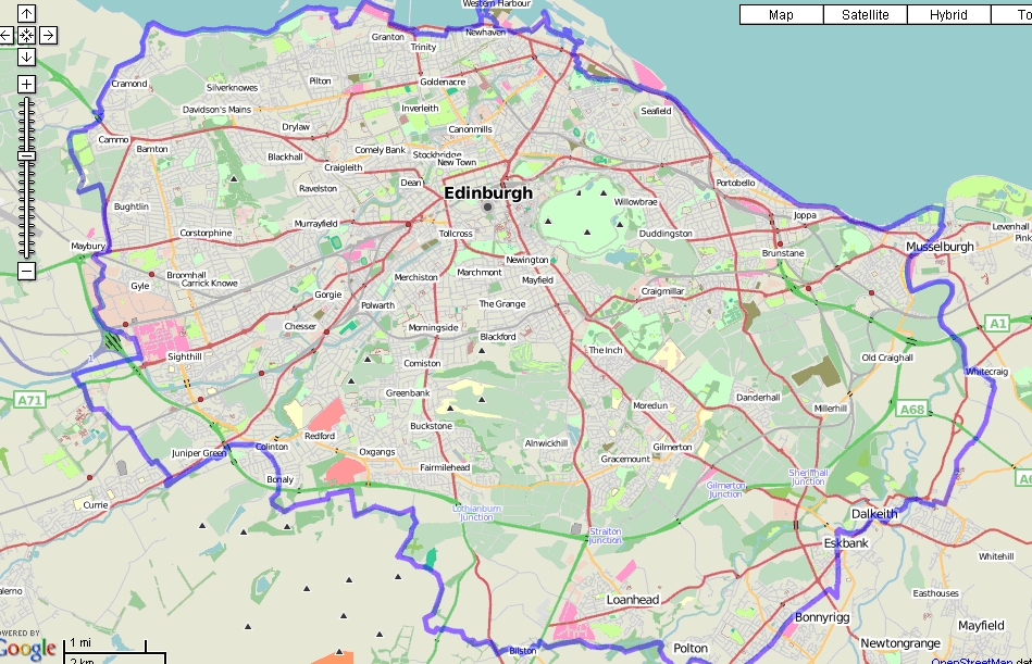
3. Stroll around Edinburgh
A 35 km stroll around the outer area of Edinburgh
A walk around the outskirts of Edinburgh. The circuit has been designed as a quiet, almost traffic-free, scenic along quiet footpaths and lanes through suburban Edinburgh.

Individual, detailed route descriptions for each of the five sections
Route Descriptions: All legs. 1, 2, 3 4 & 5
Background Notes
Urban sprawl: Quo Vadis Edinburgh?
4. Edinburgh’s five rivers: Source to Sea
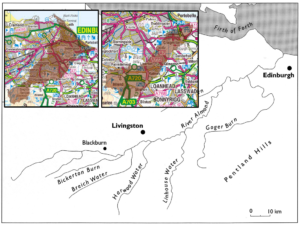
(i) River Almond
Shotts to Blackburn Description/Map
Blackburn to Mid CalderDescription/Map
Mid Calder to Kirkliston Description/Map
Kirkliston to Cramond (Includes Dolphinton/Cockle Burn) Description/Map
(ii) Figate/Braid Burns
Portobello to Firrhill – lower reaches of Figate and Braid Burns Figate Burn: Description/Map
(iii) Bonaly/Dean/Swanston/Burdiehouse Burns
Firrhill to Fairmilehead via Allermuir Hill – upper reaches of Bonaly/Dean/Swanston/Burdiehouse Burns Bonaly Burn: Description/Map
(iv) Burdiehouse/Niddrie/Brunstane Burns
Fairmilehead to the coast Burdiehouse Burn: Description/Map
(v) Water of Leith
Source and upper reaches problematic. No public transport, much barbed wire. Colzium springs to Balerno
Description and maps for middle and lower reaches: provided by www.walkhighlands.co.uk Balerno to Slateford Slateford to Leith
5. South Edinburgh. Eight COVID-19 inspired circular walks (5 to 7 mile) from Blackford Pond
- A Craigmillar Castle circuit
- A Mortonhall figure of eight
- Le Tour de Braids
- In the footsteps of RLS
- A war poets’ 4-loop walk
- A sweep past sixteen old curling ponds
- The Canal Basin
- Outlying tops of Arthur’s Seat
Exportable GPX file EightFromBlackfordPond for use in GPX Viewers (Created in Mapometer).
Comments are closed
Comments to this thread have been closed by the post author or by an administrator.