What is Digimap?

We have created a video that explains what Digimap is and what it can be used for.  Very useful for showing to people who might not see how the service could be relevant for their work.

[youtube width=”640″ height=”390″]http://www.youtube.com/watch?v=8NO8IqQohEU&hd=1[/youtube]

There is also a video about the GoGeo service which is a vital tool for anyone working with maps or Geospatial data:

[youtube width=”640″ height=”390″]http://www.youtube.com/watch?v=RtBZfv-Rjng&hd=1[/youtube]

Geology & Marine Digimap get Data Updates

Geology Digimap

Geology Roam and Geology download are now using the most up-to-date detailed geology map data:

  • DiGMapGB-50 Version 6.20, 1:50,000 scale data

Geology Data isn’t updated very often, and it is great to have the data refreshed for the new academic year. Version 6  has a few new tiles; there are now only 3 tiles of missing data in Wales, and there have also been a few tile updates elsewhere in the UK such as SC064 which has now been split into two regular sized tiles, SC064E Ben Macdui and SC064W Newtonmore.

There have also been some small changes to the attribution of the data  which is now at level 20.  The main difference is that each polygon now has a link to both the Lexicon of Named Rock Units and the Rock Classification Schema within it’s attributes. Digimap Roam already provided the key information via the Get Rock Info tool.

Marine Digimap

Marine Roam and Hydrospatial Download now benefit from updated Hydrospatial data. There are many updates to the features available and more layers area available across more tiles.

Digimap Ordnance Survey Data Annual Update

On the 13th of September we held the annual update of the maps and map data in Digimap. There haven’t been any major specification changes this time though you will notice some cartographic changes to the MiniScale maps in Digimap Roam.


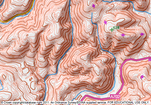
New MiniScale Cartography
© Crown Copyright/database right 2011. An Ordnance Survey/EDINA supplied service.

The Urban areas are now purple and on the more zoomed out maps there has been some enhancement to the relief shading.

All the following data products were updated to the latest version available:

  • MasterMap Topography and ITN Layers:
  • Meridian2
  • Strategi
  • MiniScale
  • Code-Point
  • Code-Point with Polygons
  • Boundary Line
  • 1:250,000 Colour Raster
  • 1:50 000 Colour Raster
  • 1:25 000 Colour Raster
  • 1:10 000 Raster
  • 1:50 000 Scale Gazetteer

All the products have been updated in Digimap Roam, Carto and all the different Data Downloaders. The following products were not updated as the versions were already the most up-to-date available:

  • VectorMap District
  • VectorMap Local
  • Land-Form PANORAMA contours and DTM
  • Land-Form PROFILE contours and DTM


Annotations Tools in Ancient Roam

Ancient Roam now has the annotation tools, so all the Roam facilities allow you to add your own features (symbols, lines, polygons and text) to the map.

Ancient Roam Annotation Tools

We are always looking for feedback so if you have any requests for symbols, line styles or any other features you would like put on the map, let us know. You can comment on this post or email us directly here:

Mailto: EDINA help desk

Remember there is a video on how to use the general features of the Annotation Tools on YouTube:

[youtube width=”640″ height=”390″]http://www.youtube.com/watch?v=PSkTZvMNyKU&hd=1[/youtube]

ESRI UK/CHEST Technical Event – 13th September, Edinburgh

The 2011 Esri UK and Eduserv Seminar will be taking place on 13th September at Surgeons Hall in Edinburgh. The event is a chance for Esri users from UK Academia to hear about the new Esri CHEST agreement which started on 1st August, as well as what’s coming in ArcGIS 10.1 and various presentations from members of the Higher Education community. Members of the Digimap team will be attending to present on using Digimap data in ArcGIS, we will also have a stand so if you are attending, come and talk to us!

The event is free to attend, but you must register at: http://www.cvent.com/d/0cqnc7

Information about the Chest agreement can be found at: http://www.eduserv.org.uk/lns/agreements/esri-2011#keyfacts

Digimap OpenStream updated

Digimap OpenStreamDigimap OpenStream, EDINA’s open WMS service, has been updated with the latest version of OS Street View from the OS OpenData collection. The latest version is from May 2011 and contains change-only updates.

EDINA aims to provide the latest version of OS OpenData via the OpenStream service. This means that datasets may be updated part way through an academic year.

For more information about OpenStream and to register click on the following link:

Digimap OpenStream

There are also YouTube videos on how to use OpenStream in ArcGIS and Quantum GIS:

OpenStream In ArcGIS

[youtube width=”640″ height=”390″]http://www.youtube.com/watch?v=LkZhnzxeJio&hd=1[/youtube]

OpenStream in Quantum GIS

[youtube width=”640″ height=”390″]http://www.youtube.com/watch?v=hCKE4KYuXVo&hd=1[/youtube]

Isle of Man Maps

Isle of Man
© Crown copyright/database right 2010. Ordnance Survey/EDINA supplied service.

Ordnance Survey isn’t the national mapping agency for the Isle of Man, however they do include it in a few of the mapping products they produce:

  • OS MiniScale,
  • 1:250,000 Scale Colour Raster
  • Strategi,
  • Land-Form PANORAMA,
  • 1:50,000 Scale Colour Raster

The easiest way to view the Isle of Man is to do a place name search for Douglas or anywhere else on the island in Digimap Roam. This will take you straight to the Local View, which uses the 1:50,000 Scale Colour Raster.  You can zoom out from this view and see maps at each scale level, though there are only contours in the District View as there is no Meridian 2 data to provide roads and other topography.

Unfortunately you cannot zoom in from the Local View as this is the most detailed mapping the Ordnance Survey have for the Isle of Man. If you need more detail then you will have to contact the Isle of Man Government:

http://www.gov.im/infocentre/maps.xml

All the Ordnance Survey mapping products mentioned above are available to download from Digimap; just go to the Data Download facility.

There is a good post on the Ordnance Survey blog which explains how all the different parts of the UK including the Isle of Man fit together:

The difference between UK, Britain and the British Isles

2011 Data Update

This year’s annual data update will take place at the beginning of September.  There will be a refresh the following Ordnance Survey products:

MasterMap Topo

  • MasterMap Topography and ITN Layers
  • VectorMap Local
  • Meridian2
  • Strategi
  • MiniScale
  • Code-Point
  • Code-Point with Polygons
  • Boundary Line

1:250,000 Colour Raster

  • 1:250,000 Colour Raster
  • 1:50 000 Colour Raster
  • 1:25 000 Colour Raster
  • 1:10 000 Raster
  • 1:50 000 Scale Gazetteer


There will also be updated Hydrospatial data in Marine Digimap and a new version of the DiGMapGB-50 data in Geology Digimap.

Along with the new data Ancient Roam will be getting the Annotation Tools and there may be a bit of a surprise bonus addition to Digimap Roam. More information will be posted on the Blog, Twitter and Facebook page nearer the time.

Annotation Tools in Marine Roam

Now we have the annotation tools up and running they are being added to all the Roam services thick and fast! Marine Roam is the latest to get the tools, again they are an initial version with the basic set of features.

Marine Annotation Tools

Please let us know if you have any requests for symbols, line styles or any other features you would like to be able to annotate the map with. You can comment on this post or email us directly here:

Mailto: EDINA help desk

Remember there is a video on how to use the general features of the Annotation tools on YouTube:

[youtube width=”640″ height=”390″]http://www.youtube.com/watch?v=PSkTZvMNyKU&hd=1[/youtube]

There is also a section in the How to use Marine Roam help page that covers how to use all the different tools: