Any views expressed within media held on this service are those of the contributors, should not be taken as approved or endorsed by the University, and do not necessarily reflect the views of the University in respect of any particular issue.
Digimap is an online map and data delivery service, available by subscription to UK Higher and Further Education establishments. Operated by EDINA at the University of Edinburgh, Digimap offers a number of data collections, including Ordnance Survey, historical, geological, aerial photography, LiDAR, marine maps, land cover mapping, global mapping and census data. For more information about Digimap go to our website: https://digimap.edina.ac.uk Background image Contains OS data (c) Crown Copyright and database right 2022
MiniScale and 1:250 000 Raster data are now available in Digimap’s Ordnance Survey Collection Data Download facility.
The datasets have been available from the ShareGeo service for some time, but are now also available from within Digimap. In addition to the new products you can now also:
download the OS Land-Form PROFILE, 1:10 000 Contour data in DXF format
download Shapefile and MID/MIF versions of Meridian2 data
The new Meridian2 formats have their own entry on the Product & Format page of Data Download. These formats are available as national coverage, with a single download covering the whole of Great Britain. The NTF and DXF formats are still available as individual tiles.
Land-Line style maps available in Carto
Maps of OS MasterMap data in Carto can now be styled to look like previous Land-Line.Plus maps. This is particularly useful for black and white printing or to recreate Land-Line.Plus data for comparison with older printed maps.
Yesterday, Tuesday 26 January 2010, some changes were made to Digimap. These are detailed as follows:
1. Classic removed from Ordnance Survey Collection.
As advertised on 5 October 2009 and 6 January 2010 this old facility has been removed and replaced by the new Roam facility. You can find a demonstration of Roam on the EDINA website: Roam demonstration
2. Historic Digimap “preview map sheet” button has been removed.
This function used out-of-date technology to render the original historical map sheets in the browser window. It was extremely slow and was dependent upon software installed on a machine which is being decommissioned. It is much quicker and more user-friendly to download the map sheet required and view it locally.
3. Marine Digimap Hydrospatial data updated.
The 2009 version of SeaZone’s Hydrospatial data is now available through Hydrospatial Download. Late delivery of the data has meant a delay of the release from September 2009 to January 2010.
New data
On Thursday 17th September EDINA released all available updates for data provided through Digimap’s Ordnance Survey Collection. Details of the versions of all the data offered can be found on the EDINA website here. The Digimap licence also now offers MiniScale and the OS 1:250,000 scale colour raster data. These are currently available through ShareGeo and will be added to the Data Download as soon as possible.
Architectural Changes
As well as updating the data, other significant changes have been made to the underlying technologies supporting Digimap. In short, we have replaced the entire GIS architecture which produces the maps you see online.
The new software, from Cadcorp, offers a number of benefits to both EDINA and end users of Digimap. As well as enhanced quality maps and faster map generation online, the printed output gives crisp, clear maps as PDF files. EPS files are no longer available from any facility within Digimap’s OS Collection, including Carto, but EDINA is working on the provision of additional formats to PDF.
New mapping facility: Roam
With the arrival of the new GIS software, EDINA has also developed a new mapping facility, called Roam. Still in a development phase, Roam offers the usual search functions as well as “slippy maps”, the click-and-drag function used to position a map, familiar to users of other popular online mapping facilities. It is easier to locate your map, easier to zoom in and out, and now offers maps at 12 different fixed scales. An additional small scale Ordnance Survey mapping product, MiniScale, has been included, and other datasets (e.g. Strategi and OS MasterMap) are available at more than one fixed scale.
Currently Roam is available as a Beta facility to site representatives only until Monday 5th October, when it will become available to all registered users of Digimap’s Ordnance Survey Collection. Roam is available from the OS Collection Home page; you will find the new icon next to those for Classic and Carto. It will be greyed out if you don’t yet have access to it.
Roam will run in Beta alongside the current Classic facility until January 2010 when Classic will be withdrawn entirely. Regular updates will be made to Roam to add new functionality, such as MyMaps, prior to its release as a full service in January 2010.
If you have any questions about this email or about Digimap in general, please do not hesitate to contact the EDINA Helpdesk on edina@ed.ac.uk
Check the date on which you created the original Order. If you created it after the last set of CoU was released but before the next set of CoU is released, then you already have the latest version of the data. If a release of CoU is imminent, you should wait until after the release date, and then check your data order for the availability of CoU.
I have downloaded CoU for my area, but having applied it to my existing data holding, nothing looks different. Why is this?
Not every feature changes every time a Change-only Update is released. It may be that none of the features in your data holding have been updated this time. It is not possible for EDINA to determine exactly whose orders contain changed features.
You may also find that there are some small changes to the attributes for your data. These are harder to identify if you are simply looking for changes visible on a map. It isn’t necessarily the geometry or position of a feature which has changed. When you plot the changes on a map, you may not see them, because the changes may relate to data in the attribue table.
Why can’t I have CoU for other datasets?
Only OS MasterMap data offers Change-only Update. This is because other datasets are not structured in a way which enables CoU to be identified and extracted separately. Other datasets are also not updated so frequently.
The next release of Change-only Update data for OS MasterMap will be put into service on Tuesday 24 March 2009. The currency date of the new data will be 20 January 2009.*
Change-only Update (CoU) applies only to the OS MasterMap data. It does not apply to any other data product.
EDINA collates all the data changes released by Ordnance Survey over a 6-month period, and makes these available through Digimap approximately every 6 months. The previous update was released in September 2008.
What is the point of Change-only Update?
Change-only Updates enable you to update your data holding without needing to store multiple copies or versions of the same data. By taking only the changes to the data you hold you can minimise the storage requirements for your data, while still maintaining an up-to-date dataset. This is particularly useful if you are studying changes to an area over time.
Most users will not need Change-only Update. CoU is only useful to you if you already have a full copy of the original data to which you can apply the changes.
How do I download CoU?
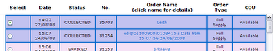
You can download Change-only Updates only for data orders you have already submitted within Digimap’s Mastermap Download facility. Go to the Your Account page within Mastermap Download and scroll down to the table of Orders.
You will see a list of all your previous Orders, and in the final column you will see whether or not CoU is available for that Order.
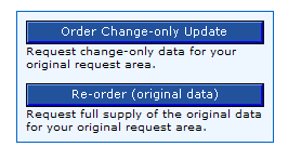
If CoU is available, click the radio button in the far left column for the Order you require. Below this table, you will see two buttons in a blue box:
Click the first button to Order Change-only Update. The data file will be delivered in the usual way: you will receive one email to say your Order has been received and is being processed, and a second email to say your data is ready for collection.
If you submit a new order for OS MasterMap data, by defining the Layer, Themes and your chosen area, you will automatically receive the latest version of the data; this will include all the latest changes. Change-only Update will therefore not be available for such an Order until the next batch of CoU is released.
Example
You submit an Order for data on 20 March 2009. In the Orders table under Your Account, the Order details say that CoU is not available. This is because you already have the latest version of the data.
If you submit a second Order for data on 27 March 2009, you will also see that the order details say that CoU is not available. Again, you have the latest version of the data; it includes the changes which were released on 24 March.
If you go back to look at your first Order (submitted on 20 March) on 2 April 2009, you will see that COU is now vailable for this Order. This is because the changes released on 24 March are now available; they were not available when you submitted the original order.
* Although the latest update is dated 20 January 2009, it takes time for Ordnance Survey to process and release these data, to send them out to EDINA and for EDINA to process and load the data into the database. This accounts for the time delay between the “freeze date” of the database (20 January 2009) and the release date (24 March 2009).
Data Updates
The annual update to the contemporary Ordnance Survey data took place on Tuesday 2 September 2008. You can view the update dates of the new data in the Digimap Help pages and on the EDINA website here.
As per previous announcements on this blog and elsewhere, Land-Line.Plus is no longer available through the Digimap OS Collection. Ordnance Survey are withdrawing all licences and support for this product and therefore Digimap has ceased to deliver it also. This forms part of the transition to the OS MasterMap framework. If you require large-scale detailed data, please use the OS MasterMap Topography Layer, available through MasterMap Download.
Within Geology Digimap, the 1:50,000 scale data has been updated from version 3 to version 4. We have also made it possible to produce PDF maps from the Geology Mapper service. In order to do this, make sure you add your chosen map to the Map Chest, and then click the link to “Generate PDF” from there.
Within Marine Digimap, the Hydrospatial data available has been updated to the June 2008 version. There are no updates to the Charted Raster data.
Tell us what else you would like!
Negotiations for the new Ordnance Survey licence agreement (covering August 2009 onwards) will begin very shortly. If there are issues you would like addressed in the new licence, or additional datasets you would like to see included, we need to hear about these AS SOON AS POSSIBLE. Please email edina@ed.ac.uk with details. Proven demand from service users carries far greater weight than EDINA’s voice in effecting change to both licence agreements and in the acquisition of additional data. We need to hear from you!
On Tuesday 2 September EDINA will be making the annual data update to various datasets offered through the Digimap Collections. This means that all the Collections will be unavailable between 17.30 and 20.00 hours.
his is a further reminder that Land-Line.Plus data will no longer be available through Digimap’s Ordnance Survey Collection from 2 September 2008.
If you have existing holdings of Land-Line.Plus data, you may continue to use these until the end of the current licence period, that is, until 31 July 2009.
All Land-Line.Plus data must be deleted at the end of the current licence period. From 1 August 2009 Digimap users will no longer be licensed to use Land-Line.Plus data.
Land-Line.Plus replaced by OS MasterMap Topography Layer
Digimap will cease to deliver Land-Line.Plus data at the end of August 2008.
As a registered Digimap user you may continue to hold and use any Land-Line.Plus data you already have until 31 July 2009. Beyond this date, you will be required to delete any Land-Line.Plus data you hold, and will not be licensed to use it thereafter.
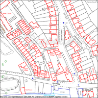
Land-Line map of urban area
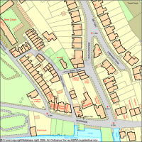
Land-Line.Plus has been replaced by OS MasterMap Topography Layer. These data are available from Digimap’s MasterMap Download facility, within the Ordnance Survey Collection. The OS MasterMap Topography Layer is as detailed as Land-Line.Plus but contains a much richer attribute set. It is also available in GML format, rather than NTF.
Corresponding OS MasterMap Topography Layer map of urban area
More information about OS MasterMap can be found within the Digimap Help pages.
After 1 August 2008 you will need to use OS MasterMap Topography layer instead of Land-Line data. Land-Line is the most detailed data available through the Data Download facility within Digimap’s OS Collection. It has been replaced by OS MasterMap Topography layer, which is equally detailed and available through the MasterMap Download facility.
Two OS MasterMap Layers, Topography and Integrated Transport Network, have been available from Digimap’s OS Collection since September 2007. These layers are available through the MasterMap Download facility. You can read more about OS MasterMap data on our OS MasterMap website and within the Digimap Help pages. Look in the sections under MasterMap Download and Data Information.
There are several software packages available which make the process of loading and viewing the OS MasterMap in GIS applications quite simple, more simple than using Land-Line data, in fact. These are in addition to ‘built-in’ converters supplied with the most recent versions of ArcGIS (Productivity Suite), MapInfo and AutoCAD software.
Viewing data
If you wish to simply view the OS MasterMap data (rather than undertake any spatial analysis, querying or manipulation), there is a simple viewer produced by Snowflake Software. It is called the OS MasterMap Viewer and can be downloaded for free (upon registration) from the Snowflake website.
MapInfo
The following applications are free and will load OS MasterMap, fully represented, into MapInfo:
InterpOSe (Digimap Edition) from Dotted Eyes. This is available free of charge on registration with Dotted Eyes. It includes full OS MasterMap styling, and will convert data to various file formats, including Shape, TAB, mid/mif and DWG/DXF.
ArcGIS
The following applications are freely available:
Productivity Suite 1.1. This is freely available to those licensed to use ArcGIS through Eduserv Chest. It contains MapManager and will convert OS MasterMap to Geodatabase format and comes complete with a number of layer files for representation (details can be found in the local installation folder of Productivity Suite). You will need a special Athens username and password to access the software download area. This should be available from your local Chest Representative or ESRI Technical Contact.
InterpOSe (Digimap Edition) from Dotted Eyes. This is available free of charge on registration with Dotted Eyes. It includes full OS MasterMap styling, and will convert data to various file formats, including Shape, TAB, mid/mif and DWG/DXF.
AutoCAD
InterpOSe (Digimap Edition) from Dotted Eyes. This will convert OS MasterMap to DXF and DWG and has a template file (.DWT) for representing the data using OS style. InterpOSe can be downloaded for free from Dotted Eyes website on registration there.
There are other packages and resources available which are detailed on our OS MasterMap website. Ordnance Survey also provide information about software which will read OS MasterMap data.
Instructions on using MapManager 9.1 and InterpOSe are included in the Digimap Help pages. Look in the section labelled “Using Data with GIS”. If you have any questions about the information provided here, please contact the EDINA Helpdesk on edina@ed.ac.uk or 0131 650 3302.

