Any views expressed within media held on this service are those of the contributors, should not be taken as approved or endorsed by the University, and do not necessarily reflect the views of the University in respect of any particular issue.
Digimap is an online map and data delivery service, available by subscription to UK Higher and Further Education establishments. Operated by EDINA at the University of Edinburgh, Digimap offers a number of data collections, including Ordnance Survey, historical, geological, aerial photography, LiDAR, marine maps, land cover mapping, global mapping and census data. For more information about Digimap go to our website: https://digimap.edina.ac.uk Background image Contains OS data (c) Crown Copyright and database right 2022
Any user of Marine Digimap might be interested in this workshop, being held in London by our marine data partner, OceanWise Ltd. We are pleased to be able to share this opportunity with you. If you’re interested in attending, please contact OceanWise directly (contact details below).
OceanWise are running their popular Marine Data Management and GIS Workshop on 27th November 2018
This free event is back and is bigger and better than ever covering ‘What is data and why should we care’? ‘Why should data be seen as infrastructure?’ ‘Smart Ports – a myth or reality?’.
Join industry experts, share your experiences and learn how GIS technologies can successfully deliver savings in time, effort and money. Take part in the debate on open data and network with contacts from a range of industries and sectors.
OceanWise Ltd is an independent company specialising in all aspects of marine environmental data acquisition, data and knowledge management and GIS providing customers with comprehensive and cost effective end-to-end marine and coastal data management and decision support including:
We are very pleased to announce that we we recently added WMS (Web Map Service) functionality to all Digimap Roam applications. This new facility allows you to pull in map data from a whole host of publicly accessible services allowing you to visualise a wealth of data in the familiar Digimap Roam interface. This is beta functionality, and there are a few areas that need further improvement but we were keen to get it out there as quickly as possible so that you could start making use of it. Whilst we continue to work on the functionality, we welcome any feedback you may have. Our contact details can be found at the bottom of this post.
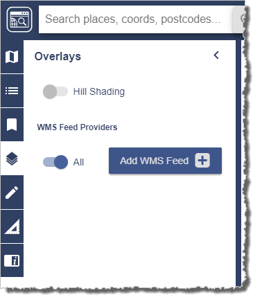
The WMS functionality can be found in the Overlays menu panel on the left hand side:
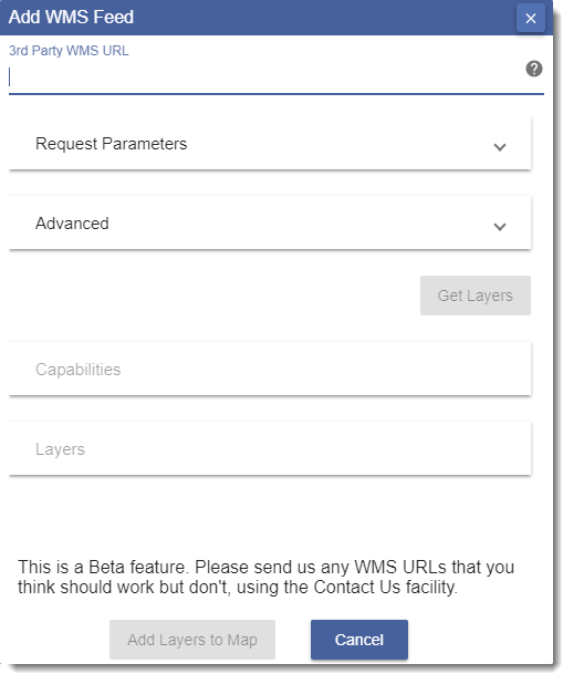
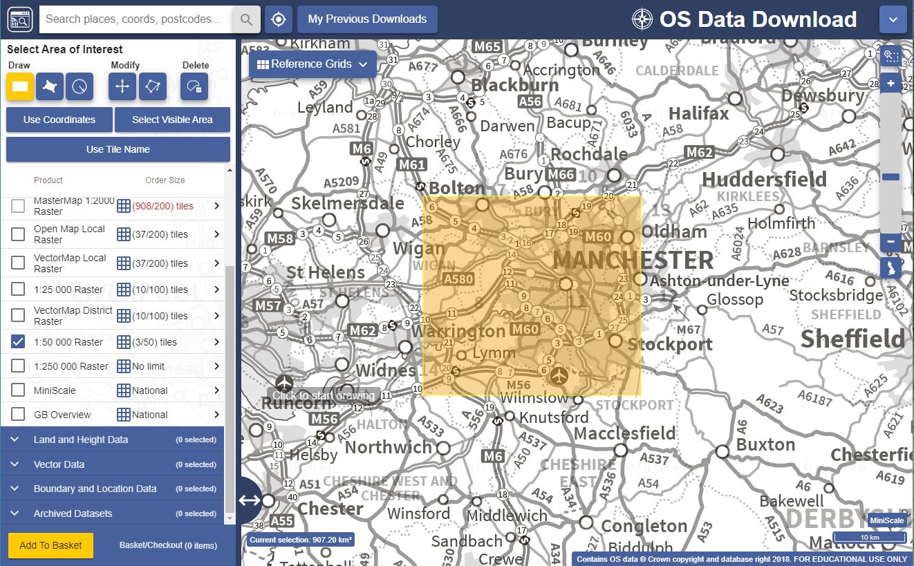
To add a WMS feed to your map you need to press the Add WMS Feed button, which will bring up the following window:
You will need to paste the getCapabilities URL in to the ‘3rd Party WMS URL’ field at the top of the popup. This URL is usually in the following format, but may be different depending on the service:
Having entered the URL the Get Layers button should become active, press this to retrieve all the layers available via the entered WMS URL. Finally add the layers to your map using the Add Layers to Map button to add them to your current map window. You can then control the opacity of each layer using the appropriate opacity slider and the order they are displayed by clicking and dragging. It’s possible to edit the names displayed e.g. to choose shorter names that are easier to see by pressing the edit button next to each entry:
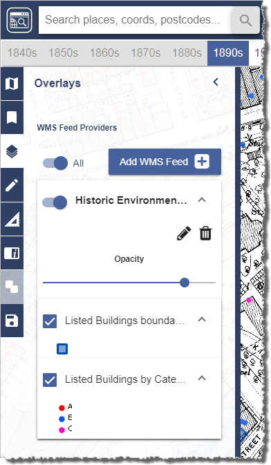
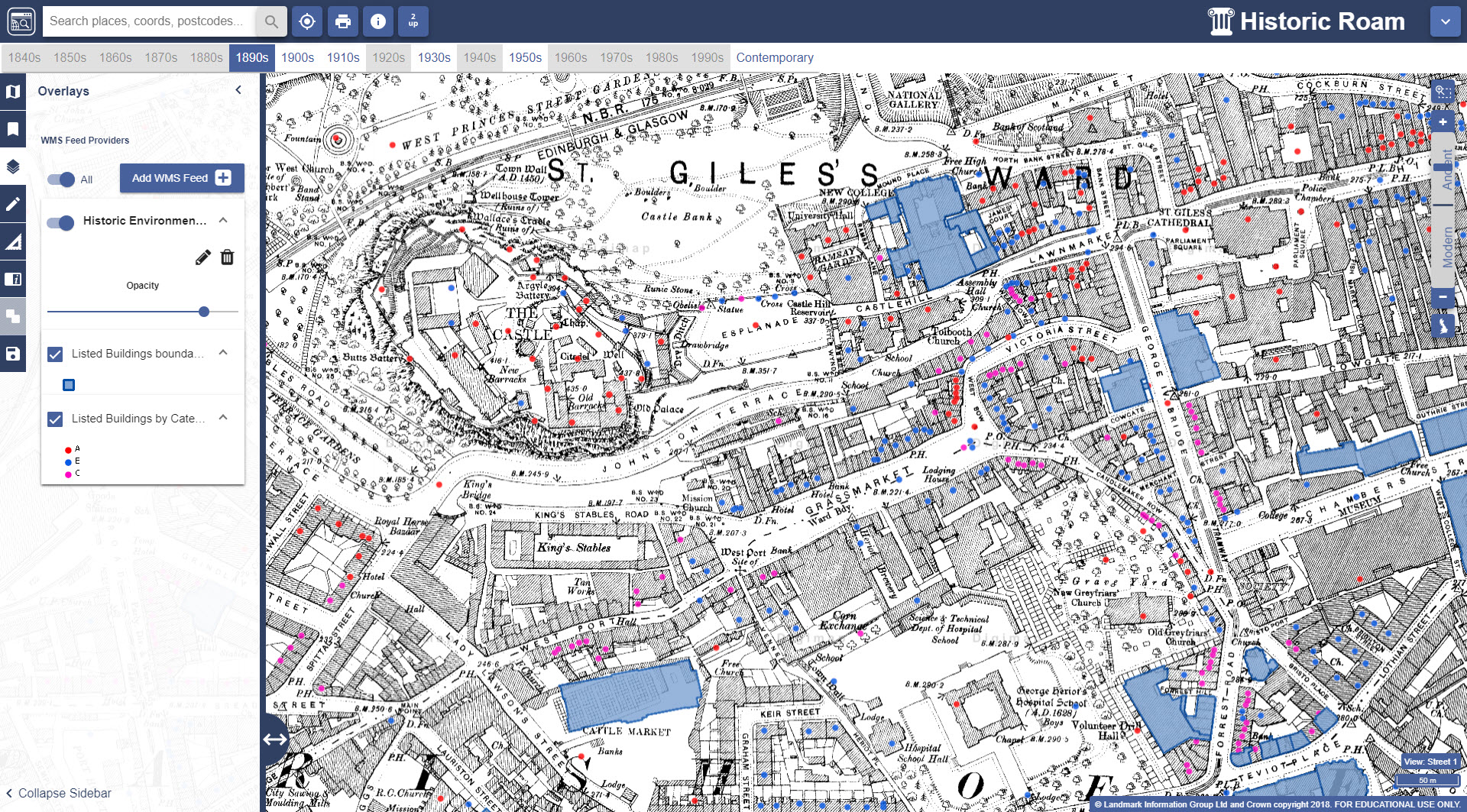
There are numerous WMS available for the UK, many of which are listed on data.gov.uk. The image below shows listed buildings (boundaries and category) published by Historic Environment Scotland on top of the 1st Edition 1:2500 County Series map published in 1896 in Ancient Roam:
Listed buildings pulled via WMS on top of historic map from 1896 in Historic Roam
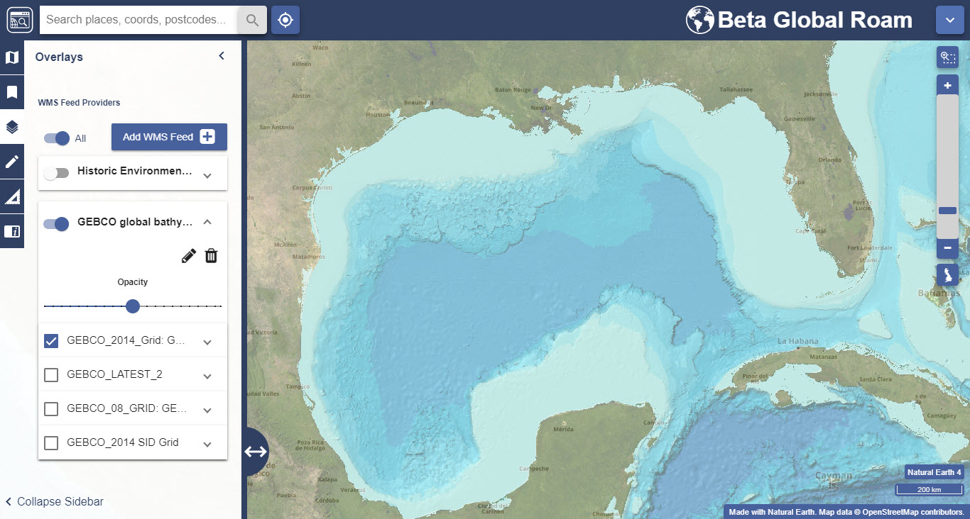
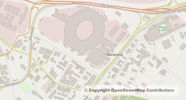
There are also lots of WMS available that serve up global data and can be viewed using the latest Global Digimap collection. One example of this is the General Bathymetric Chart of the Oceans (GEBCO), shown below in Global Roam centred on the Gulf of Mexico:
Bathymetric data via WMS on top of OpenStreetMap data in Global Roam
We have put together a help page which lists examples of a variety of WMS from different sources. Whilst we can’t guarantee that they will all work all of the time if you do come across a WMS that you think should work and have tested that it works in other software, such as QGIS or ArcGIS Online, please let us know so we can improve the service.
Known issues
As mentioned above, this is new betafunctionality and as such there are a number of known issues and things to bear in mind:
Currently no warning messages are displayed if a WMS fails to load. If the data has not appeared after a reasonable period of time please try to access the data via the same URL in QGIS or ArcGIS Online. If the data does load in QGIS or ArcGIS Online please send the URL to us so we can investigate.
In some cases the Get Layers button will not return any layers. When this happens it is worth copying and pasting the text displayed if you visit the getCapabilities URL in a browser window in to the Advanced box.
WMS data is not included in print files.
It is not currently possible to edit the details of a WMS service or dataset names in IE11 as the wrapping in the edit window is not quite correct.
Some WMS URLs (including those published by the Environment Agency) are published with the HTTP prefix but in order for these to work in Digimap Roam you need to change the prefix to HTTPS instead.
The WMS must be able to supply data in the same projection of the current Roam application. All Roam applications use the British National Grid with the exception of Chart Roam and Global Roam which both use WGS84 Web Mercator. No warning is given if the WMS projection is not compatible with the current Roam application.
WMS entries in the Overlays panel are persistent between log-ins in the same browser, so if you add a WMS in Chrome, the same WMS entries will be available the following day in Chrome providing the browser cache/temporary storage has not been cleared overnight.
WMS entries added in one Roam application are also automatically available in all other Roam applications e.g. if you add a WMS in OS Roam it will also be available in Historic Roam etc.
There is no Get Feature information displayed for a WMS layer so you cannot click on a feature and get its attribute information. However the Legend for the layer is displayed in the WMS panel if you expand the layer.
Get in touch
If you have any questions or comments about the new functionality please do not hesitate to get in touch; our contact details are below:
We are very pleased to announce the release of Global Roam. This builds on the release of Global Download last week and allows users to browse global data in the familiar, user friendly, Roam online mapping interface. Global Roam is very much a work in progress and you will find that some of the standard functions are not yet available, but we were keen to get something out to users as soon as possible and we’d love to know what you think of it and where you think it can be improved.
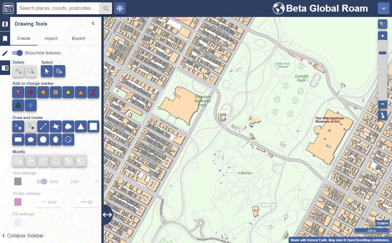
Global Roam showing Central Park in Manhattan
As mentioned in our previous blog post, Global Digimap is available as a beta service as we look to build a suite of datasets, themes and formats that best meets the needs of our users. We will continue to develop the Global Digimap service over the coming months, shaped by the feedback that you give.
Global Roam delivers the familiar Roam interface with detailed global data sourced from Natural Earth and OpenStreetMap. The application includes the usual annotation tools (recently renamed ‘drawing tools’) along with global search functionality. The most zoomed out maps use Natural Earth data which changes to OpenStreetMap as you zoom in. Future plans include:
adding additional data from the rich OpenStreetMap dataset including point features
integrating the print interface to allow high quality printed maps up to A0
addition of the feature information tool allowing users to view the attributes of selected features
creating alternative grey-scale and colour basemap styles
inclusion of the measurement tools [update: these were added 30/08/2018]
customisation of the map through the Map Content panel
It’s worth mentioning that maps saved in Global Roam are not compatible with other Roam clients and vice versa as they use a different projection system. [update: this was resolved 30/08/2018]
Access to Global Digimap
During this development phase, and in return for engagement with the development process, the service will be free of charge for institutions that subscribe to another Digimap Collection. We would like to know what you like and don’t like about it, what features and what new data you would like to see added. We can’t promise to include everything but the more we hear from you the better able we are to prioritise different requirements and create the best possible service.
If you would like access to Global Digimap please ask your local Digimap Site Representative to request access through the Digimap helpdesk and we will ensure your institution is switched on.
Get in touch
It is never too early to let us know what else you would like to see, we are very keen to hear your ideas of how we can make something really useful; our contact details are below:
You can open your blog up to as many or as few people as you like in Dashboard > Settings > Reading > Site Visibility:
You can open your blog up to specific University members by adding them as users to your blog.
You can open your blog up to all University members who have an EASE login.
You can make you blog open to the world.
The featured image on this post comes from the University Collections. If you want to use more images in your blog posts, or perhaps use your own choice of image in your blog header, you can:
It is the start of a new academic year and we have introduced few new things for you to see in Digimap:
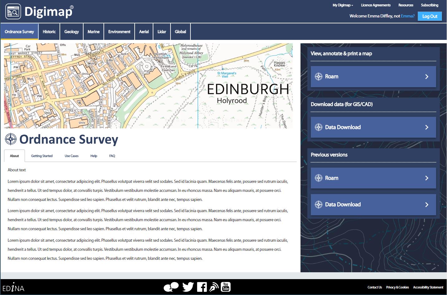
A New Home Page
Digimap has a new home page! It may look a little different, but it works in exactly the same way as the previous version. Responding to feedback from the community we have provided more detail about each collection in the left hand panel, including preview images of the data. Roam and Data Download are easy to find under each Collection’s tab.
Global Digimap
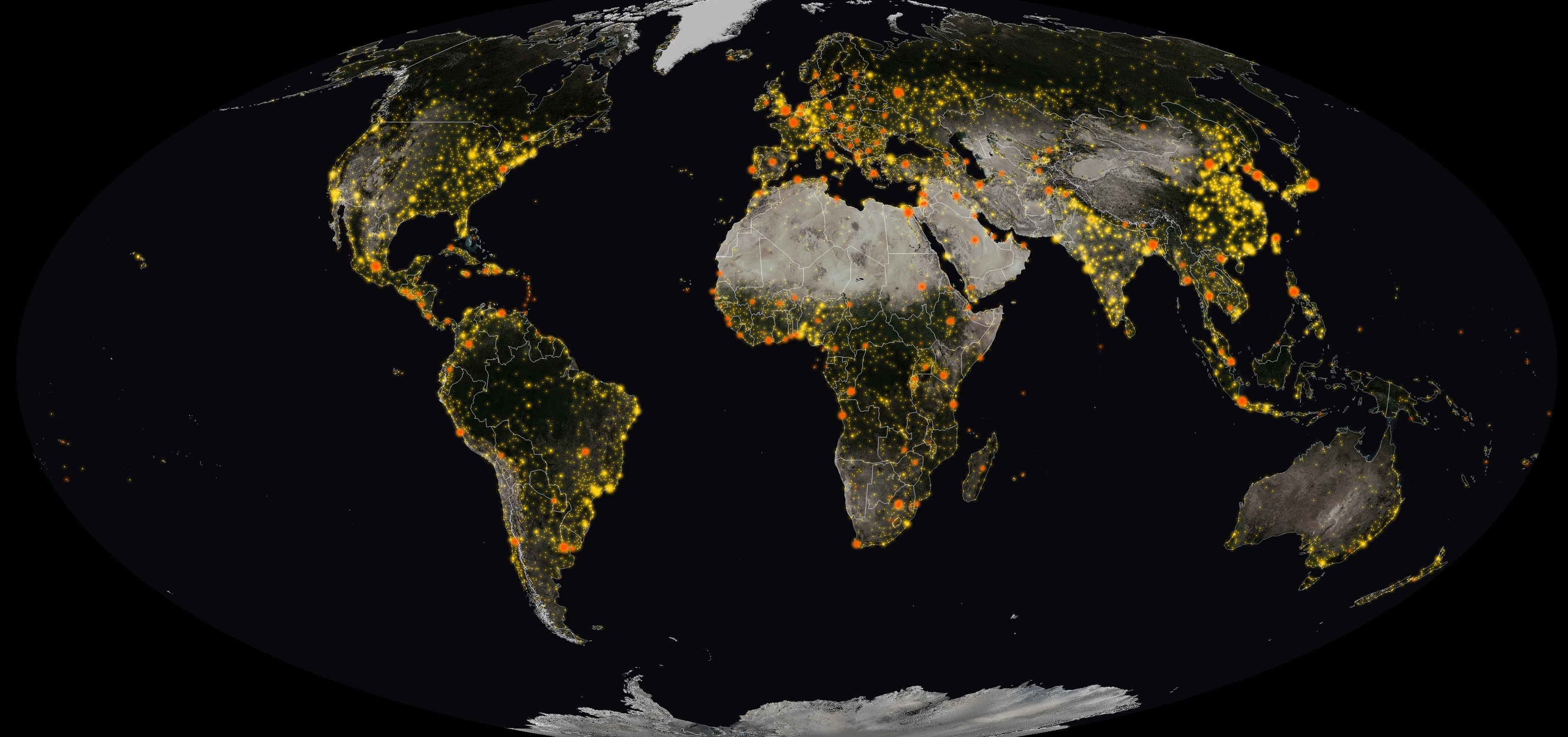
We are very proud to announce the launch of our new Global Digimap collection. This is a new service, developed in response to requests for international data. Initially Global Digimap will offer OpenStreetMap data but our objective is to develop the collection in partnership with the user community, so user feedback will shape both the content and functionality. In return for this engagement, access to Global Digimap will be free of charge until July 2019.
We have asked all the Digimap Site Reps if they would like access to the service, if you can’t access Global Download then speak to your site rep about getting your institution switched on: List of Digimap Site Reps
Following a lengthy beta phase, we have promoted the beta version of Data Download to a production service and this is now the default Data Download application for all Collections. Ever mindful that work flows, and teaching and promotion materials may need updating as a result, we will continue to run the previous versions of both Roam and Data Download until the end of the year. All saved maps and data download histories are available in both new and old versions.
New Licences
Digimap is now operating under new licences for 2018/19 so all registered users are required to accept the new terms. This is a simple process which happens when you first log in. No re-registration is required and all saved maps and data download histories remain available as before.
On 1st August 2018 EDINA launched a new Digimap Collection, one that aims to provide data for the whole world, not just Great Britain.
Global Digimap is now available as a beta service as we look to build a suite of datasets, themes and formats that best meets the needs of our users. We will continue to develop the Global Digimap service over the coming months, shaped by the feedback that you give.
During this development phase, and in return for engagement with the development process, the service will be free of charge for institutions that subscribe to another Digimap Collection. We would like to know what you like and don’t like about it, what features and what new data you would like to see added. We can’t promise to include everything but the more we hear from you the better able we are to prioritise different requirements and create the best possible service.
“We are developing this service in partnership with the community; it will be subject to continuous improvements. Please keep checking back to see how it develops; please keep the feedback coming; please be understanding if the service is different today from yesterday!”
Below are details about the data and service available now, and what we plan to include in the short term. It is never too early to let us know what else you would like to see, we are very keen to hear from you; our contact details are at the bottom of this post.
Overview
The service is currently built around two key datasets, OpenStreetMap and Natural Earth, but we will be looking to add more on your recommendation. We will also be using the two familiar Digimap interfaces, Roam and Data Download to provide access to the data.
OpenStreetMap
This is a global dataset created by contributors either volunteering their time or working on projects that are adding information to the dataset. Feature types and attribute information is carried mostly in a single data column as tags in the data’s raw format. We have created our own instance of the data which we update on a daily basis. From our own database we will be creating a set of more usable data tables each weekend, to provide users with data to download in more usable themes.
There is an amazing amount of information in OpenStreetMap but it is quite inconsistent; there are areas where the quantity and quality of mapping is incredible, most of Germany is covered in great detail and Edinburgh too. There are of course other areas where not much detail has been captured at all, however the great thing about OpenStreetMap is that you can contribute and capture the data yourself. The data should never be considered to be definitive but in many cases it is the best data, sometimes the only data, available for a location.
We have categorised OpenStreetMap data so that we can deliver it in a set of themes for download: Buildings, Landuse, Natural Places, Place of Worship, Points of Interest, Railways, Roads, Traffic, Transport, Water, Waterways. We are also hoping to add Addresses and Administrative Boundaries as layers soon too.
We will provide the data in Geopackage and File Geodatabase formats for ease of use in QGIS and ArcGIS but hope to add DWG format data too. The DWG format will mean that building outlines from around the globe will be available for CAD users.
We are also creating cartographies for the data so that you can view, annotate and print it using the Global Roam interface.
Natural Earth
Natural Earth data is a curated set of small scale, (1:10m, 1:50m and 1:110m) mapping datasets that are great for using in overview maps or to show global analysis. This is an Open dataset so can be used for any purpose, not just academic. We will be using the Natural Earth data in Global Roam and Global Download as the interface maps at the most zoomed out levels.
As we have the data we will be providing through the download interface which will be a more convenient way to get multiple layers of data than the Natural Earth website. When we introduce clipping of vector data downloads in the future this will add a very useful dimension. This will enable you to select your own areas of data rather than having to take global coverage.
What can I see now?
Global Download
The download interface will allow you to take OpenStreetMap data in Geopackage and File Geodatabase formats. There is the ability to select themes limiting the number of features you get in your data. Not all the OpenStreetMap data falls into one of the themes but we are working to incorporate as much as possible. As such the themes are subject to change.
Going forward we will be adding the Natural Earth Data and others requested by users where possible. We will also be looking for feedback on new themes to add to the OpenStreetMap data and extra feature types to add to existing themes.
Global Roam (Coming Soon!)
The familiar Roam interface with the usual annotation tools and a global search will be added to the collection very shortly. The most zoomed out maps will use Natural Earth Data which will change to OpenStreetMap as you zoom in. We will be creating grey-scale and colour themes, but we want to grow this range quickly. Our print interface will be integrated, allowing high quality printed maps up to A0 too though this will come later. We also plan to allow customisation of the maps using the groups and themes we develop, later in the year.
What we’d like you to tell us:
Global Digimap is going to be a collaborative project between the academic community and EDINA. We want to produce a service that will meet the needs of the majority of the community, making global datasets accessible to as broad an audience as possible for teaching and research. This is ambitious and we accept that we won’t be able to meet everyone’s needs all the time, however if you never let us know what they are we won’t have a chance to try.
Are there any other datasets you like to see us include in this collection?
If you know of global datasets that you’d like to see in the collection please let us know. We aren’t always able to include datasets but we will try to include any that are possible. Please note that many Open datasets have non-redistribution clauses that prevent us from simply delivering them through Digimap. However it is always worth bringing them to our attention as we may be able to secure an exemption.
Are there any additional Themes you want us to make available for download?
OpenStreetMap data is huge and very complex, so if there is any way we can make it more accessible then let us know. We are aware that many features have been captured in different ways in different countries, regions or sometimes simply by different people. We are also aware that it is difficult to get large areas of the data with all the features you need or in the format you want If there is a particular subset of features that you need then let us know. If there is wider demand for this then we will aim to create them for the service.
What basemap styles would you like to see in Roam?
We would like to see the OpenStreetMap data utilised to its full potential and so we would like to create different basemaps to highlight different feature types. If you’d like a basemap that highlights natural features like forests, marshes and protected areas; one for road networks; residential, commercial and industrial zones; or perhaps a heritage and antiquities basemap then we’d like to hear from you. If you have already done some work with OpenStreetMap to create a particular style for your field of study then we’d be very interested if you would like to share your work to make the style more widely available through Digimap.
What formats suit the research you want to carry out?
For OpenStreetMap we are aiming to cover GIS and CAD with the Geopackage, File Geodatabase and DWG formats. However if there are other formats you’d really like to see then please let us know. We appreciate that many users may like to see Shapefile formatted data and if demand is strong enough we may provide some limited feature sets in this format. Do note that the file size and geometry type limitations of Shapefiles don’t make them ideal for OpenStreetMap data.
Natural Earth vector data comes supplied as Shapefile so we will pass this format on to users, we will look to convert the data in to other appropriate vector formats like Geopackage and File Geodatabase. We will also be looking to clip these datasets to the area defined by the user in the interface, to keep download sizes small and to make the data fit the users requirements more closely.
Natural Earth Raster Data comes supplied as GeoTiffs and again we will make these available for download. If there are any other raster formats that you need then please get in touch. Again we will be looking to clip these datasets to the user defined area in the interface.
Get in touch
This is what we have planned but there is scope for so much more, so please get in touch with your ideas so we can start to build something amazing:
Digimap is launching a fresh, new-look home page on 1st August 2018. All the functionality of the current page will still be available and easy to find, but the new page will look like this:
Links to each Digimap Collection run horizontally across the top of the page, rather than vertically down the left hand side, leaving room for future developments.
As with the current homepage, login is possible either using the login button in the top right corner or by accessing each Roam or Data Download application directly.
There is also now a bold image illustrating the maps and data in each collection, making it clear what to expect when you access the service.
“Access maps and data in just two clicks: select the collection first, then the application you need.”
The left hand column has expanded to include more information about the maps and data in each collection. It also provides more detail on how to access the maps and data and easier links to help information. Our objective was to provide a better insight into the content of each Collection, inspiring ideas and showcasing some of the data available.
Access to Roam and Data Download will continue to be easy using the big buttons on the right hand side. You will also be able to access previous versions of applications, as you can now, below the current versions, and the existing user registration system remains unchanged. We have endeavoured to make better use of the space on each page, offering a fresh new look while maintaining a clear and easy route to access all facilities.
The data available through Marine Digimap is changing on 1 August 2018.
(c) British Crown and OceanWise, 2018. All rights reserved. Licence number EK001-20180802. Not to be used for navigation.
From 1st August 2018, Marine Digimap will offer data from OceanWise Ltd., specialists in marine environmental data. The new data offers almost identical content and will be available for both mapping and data download. Regular data updates will also be supplied.
The data currently available (until 31 July 2018) is licensed by SeaZone, whose data products have been discontinued for both new sales and renewals. This means that the SeaZone data cannot be provided beyond the end of current licences.
Watch this space for more information about the data change. As ever, we are happy to answer any questions you may have. Our contact details are below.
We are delighted to announce that a new version of Digimap’s Data Download is now available. This is a “beta” version so we will keep the current interface running while you explore the new improved service. We know that teaching and support materials may need to be updated so we hope that a transition period will help.
Data Download takes it’s new fresh-faced look from the recent updates to Roam, Digimap’s mapping facility. The search bar is now at the top left hand side and all the action happens in the variable width side panel below it. A big improvement is that you now have more ways to specify the area of data you need. In addition to defining a rectangle, you can now create an irregular polygon as your area of interest or a buffer zone from a point or line that you define. We’ve also added a “Locate Me” button* to help you easily find data for the area local to you.
The panel on the left now shows a straightforward and easy-to-use list of all available data and shows more clearly how much data can be selected in a single request, along with the availability grids for each product.
As ever, you can add multiple products to any data order, selecting the format, version and date from the basket prior to submitting your order. As a new feature, you can now request your data to be sent to you as a single download, or for each dataset to be sent as soon as it’s ready.
Remember Digimap has a lot of previous versions of several datasets, dating back to 1999 in some cases. If you are interested in data for a specific date, use the Version drop down menu in the basket to access the archives.
We welcome any feedback you may have on the new interface; please get in touch:
In line with the new General Data Protection Regulations (GDPR) which come into effect on Friday 25th May 2018, we have updated our Privacy Policy for Digimap. You can find a copy of it here:
This document describes what personal information we collect and how we use that information.
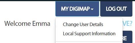
If you would like us to contact you with information about new products and services EDINA may offer you can check your communication preferences by logging in to Digimap, going to My Digimap in the top right hand corner and selecting Change User Details.
We will still send you important service related messages, such as the addition of new data products, maintenance periods and the introduction of new functions and features. If you choose to unsubscribe from one of our emails, though, you may not get these messages