Any views expressed within media held on this service are those of the contributors, should not be taken as approved or endorsed by the University, and do not necessarily reflect the views of the University in respect of any particular issue.
Digimap is an online map and data delivery service, available by subscription to UK Higher and Further Education establishments. Operated by EDINA at the University of Edinburgh, Digimap offers a number of data collections, including Ordnance Survey, historical, geological, aerial photography, LiDAR, marine maps, land cover mapping, global mapping and census data. For more information about Digimap go to our website: https://digimap.edina.ac.uk Background image Contains OS data (c) Crown Copyright and database right 2022
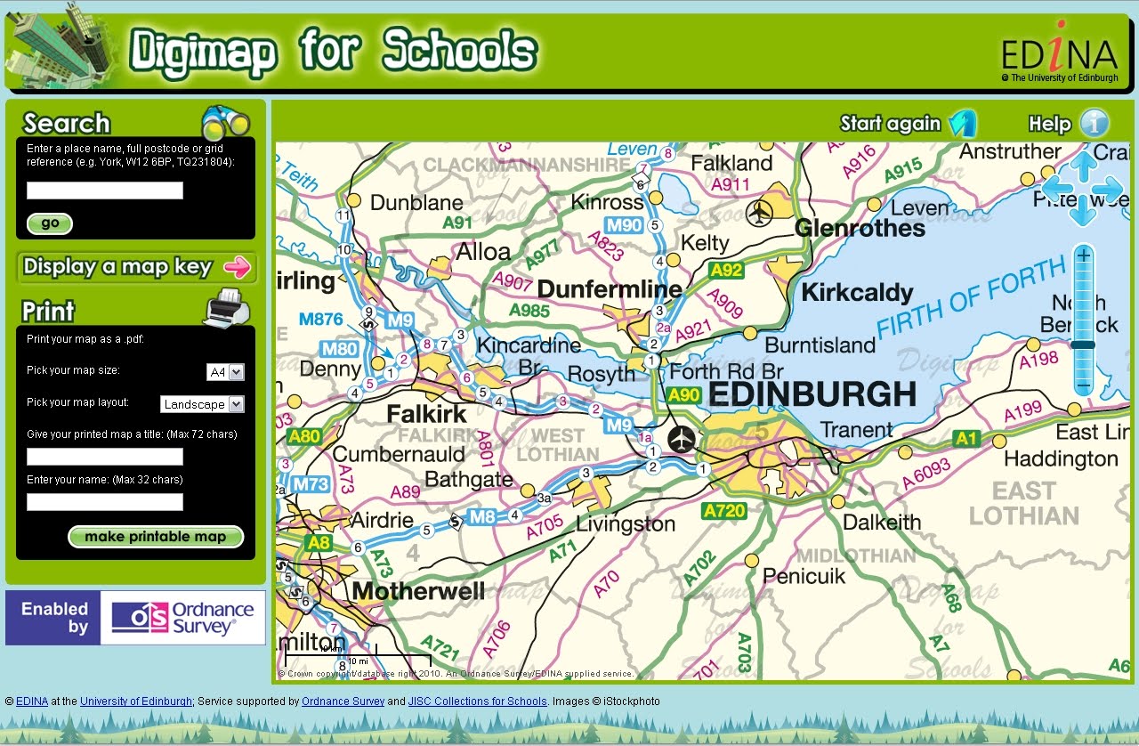
Baroness Joan Hanham CBE, Parliamentary Under Secretary of State for Communities and Local Government (CLG) has launched a brand new service to help improve the teaching of geography in schools with Dr Vanessa Lawrence CB, Director General and Chief Executive of national mapping agency Ordnance Survey. The launch took place at Graveney School in Wandsworth, London on Wednesday 10 November at 2pm.
Ordnance Survey is increasing its support for the teaching of geography at all levels by launching a brand new online mapping service for all schools across Great Britain. ‘Digimap for Schools’ provides schools with easy access to Ordnance Survey’s most detailed digital mapping for the whole of Great Britain. For the first time, pupils will have access to maps showing individual building outlines as well as familiar scales of mapping used by outdoor enthusiasts and on websites.
Here at EDINA we are constantly evaluating our services and really value user feedback. Our funders are also keen to know what impact the services have. We are currently assessing how satisfied our users are with the Digimap Collections so we can gauge how well we are doing. Please could you fill in a quick user satisfaction survey for each of the Digimap Collections you use; you can pass on the links to anyone else you know who uses Digimap.
The survey is very short with only 5 questions after you have put in some details about yourself. All data collected will be held anonymously and securely. No cookies are used in the completion of the survey.
EDINA would like to take this opportunity to remind Digimap users that another of it’s JISC-funded services Go-Geo! (www.gogeo.ac.uk) can save time and effort when looking for geodata. Searches for data can be carried out against a number of catalogues held across government holdings, research data centres and data repositories. Increasingly Go-Geo! offers direct access to the data but if not, it offers the name and contact details of whom to contact to obtain the data. Go-Geo! also offers resource channels which can be browsed for up-to-date news and information on free software, online services, data providers, events and books. For those creating data as part of their studies there’s a wealth of information describing how best to document and describe geospatial data including access to geodoc, a tool for creating standards-compliant metadata. For all your geospatial data needs visit www.gogeo.ac.uk today.
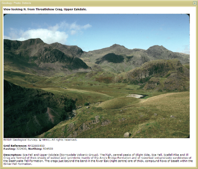
Geology Roam now allows you to view British Geological Survey images (of geological features, rocks, fossils and the BGS at work) from the JIDI Image Collection. The images area accessed via the map interface when you are zoomed in to the most detailed geology maps.
There are over 3000 images mainly found in geologically rich areas such as Cumbria, North and South Wales, the Dorset coast, Edinburgh etc. The images cover a wide range of features from details of bedding planes and large crystals in rock faces to aerial photographs of valleys showing glacial erosion features.
To access the photos go to one of the 5 most detailed zoom levels in Geology Roam and click on the camera icon in the tool bar or Geological Photos tab. You can then pan around the maps till you find an area with some photos.
The photos are marked on the map at the location they were taken from; click on the markers to see thumbnails of the image(s) for the location. You can view a full sized image with detail about what is shown by clicking on the thumbnail.
These photos are useful for geologists but there are also some spectacular landscape images that can be enjoyed by everyone.
EDINA is pleased to announce the release of Digimap OpenStream – a web service delivering OS OpenData to the UK academic sector using open standard WMS technology.
Digimap OpenStream is an EDINA Digimap value-added service freely available to the academic community. Access is not restricted to registered Digimap users, although a one-off online registration is required. The OS OpenData offered is accessible 24/7 and users are able to embed it into their own application software without the overheads of downloading and managing large quantities of data.
Digimap OpenStream provides access to the following OS OpenData products:
MiniScale®
1:250,000 Scale Colour Raster
OS Vector Map™ District (Raster)
OS Street View®
Details of the Application Programming Interface (API) are provided along with simple guides illustrating how to use the service within popular GIS software.
Some new Digimap training event dates have been advertised on the EDINA website. Both courses (which require attendance in person) and webinars (requiring online attendance) have been scheduled. Further details of both can be found on the EDINA Events and Training page:
To find an event by it’s location, try our Events Map: http://edina.ac.uk/events/eventsmap/
This will show you the location of all the events EDINA is taking part in so that you can find an event near you easily. Different types of events are colour-coded and you can zoom in and out of the map to clarify locations.
Signing up for an event is easy. You can register online using the booking form provided with the details for each event.
The Chest Agreement with ESRI expires on 31 July 2011. Some of you may remember helping to shape the current Chest Agreement and how tricky it was. We’re starting work on the renewal early, with a break-out and discussion session at the Eduserv & ESRI Event for Higher Education on Thursday 23 September 2010 at the Congress Centre in central London.
This event follows on from the success of two previous technical events, held at the University of Leeds in 2008 and University of Birmingham in 2009. The meeting is intended to bring together people from universities who are either using ArcGIS or other ESRI software or providing and supporting ESRI software in their institutions.
In addition to the very important session on shaping the new Chest Agreement, this year’s event will also feature sessions on:
* What’s new in ArcGIS 10
* How to get the most from Virtual Campus
* Mobile GIS best practice
* User presentation from University of Worcester.
Most of the presentations will be by people from within the Higher Education community. The event will also include a free (optional) networking breakfast for both users of GIS and those who licence the software to share experiences and discuss challenges. Lunch is also included.
Head of Research and Geo Data Services £46,510 – £52,347
Open-ended Contract
We seek a recognised leader in Geographic Information to sustain, develop and advance our strategic contribution to research and education in the UK. Use your experience in the use of geo-data, and proven record of research and team-working, to deliver online services and take forward project work at EDINA.
Based in Information Services at The University of Edinburgh, EDINA has world-class reputation for its service delivery and project success, in geographic information and more widely, http://edina.ed.ac.uk/. As a UK National Academic Data Centre, designated by the JISC, EDINA serves the needs of staff and students in universities and colleges across the UK, and is called upon to meet needs in the policy research and the school sectors – examples include support for INSPIRE and the recently-launched Digimap for Schools.
For further details about the post and to apply, please visit www.jobs.ed.ac.uk Job Ref Number: 3013235
On 31st August, the annual update available through Digimap’s Ordnance Survey Collection will take place. A number of data and service changes will take place.
The annual data update applies to the following datasets:
– MasterMap Topography and ITN Layers
– Meridian2
– 1:50 000 Colour Raster
– 1:25 000 Colour Raster
– 1:10 000 Raster
– Strategi
– 1:50 000 Scale Gazetteer
– Code-Point with Polygons
– Boundary Line
NB: Ordnance Survey do not provide regular annual updates to Land-Form PROFILE and do not update Land-Form PANORAMA)
Updated data will be available in all the Digimap OS Collection mapping and download services.
New dataset
During the annual data update, a new dataset will be added to Digimap’s Ordnance Survey Collection. OS VectorMap Local is a 5 x 5km tiled vector dataset, offering detailed national mapping. The data is derived from OS Landplan and is supplied in GML format. It is commonly used as a rich backdrop map to add context to user datasets. Features include roads, railways, vegetation, boundaries and buildings. Pre-defined stylesheets are available to apply to the data, or you can select and style different features in different ways to provide geographic context to your information. OS VectorMap Local will be available to download from the Data Download facility within Digimap’s OS Collection.
As OS VectorMap Local is provided in GML, it needs to be converted to proprietary data formats in order to be fully utilised. Rolta UK (www.rolta-europe.com/osvector.html) have developed a free-to-use data translator tool to convert OS VectorMap Local to ESRI Shapefile and MapInfo TAB formats. Rolta also supply styling which can be applied to Shapefiles using the Layerfiles provided with the software. Styling can be applied to TAB files during the translation process. Further information about OS VectorMap Local, translation and use can be found in the Digimap Help Pages.
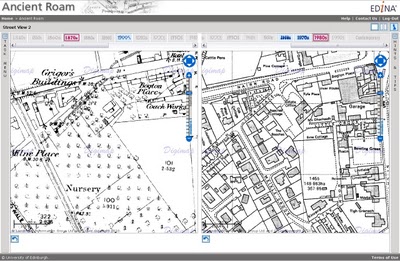
Ancient Roam
The 31st August update will see Ancient Roam move from its Beta phase to become a full service. Ancient Roam has proved very popular since its release in April generating in excess of 300,000 screen maps in four months. On 31st August, the ability to view two maps side by side to compare changes over time will be added. The 2up View provides a quick and easy way to view two maps from different decades at the same time.
A new drag to zoom tool will also be added to make it even quicker and easier to zoom quickly into your area of interest.
There are more features planned for Ancient Roam over the coming year, so please send us your comments and suggestions if you would like to see anything particular added. Although Ancient Roam is becoming a full service, the exiting Historic Mapper will remain until the end of 2010.
OS OpenData in Digimap
Some data products offered through Digimap have been released by Ordnance Survey under the OS OpenData scheme. Many of these were already available through Digimap and continue to be provided as before. Three of the OS OpenData products have not previously been available through Digimap. These are:
– OS Street View,
– OS VectorMap District
– OS VectorMap District Raster
All the Ordnance Survey products are available to download from the Data Download facility in Digimap’s OS Collection.
Digimap continues to offer full flexibility in identifying and downloading the data you want. Although the OS OpenData products are available from Ordnance Survey’s website directly, search and select options are limited.
If you have any questions about these changes or about Digimap in general, please do not hesitate to contact the EDINA Helpdesk on edina@ed.ac.uk
On Tuesday 3 August 2010, all Digimap Collections will be unavailable from 10.00 hrs until 16.00 hrs while the service hardware is upgraded. Notice of progress will be posted on the Digimap Collections login page.