The research extracts in the previous post have linked together the offerings made to water bodies and wetlands in the Baltics in early history once again with the area of Kunda. Expanding out the number of places of significance within this area and their value in relation to native Estonian culture.
The interference of the mining in Kunda is clear. The mining is what is seen as forming the present-day town and it’s people. The mining and docks at Kunda allow for the largest exports of goods in Estonia. But the mining is simultaneously taking away the very earth that holds the ancestors. It is a place that exists between two. The present seems to be destroying the past. I am wary of this thought, as I do believe in things moving forward, and I use the clay from this place, but I worry about what might be lost if we take too much. We rely on it, and although the earth can take thousands of years gradually working away to reset life forms and resources, on its slow crawling pace of life, our lifecycle is not one that can survive like that. So if we take everything now then there won’t be anything left for those of us who come next.
Maybe there is some link between preserving an ancestor’s place, not for the ancestors but for the next generation. In preserving the last generation you provide for the next. There is some cyclical understanding of learning in this.
Water seems to be one of the most precious and fragile resources. And so the respect and understanding of it, to the extent that it is felt as being part of your body, and it’s passage. To the extent that a body of water that is external to your body existing in the landscape is connected to your breathing, and your breathing after you die, makes sense. Why shouldn’t you give to it as you would give to a loved one, because without it you would never have existed.
Further information on the sites in Kunda:
(http://maatundmine.estinst.ee/kohad/kunda/kunda-hiiemagi/)
Hiiemägi Hill:
“1.7 kilometers long, up to 400 meters wide and up to 15 meters high
Folklore, however, remembers the giant mountain as follows:
Near the town of Kunda is an upland that extends from Kunda Manor to Kunda-Mallan. In the middle were large oaks and large rocks, they are no longer found in the weather. Tammesalu was a place for local people and he was called Hiiemäe. In the old days, local people, according to older people, had brought their victims there and treated their diseases. The weather must also be a burial place in the old days. It used to be a settlement under the steep slope of Hiiemäe.
We remember the sacrificial stone in Hiiumaa and the source from which the medicinal water was obtained, as well as the fact that people were buried in Hiiumaa:
There was a spring on the slope by Iie. Smell of sulfur, bitter taste. Water was taken to wash the face, against skin diseases.
When the people die, they are taken to Kunda Hiijemäe and burned, so that the spirit will go to heaven with fire.”
(From: University Of Tartu Faculty Of Philosophy Institute Of History And Archaeology. Kristjan Sander. Kunda Lammasmäe Stone Age Settlement. Master’s thesis Supervisor: Professor Aivar Kriiska. Tartu 2014.)
Translation:
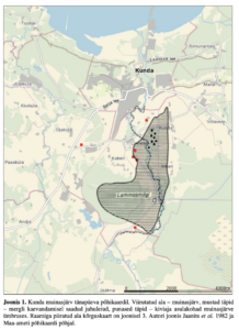
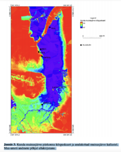
‘Kunda ancient lake on today’s main map. Streaked area – ancient lake, black spots – case finds from marl mining, red spots – Stone Age settlements in Muinasjärv around. The elevation map of the area bounded by the frame is shown in Figure 3. Author’s drawing Jaanits et al. 1982 and Based on the main map of the Land Board.’
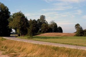
Lammasmägi Hill image from google above.

I have pieced these two fragments of maps included in the previous post together to form a full map, after looking at them further I realised they matched. A jigsaw.
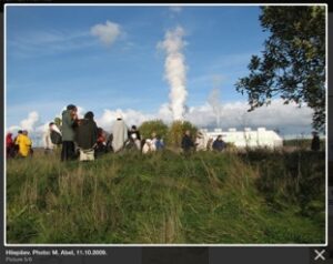
Another image of estonian Maausk gathering on top of Hiiemägi hill with the fumes of the factory in the background.
The above image and those following are all from: https://register.muinas.ee/public.php?menuID=monument&action=imagegallery&id=10290

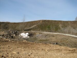
Hiiemägi Hill is the ridge. Falling into this gravel quarry.
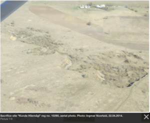
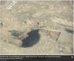
Aerial views. Dated 2014. Perhaps some of the site is still holding on and hasn’t fallen down into the old quarry site yet.
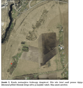
Translation:
Figure 2. The north-eastern part of Kunda Muinasjärv today. The findings of Hiie farm were obtained with a red dot marked from the field between the high slope of Hiiemäe and the quarry. Aerial photo of the Land Board.
(From: University Of Tartu Faculty Of Philosophy Institute Of History And Archaeology. Kristjan Sander. Kunda Lammasmäe Stone Age Settlement. Master’s thesis Supervisor: Professor Aivar Kriiska. Tartu 2014.)
Translation:
Figure 3. Altitude map of Kunda muinasjärv area and settlements on the shores of muinasjärv. Signatory based on the data of the Land Board.
(From: University Of Tartu Faculty Of Philosophy Institute Of History And Archaeology. Kristjan Sander. Kunda Lammasmäe Stone Age Settlement. Master’s thesis Supervisor: Professor Aivar Kriiska. Tartu 2014.)
Muinasjärv is the ancient lake. Muinas means ancient and järv, lake.
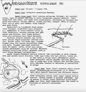
I discovered this Estonian scout handbook detailing the entire history, it’s founders, and their activities, here is a page about the muinasjärv. Roughly translated by google:
Translation:
Date of the camp: July 29 – August 7, 1961.
Laag_ri place: Kotkaj bill cub in Muskoka.
Background of the camp _mHngu: Early Estonian ancient times Ociviaeg), when it was used
stone, bone and horn raw materials and weapons. Skins were used for body covering. Elati
locally asleep, but was obtained from fishing, hunting ~ and harvested from nature
nutrients (berries, nuts, mushrooms, beets, seeds).,;
The fire was felt and they could be extinguished. As the only pet
was considered a dog.
Scientifically, the background is the ancient finds of Kunda
From Virumaa. From the poles of the settlement below Kunda- ~!
n.n. Lanrnasmael is rich in stone and
bone utensils, of an estimated age not exceeding 6000
years before Christ. These “Kunda culture”
the findings were stored in the Estonian National Museum.
According to scientists, it was based on this
above the dam created by the melting of the jaja-time lirjaja.
From this flowed the Kunda yogi, falling
below the lake from the rock wall of the Viru coast as a waterfall
alla merre. The current Lann3smagi accounted for
island vol low j bill, mi llel as us ancient inhabitants
plush chambers settlement or silent village. In the museum
there are utensils found in the resin and the lake
was later found in bottom sediment layers.
The falling masses of the waterfalls constantly break up the rocks and move
all jets over the years upstream. Kunda waterfall moved tiles to the lake, shot the lake
waters into the sea and later on the bottom of the lake.
Kunda as a dam lake created from Urgja like the ancient lake
there is currently Lilemiste Lake near Tallinn,
whose flow has been obstructed and controlled by humans
even now.
Bearing brand: Wooden (bone) arrowhead leather pendant
On the side, with cover letter M (sleeping lake) and 61 (year).
See the brand design at the bottom left of this page. —————– · ————–
The supposed map of the Kunda ancient lake has been chosen as the theme of the camp
timing. The location of VaikUla is the current Lanrnasmagi. Waterfall
is gone and the January grids are far away
f ~ half the lake. Rotten! kaliabar on the shores of the Gulf of Finland is
\ Expanded and partially forested
It is interesting to see this place as being part of the people’s knowledge and how they would communicate it. Information existing within this context rather than academic reports. I would imagine them to be reenacting living like the stone age people for one evening, camping on Lammasmägi hill and pretending that their surroundings were a vast lake. This imagination of children.
I feel that I need to go there very soon.
I had two hours of art research sharing of work with others, and two hours of presentation methods and contexts sharing of presentations last week. The conversations that arose from these have really helped and contributed to my thinking.
One thing that was mentioned was the difference in scale. The approaching of this landscape from a large expansive geographical perspective with all of the maps and searching, and then at the same time the personal attention to the specifics of the clay and small fragments of finds and people’s stories and actions.