Any views expressed within media held on this service are those of the contributors, should not be taken as approved or endorsed by the University, and do not necessarily reflect the views of the University in respect of any particular issue.
Digimap is an online map and data delivery service, available by subscription to UK Higher and Further Education establishments. Operated by EDINA at the University of Edinburgh, Digimap offers a number of data collections, including Ordnance Survey, historical, geological, aerial photography, LiDAR, marine maps, land cover mapping, global mapping and census data. For more information about Digimap go to our website: https://digimap.edina.ac.uk Background image Contains OS data (c) Crown Copyright and database right 2022
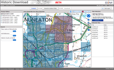
Launched as a BETA service on 20 April 2010, Historic Download is an entirely new facility allowing users to select and download larger quantities of historical map data.
The facility offers the capability to browse contemporary maps of the UK which have been shaded blue to indicate the coverage of historical maps of each series and edition. Areas of historical maps can be selected for download by clicking on the appropriate shaded polygons or by dragging a box to select multiple map sheets.
The interface has been designed to improve selection and retrieval of larger quantities of data for research projects. Build up a list of the data you need, choosing maps from different editions of a given product and take up to 200 maps in a single download.
EDINA welcomes feedback on this BETA service. You can contact us on edina@ed.ac.uk or 0131 650 3302.
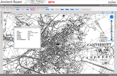
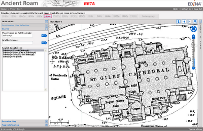
Ancient Roam is a new mapping facility within Historic Digimap. It is based upon the Roam mapping client available from Digimap’s OS Collection and includes the standard features such as fixed scale map views, ‘slippy maps’, searching by place name, postcode and grid reference, easy to use zooming and comprehensive help.
Key features specific to Ancient Roam include the ability to select historical maps from any decade (depending on map coverage and availability) using the Timeline along the top of the map window. Ancient Roam also offers an easier means of identifying and selecting maps in areas where County Series overlap at County boundaries. A single click on the map will also query maps to display the year the map shown was published along with other information about the map.
New Town Plan Maps
The large scale Town Plans are now available to view in Ancient Roam and download from Historic Download. The Town Plans are the largest scale historical maps available from Digimap offering great detail at 1:500, 1:528 and 1:1056 scales. The coverage of these maps is limited in that only settlements with a population greater than 4000 at the time of surveying were mapped. It is interesting to see what were regarded, then, as “urban” areas. The detail captured is enlightening; individual trees are marked in parkland and many industrial and commercial uses of land and buildings are noted.
Beta Service
Currently available as a BETA service, Ancient Roam will continue to undergo development over the coming weeks. Proposed additional functions include:
PDF map creation for printing
My Maps, to enable bookmarking screen maps for future reference
Multiple historical map views, to enable comparison of maps of different dates
Map fade slider, to show transition between maps of different dates
The ability to download the original Map sheet data which makes up your current on-screen map view
EDINA would welcome feedback on the service and on these proposed developments. Please contact us on edina@ed.ac.uk or 0131 650 3302
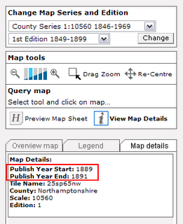
Question: How do I find out what ‘Publish Year Start’ and ‘Publish Year End’ dates means for the maps in Historic Digimap?
Answer: The publishing date range of a map in the Map Details tab from the Main Map View in Historic Digimap. This is achieved by using the View Map Details tool (an i symbol) and clicking on the historic map at the point of interest.
The maps shown on the screen are created from the National Grid “cookie cut” files – images which have been rectified and clipped to create a national grid based “tiled” dataset akin to those available for the contemporary Ordnance Survey data. However, the National Grid does not match up with the County Series maps, because the County Series were created on a per County, rather than a national, basis. It is therefore likely that one “cookie cut” National Grid tile comprises parts of more than one County Series map sheet, each of which could have a different publishing date.
The metadata for the National Grid “cookie cuts” often does not contain one publishing date but the range (from, to) of publishing dates of the Orginal mapsheets which make up that national grid cookie cut tile. It is this range which is reported under the Map Details tab.
Unfortunately, EDINA does not have any survey dates for the maps in the Historic Digimap. Landmark Information Group who provided the maps did not capture the survey dates when the maps were digitised (scanned). This is because the maps were originally digitsed for a specific purpose which did not require the information held in the marginalia of each map sheet. During the digitisation process the marginalia was trimmed from the resultant files, meaning that it was never captured in digital form.
A solution to this is to visit a library which holds historic maps; many university libraries have historic map collections with specialised cartographers and support staff. The map details taken from Historic Digimap can be used to search for and locate the map(s) corresponding to your area of interest. Once found, it is in a map’s marginalia where you can find the recorded survey dates.
More detailed information about historic maps and Historic Digimap can be found in the Help pages.
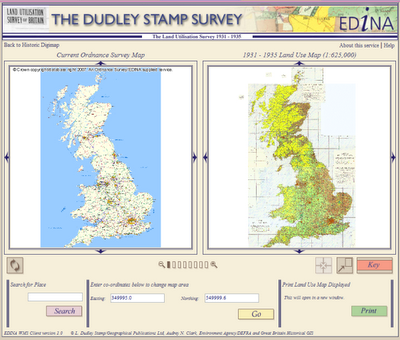
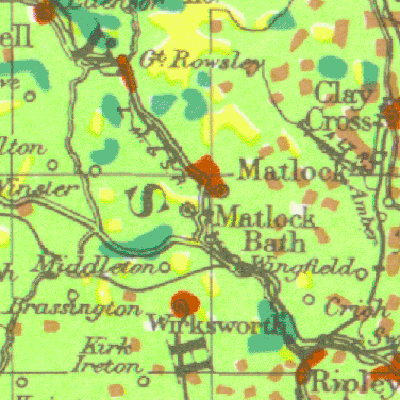
You may have seen a recent episode of Andrew Marr’s BBC programme Britain from Above which featured the Land Utilisation maps created by Dudley Stamp in the 1930s. You can watch the relevant section again on the BBC website here.
Land Use Viewer interface
These maps are available through Historic Digimap under the Land Use Viewer. You need to have a subscription to Historic Digimap in order to gain access, but there is no individual user registration.
Reminder of new licence agreement
A new, three-year sub-licence is now available for Historic Digimap, the service offering historic Ordnance Survey maps and data from the Landmark Information Group. Current subscribing institutions will be contacted directly to ensure continued access from 1 August 2008 onwards. The new licence will run from 1 August 2008 until 31 July 2011. Full details, including subscription forms and costs, can be found on the JISC Collections website at: http://www.jisc-collections.ac.uk/catalogue/coll_digimap_historic.aspx
Trials
In addition, 30-day trials are offered to those from institutions wishing to assess the service prior to subscription. Please contact the EDINA Helpdesk on edina@ed.ac.uk to request such a trial. You can read more about Historic Digimap on the EDINA website at: http://edina.ac.uk/digimap/description/historic_overview.shtml
Consultation on additional datasets
JISC Collections are currently running a consultation for the purchase of additional datasets for Historic Digimap. Among the suggested purchases are the GOAD Fire Insurance plans and historical town plans.
Representatives from existing institutions and others interested in the Collection are invited to complete the short survey at their earliest convenience. This can be done online, and should take only a few minutes to complete:
If your institution subscribes to Historic Digimap, you should note that the current licence ends on 31 July 2008 and the new licence begins on 1 August 2008. Subscription costs for the next licence period are now available from JISC Collections website.
All subscription forms should be completed and sent to the JISC Collections Helpdesk. Details of the subscription process can be found on the JISC Collections “how to subscribe” page.
Please do not send subscription forms to EDINA.
Note also that from 1 August 2008 access to Historic Digimap will be via the UK Federation and OpenAthens.