Geology Roam gets enhanced print maps and a new Active Legend.

We have been working on a few improvements to Geology Roam and have now added rock labels to print maps and a new beta active legend.

Print Labels

The print labels show the lexicon code for each of the rocks on the map, therefore allowing you to identify them on a paper map and distinguish rocks with similar colours. The codes are placed in the centre of the area of each rock, if the rock area lies at the edge of the map then they are place in the centre of the area shown.

The labels are added by checking the box on the Print Map page. Below is a sample of what the maps look like, click on the thumbnail to view a full size image:

Geology PDF showing labels

There is more information about the map labels in the printing section of the Geology roam help:

How to use Geology Roam: Printing

If you are using Safari use the following link and then use the index to get to the Printing section:

How to use Geology Roam

Active Legend Beta

The active legend allows you to reorder the entries in the legend alphabetically or by the number units of that rock type.  You can also click on the map to highlight rocks which will then be identified in the legend, this process works in reverse too, highlight rock on the map that have been selected in the legend. This functionality is still a beta version and we hope to extend the range of options available in the future. The image below shows the active legend at work, click on the thumbnail to view the full size image.

Active Legend in Geology Roam

Instructions on how to use the Active legend can be found in the Geology Digimap Help pages:

How to use Geology Roam: Active Legend

If you are using Safari use the following link and then use the index to get to the Active Legend section:

How to use Geology Roam

Changes and Additions to Digimap on Tuesday 17th May

Digimap will be ‘at risk’ between 17:30 and 18:30 on  May 17th to allow for some service changes and improvements to be made. Access to the service will have to be disrupted intermittently during this period as we add in some new features and make some software upgrades.  We apologise for any inconvenience caused and hope that you find the new additions useful.

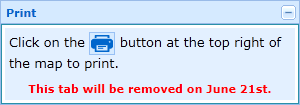
Along with new features being added on the 17th of May all print requests from Digimap Roam and Geology Roam will have to be made using the print button  Print Button at the top right of the map. We will be removing the print tab from the list on the left of the map on June the 21st, but until then it will carry instructions on where to find the print button.

Print Tab

We are removing the tab to make room for the new features we are planning to add into the list on the left in the future.  You may have noticed that it is already getting a little crowded in Geology Roam, with Geology Photos and an Overview Map being added since the service was launched, and there are more additions on the way.

Geological Photos in Geology Roam

Geology Roam now allows you to view British Geological Survey images (of geological features, rocks, fossils and the BGS at work) from the JIDI Image Collection. The images area accessed via the map interface when you are zoomed in to the most detailed geology maps.

There are over 3000 images mainly found in geologically rich areas such as Cumbria, North and South Wales, the Dorset coast, Edinburgh etc. The images cover a wide range of features from details of bedding planes and large crystals in rock faces to aerial photographs of valleys showing glacial erosion features.

To access the photos go to one of the 5 most detailed zoom levels in Geology Roam and click on the camera icon in the tool bar or Geological Photos tab. You can then pan around the maps till you find an area with some photos.

The photos are marked on the map at the location they were taken from; click on the markers to see thumbnails of the image(s) for the location. You can view a full sized image with detail about what is shown by clicking on the thumbnail.

These photos are useful for geologists but there are also some spectacular landscape images that can be enjoyed by everyone.

Geology Roam – new mapping tool

EDINA has released Geology Roam; a new mapping facility within the Geology Digimap Collection. Geology Roam is based upon the Roam mapping facility from Digimap’s OS Collection and includes standard features such as fixed scale map views, ‘slippy maps’, map content customisation, searching by place name, postcode and grid reference, bookmarking and comprehensive help.

Geology Roam contains BGS DiGMap-625, DiGMap-250 and DiGMap-50 geology datasets and Ordnance Survey backdrop mapping. The geological data includes bedrock, superficial deposits, mass movement and faults.

Key features of Geology Roam include the ability to decrease/increase the opacity of the geology data over the Ordnance Survey back-drop map. A single click on the map will query the geology data and display details about the bedrock and any superficial deposits found at that point.

Geology Roam features a new printing interface that will become standard in all the Roam mapping facilities across Digimap. The new printing interface enables you to resize and reposition the map, and to add a map title and National Grid lines.

Beta Service
Currently available as a BETA service, we encourage you to give us feedback on the usability of Geology Roam so that issues you raise can be factored into ongoing development over the coming months. As well as responding to any issues you report, the following additional functions will be introduced:

  • Geological area (polygon) highlighting when clicking to obtain feature information, to make it easier to identify the extent of any geological feature to which the reported information corresponds.
  • Map based links to a Geology Photography Collection (JIDI Images). Icons will appear over the geology maps to indicate the availability of geological feature photographs for that location. Click on the icon to view these photographic images within the Geology Roam application.
  • Introduction of the BGS Rock Lexicon as an Independent application Geology Roam will run in parallel with the existing Geology Mapper during the Beta phase, after which Geology Mapper will be withdrawn (Dec 2010).

The existing mapping application will be withdrawn in December 2010 and will be wholly replaced by Geology Roam.

EDINA would welcome feedback on the service and on these proposed developments. Please contact us on edina@ed.ac.uk or 0131 650 3302.