Any views expressed within media held on this service are those of the contributors, should not be taken as approved or endorsed by the University, and do not necessarily reflect the views of the University in respect of any particular issue.
Digimap is an online map and data delivery service, available by subscription to UK Higher and Further Education establishments. Operated by EDINA at the University of Edinburgh, Digimap offers a number of data collections, including Ordnance Survey, historical, geological, aerial photography, LiDAR, marine maps, land cover mapping, global mapping and census data. For more information about Digimap go to our website: https://digimap.edina.ac.uk Background image Contains OS data (c) Crown Copyright and database right 2022
Eddie Bulpitt, GI Developer/Consultant at Ordnance Survey
Nick Groome, External Research Manager at Ordnance Survey
Digimap would like to invite you to join us for an illuminating session where you will be introduced to Digimap’s Ordnance Survey data and AddressBase, alongside the OS National Geographic Database (OS NGD).
Date: Feb 27, 2024 Time: 01:00 PM London Registration Link:Register Here
Digimap is happy to announce the Aerial Collection’s webinar Getmapping: Digimap Datasets, Presented by Jake Lauder, Account Manager at Getmapping Ltd.
Learn how Digimap and Getmapping team up to provide amazing geospatial data.
Explore the vast range of datasets available through Digimap
Learn how to leverage aerial imagery for your projects
Gain insights into the latest advancements in geospatial technology
Perfect for GIS pros, researchers, or anyone interested in maps and data.
Date: 29 February 2024
Time: 1:00 PM
You can register Here
Digimap is happy to announce the Environment Collection’s webinar ‘The Land Cover Map Family: Land Cover, Crops and Hedgerows’. Presented by Dr. Clare Rowland Earth Observation Scientist and Emily Upcott Spatial Ecologist.
Date: 06 February 2024 Time: 1:00 PM You can register Here
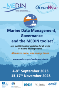
The Marine Environmental Data and Information Network (MEDIN) and OceanWise are delighted to announce two new 2023 course dates for our free online workshop: Marine Data Management, Governance and the MEDIN toolset.
The courses will take place on the following dates:
13th – 17th November 2023 (email roswri@noc.ac.uk to be put on the waiting list to be notified when registration opens).
The course takes place over 5 days with live lessons in the morning and independent learning in the afternoons.
The course can be taken as a whole, or attendees can select modules according to two streams: Marine Data Governance; or Practical MEDIN. Some modules are common to both streams, for example, modules on marine data management principles and components.
The Marine Data Governance stream consists of some elements of general data management best practice, suitable for anyone wishing to improve their data management skills; as well as some higher-level elements suitable for those wishing to enact wider improvements to data management practice across a team or organization.
The practical MEDIN stream also contains elements of general data management with a focus on tools that MEDIN use to facilitate good data management and governance. The practical side to this stream aims to familiarise attendees with creating MEDIN compliant data and metadata.
The course features interactive training and discussion sessions, quizzes, and assignments to help users become familiar with:
Why data management is important and how it can and arguably should be part of an organisations business management framework alongside quality, occupational health and safety, and information security.
The role of a data policy and management plan, and how data can be shared, published, and re-used.
Data management principles, standards, and components, including data lifecycle and quality, the role of vocabularies (or data dictionaries) and the importance of creating, maintaining, and publishing metadata.
The resources and other benefits of MEDIN and practical instruction in the use of the MEDIN data guidelines, metadata standard and controlled vocabularies.
How data management ‘best practice’ can improve organisational efficiency in data acquisition, analysis, curation and sharing. It covers data use with respect to corporate risk, re-use, audit, and traceability, whilst at the same time helping minimising costs.
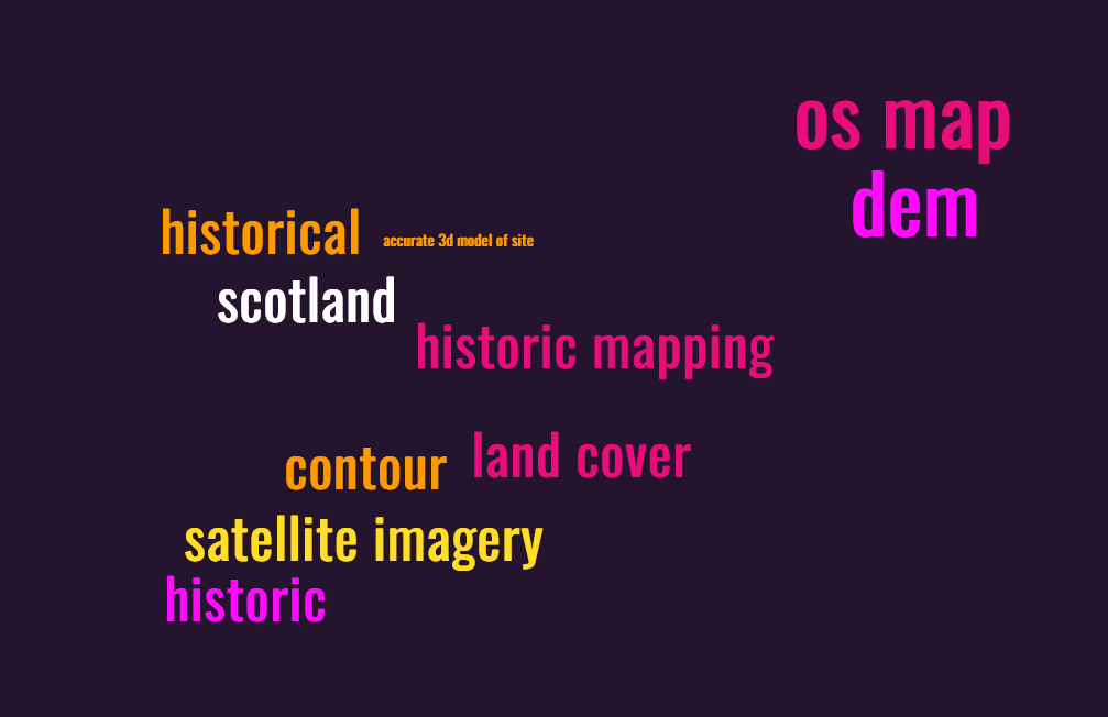
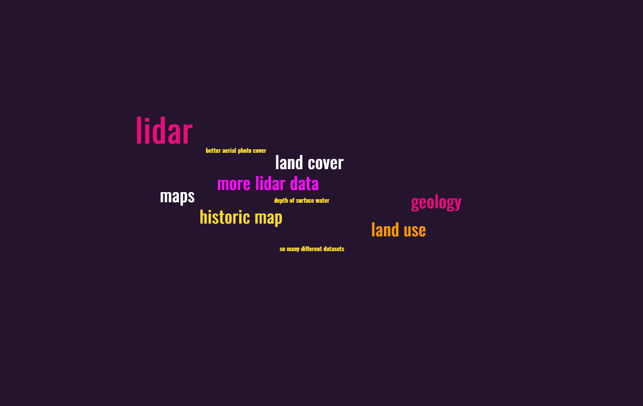
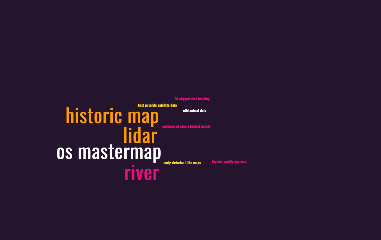
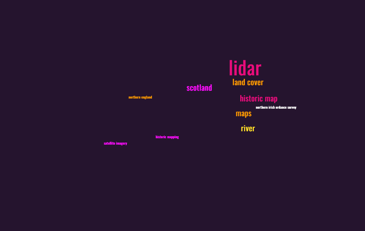
Following our survey in April to learn more about Digimap users’ data priorities for the future, we have some interesting results, with common themes emerging.
First priority datasets:
Second priority datasets:
Third priority datasets:
Combined, the three priorities look like this:
In summary, we think there is demand for more lidar data, more historical data and satellite imagery. We will continue to look at the detail of the survey and use the results to inform our pursuit of additional datasets for Digimap.
In the meantime, do explore what’s already there. Your institution may not subscribe to all the Digimap Collections but you can express your interest in those you don’t currently have access to by logging in to Digimap and following the prompts against each Collection. There is already a range of historical maps (OS, dating back to the 1840s), aerial photography (as much as is available from Getmapping Ltd at 25cm resolution) and Lidar data (originating from GB environment agencies), as well as a full range of DTM and DEM data, detailed OS topographical maps and land cover information. A complete list of all the data available can be found in the Digimap help pages: https://digimap.edina.ac.uk/help/our-maps-and-data/
The UK Hydrographic Office has announced the phased withdrawal of its paper charts to conclude in late 2026. This withdrawal includes digital facsimiles of its paper charts known as raster charts. These are currently available through Marine Digimap‘s Chart Roam and Marine Download applications.
EDINA is aware that the Raster Charts are very popular. As a consequence of the Hydrographic Office announcement, OceanWise (who supply the marine data available through Digimap) is urgently considering how best to support users of the Raster Charts and Raster Charts XL following their withdrawal. One option is to develop alternative raster charts through various means. You can read more about OceanWise’s approach to this on their website.
As a supplier of marine data to the academic sector, EDINA would like to gather feedback from Digimap users about the marine mapping requirements of the research and teaching community to feed into OceanWise’s review of the forthcoming change. If you would like to share your views on this, please drop us a line on digimap@ed.ac.uk
EDINA are pleased to announce the release of new sample data to Pilot Digimap. From 12th January 2023 until 31 July 2023, the following data from Getmapping plc will be available for these sample areas:
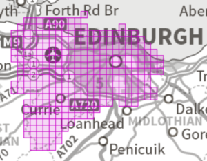
EDINBURGH – Digital Surface Model (2m)
EDINBURGH Digital Terrain Model (2m) – download only
EDINBURGH – Colour Infrared Imagery (50cm)
EDINBURGH – Colour Infrared Imagery (12.5cm) – download only
EDINBURGH – High Resolution Vertical Aerial Imagery (12.5cm)
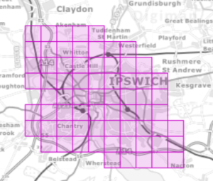
ISPWICH – City View High Resolution Imagery (5cm)
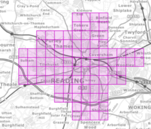
READING – City View High Resolution Imagery (5cm)
City View (5cm) aerial photography, Ipswich
City View (5cm) aerial photography, Reading
High Resolution Vertical Aerial Photography (12.5cm),
Colour Infrared (12.5cm and 50cm), DSM and DTM (2m), Edinburgh
Images contain OS data (c) Crown Copyright and database right 2023
Digimap’s Pilot Collection provides access to data that we would like to evaluate against demand from the Digimap user community. Only sample areas are available through Pilot Digimap, but should demand for the data warrant it, we will explore options for longer term licensing solutions. This means that the data are only available for a short time: January to July 2023.
Please take a look at the data in Pilot Digimap and rate the datasets you would like to see available in future. Please also contact us if you have any questions or would like to discuss any potential future use of these datasets: digimap@ed.ac.uk