Any views expressed within media held on this service are those of the contributors, should not be taken as approved or endorsed by the University, and do not necessarily reflect the views of the University in respect of any particular issue.
Digimap is an online map and data delivery service, available by subscription to UK Higher and Further Education establishments. Operated by EDINA at the University of Edinburgh, Digimap offers a number of data collections, including Ordnance Survey, historical, geological, aerial photography, LiDAR, marine maps, land cover mapping, global mapping and census data. For more information about Digimap go to our website: https://digimap.edina.ac.uk Background image Contains OS data (c) Crown Copyright and database right 2022
Update 12/02/2015:The contents of this blog post have been moved to the Digimap Help system and can be found at the following location (link opens in a new window):
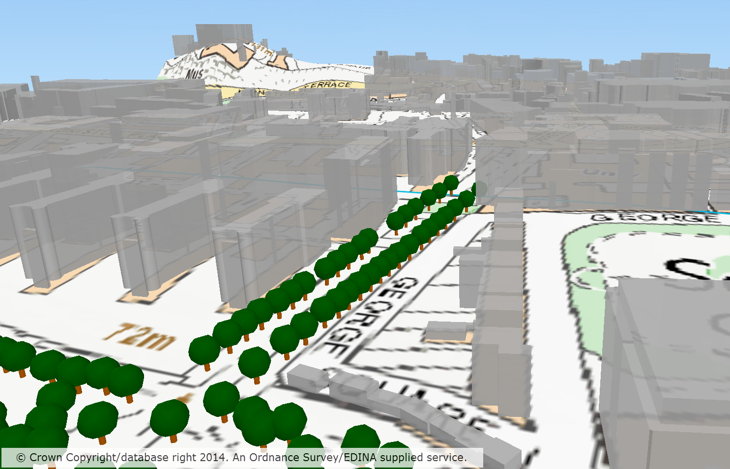
OS VectorMap® Local Raster draped on top of OS Terrain™ 50, with buildings from OS MasterMap® Topography Layer Building Height Attribute and Positioned Non Coniferous Trees extruded on top
To get the most from OS MasterMap data it is usually best to convert it from its supplied format, GML, to a format better suited to the software you are going to use it in. For our CAD users Digimap has been offering the DWG format for several months (see previous blog post); now we are offering a format that makes the data easier to use in GIS software.
Although Shapefile is still the most commonly requested GIS format it cannot handle the large file sizes (over 2GB) that could be requested from the Data Download service; an area of 100km2 in an urban centre would exceed this limit. We therefore turned to the File Geodatabase format that works in the two most commonly used GIS software applications, ArcGIS and QGIS. There is more information about Geodatabases on Wikipedia here: Wikipedia -ArcGIS Geodatabase
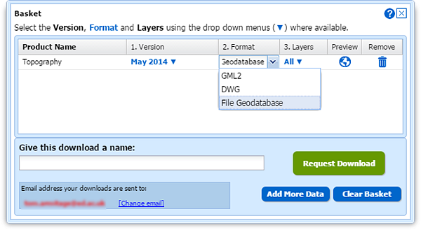
To select the File Geodatabase format, add some MasterMap to your basket in Data Download. Once in the basket you can click the down arrow in the Format column and change it from the default GML to File Geodatabase:
Geodatabase formats are the recommended formats for use in ArcGIS software, being the most efficient for data storage and analysis. The format supports the use of .lyr files for styling the data and EDINA has provided some for the MasterMap data downloaded from Digimap.
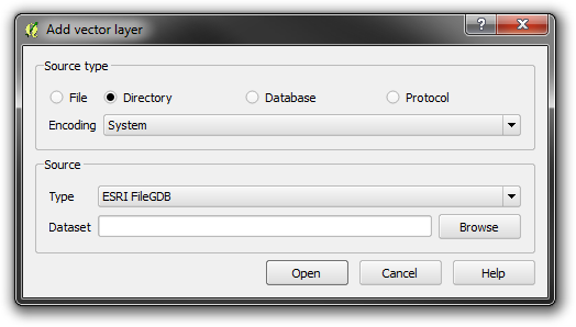
The data can be added to a map in ArcGIS and QGIS in the usual way, though in QGIS you need to use Add vector layer –> Directory rather than a Database as you may assume.
Styling information for both ArcGIS and QGIS has been provided by EDINA in .lyr and QML formats, these can be found at the bottom of Digimap’s help page for OS MasterMap. These representations give enough information to view the data in a style that OS MasterMap is commonly viewed in. The help page also contains a link to the official Ordnance Survey SLD styling information, please see the PDF that comes with the SLD files for information on how to use them.
Update 12/02/2015:The contents of this blog post have been moved to the Digimap Help system and can be found at the following location (link opens in a new window):
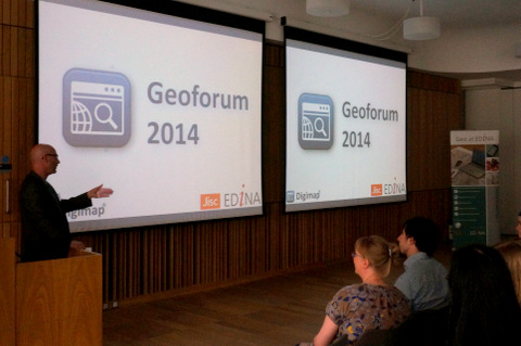
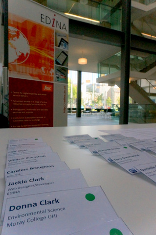
EDINA’s Geoforum 2014 was a great success with an audience of around 80 delegates and EDINA staff all enjoying an informative and entertaining programme. The aim of the event was to engage with users and support staff and highlight new features in EDINA’s core Jisc funded services.
There is a Storify of all the tweets about the conference here: Geoforum 2014 Storify
Keynote Address
Peter Gibbs is a well known for his BBC and Met Office weather forecasts and in his presentation he showed us the work that was being done by the Met Office and Environment Agency in combining their data and resources to predict not just where there is going to be rain but where the rain is likely to cause flooding.
Peter has a keen interest in improving public levels of understanding of science through better communication and this was very evident in his presentation. He managed to explain the complexities of how weather data was collected and used for forecasting in a very accessible way, leaving the audience with a much better understanding of how our weather and in particular flooding is predicted. We also got to see just how much data the met office use, up to 70 recordings at different heights for grid cells up to 1km2.
A key message implied in Peter’s talk was the critical importance of be able to create usable and appropriate information for your audience from the large amounts of complex and varied data available. This is something that as scientists we should all aspire to.
Data Usage
The next presentation came from a recent MSc in GIS Graduate, Darius Bazazi. The presentation followed on from the keynote nicely as it show how various datasets, some from Digimap, some from other sources, were combined to improve the science behind panning natural measures to control flooding. The slides for this presentation are available here:
The main issue tackled by Darius was to improve a key variable that decides whether an area is suitable for natural flood management, PROPWET (the proportion of time soils are wet). Darius used datasets such as the Centre for Ecology and Hydrology’s Landcover data to try and improve this value, bringing in vegetation cover and land use as factors that could influence it.
Darius’ talk showed how important the availability of data from a wide range of sources is key to research such as his. A large amount of researchers time, from graduate level upwards, can be taken up by finding and requesting / ordering data; Digimap and other geoservices from EDINA exist largely to reduce or eliminate the wait for data.
Support
Carol Blackwood finished off the morning’s presentations with a talk about the improvements EDINA are making to the support of their geoservices. The slides for this presentation can be found here:
Carol first told us about the work under way to replace the registration system for the Digimap collections. The main piece of good news is that there will no longer be a wait between registering and accessing the service. The new system will use the familiar email confirmation link to allow access once the registration form has been filled in. This will ensure that users have speedier access and also that their email is correct for collecting their downloaded data.
Carol also highlighted a few other things we are doing to support our users and also to improve the information available for site reps to promote Digimap. Firstly there is the new live chat system that allows people to have a text chat with the user support team. The chat window can be accessed from any of the help pages or the resource centre where it appears as a pop-up:
Finally Carol talked about the training offered by the Geosupport team, if you are interested in attending or hosting a training course then please get in touch with us: edina@ed.ac.uk. We can also arrange to do some bespoke training workshops or webinars for certain subject areas.
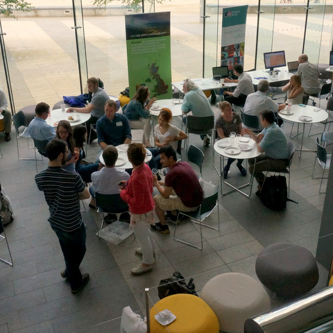
Lunch
During the lunch break we were treated to some delicious food and got to see some interesting data and software from the following people.
Most importantly we were given plenty of time to speak to others at the event, sharing ideas and thoughts on the presentations and demonstrations we had seen.
Service Updates
Guy McGarva brought us up-to-date with all the latest additions and enhancements made to Digimap over the past year, and then went on to highlight the improvements we will be introducing next. The slides for this presentation can be found here:
Guy showed how we are now using the results from the impact surveys and other contact with users to guide and prioritise the developments to the service. He also highlighted the huge amount of work that has gone on in the past year to the back-end architecture of the service that will make it much more reliable, maintainable and flexible going forward.
In the near future you can expect to see a new Download interface for Marine, after which will follow a similar upgrade to Historic Download including a better basket for all the downloaders, where you will be able to select data formats and dates more easily.
Have a look through the slides to see more of the upcoming improvements to the Digimap Service.
Mobile
The last part of the day was a welcome trip outside in the sunshine to see how Fieldtrip GB could be used for Citizen Science projects. The slides for this presentation can be found here:
Addy Pope led the group through an exercise where a form was designed to collect data about graffiti which was then deployed to the groups smart phones and tablets. Everybody then took their devices outside and began collecting data such as photos and the type of graffiti found. The devices take care of logging the location, though the app does allow you to modify this if it isn’t quite right.
Fieldtrip GB had some glowing praise from the delegates, everyone seemed to find the it intuitive and. easy to use. A very good way to crowd source data without an expensive outlay.
Final Summary
A very big thank you to all those who attended Geoforum, we at EDINA feel it was a tremendously successful event.
The days presentations an exhibitions told a story, starting with the importance of geospatial data, especially to bodies of such strategic importance as the Met Office. We heard how research carried out at academic institutions was adding to the accuracy of the data and the models that use the data, and how important access to the data was in order to carry out this research.
The exhibitors showed us the next generation of data along with some of the software to process it. And finally, the presenters from EDINA showed what we are doing to improve the accessibility to the data; not just by making it available but by providing the support and training to realise its full potential.
Jisc continue to provide funding for services such as Digimap, GoGeo and Unlock which form the backbone of geospatial services available to the academic community in Great Britain. The Geoforum allows funders and service providers to engage with the user community which in turn helps focus service improvements.
A final thank you to everyone who helped make the event happen, the EDINA staff who helped organise, present and pack away all the equipment; the exhibitors; Bluesky Catering; and the staff at the Informatics Forum.
Jisc Collections have announced the pricing structure for the Environment Digimap service for the 2014-15 academic year. Environment Digimap will be the cheapest of the Digimap collections with prices ranging from £190 to £500 depending on the Jisc band of your higher education institution. There will be no charge for the service at all for further education institutions. Details of the pricing can be found in the Jisc collections catalogue entry:
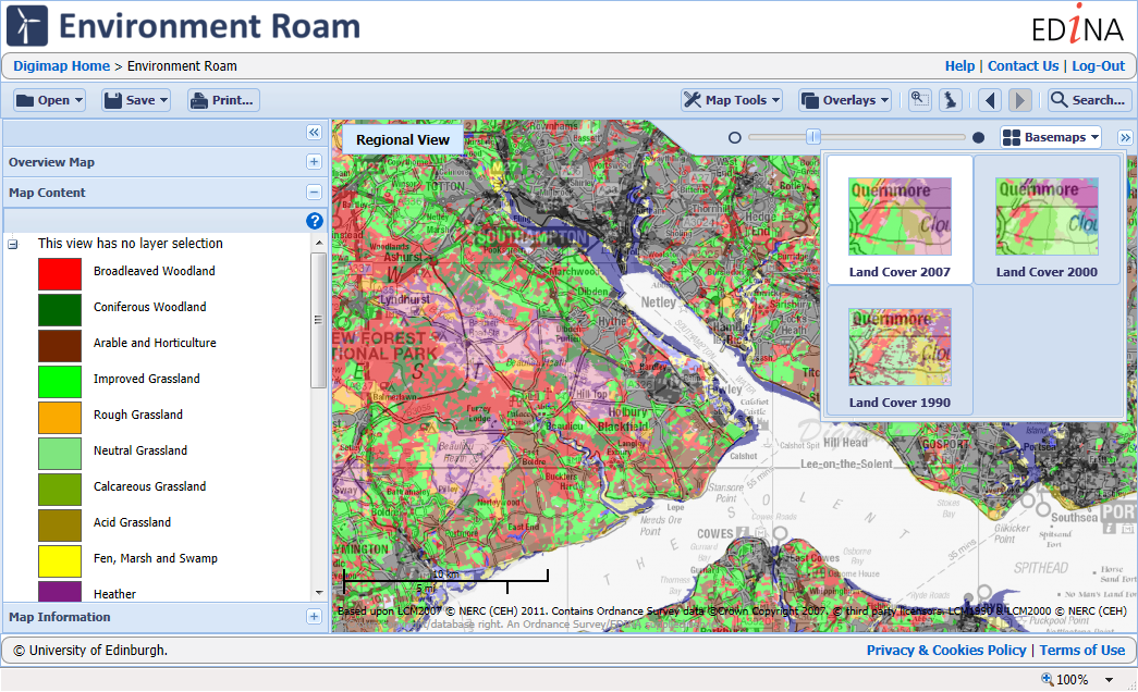
Environment Digimap users have already logged in nearly 7000 times to produce over 90,000 screen maps and download over 3500 tiles of data to use in their research. The service currently supplies the three Land Cover datasets from 1990, 2000, and 2007 from the Centre for Ecology and Hydrology.
While the service provides access to a very import dataset for environmental research, we hope to continue to develop the service in line with the demands of its users. In response to feedback in the current Environment Digimap Survey we will be introducing a map information tool. We have also already added Northern Irish data due to requests from users and hope to make the detailed 2007 Land Cover data vector data available to those who subscribe to both the Environment and Ordnance Survey Digimap collections.
If you have any questions or feedback about the service then please let us know:
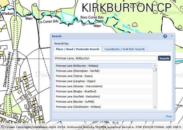
Until now, Digimap has always used the 1:50 000 Scale Gazetteer to provide search results when using the interface.
We have now added street names to the search results in Roam, so you can get more detailed results for your search locations. The locations of the streets come from the OS Locator™ gazetteer which we have been working to include since Ordnance Survey made it an OS OpenData™ product. When using the search interface you can now put in a street name and search for it, though we would recommend adding the name of the place the street is located in too, particularly if it is a relatively common street name. The best results in urban areas are still achieved by using postcodes as these can often resolve to a particular part of the street. However in rural areas where postcodes can be very large, street names can give you the best results.
The search takes all the terms you enter and adds weights to each one; if you enter a full postcode it will just use this to pinpoint your location. If you are not sure your postcode is completely accurate in can be better to leave it out if you have more reliable information. Any street numbers or house names are ignored by the search as these are not stored in the OS Locator or 1:50 000 Gazetteers. The remaining search terms are run against the two gazetteers to produce a list of potential matches.
Be careful when searching for road names that are also places; searching for London Road in Edinburgh will also find Edinburgh Road in London and other possibilities from each city. The weighting usually puts the best match at the top, though you may need to look a little further down the results list sometimes.
We will continue to work on the search abilities in Digimap to improve the results we return, please let us know if you have any questions:
Until now anyone wanting to use OS MasterMap® Topography data in CAD software would have to convert their data, often a lengthy and complicated process. Now you can simply download the OS MasterMap Topography Layer in DWG format directly from Data Download. The DWG data should open in most CAD software such as AutoCAD, Vectorworks and ArchiCAD.
We always knew it wasn’t that easy to convert OS MasterMap data for use in CAD, the conversion software has a lot of options and can confuse at the best of times. The conversion software also doesn’t work on Apple Mac computers which are a popular choice with CAD users. However, we redoubled our efforts to provide DWG format data when we heard that some of our users were making PDF maps of OS MasterMap data and then manually digitising them from the screen… something had to be done!
Incorporating a conversion process into Data Download has not been simple and can produce some very large file sizes, especially if you need data for a busy urban area. Please only take enough OS MasterMap as necessary, or your computer may run out of memory when you work with the data.
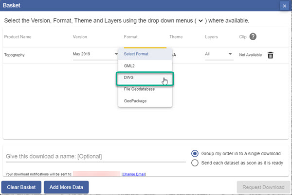
Selecting DWG format
To get your data in DWG format simply follow the usual steps for making an order in Data Download:
Once you have added your OS MasterMap Topography data to the basket, use the drop down arrow in the Format column.
Select DWG format from the available formats.
Selecting a theme and layers
You can select one of two themes for your OS MasterMap topography data. Standard has full colour whereas Plan is in black and white with buildings outlined in red.
Note that you can also choose which layers of Os MasterMap data you wish to download – just select the Layers arrow and check the boxes next to the layers you need, e.g. Buildings, Rail, Roads etc.
Your OS MasterMap data will not need any conversion to open in most CAD software, enjoy playing with the vectors! Please let us know if you have any problems using this data or if you have suggestions as to how it could be improved.
EDINA have added data for Northern Ireland to Environment Digimap after an agreement between Jisc and the Centre for Ecology and Hydrology (CEH) to extend the service beyond Great Britain.
The data comprises of 25m and 1km resolution raster datasets for 2000 and 2007 as well as vector data for both these years. The data shown on the right is the 1KM resolution raster data from 2007.
The datasets essentially classify the land into categories including: sea and inland waters, bare, suburban and urban areas, arable farmland, pastures and meadows, rough grass, grass heaths and moors, bracken, dwarf shrub heaths and moorland, scrub, deciduous and evergreen woodland and upland and lowland bogs. These maps can be used to plan, manage or monitor agriculture, ecology, conservation, forestry, environmental assessment, water supplies, urban spread, transport, telecommunications, recreation and mineral extraction.
The Northern Ireland data is currently available from Environment Download only but will be available in Environment Roam once we have created backdrop mapping and search infrastructure for Northern Ireland.
For details about Environment Digimap and how you can subscribe please see this earlier blog post:
EDINA has added two new datasets to Geology Digimap ahead of the planned release date because of their usefulness when researching floods.
The new datasets have been provided by the British Geological Survey along with several other major products. The Geological Indicators of Flooding and Permeability Indices have been made available from the Geology Download facility early due to the recent flooding events across the UK.
These datasets along with LandCover data from Environment Digimap and digital terrain models, such as OS Terrain 50, from Digimap Ordnance Survey Collection, are all important pieces of information when researching flood risk, causes and potential methods of mitigating against them.
More information about these datasets can be found in the Geology Digimap help pages:
In addition to the two datasets already mentioned there are more new BGS products on the way. You can already download the Superficial Deposits Depth Model and we have the Soil Parent Material data coming soon.
Finally we hope to be integrating the most detailed geological mapping data at 1:10,000 and 1:25,000 scales to both Geology Roam and Geology Download.
If you require any assistance with these datasets or combining them with existing data from Digimap then please let us know:
We are now taking bookings for EDINA’s Geoforum 2014 and with such a fantastic programme this year places could fill up fast. This year’s event will be at the University of Edinburgh in the award winning Informatics Forum, on the 19th June.
Geoforum is a free all day event aimed at lecturers, researchers and support staff who promote and support the use of geospatial data and services at their institution. Throughout the day we there will be talks and demonstrations to inform you of current geospatial developments at EDINA and the wider community. It is also an opportunity to give EDINA feedback on the services we provide and discuss geospatial issues with the team.
For all the details and a full programme please visit the website:EDINA Geoforum 2014
Environment
This year’s theme is the Environment and so we have lined up BBC broadcast meteorologist Peter Gibbs to deliver the keynote. Peter will be talking about the response being taken by the Met Office and Environment Agency to improve flood forecasting.
We also have a recent MSc Graduate talking about his use of LandCover data (available from Environment Digimap) with data from the Scottish Environmental Protection Agency (SEPA) in assessing natural flood management.
Colleges and Further Education
Along with the environmental talks we will also be introducing the upcoming Digimap for Colleges, a new service that sits between Digimap for Schools and the full Digimap service. There will also be an update on all the latest features and enhancements to EDINA’s geoservices.
More Details…
To find out what else we have planned for you, including this year’s excursion, and to book your place please visit the website: EDINA Geoforum 2014


 Peter Gibbs is a well known for his BBC and Met Office weather forecasts and in his presentation he showed us the work that was being done by the Met Office and Environment Agency in combining their data and resources to predict not just where there is going to be rain but where the rain is likely to cause flooding.