Any views expressed within media held on this service are those of the contributors, should not be taken as approved or endorsed by the University, and do not necessarily reflect the views of the University in respect of any particular issue.
Digimap is an online map and data delivery service, available by subscription to UK Higher and Further Education establishments. Operated by EDINA at the University of Edinburgh, Digimap offers a number of data collections, including Ordnance Survey, historical, geological, aerial photography, LiDAR, marine maps, land cover mapping, global mapping and census data. For more information about Digimap go to our website: https://digimap.edina.ac.uk Background image Contains OS data (c) Crown Copyright and database right 2022
All our YouTube videos are now available under the Creative Commons licence. This means that you can copy, distribute and create derivative works from them if you give us credit. The videos are now available in the YouTube video editor so you can use them to help other users or show people what you have learned to do.
For information on what the Creative Commons licence means and how to edit the videos within YouTube go to this web page:
We have been having a play around with the new annotation tools in Digimap Roam here at EDINA, and have come up with a few things you might like to try.
Firstly, you will have no doubt been adding many new features to maps but have you tried taking some away?
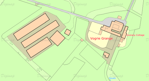
This is the original map area, a MasterMap map showing some large farm buildings to the left of the original farm house. If you had some information about how the area looked prior to their construction you could recreate a map form the past.
The map on the right shows the area after a large green polygon has been drawn over the building area. Make sure you select an appropriate line width and style for the map, and remember to set the opacity to maximum. You needn’t stop there though, you could add buildings on top of the green polygon representing those that had existed previously.
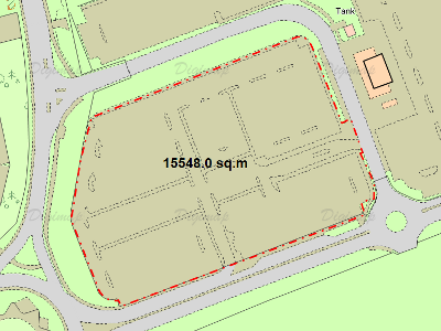
You can also use the annotation tools for some other neat tricks. The image below shows how you can trace around existing features, a car park in this case, and use the measurement tool to work out its area. By making the polygon fully transparent you can then print out your result without obscuring the original features.
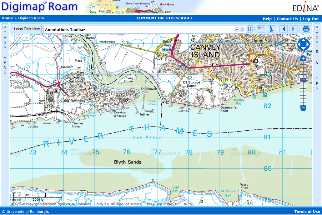
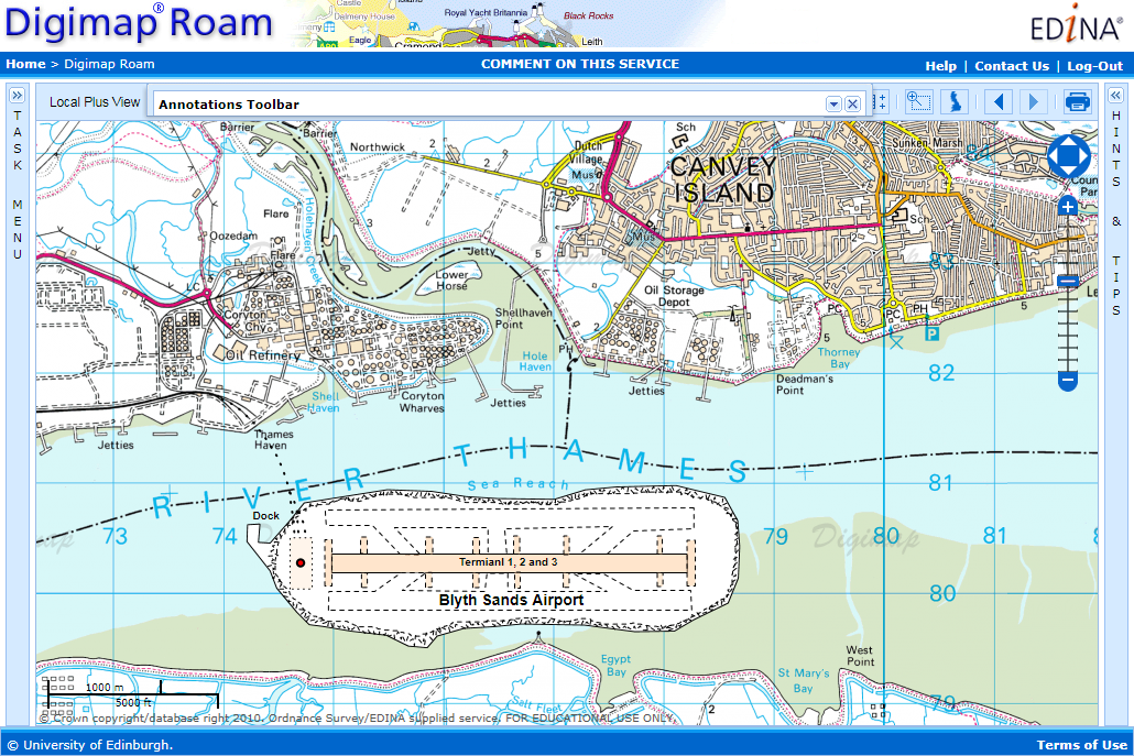
Finally you can use multiple lines and polygons, annotated with text to build up complex new features on the map. The example below shows a proposed new airport in the Thames Estuary:
EDINA has been asked to post the following request for assistance from Ordnance Survey regarding the usability of particular datasets. Please follow the links below if you can help.
You may remember a similar survey being conducted in June 2010. This latest survey refers to different datasets.
Hello,
My name is Michael Brown and I work for the Ordnance Survey research department. My work includes the development and application of methods to improve the usability of OS products. I am currently exploring the use of questionnaires to evaluate the usability of our products and guide their further development. If you have any experience of the following Ordnance Survey products please follow the links provided and complete the questionnaire. Each should only take a few minutes to complete, and I would appreciate it if you could complete as many as you can.
If you have any questions feel free to contact me. Thank you for your time.
Dr. Michael Brown
Usability Specialist
Research, L1F2, Ordnance Survey
Adanac Drive, SOUTHAMPTON, United Kingdom, SO16 0AS
michael.brown@ordnancesurvey.co.uk
Ordnance Survey is currently promoting the GeoVation Challenge with a particular emphasis on the use of OS OpenData. EDINA’s Digimap OpenStream service, providing access to a Web Map Service (WMS) offering OS OpenData products, is available free of charge and can be used to enter the GeoVation Challenge! You just need a .ac.uk email address to register online. Read on for details of the innovation awards funding and prize money.
The current Challenge is “How can we improve transport in Britain?” Check the GeoVation Challenge website for further details. The challenge is open until 12.00 noon on 11 February 2011. If you have a great idea that uses geography to address the challenge, you could win a slice of £150,000 to help make it happen, funded by the Ideas in Transit project. There is also a share of £10,000 for the idea that demonstrates the best use of OS OpenData. The Challenge is open to UK residents 18 and over.
EDINA would like to take this opportunity to remind Digimap users that another of it’s JISC-funded services Go-Geo! (www.gogeo.ac.uk) can save time and effort when looking for geodata. Searches for data can be carried out against a number of catalogues held across government holdings, research data centres and data repositories. Increasingly Go-Geo! offers direct access to the data but if not, it offers the name and contact details of whom to contact to obtain the data. Go-Geo! also offers resource channels which can be browsed for up-to-date news and information on free software, online services, data providers, events and books. For those creating data as part of their studies there’s a wealth of information describing how best to document and describe geospatial data including access to geodoc, a tool for creating standards-compliant metadata. For all your geospatial data needs visit www.gogeo.ac.uk today.
MapAction is a a volunteer-based charity and non-governmental organisation which works in disaster zones providing frequently updated situation maps showing where relief help is most urgently needed.
The earthquake in Haiti has killed all but two members of the Haitian national mapping agency (the equivalent of Ordnance Survey). At Digimap’s 10th Anniversary event on 20th January 2010, Vanessa Lawrence, Ordnance Survey’s Chief Executive and Director General, took a moment to tell of the work that MapAction are doing in Haiti and encouraged donations to this cause.
Donations can be made online directly from the MapAction website: http://mapaction.org/.
There is a lot to know about UK postcodes! Here are some interesting key facts:
There are around 2 million postcodes in the UK, covering something like 29 million addresses.
A postcode is made up of four constituent parts. Take the postcode EH9 1PR as an example:
The postcode Area is indicated by the initial one or two letters: EH
The post District is indicated by the one or two numbers following the Area: EH9
The postcode Sector is indicated by the number after the District: EH9 1
The postcode Unit is indicated by the full postcode: EH9 1PR
Some buildings can contain delivery addresses with different postcodes. High-rise residential buildings are a good example of these. As far as the Code-Point dataset is concerned these are called Vertical Streets, and their boundaries are recorded as regular squares. These are clearly visible when the postcode boundaries are mapped.
Usually postcodes cover around 15 delivery addresses, although this isn’t a hard and fast rule.
Some postcodes apply to only one address or building. Ordnance Survey’s postcode is SO16 4GU. Buckingham Palace also has it’s own postcode, SW1A 1AA, and 10 Downing Street’s postcode is SW1A 2AA. The House of Commons is SW1A 0AA
Postcode unit boundaries (which form the OS Code-Point Polygons dataset) are mathematically calculated around a centroid and are not based on physical boundaries visible on the ground. This centroid is calculated using the coordinates for the delivery points in each postcode. These are not necessarily the precise geographic coordinats of the letterbox in your front door!
The Code-Point dataset offered through Digimap provides much more information than just the postcode and the coordinates of it’s centroid. Additional information includes the NHS Region code, Ward name, how many delivery addresses are in that postcode, how many of those are domestic or business delivery points. The range of information given is different for Scotland from England and Wales.
These enable you to link additional information to the postcode if it is already associated with a code common to the postcode dataset e.g. you can identify which postcodes are associated with data you have collected using Ward codes.
You can use Digimap’s Postcode Query facility (in the Ordnance Survey Collection) to look up the additional information about a particular postcode.
You can use Digimap’s Boundary Download facility to download the Code-Point data and the associated polygons.
Higher and Further Education in the UK already has access to a significant quantity of mapping and spatial data from Ordnance Survey via the Digimap agreement. EDINA is conducting a survey in order to understand more about current academic access to maps and data from other national mapping agencies (i.e. the European equivalents of Ordnance Survey) in other European countries. While we are happy for Digimap users to complete the survey, you can help us further by passing this link on to friends and colleagues within Higher or Further Education elsewhere in Europe: http://tinyurl.com/NMCAUserSurvey Please read on for more details.
*****
Are you are a teacher, lecturer or researcher at a Higher Education Institution in Europe?
Do you use geospatial data (maps, aerial photography, satellite imagery etc.)?
What is the purpose of this survey?
The purpose of this survey is to find out how easy it is for you, as a teacher or researcher, to gain access to the geospatial data sets held by the National Mapping and Cadastral Agency or Agencies in your country. Europe’s Network of National Mapping and Cadastral Agencies (NMCAs) hold and maintain the majority of Europe’s ‘core’ geospatial information including:
topographic data;
cadastral information;
aerial photography; and
land use information and historical map data.
We believe that Higher Education in Europe should be an important market for the NMCAs, as there are around 4,000 Higher Education institutions, with over 17 million students and 1.5 million staff.
With your help, we hope to find out how easy it is to access these data. We will use this information to encourage more NMCAs to make their data available to teachers and researchers in Higher Education across Europe. Our goal is to help you gain access to the quality geospatial data that you need.
Who is carrying out the survey?
Our research team is part of the EDINA National Data Centre, based in the University of Edinburgh, UK. The survey has been endorsed by the Association of Geographic Information Laboratories for Europe (AGILE) and EuroGeographics, which represents 52 National Mapping and Cadastral Agencies from 43 countries across Europe.
When will the survey finish?
The survey will be open for you to complete until Tuesday 21st April 2009.
During this time we would like your help to get as many teachers and researchers as possible to complete the survey. So, once you have completed the survey, please pass on the email and web link to this survey.
JISC Collections has an opportunity to add Ordnance Survey of Northern Ireland (OSNI) data to the Digimap Collections. Before a final decision is made to pursue this agreement JISC Collections would like to guage interest in these mapping data from existing subscribers. JISC Collections would welcome feedback on whether or not your institution would participate in an agreement to supply OSNI data through Digimap Collections.
It has been proposed that the following data be included in the licensing arrangement. The suggested formats are also given for each dataset:
OSNI Largescale Vector (ntf, dxf, dwg)
OSNI 1:50,000 Vector (shapefile, mapinfo tab)
OSNI RegionalMap (pgdb, shapefile)
OSNI GlobalMap (pgdb, shapefile)
OSNI Road Network (shapefile, mapinfo tab)
OSNI Boundary Map (pgdb, shapefile)
OSNI Pointer Product (format: csv) (Pointer includes Royal Mail Group PAF postcodes)
OSNI Place Name Gazetteer Product- OSNI 1:10,000 Raster Product (format: tiff, ecw)
The suggested prices for an institutional subscription to this agreement vary according to JISC’s institutional banding, and are as follows:
Higher Education
Bands A-B – £750 per annum
Bands C-D – £600 per annum
Bands E-F – £400 per annum
Bands G-J – £100 per annum
Further Education
All bands – £75 per institution
If you would find it useful to have access to Northern Ireland data, please contact your Digimap site representative to express an interest in a subscription. If you don’t know who your site representative is, please check the list on our website: http://edina.ac.uk/digimap/list.shtml
If you are a Digimap Site Representative, please gather feedback you receive from Digimap users at your institution and contact Liam Earney (L.Earney@jisc.ac.uk) if you would like to express an interest in a subscription for your institution.
Peter Burrough, one of the founding fathers of GIS research, died in Leiden on 9th January 2009.
Peter Burrough is recognised for his for seminal work, Principles of GIS for land resources management. Published in 1986, the book introduced the essential technical tasks of GIS applications such as spatial data capture, storage, and output, and the development of the analytical models that were needed to exploit the full potential of this new technology. The book became an instrumental resource for soil scientists as well as geographers, surveyors, social scientists, urban planners and students in these fields. As a result many became interested in the newly developing GIS field.
Peter Burrough is also recognised for his important contributions to the creation of both AGILE (the Association of Geographic Information Laboratories for Europe) and to EUROGI (EURopean Umbrella Organisation for Geographic Information) at a critical point in its development.
In January 2007, his role as a founding father of GIS research was internationally recognised in a special issue of the International Journal of Geographic Information Science on Advances in the spatio-temporal modelling of environment and landscapes. This was edited by two of his former colleagues at Utrecht University and the co-author of the second edition of his classic work, Rachael McDonnell.