Any views expressed within media held on this service are those of the contributors, should not be taken as approved or endorsed by the University, and do not necessarily reflect the views of the University in respect of any particular issue.
Digimap is an online map and data delivery service, available by subscription to UK Higher and Further Education establishments. Operated by EDINA at the University of Edinburgh, Digimap offers a number of data collections, including Ordnance Survey, historical, geological, aerial photography, LiDAR, marine maps, land cover mapping, global mapping and census data. For more information about Digimap go to our website: https://digimap.edina.ac.uk Background image Contains OS data (c) Crown Copyright and database right 2022
EDINA strives to provide face-to-face training for Digimap which is appropriate, comprehensive and meets the needs of site representatives in supporting Digimap. To this end, we are conducting a training needs survey, in order to establish how to improve the training we offer for Digimap. The results of the survey will inform a review of current training and will assist us in improving what we offer.
The survey is online and should not take more than two or three minutes to complete. Please click the link below. We welcome your views.
If you have comments you would like to make but can’t find an appropriate place in the survey to do so, please phone us, or email the EDINA Training Officer on edina-training@ed.ac.uk
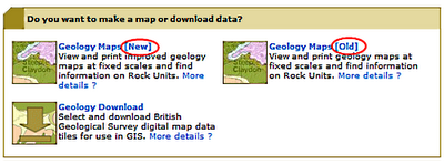
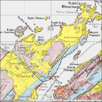
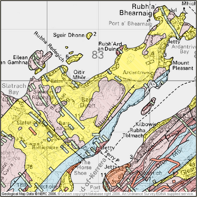
The Geology Maps facility in Geology Digimap has been greatly enhanced by upgrading the technology. The maps now use a transparency technique to represent rock types in colour, rather than hatching. The result has been much clearer maps, more closely matching their paper counterparts printed by the British Geological Survey. It also makes it easier to see the underlying context mapping, as well as identifying which rock types overlay which. Below are some examples of the new colour scheme.
Old and new versions, clearly labelled
The previous version of Geology Maps is still available for those who have become accustomed to it or have created training courses based upon it. This version is clearly labelled “old“. It will be withdrawn at the start of the next academic year (2008/9) when we hope everyone will be enjoying the benefits of the new maps.
New style cartography, using transparency
Old style cartography, using traditional hatching methods
Reminder of new licence agreement
A new, three-year sub-licence is now available for Historic Digimap, the service offering historic Ordnance Survey maps and data from the Landmark Information Group. Current subscribing institutions will be contacted directly to ensure continued access from 1 August 2008 onwards. The new licence will run from 1 August 2008 until 31 July 2011. Full details, including subscription forms and costs, can be found on the JISC Collections website at: http://www.jisc-collections.ac.uk/catalogue/coll_digimap_historic.aspx
Trials
In addition, 30-day trials are offered to those from institutions wishing to assess the service prior to subscription. Please contact the EDINA Helpdesk on edina@ed.ac.uk to request such a trial. You can read more about Historic Digimap on the EDINA website at: http://edina.ac.uk/digimap/description/historic_overview.shtml
Consultation on additional datasets
JISC Collections are currently running a consultation for the purchase of additional datasets for Historic Digimap. Among the suggested purchases are the GOAD Fire Insurance plans and historical town plans.
Representatives from existing institutions and others interested in the Collection are invited to complete the short survey at their earliest convenience. This can be done online, and should take only a few minutes to complete:
Access to all EDINA services, including the Digimap Collections, will be via UK Federation authentication only from 1 August 2008. This can be done either directly through the UK Federation or by using the OpenAthens gateway services.
EDINA has established from publicly available lists that there are some institutions which have not yet indicated which authentication system they will be using from 1 August 2008.
If your institution is not able to authenticate users with one of these methods by 1 August 2008, users at those institutions will lose access to the Digimap Collections. EDINA is not able to provide any alternative means of access, therefore we would urge you to consider which authentication system is most suitable for your institution’s needs.
If you have any questions about access to Digimap, or would like to discuss the implications of this change further, please do not hesitate to contact us. You can reach us by email on edina@ed.ac.uk or by telephone on 0131 650 3302.
The EDINA Helpdesk endeavours to provide a quick reply to all enquiries. An initial response time of one working day is our goal, with an aim to resolve queries completely within 5 working days. However, every effort is made to answer user questions more expeditiously.
Digimap service users can significantly improve the speed with which their queries are resolved by providing detailed information about their problem. The more you tell us, the quicker we can help you find a solution.
What information to include
You should consider submitting as much information as possible, including the following:
your full name and your institution
which Digimap facilities you are using (e.g. Classic, Hydrospatial Download or Geology Maps)
which data you are using (e.g. Land-Form PROFILE or 1:625,000 BGS data)
which location (coverage) for the data in question (e.g. place names, tiles, co-ordinates)
which web browser you are using (e.g. Internet Explorer, Firefox, Opera)
the full text and URL of an error message, if appropriate and possible
perhaps a screenshot, especially for webpages displaying error messages
a detailed description of the problem, and the steps taken which led to it
Submission of these details with your query will make it easier for EDINA to identify and respond to the problem quickly and have you back on track.
Contact Us
The EDINA Helpdesk is staffed between 0900 and 1700 hours, Monday to Friday. You can contact the Helpdesk by email on edina@ed.ac.uk or by telephone on 0131 650 3302.
All Digimap services will be unavailable between 0900 and 1100 hours on FRIDAY 30 May 2008. This is to enable EDINA to fix a further critical problem with the machine which hosts Digimap. Full service will be restored as quickly as possible and updates will be posted on this site, and on the Digimap login page as and when they are appropriate and available.
All Digimap services will be unavailable between 0900 and 1100 hours on THURSDAY 29 May 2008. This is to enable EDINA to fix a critical problem with the machine which hosts Digimap. Full service will be restored as quickly as possible and updates will be posted on this site, and on the Digimap login page as and when they are appropriate and available.
After 1 August 2008 you will need to use OS MasterMap Topography layer instead of Land-Line data. Land-Line is the most detailed data available through the Data Download facility within Digimap’s OS Collection. It has been replaced by OS MasterMap Topography layer, which is equally detailed and available through the MasterMap Download facility.
Two OS MasterMap Layers, Topography and Integrated Transport Network, have been available from Digimap’s OS Collection since September 2007. These layers are available through the MasterMap Download facility. You can read more about OS MasterMap data on our OS MasterMap website and within the Digimap Help pages. Look in the sections under MasterMap Download and Data Information.
There are several software packages available which make the process of loading and viewing the OS MasterMap in GIS applications quite simple, more simple than using Land-Line data, in fact. These are in addition to ‘built-in’ converters supplied with the most recent versions of ArcGIS (Productivity Suite), MapInfo and AutoCAD software.
Viewing data
If you wish to simply view the OS MasterMap data (rather than undertake any spatial analysis, querying or manipulation), there is a simple viewer produced by Snowflake Software. It is called the OS MasterMap Viewer and can be downloaded for free (upon registration) from the Snowflake website.
MapInfo
The following applications are free and will load OS MasterMap, fully represented, into MapInfo:
InterpOSe (Digimap Edition) from Dotted Eyes. This is available free of charge on registration with Dotted Eyes. It includes full OS MasterMap styling, and will convert data to various file formats, including Shape, TAB, mid/mif and DWG/DXF.
ArcGIS
The following applications are freely available:
Productivity Suite 1.1. This is freely available to those licensed to use ArcGIS through Eduserv Chest. It contains MapManager and will convert OS MasterMap to Geodatabase format and comes complete with a number of layer files for representation (details can be found in the local installation folder of Productivity Suite). You will need a special Athens username and password to access the software download area. This should be available from your local Chest Representative or ESRI Technical Contact.
InterpOSe (Digimap Edition) from Dotted Eyes. This is available free of charge on registration with Dotted Eyes. It includes full OS MasterMap styling, and will convert data to various file formats, including Shape, TAB, mid/mif and DWG/DXF.
AutoCAD
InterpOSe (Digimap Edition) from Dotted Eyes. This will convert OS MasterMap to DXF and DWG and has a template file (.DWT) for representing the data using OS style. InterpOSe can be downloaded for free from Dotted Eyes website on registration there.
There are other packages and resources available which are detailed on our OS MasterMap website. Ordnance Survey also provide information about software which will read OS MasterMap data.
Instructions on using MapManager 9.1 and InterpOSe are included in the Digimap Help pages. Look in the section labelled “Using Data with GIS”. If you have any questions about the information provided here, please contact the EDINA Helpdesk on edina@ed.ac.uk or 0131 650 3302.
If your institution subscribes to Historic Digimap, you should note that the current licence ends on 31 July 2008 and the new licence begins on 1 August 2008. Subscription costs for the next licence period are now available from JISC Collections website.
All subscription forms should be completed and sent to the JISC Collections Helpdesk. Details of the subscription process can be found on the JISC Collections “how to subscribe” page.
Please do not send subscription forms to EDINA.
Note also that from 1 August 2008 access to Historic Digimap will be via the UK Federation and OpenAthens.
Are you coming to the end of your course? Are you changing jobs and moving to a different University or College? Are you retiring? If so, there are some issues relating to the use of Digimap which you should be aware of.
IF YOU ARE GRADUATING, OR YOUR COURSE IS COMING TO AN END… …you will cease to be a member of a subscribing institution and therefore will no longer be a Digimap Authorised User. This means you must delete any data you hold from Digimap. You may keep paper maps (including those which form parts of reports, coursework and dissertations), but not digital data.
IF YOU ARE CHANGING JOBS OR MOVING TO A DIFFERENT COLLEGE OR UNIVERSITY…
…you need to check whether your new institution subscribes to any of the Digimap Collections. If your new institution is NOT a subscriber to a particular Collection, you may not retain any digital data from that Collection in your new job. If you wish to use Digimap in your new job, and your new institution is also a subscribing institution, you will need to register with Digimap using login credentials from your new institution.
IF YOU ARE LEAVING AN EDUCATIONAL INSTITUTION AND GOING TO WORK FOR A COMMERCIAL OR CHARITABLE ORGANISATION…
…you will cease to be a Digimap Authorised User. This means you must delete any data you hold from Digimap. You may keep paper copies of maps (including those which form part of reports or dissertations), but not digital data.
WHAT IFS…
There are some circumstances where you may continue to be an Authorised User, even if you are graduating, or leaving your current institution. If you are retiring, you may continue to have rights to access your institution’s electronic resources. If you are graduating from your first degree and staying at the same institution to undertake a PhD, you will continue to be a member of your institution and therefore eligible for access to Digimap. If you believe you should continue to have access to your institution’s resources, you should check with your Digimap site representative whether this applies to Digimap too.
The rules of eligibility apply to all Digimap Collections. These rules revolve around the definition of “Authorised User” as specified in the licence agreement for each Collection. You can find these on the EDINA website at: http://edina.ac.uk/digimap/terms.shtml
A NOTE FOR SITE REPRESENTATIVES… Access to any electronic resource relies on subscribing institutions maintaining authentication and authorisation systems effectively and efficiently. An example of good practice in this regard would be deactivating local user accounts when students graduate or leave your institution. You may wish to check what your local practice is.