Any views expressed within media held on this service are those of the contributors, should not be taken as approved or endorsed by the University, and do not necessarily reflect the views of the University in respect of any particular issue.
Digimap is an online map and data delivery service, available by subscription to UK Higher and Further Education establishments. Operated by EDINA at the University of Edinburgh, Digimap offers a number of data collections, including Ordnance Survey, historical, geological, aerial photography, LiDAR, marine maps, land cover mapping, global mapping and census data. For more information about Digimap go to our website: https://digimap.edina.ac.uk Background image Contains OS data (c) Crown Copyright and database right 2022
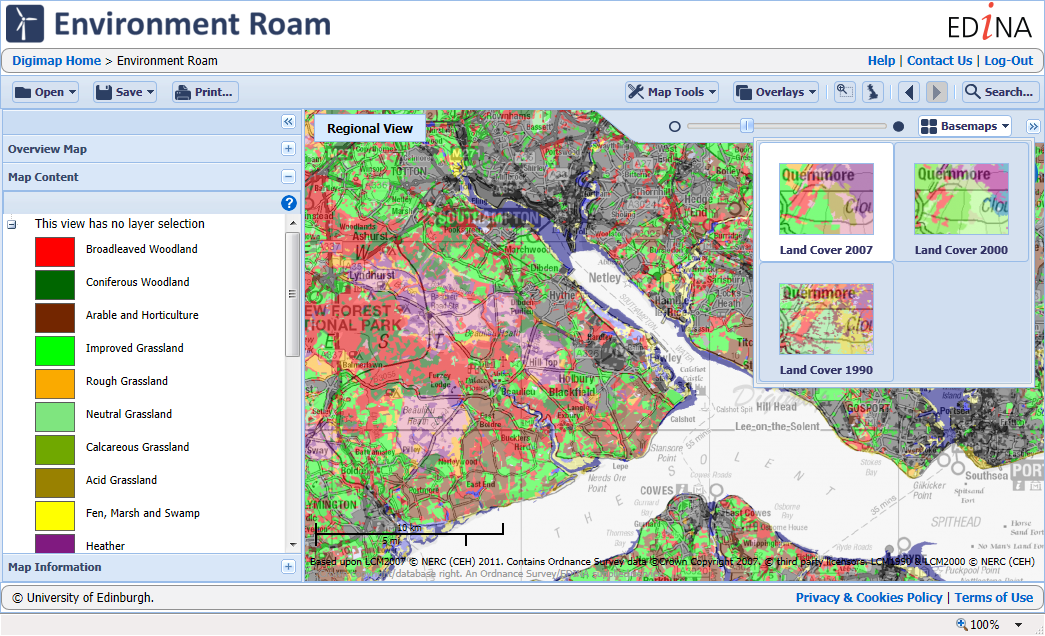
EDINA have added data for Northern Ireland to Environment Digimap after an agreement between Jisc and the Centre for Ecology and Hydrology (CEH) to extend the service beyond Great Britain.
The data comprises of 25m and 1km resolution raster datasets for 2000 and 2007 as well as vector data for both these years. The data shown on the right is the 1KM resolution raster data from 2007.
The datasets essentially classify the land into categories including: sea and inland waters, bare, suburban and urban areas, arable farmland, pastures and meadows, rough grass, grass heaths and moors, bracken, dwarf shrub heaths and moorland, scrub, deciduous and evergreen woodland and upland and lowland bogs. These maps can be used to plan, manage or monitor agriculture, ecology, conservation, forestry, environmental assessment, water supplies, urban spread, transport, telecommunications, recreation and mineral extraction.
The Northern Ireland data is currently available from Environment Download only but will be available in Environment Roam once we have created backdrop mapping and search infrastructure for Northern Ireland.
For details about Environment Digimap and how you can subscribe please see this earlier blog post:
EDINA has added two new datasets to Geology Digimap ahead of the planned release date because of their usefulness when researching floods.
The new datasets have been provided by the British Geological Survey along with several other major products. The Geological Indicators of Flooding and Permeability Indices have been made available from the Geology Download facility early due to the recent flooding events across the UK.
These datasets along with LandCover data from Environment Digimap and digital terrain models, such as OS Terrain 50, from Digimap Ordnance Survey Collection, are all important pieces of information when researching flood risk, causes and potential methods of mitigating against them.
More information about these datasets can be found in the Geology Digimap help pages:
In addition to the two datasets already mentioned there are more new BGS products on the way. You can already download the Superficial Deposits Depth Model and we have the Soil Parent Material data coming soon.
Finally we hope to be integrating the most detailed geological mapping data at 1:10,000 and 1:25,000 scales to both Geology Roam and Geology Download.
If you require any assistance with these datasets or combining them with existing data from Digimap then please let us know:
We are now taking bookings for EDINA’s Geoforum 2014 and with such a fantastic programme this year places could fill up fast. This year’s event will be at the University of Edinburgh in the award winning Informatics Forum, on the 19th June.
Geoforum is a free all day event aimed at lecturers, researchers and support staff who promote and support the use of geospatial data and services at their institution. Throughout the day we there will be talks and demonstrations to inform you of current geospatial developments at EDINA and the wider community. It is also an opportunity to give EDINA feedback on the services we provide and discuss geospatial issues with the team.
For all the details and a full programme please visit the website:EDINA Geoforum 2014
Environment
This year’s theme is the Environment and so we have lined up BBC broadcast meteorologist Peter Gibbs to deliver the keynote. Peter will be talking about the response being taken by the Met Office and Environment Agency to improve flood forecasting.
We also have a recent MSc Graduate talking about his use of LandCover data (available from Environment Digimap) with data from the Scottish Environmental Protection Agency (SEPA) in assessing natural flood management.
Colleges and Further Education
Along with the environmental talks we will also be introducing the upcoming Digimap for Colleges, a new service that sits between Digimap for Schools and the full Digimap service. There will also be an update on all the latest features and enhancements to EDINA’s geoservices.
More Details…
To find out what else we have planned for you, including this year’s excursion, and to book your place please visit the website: EDINA Geoforum 2014
Environment Digimap has been in service for around 4 months now and already has 63 subscribing institutions, over 6000 active users and has made over 35,000 screen maps.
We’d really like to know what you think of the newest Digimap Collection and what you want to see added or improved. Once you have used the service then please go to the following web page and fill in the short survey, it will take less than 10 minutes and will help the future development of Environment Digimap:
If your institution doesn’t subscribe to Environment Digimap yet you still have 4 months where the service is completely free. The following blog post has information on how to subscribe:
For information on how previous Digimap surveys have affected the survey please have a look at the Quality Improvement reports on EDINA’s Benefits of Services page:
We are often asked whether maps from Digimap may be used in submissions for planning applications. The answer is no. This applies to ALL planning applications, regardless of who submits them, to which authority and under what guise. This includes:
students submitting planning applications to a planning authority as part of coursework or work placement schemes
all private planning applications (commercial or residential)
institutions submitting planning applications for their own premises
members of staff who take on consultancy work involving the submission of planning applications
Maps and plans for planning applications can be purchased from many different suppliers. Promap is one such example. There is also a UK government website called the Planning Portal which can assist with plans and maps.
Ordnance Survey are running a one day event for people to show off their cartography skills; anyone who is able to take up a summer internship can apply.
Jenny Brooker, Prototyping Manager at Ordnance Survey writes:
We’ve come a long way since the days of drawing maps by hand but Cartography is still an integral part of our business, and is so much more than just making pretty maps.
We are inviting anyone with an interest in cartographic design or data visualisation to come to Carto Hack Camp and showcase their skills by spending the day with us visualising geographic data. The winner will be offered a paid summer internship in our cartographic design team.
What Will Happen at Carto Hack Camp?
Our camp will be a day-long opportunity for anyone to visit our headquarters in Southampton, meet our Product Development team and spend the day working with them to come up with an exciting new solution for one of our customer scenarios.
There will be a choice of three different customer scenarios, designed to suit a wide range of backgrounds and abilities. The work will be similar in nature to that carried out by our cartographic design consultants. Find out more about what they do here.
You will then demo your ‘map’ to our panel of Ordnance Survey judges who will rate them and decide on the day’s winner.
Why Should I Get Involved?
It’s an opportunity for anyone with skills and an interest in cartographic design to innovate, create and collaborate with other like-minded people.
Our aim is for an enjoyable, relaxed and pressure-free day. Such an atmosphere will hopefully promote good design and if you want to take it a step further, we will be offering the hack day winner a paid summer internship in the Ordnance Survey Cartographic Design team.
Internship
As a part of the British Cartographic Society’s 50th anniversary celebrations last summer, Ordnance Survey announced that we would offer a paid summer internship for a six to nine week period during 2014 in our cartographic design team. The winner of the hack camp will be offered the opportunity to take up this internship.
Where is it?
We will be setting up camp in the business centre at our own headquarters, Explorer House on the edge of Southampton.
When is it?
Thursday 20th February 2014.
9:30 am – Breakfast
10 am – Introduction
1pm – Lunch.
5pm – Round up of the day and judging.
6pm – Finish
What do I Need?
You need a keen interest in cartographic design or data visualisation and preferably some relevant skills but we welcome applicants from any background. You can bring along your own equipment and software, internet access will be provided. If you don’t have your own equipment laptops can be provided on request (please email cartodesign@ordnancesurvey.co.uk with your requirements prior to the event).
How Much Does it Cost?
The event is free and we will provide complimentary food and drink. All we ask is for your time and for you to arrange your own way of getting here.
All Digimap services will be unavailable between 08:30 and 10:00 on Tuesday 28th of January, and should be considered “at risk” for the rest of the morning. We are carrying out an essential database upgrade, this affects logging into the service so there will be no access until the work is complete. We apologise for any inconvenience caused.
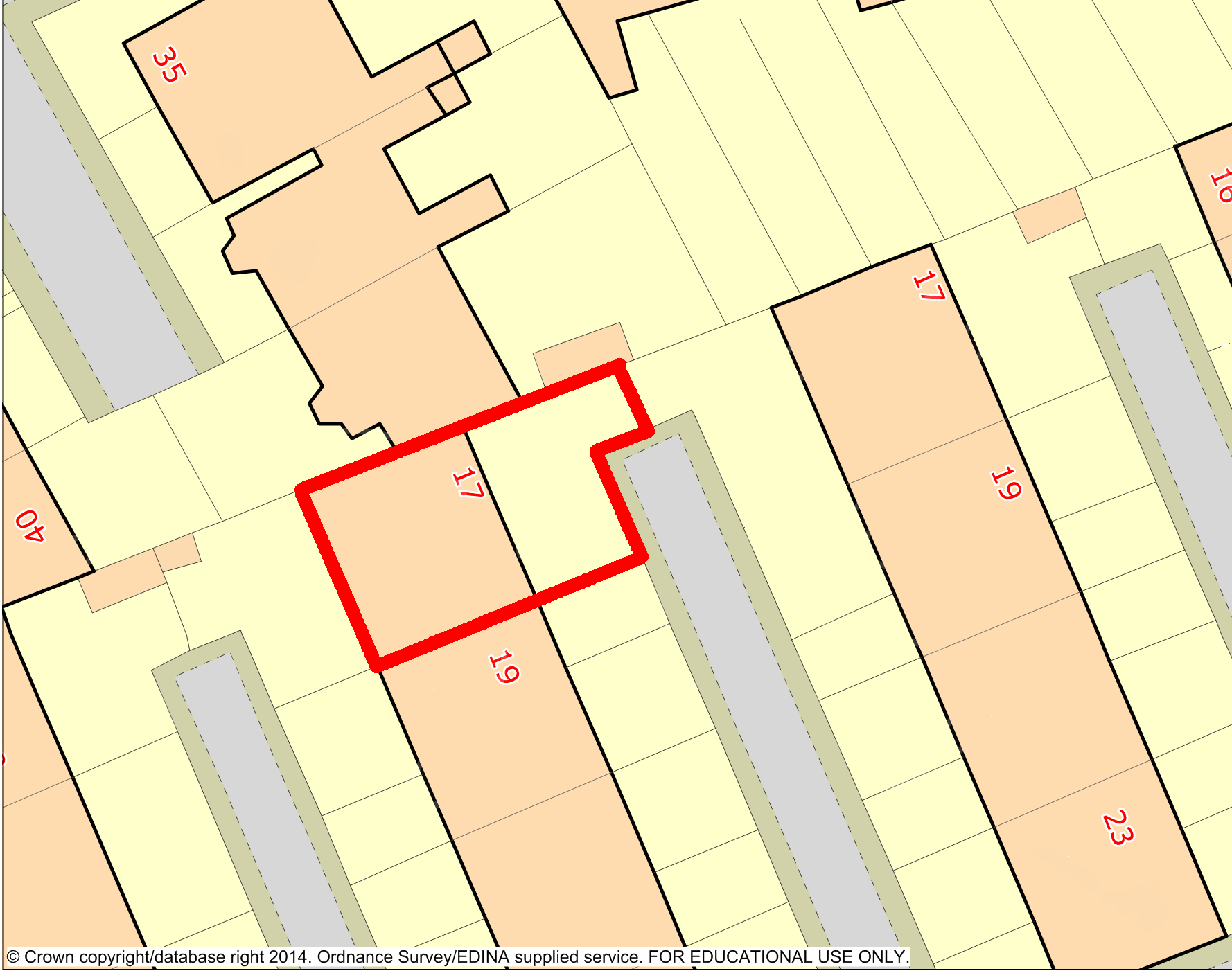
Ancient Roam in Historic Digimap has had its print options updated so it now has the same set of options as the other Roam facilities. The two big changes to note are that you can now print up to A0 and that you can print a single county in areas where several overlap.
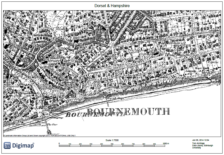
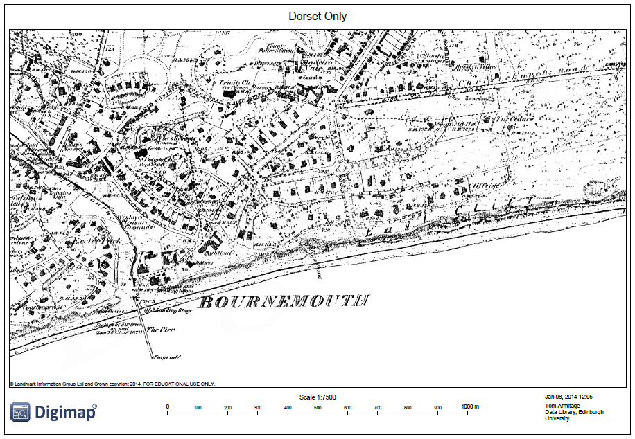
Until this change was made it was impossible to print an area with overlapping maps without printing all the counties available rather than just the one(s) you were viewing on the screen. Any print files now generated in areas with overlapping counties will only show those which are displayed on screen. This allows you to have the control over how much information is on your map and to make the decision to show more or less information.
Sometimes it can be an advantage to show multiple counties as even though the sheets overlap the actual map information doesn’t. However in the example above you can see how the counties overwrite each other in the map on the left and so produce a very confusing and fairly useless result; by switching one county off you can produce a much clearer print map such as the one on the right. [Click on the images above to view larger versions of the maps.]
The ability to print maps up to A0 brings Ancient Roam into line with the other Roam facilities so you can now print at this very large size in any Digimap collection.
EDINA currently uses the time between 17:30 and 18:30 on Tuesdays as its “At Risk” period for carrying out service maintenance to Digimap. From January 2014 we will be changing this to a morning slot, between 08:30 and 09:30 on Tuesdays, allowing us more time to resolve any issues that may arise due to the scheduled work.
Increasingly the maintenance work has been causing less and less disruption to the service as we are able to switch to different servers. Moving to a morning downtime allows us to further minimise any potential disruption because staff are more readily on hand during normal working hours.
We hope that this change doesn’t cause any disruption to our users, please let us know if you have any concerns:

 EDINA have added data for Northern Ireland to Environment Digimap after an agreement between Jisc and the Centre for Ecology and Hydrology (CEH) to extend the service beyond Great Britain.