Space Network Scotland – Global Scale Earth Analytics
Seminar
This week’s EEO seminar, hosted jointly with the Hutton Club, is given by Dr. Callum Norrie of Space Network Scotland. These are exciting times for the burgeoning Scottish and UK Space sectors and this promises to be a fascinating talk looking at wider enterprise within Scotland and connections with academia, also acting as a follow-up to our previous EEO event focussing on the public sector perspective. [1]
Global Scale Earth Analytics – Our Sustainable Opportunity
Dr. Callum Norrie, Space Network Scotland, works with satellite data on a great range of programmes including Envisat, Aeolus, Picasso, Unicorn 2.
Callum has extensive experience in the space industry with over 10 years working at the European Space Agency, latterly as the manager of the ESA Technology Transfer Network. With a PhD in physics and an MBA, Callum has worked in a number of roles including technology development, marketing and business support.
Dr. Callum Norrie – Space Network Scotland
Scotland is part of a wider space network
Where do we source our data?
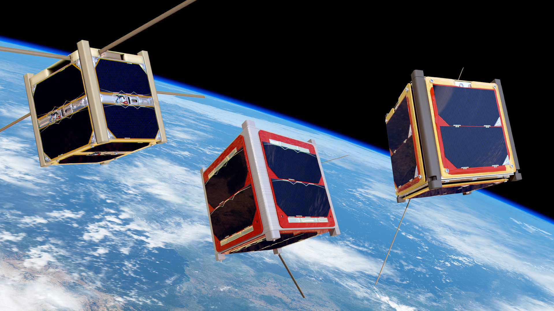
Most of the satellite data is from large scale satellite programmes, mostly employed by government space agencies. Some private corporations emerged as well. Public collaboration is important, such as the company: CubeSats.
A notable example is nanosats.eu.
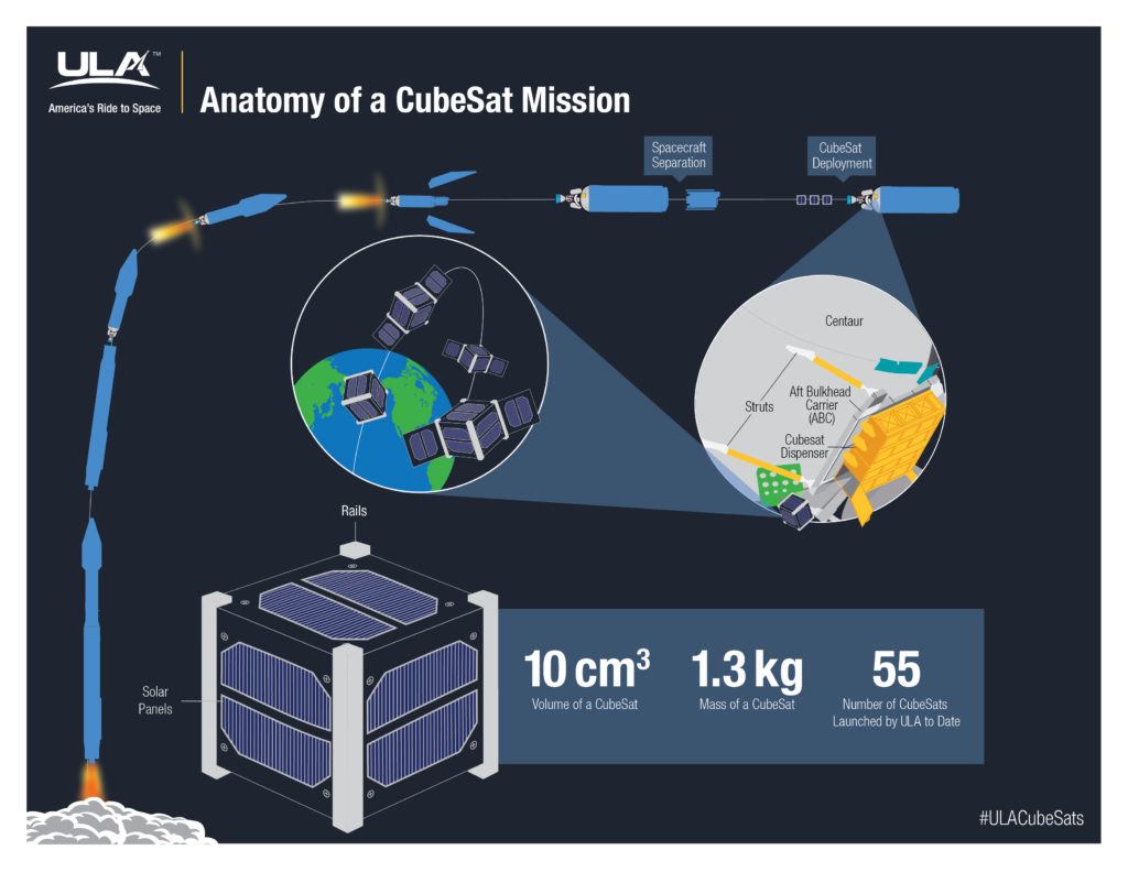
So far, they launched +2500 micro satellites when all the companies are combined, as there are several of them.
Scotland has numerous planned space ports. Unst is a good example with the Shetland Space Centre. Scotland is planning multiple space ports to launch satellites. With government backing the UK is posed to have several launching sites by the end of this decade.
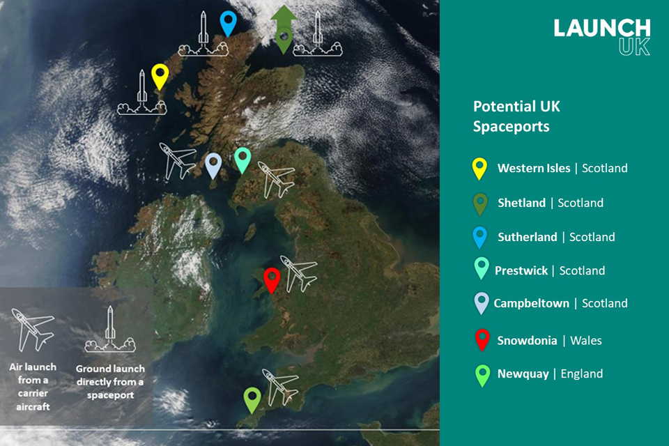
The Shetland Space Centre
SSC plans to build and operate a satellite launch site and a ground station in Unst, Shetland, the UK’s most northerly island. It follows the identification in a major report for the UK Space Agency of Saxa Vord in Unst as the best location in the country for such a facility. SSC is already at work on a joint project with ArianeGroup to develop launch site proposals. Interest in our launch and ground station plans from the space industry, commercial and military, across the world is huge. We are working closely with the local community and planning authorities on next steps. [2]
Scotland and the UK in Space
Scotland is an end to end space destination. The space world in Scotland is extensive. Companies working with space exist from Aberdeen to Glasgow. Many of these corporations make profits of millions of pounds. The data produced by the satellites allow a good understanding of the Earth as most of the data is sold onto resource companies.
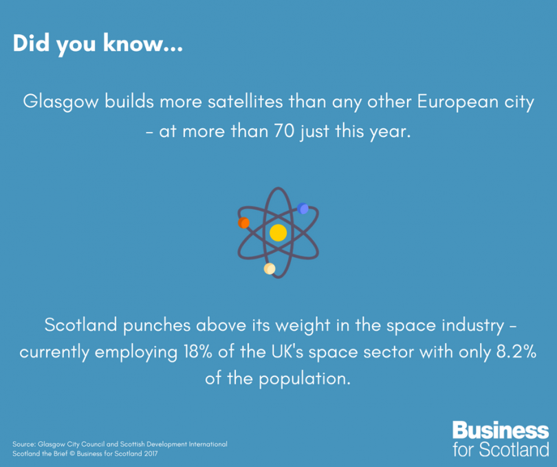
Glasgow manufactures the hardware, builds the space planes with orbital access.
On the East coast, we have the Edinburgh cluster. This is more skewed towards software. Many of these companies are associated with the University of Edinburgh and Herriot-Watt university. The space industry could be worth £4 billion by 2030. [3]
Scotland has a satellite edge since the Scottish Government is open to the sector. The geography is advantageous as it is quite far up North, satellites can be launched over the sea and there is a low population density.
Scottish companies are interested in all space-based industries from Earth observation to communications. Scotland has the added advantage that companies making the satellite systems and companies developing the GIS applications are all well connected. They are inbedded into the wider infrastructure of Scotland. [4]
Space Wheel in the Scottish Space Industry
The space wheel describes how to manage, maintain a space company. It goes through how to develop, design and deploy new satellites.
There are 10s of companies in Edinburgh and Glasgow, the competition is quite fierce for costumers and for data exclusivity.
The sector employs a 1000 people in design, manufacturing and launches. [5]
The Scottish space sector is booming and allowing more people to access space than ever before
How is Space based data useful for Geology and Geosciences?
A large chunk of geosciences rely on space based data. Data from satellites is needed to understand changes in the oceans, ice-sheets, how mountains move, how planets other than our own change and I could go on and on. Satellites revolutionized the science of geology!
Examples on why satellite data is useful in building geological models and atmospheric models:
NASA Tracks Volcanic Ash With Satellites
When a volcano erupts the ash plumes wreak havoc with the systems of the airplane. The clouds of ash and sulfur dioxide fly into the engines, creating a glass residue on the rotor blades of the turbine. (Volcanic ash is essentially tiny glass fragments. The ash particles get reheated when they enter the engines, melting again.) The design of the engine is precise, therefore the engines overheat and stall mid-air. This can only be remedied if the engines are switched off mid air, allowing cool air to flood the engines, cool down the glass surface on the rotors. When the volcanic glass cools, it shrinks in size, cracking off the turbine blades, allowing the engine to start up again. This turns the airplane into a glider, which causes the heavy passenger planes to stall, and fall out of the sky.
It is ideal for the plane to avoid the ash clouds in the first place.
There is one major problem with avoiding the ash clouds other than the ash blocking international flight paths. Ash is really difficult to detect via conventional means as for a pilot and for a radar technician, an ash cloud looks like ordinary rain-clouds. When planning a flight path, aviation agencies keep the locations of the ash plumes wide therefore forcing entire countries to ground their air fleets even when it is not necessary.
The technology showcased in the video bellow about tracking volcanic ash in the atmosphere was developed by Nickolay Krotkov.
The NASA/NOAA/DoD Suomi NPP satellite maps the particles emitted by the volcano such as sulfur-dioxide. The particles are mapped in a 3D space by the satellite taking measurements in 3 slides, across 3 cross sections. I find this a great new idea as in the past satellites were associated with 2D images and 2D projected data.
The data is integrated with models on the weather patterns of the area from the secondary weather satellites. This allows the prediction of the direction of travel for the atmospheric born ash. This enables a modeler to build a volcano ash forecast system that lasts from days to months. (I am frankly surprised that they can predict direction of travel for a month long period, most weather forecasts can predict the weather for a week and half in order to stay within a boundary of any form of accuracy). The demonstrator video is very impressive [6]:
Satellite Tracks Saharan Dust to Amazon in 3-D
I found this video a few months ago, so I shall include it here. This is a great demonstration of how NASA can track Saharan dust moving through the atmosphere from Africa to the Amazon jungles in South America. The dust contains several variety of nutrients such as iron and phosphorus, that doesn’t just fall on the Atlantic Ocean to maintain nutrients level there, but the dust itself falls down onto the Amazon basin maintaining the nutrient supply in the soil. In the tropics due to the heavy rain, the soils are thin and easily washed away. What keeps tropical soils productive is the constant recycling of material by the forests and outside source of nutrients such as dust from the Sahara. Jungles are deserts in a dress rehearsal, deserts in the wait. It is amazing to consider that a dust storm helps to keep the Amazon alive. There is a romantic element to it in the traditional 19th century style, that everything is interlinked and the planet operates like a fine clock.
Maybe the lyrics shouldn’t be “I bless the rains down in Africa” but “bless the dust storms of the Sahara” or “bless the rains down in the Amazon”.
So how doe the satellite track the particles of dust in the atmosphere which are carried on by the trade-winds?
The satellite doesn’t track the individual grains but the plumes that the grains themselves form when carried by the wind. The satellite builds a cross section of the atmosphere, which allows computers to use yearly data to predict the paths of future plumes.
The video is informational and explains the operation of the dust tracking satellite well [7]:
Tour of the Moon in 4K
NASA’s Goddard center built a 3D surface map of the Moon. The video bellow gives a quick walk through of how they did it, how they do the modelling and they highlight some interesting features of the Moon’s surface. This animation contains the map of the far side of the Moon.
I find it extremely amazing that with modern satellites, we on Earth, can take a look at the far side of the Moon, to look at the surfaces of other planets. The LRO remapped the geology of the Apollo 17 landing site for example. [8]
The walk through in the video is a great demonstration of satellite technology outside of the Earth (I find it cool how the satellite uses heat mapping to distinguish different geological zones of pyroxene and plagioclase) [9]:
New Podcast by the University
The university set up a podcast where one can keep up to date on all the news connected to space and the university in space. It takes a look at how the Scottish Government, our university and private industry teamed up to allow Scotland to have a share in the space sector:
Great Tweets
Bellow are a few examples on how scientists use satellites to understand our world and others better. The scientists bellow are volcanologists, geomorphologists and interplanetary geologists:
Celebrating #EarthSciWeek
Ben is studying a style of never-before-seen #explosive #volcanic eruptions in #Ethiopia & quantifying the #hazard & #risk they pose to surrounding populations & infrastructure#GeoscienceIsForEveryone #ImAnEarthScientist@geolsoc @GeosciencesEd @uoeKB pic.twitter.com/jm7RdjAJL1— Cockburn Geological Museum (@CockburnGeol) October 19, 2019
Global snow cover duration as a result of playing with @NASAEarth #MODIS data in @googleearth engine #Remotesensing #scicomm #snow #Datavisualization #sciart #GEE pic.twitter.com/PyW2ZIG1Ui
— Pekka Niittynen @snowman@ecoevo.social 🇫🇮🇪🇺🌎❄ (@PONiittynen) January 30, 2020
Fantastic keynote talk on the Sedimentology of Mars by Prof. Sanjeev Gupta @ImperialRSM this afternoon at @GeosciencesEd gradschool conference – showed the importance of detailed geological observations on the planet pic.twitter.com/6NqY1znqQh
— Stuart Gilfillan (@stugilfillan) February 8, 2020
'If science was solved, we'd have nothing to do!' Thanks to Sanjeev Gupta for his talk @GeosciencesEd #Gradschool conference. Exciting science from the @MarsCuriosity suggesting river channels on #Mars but also highlighting the importance of #collaberation and #perserverence! pic.twitter.com/8b85fc6wE5
— Hannah F Rogers (@Hannah_Rogers94) February 8, 2020
https://twitter.com/GBromiley/status/1187017535952175104
35 years of change on the Mamoré River, Bolivia, as seen in @NASA_Landsat images pic.twitter.com/Vt6TEdbvdt
— Zoltán Sylvester (@zzsylvester) December 21, 2019
Got an update from an Earthling that there was a fun session at the Astronomical Society of the Pacific conference this week. Astronomy educators made geology — art! https://t.co/MOteFizh1f pic.twitter.com/Rn5Epf1hMq
— NASA's Lunar Reconnaissance Orbiter (@LRO_NASA) December 8, 2017
References
[1] Lecture by Dr. Callum Norrie of Space Network Scotland
[2] Scotland. 2020. Scotland In Space | Scotland.Org. [online] Available at: <https://www.scotland.org/business/conferences-in-scotland/legends/space/scotland-in-space> [Accessed 18 May 2020].
[3] Scottish Government News. 2020. Scotland’S £4 Billion Space Sector. [online] Available at: <https://news.gov.scot/news/scotlands-gbp-4-billion-space-sector> [Accessed 18 May 2020].
[4] Vidmar, M. (2015). Knowledge Networks at the Heart of Space Industry: The Case of Scotland. 13th Reinventing Space Conference, 1–21.
[5] Opening space to everyone – The Glasgow Sloth. (n.d.). Retrieved May 20, 2020, from https://theglasgowsloth.com/opening-space-to-everyone/
[6] GMS: Tracking Volcanic Ash With Satellites. (n.d.). Retrieved June 3, 2020, from https://svs.gsfc.nasa.gov/cgi-bin/details.cgi?aid=12221
[7] Haase, I., Oberst, J., Scholten, F., Wählisch, M., Glser, P., Karachevtseva, I., & Robinson, M. S. (2012). Mapping the Apollo 17 landing site area based on Lunar Reconnaissance Orbiter Camera images and Apollo surface photography. Journal of Geophysical Research E: Planets, 117(5), 1–8. https://doi.org/10.1029/2011JE003908
[8] Rizzolo, J. A., Barbosa, C. G. G., Borillo, G. C., Godoi, A. F. L., Souza, R. A. F., Andreoli, R. V., Manzi, A. O., Sá, M. O., Alves, E. G., Pöhlker, C., Angelis, I. H., Ditas, F., Saturno, J., Moran-Zuloaga, D., Rizzo, L. V., Rosário, N. E., Pauliquevis, T., Yamamoto, C. I., Andreae, M. O., … Godoi, R. H. M. (2016). Mineral nutrients in Saharan dust and their potential impact on Amazon rainforest ecology. Atmospheric Chemistry and Physics Discussions, July, 1–43. https://doi.org/10.5194/acp-2016-557
[9] Shkuratov, Y. G., Kaydash, V. G., & Pieters, C. M. (2005). Lunar clinopyroxene and plagioclase: Surface distribution and composition. Solar System Research, 39(4), 255–266. https://doi.org/10.1007/s11208-005-0041-2


Recent comments