Any views expressed within media held on this service are those of the contributors, should not be taken as approved or endorsed by the University, and do not necessarily reflect the views of the University in respect of any particular issue.
Digimap is an online map and data delivery service, available by subscription to UK Higher and Further Education establishments. Operated by EDINA at the University of Edinburgh, Digimap offers a number of data collections, including Ordnance Survey, historical, geological, aerial photography, LiDAR, marine maps, land cover mapping, global mapping and census data. For more information about Digimap go to our website: https://digimap.edina.ac.uk Background image Contains OS data (c) Crown Copyright and database right 2022
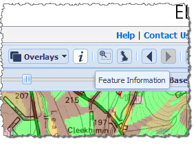
We have added the Feature Information tool to Environment Roam. This allows you to select points on the map to identify what the land use is at that location. Some of the colours used on the maps are very similar, which, while necessary with so many different categories, makes the maps more difficult to interpret. When the opacity slider is used to see the base map through the colours there can be even less distinction. The feature information tool helps to overcome this difficulty. The tool is also vital for those with a colour vision deficiency,
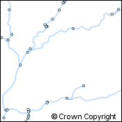
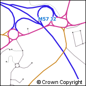
To identify the land use category for a particular point, click on the i button in the bar above the map:
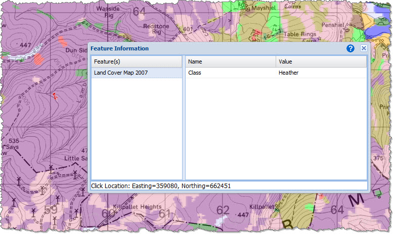
You will notice there is now a little question mark next to your mouse pointer, now click on a location to identify the land use at that point. A small red pin will appear on the map along with a box containing the information about the location clicked on:
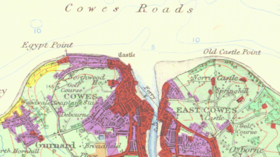
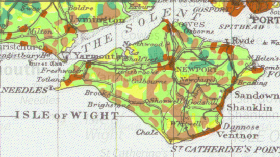
This feature has been a part of the Historic, Geology and Marine Roam interfaces for some time. However, it took much longer to develop this tool for Environment Roam because the data is very different. Rather than querying a database about the location we use colour matching technology to find the corresponding legend entry for the location clicked on. For this reason, we can’t operate the Feature Information tool on the 1930s Dudley Stamp maps. These maps were hand coloured, often by different people using different equipment, therefore the digital versions of the colours are inconsistent. Since the Dudley Stamp maps have fewer land use categories there is less confusion in identifying the appropriate colours in the legend, but we recognise that there may still be difficulties for those with colour vision deficiency.
GeoForum is a free all day event aimed at lecturers, researchers and support staff who promote and support the use of geospatial data and services at their institution. Throughout the day we there will be talks and demonstrations to inform you of current geospatial developments at EDINA and the wider community. It is also an opportunity to give EDINA feedback on the services we provide and discuss geospatial issues with the team.
Full details of this years event will and the programme will appear on the website when available:
This year Ordnance Survey’s cartography team will be telling us about how they go about creating cartographic representations of the map data. We’ll also be showcasing the work of students of architecture and urban design, highlighting how data from Digimap is crucial to their studies.
The conference will be located in the historical Queen Anne Court at the University of Greenwich, part of the Old Royal Naval College. In such surroundings we hope the weather will allow us to go outside for an afternoon excursion where we can show you the enhancements to our Fieldtrip mobile app while exploring the area. We will also be highlighting the many new datasets that have been added to Digimap over the recent months and giving you a sneak preview of what we will be doing over the summer to improve all the geoservices offered by EDINA.
The conference is free to attend and runs from 10:00 till 16:15, for all the details and to book your place please visit the conference website: GeoForum 2015
Please contact us if you have any questions:
Email: edina@ed.ac.uk
Phone: 0131 650 3302
Find out what happened at last year’s event: GeoForum 2014
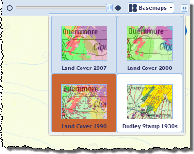
We have moved the Dudley Stamp Land Use Survey maps from the Historic Digimap Collection to their more natural home in Environment Roam. In doing so we have increased their usability. You can now pan and zoom much more easily and can print and annotate the maps, something that was not available in the previous Land Use Map Viewer.
Two scales of map are available for all of England, Scotland and Wales: 1:625,000 and 1:63,360.
Environment Roam automatically switches between these at the appropriate point when zooming in or out of the map.
To view the 1930s maps go to the Basemaps selector on the right hand side of Environment Roam and choose Dudley Stamp 1930s from the drop down window.
Ordnance Survey’s most detailed open data product, Open Map – Local, is now available to download from the Digimap service along with the OS Open Names gazetteer, OS Open Rivers water network and OS Open Roads road network. There are no restrictions on what the data can be used for, it just needs to carry a simple copyright acknowledgement:
This is a vector dataset best viewed at a scale of 1:10,000, with layers including buildings, roads, sites, railways, hydrology, coastline, woodland and cartographic text. The data comes in Shapefile format for easy access in the most commonly used GIS software.
The data isn’t quite as feature rich as the licensed VectorMap Local data, though it does contain some nice additions such as the ability to highlight public buildings and their grounds.
OS Open Names
This is a gazetteer with 2.5 million entries, made up of over 870,000 named and numbered roads, nearly 44,000 settlements and over 1.6 million postcodes. This dataset is billed as the comprehensive list of Great Britain’s place names, road names and numbers and postcodes, and is certainly the most detailed gazetteer in Digimap. The data is available in CSV or GML formats.
OS Open Rivers
This is a generalised network view of the rivers of Great Britain. The data is designed to give its users a high-level view of where the water flows across the land surface. Though it doesn’t show the detail of the actual width or shape of the river as the topographic data it is a proper network. This means it doesn’t get interrupted by bridges or other features that prevent the topographic data from being used to “route” water through the river network. The data is available in Shapefile and GML formats.
OS Open Roads
Like OS Open Rivers this is a generalised network of roads. Topographic data will provide more detail about the road dimensions and real world position, however this data provides an uninterrupted network for road routing analysis. The data is available in Shapefile and GML formats.
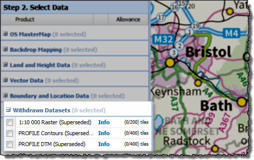
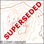
Ordnance Survey will withdraw two products in 2016, the 1:10 000 Raster data and the Land-Form PROFILE data. To remind you that these products will no longer be available from the Digimap service we are putting them in a new category in Data Download. The Withdrawn category will contain these datasets until we have to remove them from the site, March 2016 for the 1:10 000 Scale Raster and September 2016 for the Land-Form PROFILE contours and DTM.
Remember that the VectorMap Local Raster data is a more detailed generally better product to use than the 1:10 000 scale raster. If you really need the cartography of the old version, you can create a print map from Digimap Roam which styles the VectorMap Local data to look like the 1:10 000 Scale Raster. Just zoom in to the Street or Neighbourhood view levels and then use the Basemaps button at the top left of the map to change to the VML Raster 10k styling. An added advantage to doing this is that you can add in contour lines which were never available with the old data.
The Land-Form Profile data has also been superseded, you should now use the OS Terrain 5 data instead. Although it is not available in DXF format, Terrain 5 is a much improved dataset compared to the older data and it is still available in the following formats: GML, Shapefile (for the contours) and ASCII (for the DTM).
If you have any questions about the withdrawal of these datasets then please let us know:
As part of our work to demonstrate the value for money of the Digimap Collections, EDINA has calculated the commercial cost of all the data downloaded and maps created for printing. We calculated the values per institution for the period August 2013 to July 2014 then totalled them; this came to approximately £65.4 million. This estimate is a conservative one because we reduce the quantity of data downloaded by 60% to account for duplication. When all the maps printed and data downloaded were included in the calculation (i.e assuming users would continue to take their own data and maps, and not share them) this total rises to over £107 million.
Click to enlarge image
We know that some data is downloaded multiple times within an institution, for example by students for a class exercise or by researchers for specific study sites. We found that on average only 40% of the data taken from Digimap over a period of time was unique within an institution. We believe that if institutions were paying commercial rates for their data they would be more likely to download it once and circulate it to those who need it; this is why we reduce the amount of data included in our calculation. However, there is considerable variation between institutions as to how much is unique; those that do more research or are smaller in size tend to have a greater proportion of unique downloads, so we calculated the 100% figure as a ceiling value.
In total, over the past four academic years over £306 million (£170 million at 40%) worth of print maps and data has been served up from Digimap to subscribing institutions. The steep increase in 2013-14 was caused by more Ordnance Survey products being downloaded and printed than ever before and also by the high commercial costs of several products added to the Geology Digimap service.
How the Costs are Calculated
Click to enlarge image
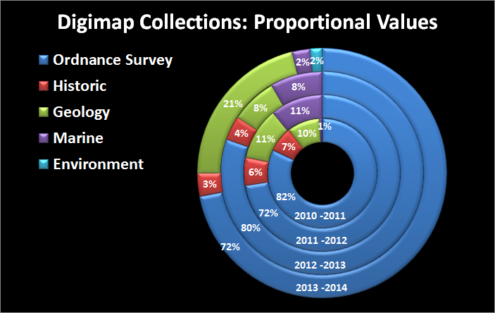
The costs used in our calculations for the data come from the list prices published by data suppliers, and include any relevant multipliers or discounts declared publicly on their websites.
The data costs we calculated are done on a per product / per institution basis, with the data preparation and licensing charges assigned only once per product, per institution (rather than per data request). Many of the data collections are commercially licensed based on the number of users who have access to the data; with increasing numbers of users a multiplier is applied to a base cost. We applied the relevant multipliers according to the number of active registered users for each Collection at an institution.
We capped data costs at the price of national coverage for each product, making it impossible to assign greater cost for any one product than it would be to supply the entire dataset for use by a whole institution.
The values for the print maps (including saved maps in all Roam applications) are calculated by finding the cheapest commercially available map prints from websites such as eMapsite, NLS and FiND.
What We Didn’t Include
Click to enlarge image
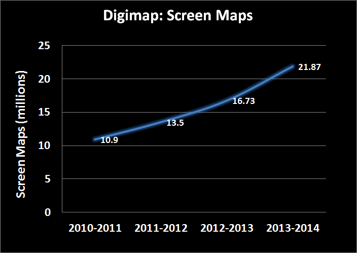
No monetary values were assigned to the millions of screen maps that are produced from Digimap. The value calculated also doesn’t take into account any of the help materials, training courses and support facilities that are all part of the Digimap service.
No OpenData downloads or maps created from OpenData are included in the calculation, despite the advantages of producing them from Digimap rather than other websites.
However, the biggest saving that isn’t included in these value calculations is your time. We only charged the data supplier’s preparation and licensing costs once per product or order, in line with each company’s policy where it applied. In reality there would be many orders occurring throughout an academic year as new research questions are raised. This all costs time, time which the data suppliers will charge for or that institutional staff would have to take to submit requests for data and time for staff to create and manage a repository for spatial data.
With 24 hour access to high quality data and maps through a purpose built mapping and data download interface, Digimap does all this work for its subscribers.
Over the coming weeks we will be sending out each institution’s data cost calculations to Digimap site representatives. If you are interested in the commercial costs of the maps and data your institution has been using please contact your site represenative. If you are unsure who your site representative is, please contact us:
Digimap’s new registration system was released on the 28th of January, we hope you’ll agree that it is a huge improvement over the previous version.
Users no longer have to wait up to 48 hours for registrations to be approved, they simply have to click a link in an email sent to them after filling in the registration form.
It already has its fans leading one site rep to say “I love the new registration system!” and another told us “Congratulations on instant registration for students. This is going to be very popular.”
The new instant access system is much more inline with user expectations from online services. Removing the need to wait overnight (or longer over weekends) to gain access has been very popular and has resulted in a significant increase in registrations during February. Over 6000 registrations were processed through the new system at all times of day and night!
We now need your help to make sure that the support material at your institution is up-to-date and that your students know that they can have access to the service the same day.
There is a full description of how to register using the new system in the help pages which guides you through the process:
If you are responsible for any local support pages, lecture notes, practical guides and any other course material please make sure these get updated. We actively encourage the incorporation of the images and text from the help page in any material produced. Please can you circulate this information as widely as possible to ensure that all users have up to date guidance.
One final plea is that you highlight the importance of entering the correct email address when registering. This should be an email address that is used regularly and it should be spelt correctly!
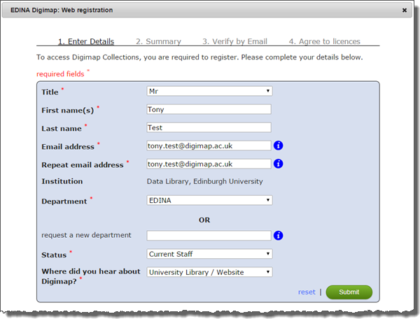
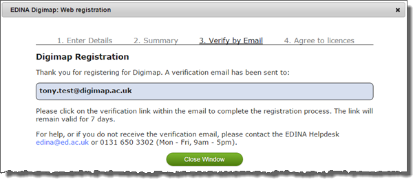
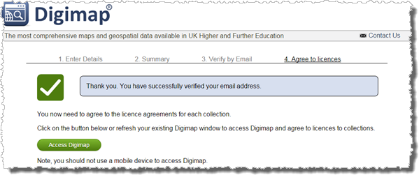
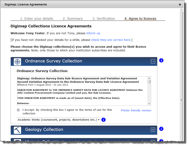
As blogged about last month, we have been working on a new Digimap registration system which will be released next Wednesday (28th January) The current registration system has been in place for over ten years. It has served us well, but it is now rather dated especially because users have to wait for their registration to be manually approved and processed overnight. The new registration system allows users to get instant access to Digimap. This will be a significant improvement and help those students that leave their Digimap coursework a bit late! At least now they will be able to get access quickly and easily (unfortunately we can’t guarantee they’ll get the work submitted on time though!) Detailed help pages will be available from Wednesday, once the release has been completed and Digimap is available to users. To help prepare site reps and support staff for the change, here is an overview of the registration process. Registering with Digimap Registration will now be an automated two-step process. Users will supply their details to register and then they must activate access to collections by agreeing to the individual licences. After logging into Digimap to start, users will be presented with the registration form to enter their name, email address, department, status and where they heard about Digimap. After hitting the submit button, users will be sent an email with a link to verify their account. Once they have successfully verified, they will be directed back to the Digimap homepage, where they then complete the next step of activating collection access. Agreeing to licence for Digimap collections (activating access)After verifying their email address, users will need to agree to the licences for each of the specific Digimap collections that they wish to use, this is done through the licence agreements page. Users will only be able to agree to licences for the collections that their institution subscribes to. Once the user has agreed to the licence(s) and hit the confirm button, they will have access to those Digimap collections. If the process is completed in one go, it takes no more than a few minutes. Much quicker than the current system! Existing users Existing users will not notice any change unless they have not been active in a collection for more than 12 months. Access to a collection expires after 12 months of inactivity. If that’s the case, they will be prompted to accept the licence when they try to access an application in that collection. Generally though, if someone has not accessed a particular collection for more than 12 months, we don’t expect they will activate access and therefore will not notice any change with the new system. Access to active collections will carry on as normal. If you have any questions or comments, please contact the EDINA Helpdesk at edina@ed.ac.uk
Today, on the 15th day of 2015, we mark 15 years of running Digimap!
This week in 2000 the Digimap national service was launched following a four year project phase.
We marked the first 10 years with an event in January 2010 a great day which summarised the first decade in some detail: Read about it here
A recent presentation given at the Royal Geographical Society Annual conference highlighted the growth of the service and more recent developments: View it on SlideShare
The service is more embedded in UK academia than ever before, in use at 160 universities and colleges with over 58,000 registered users at those institutions. As well as this we now have bespoke versions for Colleges and Schools. Over the 15 years we have registered almost 500,000 users to access the collections and they in turn have generated nearly 100 million screen maps and 3 million print maps. In terms of the value for money, during academic year 2012/13 alone, the conservative total for products downloaded or printed from all Digimap collections was nearly £44 million a figure that grows year on year.
Improvements to Digimap continue with several exciting developments already lined up in early 2015.
We have a series of workshops (More Details) as part of rolling programme of outreach which includes conferences and other events. Keep up to date on the following page: http://digimap.blogs.edina.ac.uk/events/
We continue to work closely with colleagues at Jisc in providing the Maps and geospatial data offering http://jisc.ac.uk/content/maps as well as with the Ordnance Survey directly for the data underpinning the service.
We are introducing a new registration system in January (26th to the 28th) and would like to give advance warning of the service disruption this is will cause.
New users will not be able to register for Digimap from 4pm on 26th January
All Digimap services will be unavailable all day on 27th January
Normal service will resume on 28th January
New registrations for Digimap, using the current system, will be closed from 4pm Monday 26th January to ensure that no registrations are lost during the changeover. All Digimap services will then be unavailable all day on Tuesday 27th January, while we put the new system in place. Once all the work is complete the service will be available again hopefully by midday on Wednesday 28th January.
We apologise for the inconvenience caused but due to the significant changes required to release the new system we must close access to Digimap during this time. We urge you to create any maps or download data that you may need during the period of service unavailability in advance.
The new registration system will allow users to register and instantly access Digimap Collections via email verification speeding up access for new users significantly. We hope that this will help make up for the fact that new users will be prevented from registering during the maintenance. Existing registered and active users will not notice any change once normal service has been resumed.
If you have any questions or concerns please contact us:
Email: edina@ed.ac.uk
Phone: 0131 650 3302
More details about how the new system looks and works will be posted on the Digimap blog in the New Year.

 You will notice there is now a little question mark next to your mouse pointer, now click on a location to identify the land use at that point. A small red pin will appear on the map along with a box containing the information about the location clicked on: