Any views expressed within media held on this service are those of the contributors, should not be taken as approved or endorsed by the University, and do not necessarily reflect the views of the University in respect of any particular issue.
Digimap is an online map and data delivery service, available by subscription to UK Higher and Further Education establishments. Operated by EDINA at the University of Edinburgh, Digimap offers a number of data collections, including Ordnance Survey, historical, geological, aerial photography, LiDAR, marine maps, land cover mapping, global mapping and census data. For more information about Digimap go to our website: https://digimap.edina.ac.uk Background image Contains OS data (c) Crown Copyright and database right 2022
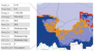
Geology Digimap now offers the new GeoCoast dataset, which replaces the Coastal Vulnerability dataset. GeoCoast is available from Geology Download under the Onshore Geology section. It is available in Shapefile format and only as a national datasets (it’s not possible to select a particular area – the whole dataset will be included in the download).
This Coastal Vulnerability dataset has been withdrawn and is no longer supported by BGS. However, it remains available through Geology Digimap under the Archived Datasets section. It is provided “as is” and used at your own risk.
Example of GeoCoast data courtesy of British Geological Survey.
Digimap is pleased to support GISRUK 2022 at the University of Liverpool. Below is the call for papers. If you have any enquiries about GISRUK, please contact gisruk2022@liverpool.ac.uk
We are pleased to invite you to submit a 1500 word extended abstract for the 30th Annual GIS Research UK (GISRUK) Conference, which will be held on the 5th – 8th April 2022. The conference will be hosted in person by the Department of Geography and Planning and the Geographic Data Science Lab at the University of Liverpool.
GISRUK is the largest academic conference in Geographic Information Science in the UK. For the last 30 years, GISRUK has attracted international researchers and practitioners in GIS and related fields, including geography, data science, urban planning and computer science, to share and discuss the latest advances in spatial computing and analysis. We welcome papers covering all aspects of geographical information science, both theoretical and applied. In addition, we also have a specific theme for the 2022 conference. We are particularly interested in receiving papers which focus on new forms of data and approaches, missingness and representation.
The closing date for abstract submissions is Monday 10th January 2022. Please submit your papers using the template available to download via the conference website. Abstracts should be submitted via EasyChair. All papers will be subject to peer review and allocated to short or long presentations, or poster presentations. Conference proceedings of all accepted papers will be made available online.
If you have any queries, please contact us via email at gisruk2022@liverpool.ac.uk. We look forward to receiving submissions and welcoming a diverse group of researchers to GISRUK 2022 in Liverpool.
GISRUK Organizing Committee (University of Liverpool)
Conference co-chairs: Jeremiah J Nieves and Cait Robinson
Early-career committee: Patrick Ballantyne, Olivia Horsefield, Gladys Kenyon, Natalie Rose
Welcome to the start of a new term and a new academic year! We very much hope that 2021/22 will be settled and productive with studies and research returning stronger than ever before. We have some exciting developments with Digimap for the coming session which we hope you will enjoy reading about and will find of use in your work over the coming year. As ever, we welcome feedback and suggestions; please don’t hesitate to contact us, either by email or on our social media channels (links below).
New Digimap Help Pages
We are delighted to report that this month we have launched a new Help system for Digimap. All our help pages have been reviewed, updated and re-presented. They are now easier to navigate and easier to read. We hope it will be much easier to find the help you need. We will continue to review, amend and update the information.
If you have bookmarks to the old help system, they will still work for a short period, but will not necessarily offer the most up to date information.
agCensus Digimap
Digimap’s newest data collection is the agCensus Digimap service offering agricultural census data for England, Scotland and Wales. These are grid-square estimates of a wide variety of farm statistics, ranging from farm workers, to strawberries, beef cattle to beetroot, derived from agricultural census surveys conducted by each national administration.
Your institution can subscribe to agCensus Digimap and access the data through our easy-to-use Data Download application.
Environment Digimap – new data
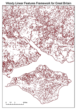
With thanks to the UK Centre for Ecology & Hydrology, Environment Digimap now offers three additional datasets. These are: Integrated Hydrological Digital Terrain Model, UKCEH 1:50,000 Digital River Network and Woody Linear Features Framework. Check out the new datasets in Environment Download.
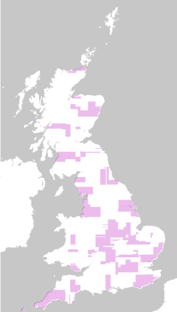
Despite so many challenges affecting the rest of our lives, 2020 was a fantastic year for flying aerial photography – some great, clear weather and almost all air traffic grounded because of the pandemic.
As a result, Aerial Digimap has had a bumper data update from Getmapping plc with 107,770 km2 of land covered by new images. This means 323,310 files or around 44% of data tiles have been updated! The first image shows the coverage of the new 2020 data. The second image shows the total coverage of aerial imagery flown within the last 3 years.
Coverage map of areas updated in the last 3 years
Coverage map of areas updated in 2020
Over the coming weeks the composite coverage available through Aerial Roam will be updated with the new data. In the meantime, 2020 data can already be downloaded from Aerial Download.
Improvement Service Data
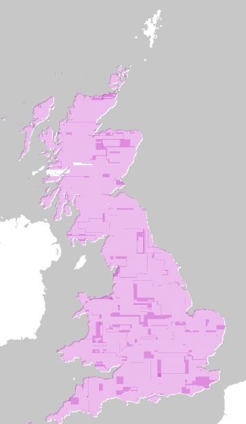
Your subscription to the Ordnance Survey Collection in Digimap now automatically includes Scottish local authority data from the Improvement Service. This collection covers more than 40 datasets created and curated by Scotland’s 32 local authorities. The data are wide ranging, from air quality management, alcohol prohibition areas and car parking, to care homes for the elderly, GP practices and school catchments. The data can be found in the OS Collection Data Download, under Improvement Service – Scotland.
We are pleased to announce the next webinar series for Digimap. Anyone is welcome to join these but placees are limited so please register online in good time. Recordings of previous webinars can be found on our YouTube channel.
These webinars are for those who are new to Digimap Collections. We will introduce the key features of Roam, our Digimap mapper, and consider when you would use Data Download. You will have the chance to ask questions.
Historic Digimap
10th November 2021, 12:30-1:15pm REGISTER
Guest speaker: Rick Crowhurst, Senior Public Sector Manager, Landmark Solutions
Find out what historical maps are available in Historic Digimap, which are provided by Landmark Solutions. Rick Crowhurst will tell us about the County, Town Plan and National Grid maps that you can access and their potential uses. The Digimap team will demonstrate the use of Historic Roam, where you can view, compare and print the maps. You will have the chance to ask questions.
Guest speaker: Russell Lawley, Product Development Team Leader, British Geological Survey
Find out about the range of British Geological Survey data products available in Geology Digimap from Russell Lawley of BGS Product Development. The Digimap team will demonstrate the use of Geology Roam, where you can view, compare and print the maps. You will have the chance to ask questions.
Here to help
The Digimap support team offers assistance to all Digimap users with the use of the service. If you have any questions about any aspect of Digimap, it’s use, the data it offers, subscriptions or its future, please get in touch.
The following Ordnance Survey event might be of interest to Digimap users:
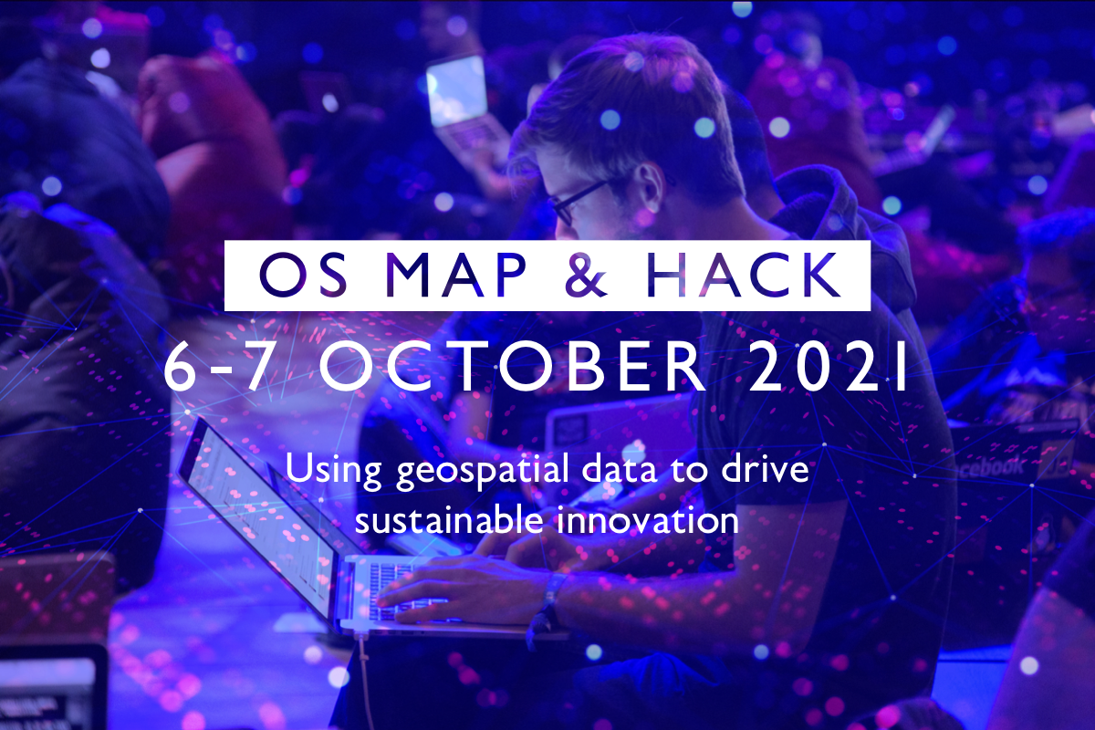
OS Map and Hack advertising image
OS Map & Hack is OS’ first virtual hackathon taking place on October 6 & 7, focusing on how spatial data contributes to solving real-world challenges around.
We are looking at the use of spatial data and how this can be used as we move towards sustainable alternatives across multiple market sectors. Spatial data is key to unlocking insights that determine how we are literally shaping our world. As the pace of technological innovation quickens, implementing the infrastructure and driving interest is crucial to widespread adoption across the country at a national, organisational, and individual level.
A panel of innovation and geospatial experts will be evaluating your contribution and looking for the strongest and innovative examples, which make best use of OS data and APIs.
Participants, entering as either individuals to be placed into a team or existing teams, will have an opportunity to work to four different challenges ranging from supporting local government to influencing consumer behaviours. The winners will receive collaboration time with OS technical and geospatial experts, Geovation memberships and a whole bunch of OS swag.
The event’s opening ceremony, pitching, judging, and closing ceremony will be held via Microsoft Teams. Collaboration will be taking place on Discord with workshops, activities and channels that provides participants the opportunity to collaborate with developers across public sector, private sector and the start-up community. Participants can also collaborate directly with the OS teams to ensure they’re getting the most effective use of OS data.
Challenges:
Challenge 1: levelling up – How can local governments use geospatial data for EV charging infrastructure and the transition to EV’s in remote communities.
Challenge 2: taking charge – What is the demand for charge points of EV fleets and where do these charge points need to be developed?
Challenge 3: the ‘real’ EV journey – How can we build the infrastructure to accurately reflect and represent the habits of the everyday EV user?
Challenge 4: open innovation – the open innovation challenges provides the freedom to design and build your own sustainable concept.
(Note: please do not contact EDINA or Digimap about this conference)
THe GISRUK Organising Committee are pleased to announce the 29th Annual GIS Research UK (GISRUK) Conference, hosted by Cardiff University, which will take place as a fully online event from Wednesday 14th April to Friday 16th April 2021. The whole conference will be fully open and free (£0).
Deadline for Registration: Wednesday 14th April 2021
The conference theme this year is the COVID19 pandemic and will include papers on mapping the spread of the disease and on the spatial analysis of its impact on such things as personal mobility, social inequalities and the outcomes of interventions such as stay at home orders.
The conference presentations will also include papers in the following areas:
Urban Analytics and Smart Cities
Urban infrastructure modelling and the built environment
Spatial and Spatio-temporal modelling
Cartography and Geovisualisation
Volunteered Geographic Information
Applications in transport, economics, health, and environmental science
GISRUK 2021 Early Career Researcher Workshop
Tuesday 13th April 2021
Calling all Masters’ students, PhD students, post-doctoral and early career researchers in the field of GI Science
This year there is a FREE on-line pre-GISRUK2021 conference Early Career Researcher Workshop on Tuesday 13th April 2021
GISRUK will feature a selection of ECR (Early Career Researcher) sessions. These will be a great opportunity for Masters’ and PhD students to get to know each other before start of the conference, and we will have sessions on ‘What is an (academic) conference?’, Careers (academic and non academic) in GI Science and Research (including grant writing and interdisciplinary collaboration). We will also have a session a couple of weeks before the main conference, dedicated to presenting online, to help you develop your presentations before the conference itself. All Masters’ and PhD students are welcome, as are early career post-docs and researchers. We will also be running a separate session (GISRUK for the uninitiated) for those who are new to the GISRUK conference series and would like to learn a bit more about it.
TWO WEEK REMINDER – SUBMISSION OF ABSTRACTS deadline extended until Monday 15th February 2021
We are pleased to invite you to submit a 1500 word extended abstract for the 29th Annual GIS Research UK (GISRUK) Conference, which will take place as a fully online event from Tuesday 13th April to Friday 16th April 2021. The whole conference will be fully open and free (£0) and is hosted by Cardiff University. Please see conference website for details:
We are running a webinar for any of you who are new to Digimap Collections, on 16th February at 11am GMT.
We will introduce the key features of our Digimap mapper, Roam, and consider when you would use Data Download. You will have the chance to ask questions. By the end of the webinar you will know:
* how to find out what maps and data we offer,
* how to browse different maps,
* add layers to your map,
* measure map features,
* add drawings,
* save and print maps.
EDINA have taken the difficult decision to withdraw the Ordnance Survey Northern Ireland (OSNI) data from Digimap at the end of the current subscription year on 31st July 2020. For those who have had a subscription to the OSNI data and have downloaded any licensed OSNI data from Digimap over the past 12 months you must now delete it since your licence to use and hold it has expired.
If you wish to continue using OSNI data, you should make appropriate licensing arrangements with OSNI directly, or through one of their partners.
Some OSNI data is available as Open Data. This will continue to be available through Digimap as previously. The Open Data is not covered by the recently expired Digimap licence for the OSNI data.
You may have noticed a new tab has appeared on the Digimap home page, labelled Noteable.
Noteable is a new service from EDINA, a cloud-based service which allows users to create, run & visualise code in a large number of computational languages. It can be used to access the unlimited opportunities of Python and/or R to build and manipulate data science models, addressing a wide variety of research problems. Noteable offers huge potential for geospatial data analysis and processing, making complex software environments and data models readily available to large numbers of students for remote learning.
Noteable builds and expands on Jupyter & RStudio technology to provide an efficient and collaborative learning environment. It offers low barriers to access with teachers able to set up the students’ environment once, and enables students to get started without the associated effort of setting up their own.